
La'ie, Hawai'i
Encyclopedia
Laie is a census-designated place
(CDP) located in the Koolauloa District on the island of Oahu
in Honolulu County
, Hawaii
, United States
. In Hawaiian
, lāie means "ie leaf" (ieie is a climbing screwpine
: Freycinetia arborea
). The population was 4,585 at the 2000 census.
The history of Laie begins long before first contact. The name Laie is said to derive from two Hawaiian words: lau meaning "leaf", and ie referring to the ieie (red-spiked climbing screwpine, Freycinetia arborea
), which wreaths forest trees of the uplands or mauka regions of the mountains of the Koʻolau Range behind the community of Laie. In Hawaiian mythology
, this red-spiked climbing screwpine is sacred to Kane
, god of the earth, god of life, and god of the forests, as well as to Laka
, the patron goddess of the hula
.
The name Laie becomes more environmentally significant through the Hawaiian oral history
(kaao ) entitled Laieikawai. In this history, the term ikawai, which means "in the water," also belongs to the food-producing tree called kalalaikawa. The kalalaikawa tree was planted in a place called Paliula's garden, which is closely associated with the spiritual home, after her birth and relocation of Laieikawai. According to Hawaiian oral traditions, the planting of the kalalaikawa tree in the garden of Paliula is symbolic of the reproductive energy of male and female, which union in turns fills the land with offspring. From its close association with nature through its name, and through its oral traditions and history, the community of Laie takes upon itself a precise identification and a responsibility in perpetuating life and in preserving all life forms. Sometimes the land itself provided sanctuary for the Hawaiian people. Laie was such a place. The earliest information about Laie states that it was a small, sparsely populated village with a major distinction: "it was a city of refuge." Within this city of refuge were located at least two heiau
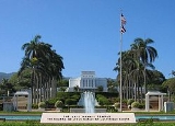
traditional Hawaiian temples, of which very little remains today. Moohekili heiau was destroyed, but its remains can be found in taro patches makai (seaward) of the LDS Church's Laie Hawaii Temple
. Towards the mountain (mauka), the remains of Nioi heiau can be found on a small ridge. All that is left of Nioi is a coral platform.
Between 1846 and 1848, the traditional Hawaiian feudal ownership of land by the king, the ali'i nui, and his leading chiefs or konohiki was changed through the Great mahele
, or major land division. The Ali’i nui at the time was Kauikeouli King Kamehameha III and his konohiki (leading chief) for Laie was Peni Keali’iwaiwaiole (which means The Chief without Riches); the wife to this konohiki descended directly from the Ali’i nui of Oahu named Kakuiewa, making his wife of higher rank than he. The result of the mahele was not in compliance with the original intent of Kamehameha III. The result was that the chiefs received about 1500000 acres (6,070.3 km²), the king kept about 1 million acres (4,046.9 km²), which were called crown lands, and about 1 million acres (4,046.9 km²) were set aside as government lands.
The land of the mahele itself was cut up into parcels, much like the traditional Hawaiian land divisions, centering around the ahupua'a
, which followed a fairly uniform pattern. Each parcel was shaped roughly like a piece of pie with the tip in the mountains, the middle section in the foothills and coastal plain, and the broad base along the ocean front and the sea. The size and shape of the ahupua'a varied. However, the purpose of these remained the same. The village of Laie is located in the ahupua'a of Laie. As such, Laie followed the general pattern of life in the ahupua'a, but only the valleys in the foothills had ample water. There were ten streams that flowed through the ahupua'a of Laie before 1865 (see 1865 map). Their names were: Kahooleinapea, Kaluakauila, Kahawainui, Kaihihi, Kawaipapa, Kawauwai, Wailele, Koloa, Akakii, and Kokololio. There were more streams flowing through the ahupua'a of Laie than through any of the other surrounding ahupua'a, surrounding ahupua'ainclude Kaipapau and Hauula to the southeast and Malaekahana, Keana, and Kahuku to the northwest.
Soon after the settlement a sugar factory was built. Much of the land was used to grow sugar, but other food crops were also raised. Significantly, Laie was one of the few sugar plantations where both kalo and sugar were grown simultaneously. This was unusual because sugar and kalo are both thirsty crops. In the plantation economy of Hawaii in the late 19th century and early 20th century, kalo usually lost out to sugar. One of the reasons both kalo and sugar grew on the plantation is because of the commitment of Hawaiian plantation workers to growing their staple. Their dedication to growing kalo included their insistence that Saturday not be a work day on the plantation so that they could make poi for their families. Both schools and church buildings were constructed in the town in the ensuing years.
Samuel E. Woolley, who served as mission president for 24 years, pushed the expansion of the operations at Laie. In 1898 he negotiated a $50,000 loan that allowed for the building of a new pump.
The Hawaiian mission was headquartered in Laie until 1919 when the headquarters were moved to Honolulu, but by then the temple had been built in Laie, so it remained the spiritual center of the Latter-day Saint community in Hawaii.
, the fifth oldest operating Mormon temple in the world which reopened Monday November 22, 2010. Brigham Young University Hawaii
is located in Laie. The university's Polynesian Cultural Center
, the state's largest living museum
, draws millions of visitors annually.
Though small, Laie has had a significant impact on Hawaiian culture, despite many of its residents' tracing their lineages from various Pacific Island countries such as Tonga
, Samoa
, Fiji
, and New Zealand
. Fundraisers and feasts on the beach in the late 1940s inspired "The Hukilau Song
", written, composed and originally recorded by Jack Owens, The Cruising Crooner, and made famous by Alfred Apaka
.
The zip code
for Laie is 96762.
According to the United States Census Bureau
, the CDP has a total area of 2.1 square miles (5.4 km²). 1.3 square miles (3.4 km²) of it is land and 0.9 square miles (2.3 km²) of it (40.65%) is water.
The coastline is marked by a prominent lithified dune
jutting out into the ocean as Laie Point. Two other lithified dunes (Kukuihoolua and Mokualai) lie just offshore of the point as scenic islet
s. Laie Beach Park has been known by many names over the years. Called Pahumoa Beach Park first and named as such after Pahumoa "John" Kamakeeāina (1879–1944), a fisherman from Lāie Maloo in the late 19th century and early 20th century who lived here and kept his nets on the beach adjacent to Kōloa Stream. He was well known in Lāʻie for his generosity and gave fish to everyone in the village, especially to those who could not fish for themselves. Pahumoa conducted many hukilau, a method of community net fishing. His family, the Kamakeeāinas, were a well known fishing family in the area and stories can still be found today of their abilities in fishing. To the south of town is "Pounders Beach," named for the pounding shorebreak. The name change occurred in the 1950s, when a group of students at the Church College of the Pacific (now Brigham Young University-Hawaii) called the beach "Pounders" after the shorebreak that provided popular bodysurfing rides; the nickname stuck. Another bodysurfing beach is "Hukilau Beach". The beach is located at the north end of town, at the mouth of Kahawainui Stream.
of 2000, there were 4,585 people, 903 households, and 735 families residing in the CDP. The population density
was 3,601.7 people per square mile (1,393.9/km²). There were 1,010 housing units at an average density of 793.4 per square mile (307.1/km²). The racial makeup of the CDP was 27.59% White, 0.35% Black or African American, 0.15% Native American, 9.23% Asian, 36.88% Pacific Islander, 0.65% from other races, and 25.15% from two or more races. Hispanic or Latino of any race were 3.12% of the population.
There were 903 households out of which 46.4% had children under the age of 18 living with them, 66.2% were married couples
living together, 10.9% had a female householder with no husband present, and 18.6% were non-families. 9.1% of all households were made up of individuals and 2.1% had someone living alone who was 65 years of age or older. The average household size was 4.47 and the average family size was 4.75.
In the CDP the population was spread out with 31.8% under the age of 18, 21.8% from 18 to 24, 26.8% from 25 to 44, 14.5% from 45 to 64, and 5.1% who were 65 years of age or older. The median age was 24 years. For every 100 females there were 90.5 males. For every 100 females age 18 and over, there were 85.9 males.
The median income for a household in the CDP was $50,875, and the median income for a family was $59,432. Males had a median income of $40,242 versus $26,750 for females. The per capita income
for the CDP was $13,785. About 10.7% of families and 17.5% of the population were below the poverty line, including 13.8% of those under the age of 18 and 11.6% of those ages 65 and older.
| publisher = Mutual Publishing
| year = 1998
| location = Honolulu, HI
| pages =
| isbn = 1-56647-211-3
}}
Census-designated place
A census-designated place is a concentration of population identified by the United States Census Bureau for statistical purposes. CDPs are delineated for each decennial census as the statistical counterparts of incorporated places such as cities, towns and villages...
(CDP) located in the Koolauloa District on the island of Oahu
Oahu
Oahu or Oahu , known as "The Gathering Place", is the third largest of the Hawaiian Islands and most populous of the islands in the U.S. state of Hawaii. The state capital Honolulu is located on the southeast coast...
in Honolulu County
Honolulu County, Hawaii
The City and County of Honolulu is a consolidated city–county located in the U.S. state of Hawaii. The municipality and county includes both the urban district of Honolulu and the rest of the island of Oahu, as well as several minor outlying islands, including all of the Northwestern Hawaiian...
, Hawaii
Hawaii
Hawaii is the newest of the 50 U.S. states , and is the only U.S. state made up entirely of islands. It is the northernmost island group in Polynesia, occupying most of an archipelago in the central Pacific Ocean, southwest of the continental United States, southeast of Japan, and northeast of...
, United States
United States
The United States of America is a federal constitutional republic comprising fifty states and a federal district...
. In Hawaiian
Hawaiian language
The Hawaiian language is a Polynesian language that takes its name from Hawaii, the largest island in the tropical North Pacific archipelago where it developed. Hawaiian, along with English, is an official language of the state of Hawaii...
, lāie means "ie leaf" (ieie is a climbing screwpine
Pandanaceae
Pandanaceae is a family of flowering plants native to the tropics of the Old World. Such a family has been widely recognized by taxonomists.Pandanaceae are trees or climbing or scrambling shrubs distributed in the Old World tropics and are adapted from sea level in salted beaches to mountain cloud...
: Freycinetia arborea
Freycinetia arborea
The Ieie is a densely branched, brittle, woody climber in the screwpalm family, Pandanaceae that is endemic to the Pacific Islands. Ieie is found in moist forest on the Hawaiian, Marquesas, Austral, Society, and Cook Islands. It grows into the forest canopy, attaching itself to a host tree using...
). The population was 4,585 at the 2000 census.
History
Historically, Laie was a puuhonua, a sanctuary for fugitives. While a fugitive was in the pu'uhonua, it was unlawful for that fugitive's pursuers to harm him or her. During wartime, spears with white flags attached were set up at each end of the city of refuge. If warriors attempted to pursue fugitives into the puuhonua, they would be killed by sanctuary priests. Fugitives seeking sanctuary in a city of refuge were not forced to permanently live within the confines of its walls. Instead, they were given two choices: In some cases, after a certain length of time (ranging from a couple of weeks to several years), fugitives could enter the service of the priests and assist in the daily affairs of the puuhonua. A second option was that after a certain length of time the fugitives would be free to leave and re-enter the world unmolested. Traditional cities of refuge were abolished in 1819.The history of Laie begins long before first contact. The name Laie is said to derive from two Hawaiian words: lau meaning "leaf", and ie referring to the ieie (red-spiked climbing screwpine, Freycinetia arborea
Freycinetia arborea
The Ieie is a densely branched, brittle, woody climber in the screwpalm family, Pandanaceae that is endemic to the Pacific Islands. Ieie is found in moist forest on the Hawaiian, Marquesas, Austral, Society, and Cook Islands. It grows into the forest canopy, attaching itself to a host tree using...
), which wreaths forest trees of the uplands or mauka regions of the mountains of the Koʻolau Range behind the community of Laie. In Hawaiian mythology
Hawaiian mythology
Hawaiian mythology refers to the legends, historical tales and sayings of the ancient Hawaiian people. It is considered a variant of a more general Polynesian mythology, developing its own unique character for several centuries before about 1800. It is associated with the Hawaiian religion...
, this red-spiked climbing screwpine is sacred to Kane
Kane Milohai
In Hawaiian mythology, Kāne-milo-hai is the brother of Kamohoalii, Pele, Kapo, Nāmaka and Hiiaka by Haumea. He is a minor figure in Hawaiian mythology, figuring most prominently in the story of Pele's journey along the island chain to Hawaii, and may be seen as a terrestrial counterpart to his...
, god of the earth, god of life, and god of the forests, as well as to Laka
Laka
In Hawaiian mythology, Laka is the name of a popular hero from Polynesian mythology....
, the patron goddess of the hula
Hula
Hula is a dance form accompanied by chant or song . It was developed in the Hawaiian Islands by the Polynesians who originally settled there. The hula dramatizes or portrays the words of the oli or mele in a visual dance form....
.
The name Laie becomes more environmentally significant through the Hawaiian oral history
Oral history
Oral history is the collection and study of historical information about individuals, families, important events, or everyday life using audiotapes, videotapes, or transcriptions of planned interviews...
(kaao ) entitled Laieikawai. In this history, the term ikawai, which means "in the water," also belongs to the food-producing tree called kalalaikawa. The kalalaikawa tree was planted in a place called Paliula's garden, which is closely associated with the spiritual home, after her birth and relocation of Laieikawai. According to Hawaiian oral traditions, the planting of the kalalaikawa tree in the garden of Paliula is symbolic of the reproductive energy of male and female, which union in turns fills the land with offspring. From its close association with nature through its name, and through its oral traditions and history, the community of Laie takes upon itself a precise identification and a responsibility in perpetuating life and in preserving all life forms. Sometimes the land itself provided sanctuary for the Hawaiian people. Laie was such a place. The earliest information about Laie states that it was a small, sparsely populated village with a major distinction: "it was a city of refuge." Within this city of refuge were located at least two heiau
Heiau
A heiau is a Hawaiian temple. Many types of heiau existed, including heiau to treat the sick , offer first fruits, offer first catch, start rain, stop rain, increase the population, ensure health of the nation, achieve success in distant voyaging, reach peace, and achieve success in war . Only the...
traditional Hawaiian temples, of which very little remains today. Moohekili heiau was destroyed, but its remains can be found in taro patches makai (seaward) of the LDS Church's Laie Hawaii Temple
Laie Hawaii Temple
Laie Hawaii Temple is a temple of The Church of Jesus Christ of Latter-day Saints located on the northeast shore of the Hawaiian island of Oahu. The temple sits on a small hill a half-mile from the Pacific Ocean in the town of Lāie, from Honolulu...
. Towards the mountain (mauka), the remains of Nioi heiau can be found on a small ridge. All that is left of Nioi is a coral platform.
Between 1846 and 1848, the traditional Hawaiian feudal ownership of land by the king, the ali'i nui, and his leading chiefs or konohiki was changed through the Great mahele
Great Mahele
The Great Mahele or just the Mahele was the Hawaiian land redistribution act proposed by King Kamehameha III in the 1830s and enacted in 1848.-Overview:...
, or major land division. The Ali’i nui at the time was Kauikeouli King Kamehameha III and his konohiki (leading chief) for Laie was Peni Keali’iwaiwaiole (which means The Chief without Riches); the wife to this konohiki descended directly from the Ali’i nui of Oahu named Kakuiewa, making his wife of higher rank than he. The result of the mahele was not in compliance with the original intent of Kamehameha III. The result was that the chiefs received about 1500000 acres (6,070.3 km²), the king kept about 1 million acres (4,046.9 km²), which were called crown lands, and about 1 million acres (4,046.9 km²) were set aside as government lands.
The land of the mahele itself was cut up into parcels, much like the traditional Hawaiian land divisions, centering around the ahupua'a
Ahupua'a
In old Hawaii, ahupuaa was the common subdivision of the land. It is comparable to the tapere in the Southern Cook Islands. The traditional subdivision has four hierarchical levels:*mokupuni *moku...
, which followed a fairly uniform pattern. Each parcel was shaped roughly like a piece of pie with the tip in the mountains, the middle section in the foothills and coastal plain, and the broad base along the ocean front and the sea. The size and shape of the ahupua'a varied. However, the purpose of these remained the same. The village of Laie is located in the ahupua'a of Laie. As such, Laie followed the general pattern of life in the ahupua'a, but only the valleys in the foothills had ample water. There were ten streams that flowed through the ahupua'a of Laie before 1865 (see 1865 map). Their names were: Kahooleinapea, Kaluakauila, Kahawainui, Kaihihi, Kawaipapa, Kawauwai, Wailele, Koloa, Akakii, and Kokololio. There were more streams flowing through the ahupua'a of Laie than through any of the other surrounding ahupua'a, surrounding ahupua'ainclude Kaipapau and Hauula to the southeast and Malaekahana, Keana, and Kahuku to the northwest.
Latter-day Saints
A new phase of development for Laie began when the plantation of that name was purchased by George Nebeker, the President of the Hawaiian Mission of The Church of Jesus Christ of Latter-day Saints. The Latter-day Saints in Hawaii were then encouraged to move to this location. This purchase occurred in 1865. The sugar plantation was rarely profitable, and through 1879 the church had subsidized its operations with about $40,000.Soon after the settlement a sugar factory was built. Much of the land was used to grow sugar, but other food crops were also raised. Significantly, Laie was one of the few sugar plantations where both kalo and sugar were grown simultaneously. This was unusual because sugar and kalo are both thirsty crops. In the plantation economy of Hawaii in the late 19th century and early 20th century, kalo usually lost out to sugar. One of the reasons both kalo and sugar grew on the plantation is because of the commitment of Hawaiian plantation workers to growing their staple. Their dedication to growing kalo included their insistence that Saturday not be a work day on the plantation so that they could make poi for their families. Both schools and church buildings were constructed in the town in the ensuing years.
Samuel E. Woolley, who served as mission president for 24 years, pushed the expansion of the operations at Laie. In 1898 he negotiated a $50,000 loan that allowed for the building of a new pump.
The Hawaiian mission was headquartered in Laie until 1919 when the headquarters were moved to Honolulu, but by then the temple had been built in Laie, so it remained the spiritual center of the Latter-day Saint community in Hawaii.
Community
Laie is one of the best known communities of The Church of Jesus Christ of Latter-day Saints and the site of the Laie Hawaii TempleLaie Hawaii Temple
Laie Hawaii Temple is a temple of The Church of Jesus Christ of Latter-day Saints located on the northeast shore of the Hawaiian island of Oahu. The temple sits on a small hill a half-mile from the Pacific Ocean in the town of Lāie, from Honolulu...
, the fifth oldest operating Mormon temple in the world which reopened Monday November 22, 2010. Brigham Young University Hawaii
Brigham Young University Hawaii
Brigham Young University–Hawaii is a private university located in Laie, Hawaii. It is owned and operated by The Church of Jesus Christ of Latter-day Saints ....
is located in Laie. The university's Polynesian Cultural Center
Polynesian Cultural Center
The Polynesian Cultural Center is a Polynesian-themed theme park or living museum located in Laie, on the northern shore of Oahu, Hawaii. Dedicated on October 12, 1963, the PCC occupies owned by nearby Brigham Young University–Hawaii....
, the state's largest living museum
Living museum
A living museum is a type of museum, in which historical events showing the life in ancient times are performed, especially in ethnographic or historical views, or processes for producing a commercial product in terms of technical and technological developments are shown, especially the craft...
, draws millions of visitors annually.
Though small, Laie has had a significant impact on Hawaiian culture, despite many of its residents' tracing their lineages from various Pacific Island countries such as Tonga
Tonga
Tonga, officially the Kingdom of Tonga , is a state and an archipelago in the South Pacific Ocean, comprising 176 islands scattered over of ocean in the South Pacific...
, Samoa
Samoa
Samoa , officially the Independent State of Samoa, formerly known as Western Samoa is a country encompassing the western part of the Samoan Islands in the South Pacific Ocean. It became independent from New Zealand in 1962. The two main islands of Samoa are Upolu and one of the biggest islands in...
, Fiji
Fiji
Fiji , officially the Republic of Fiji , is an island nation in Melanesia in the South Pacific Ocean about northeast of New Zealand's North Island...
, and New Zealand
New Zealand
New Zealand is an island country in the south-western Pacific Ocean comprising two main landmasses and numerous smaller islands. The country is situated some east of Australia across the Tasman Sea, and roughly south of the Pacific island nations of New Caledonia, Fiji, and Tonga...
. Fundraisers and feasts on the beach in the late 1940s inspired "The Hukilau Song
The Hukilau Song
"The Hukilau Song" is a song written by Jack Owens in 1948 after attending a luau in Laie, Hawaii.-Covers:Extremely popular, the song has been covered many times by a variety of artists.*Alfred Apaka*Ab Orchestra*Bing Crosby*Book 'em Danno...
", written, composed and originally recorded by Jack Owens, The Cruising Crooner, and made famous by Alfred Apaka
Alfred Apaka
Alfred Apaka was born Alfred Aholo Apaka Jrin Honolulu, Hawaii to vocalist Alfred Aholo Apaka Sr. Alfred was a graduate of President Theodore Roosevelt High School where he was an athlete and ROTC cadet captain...
.
The zip code
ZIP Code
ZIP codes are a system of postal codes used by the United States Postal Service since 1963. The term ZIP, an acronym for Zone Improvement Plan, is properly written in capital letters and was chosen to suggest that the mail travels more efficiently, and therefore more quickly, when senders use the...
for Laie is 96762.
Geography
Laie is located at 21°38′55"N 157°55′32"W (21.648500, -157.925569). Laie is located north of Hauula and south of Kahuku along Kamehameha Highway (State Rte. 83).According to the United States Census Bureau
United States Census Bureau
The United States Census Bureau is the government agency that is responsible for the United States Census. It also gathers other national demographic and economic data...
, the CDP has a total area of 2.1 square miles (5.4 km²). 1.3 square miles (3.4 km²) of it is land and 0.9 square miles (2.3 km²) of it (40.65%) is water.
The coastline is marked by a prominent lithified dune
Dune
In physical geography, a dune is a hill of sand built by wind. Dunes occur in different forms and sizes, formed by interaction with the wind. Most kinds of dunes are longer on the windward side where the sand is pushed up the dune and have a shorter "slip face" in the lee of the wind...
jutting out into the ocean as Laie Point. Two other lithified dunes (Kukuihoolua and Mokualai) lie just offshore of the point as scenic islet
Islet
An islet is a very small island.- Types :As suggested by its origin as islette, an Old French diminutive of "isle", use of the term implies small size, but little attention is given to drawing an upper limit on its applicability....
s. Laie Beach Park has been known by many names over the years. Called Pahumoa Beach Park first and named as such after Pahumoa "John" Kamakeeāina (1879–1944), a fisherman from Lāie Maloo in the late 19th century and early 20th century who lived here and kept his nets on the beach adjacent to Kōloa Stream. He was well known in Lāʻie for his generosity and gave fish to everyone in the village, especially to those who could not fish for themselves. Pahumoa conducted many hukilau, a method of community net fishing. His family, the Kamakeeāinas, were a well known fishing family in the area and stories can still be found today of their abilities in fishing. To the south of town is "Pounders Beach," named for the pounding shorebreak. The name change occurred in the 1950s, when a group of students at the Church College of the Pacific (now Brigham Young University-Hawaii) called the beach "Pounders" after the shorebreak that provided popular bodysurfing rides; the nickname stuck. Another bodysurfing beach is "Hukilau Beach". The beach is located at the north end of town, at the mouth of Kahawainui Stream.
Demographics
As of the censusCensus
A census is the procedure of systematically acquiring and recording information about the members of a given population. It is a regularly occurring and official count of a particular population. The term is used mostly in connection with national population and housing censuses; other common...
of 2000, there were 4,585 people, 903 households, and 735 families residing in the CDP. The population density
Population density
Population density is a measurement of population per unit area or unit volume. It is frequently applied to living organisms, and particularly to humans...
was 3,601.7 people per square mile (1,393.9/km²). There were 1,010 housing units at an average density of 793.4 per square mile (307.1/km²). The racial makeup of the CDP was 27.59% White, 0.35% Black or African American, 0.15% Native American, 9.23% Asian, 36.88% Pacific Islander, 0.65% from other races, and 25.15% from two or more races. Hispanic or Latino of any race were 3.12% of the population.
There were 903 households out of which 46.4% had children under the age of 18 living with them, 66.2% were married couples
Marriage
Marriage is a social union or legal contract between people that creates kinship. It is an institution in which interpersonal relationships, usually intimate and sexual, are acknowledged in a variety of ways, depending on the culture or subculture in which it is found...
living together, 10.9% had a female householder with no husband present, and 18.6% were non-families. 9.1% of all households were made up of individuals and 2.1% had someone living alone who was 65 years of age or older. The average household size was 4.47 and the average family size was 4.75.
In the CDP the population was spread out with 31.8% under the age of 18, 21.8% from 18 to 24, 26.8% from 25 to 44, 14.5% from 45 to 64, and 5.1% who were 65 years of age or older. The median age was 24 years. For every 100 females there were 90.5 males. For every 100 females age 18 and over, there were 85.9 males.
The median income for a household in the CDP was $50,875, and the median income for a family was $59,432. Males had a median income of $40,242 versus $26,750 for females. The per capita income
Per capita income
Per capita income or income per person is a measure of mean income within an economic aggregate, such as a country or city. It is calculated by taking a measure of all sources of income in the aggregate and dividing it by the total population...
for the CDP was $13,785. About 10.7% of families and 17.5% of the population were below the poverty line, including 13.8% of those under the age of 18 and 11.6% of those ages 65 and older.
Education
Laie is within the Hawaii Department of Education. Laie Elementary School is in the CDP.Further reading
ahu's Hidden History: Tours Into the Past| publisher = Mutual Publishing
| year = 1998
| location = Honolulu, HI
| pages =
| isbn = 1-56647-211-3
}}