

Kirknewton, West Lothian
Encyclopedia
West Lothian
West Lothian is one of the 32 unitary council areas in Scotland, and a Lieutenancy area. It borders the City of Edinburgh, Falkirk, North Lanarkshire, the Scottish Borders and South Lanarkshire....
, Scotland
Scotland
Scotland is a country that is part of the United Kingdom. Occupying the northern third of the island of Great Britain, it shares a border with England to the south and is bounded by the North Sea to the east, the Atlantic Ocean to the north and west, and the North Channel and Irish Sea to the...
. Its population is about 2200 (in 2011). It lies south of the A71
A71 road
The A71 is a major road in Scotland linking Edinburgh with Lanarkshire and Ayrshire. It adjoins the Livingston Bypass A899.It runs south west from Edinburgh for approximately 70 miles, through Saughton, Wilkieston and south of Livingston, Whitburn and Wishaw, then by way of the Garrion Bridge,...
from Edinburgh
Edinburgh
Edinburgh is the capital city of Scotland, the second largest city in Scotland, and the eighth most populous in the United Kingdom. The City of Edinburgh Council governs one of Scotland's 32 local government council areas. The council area includes urban Edinburgh and a rural area...
to Livingston
Livingston, Scotland
Livingston is a town in West Lothian, Scotland. It is the fourth post-WWII new town to be built in Scotland, designated in 1962. It is about 15 miles west of Edinburgh and 30 miles east of Glasgow, and is bordered by the towns of Broxburn to the northeast and Bathgate to the northwest.Livingston...
, and north of the A70
A70 road
The A70 road is a major road in Scotland, United Kingdom. It runs a total of from Edinburgh to Ayr. It begins in Gorgie, Edinburgh, as Ardmillan Terrace from a junction with the A71 and ends as Holmston Road in Ayr going by but not through Lanark...
, the high-level road that runs along the north side of the Pentland Hills
Pentland Hills
The Pentland Hills are a range of hills to the south-west of Edinburgh, Scotland. The range is around 20 miles in length, and runs south west from Edinburgh towards Biggar and the upper Clydesdale.Some of the peaks include:* Scald Law...
from Edinburgh to Carnwath
Carnwath
Carnwath is a moorland village on the southern edge of the Pentland Hills of Lanarkshire, Scotland. The village lies about south of both Edinburgh and Glasgow...
and Lanark
Lanark
Lanark is a small town in the central belt of Scotland. Its population of 8,253 makes it the 100th largest settlement in Scotland. The name is believed to come from the Cumbric Lanerc meaning "clear space, glade"....
. Much of the village stands back from the B7031, which links the two main "A" roads.
History
Iron Age
The Iron Age is the archaeological period generally occurring after the Bronze Age, marked by the prevalent use of iron. The early period of the age is characterized by the widespread use of iron or steel. The adoption of such material coincided with other changes in society, including differing...
forts on Kaimes Hill and Dalmahoy
Dalmahoy
Dalmahoy is hotel and former country house near Edinburgh, the capital of Scotland. It is located off the A71 road, south of Ratho. The house is protected as a category A listed building, while the grounds are included in the Inventory of Gardens and Designed Landscapes in Scotland, the national...
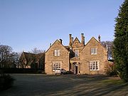
Hill, craggy summits about a mile east of Kirknewton. In slightly more recent times, Kirknewton House, which lies just to the south of the village, had its origins (as Meadowbank House) in the 17th century. The current house is a reworking of the original by the architect William Playfair
William Henry Playfair
William Henry Playfair FRSE was one of the greatest Scottish architects of the 19th century, designer of many of Edinburgh's neo-classical landmarks in the New Town....
for Alexander Maconochie, Lord Meadowbank
Alexander Maconochie, Lord Meadowbank
Alexander Maconochie, later Maconochie-Welwood , was a Scottish judge.The son of Allan Maconochie, Lord Meadowbank, he was admitted as an advocate in 1799...
in 1835. Kirknewton House is screened by trees from nearby roads and from the village itself. The most obvious evidence of its existence is the entrance lodge beside the start of the drive to the house at the south end of the village.
Kirknewton stood at the south eastern corner of the large area of West Lothian which was transformed from the 1860s by the oil shale
Oil shale
Oil shale, an organic-rich fine-grained sedimentary rock, contains significant amounts of kerogen from which liquid hydrocarbons called shale oil can be produced...
industry, with the nearest shale mine lying just to the north west of the village, between it and East Calder
East Calder
East Calder is a small town located in West Lothian, Scotland. It is located about a mile east of Mid Calder and about a mile west of Wilkieston...
. Shale from here was taken to the huge oil shale works at Pumpherston
Pumpherston
Pumpherston is a small dormitory village in West Lothian, Scotland. Originally a small industrial village to the nearby shale mine and works, it now adjoins the new town of Livingston, which was constructed alongside Pumpherston in the late 1960s and quickly grew much larger than its...
for processing.
During World War II
World War II
World War II, or the Second World War , was a global conflict lasting from 1939 to 1945, involving most of the world's nations—including all of the great powers—eventually forming two opposing military alliances: the Allies and the Axis...
, the Royal Air Force
Royal Air Force
The Royal Air Force is the aerial warfare service branch of the British Armed Forces. Formed on 1 April 1918, it is the oldest independent air force in the world...
built a military airfield at Whitemoss, a mile south east of Kirknewton. RAF Kirknewton
RAF Kirknewton
RAF Kirknewton is a Royal Air Force station at Whitemoss, a mile south east of Kirknewton, West Lothian, Scotland.Primarily an RAF radar base, RAF Kirknewton was home to a variety of units during the war. No...
, as it was known, was home to a variety of units during the war and, like many other military airfields, fell quiet afterwards. In 1952 it became home to a number of small United States Air Force
United States Air Force
The United States Air Force is the aerial warfare service branch of the United States Armed Forces and one of the American uniformed services. Initially part of the United States Army, the USAF was formed as a separate branch of the military on September 18, 1947 under the National Security Act of...
units tasked with providing mobile radio facilities to the USAF in Britain. The USAF left in 1966, and today Kirknewton airfield is home to a RAF(V)
Royal Air Force Volunteer Reserve
The Royal Air Force Volunteer Reserve consists of a number of groupings of individual military reservists for the management and operation of the Royal Air Force's Air Training Corps and CCF Air Cadet formations, Volunteer Gliding Squadrons , Air Experience Flights, and also to form the...
Gliding Unit, 661(RAF Kirknewton)VGS.
The village
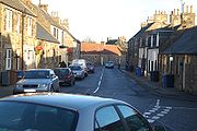
Kirknewton's Main Street has a very enclosed feel. Stretching from the junction with the B7031 to the old kirkyard in the centre of the village, it consists of a collection of one and two storey buildings. The kirkyard itself is home to a number of headstones dating back to the 18th century, and a burial enclosure for the Campbell Maconachies of Meadowbank House that dates back to 1662.The other burial enclosure was constructed by the Royal Society of Physicians as a memorial for an important founding member, William Cullen. Professor Cullen was a significant figure in 18th century medicine, chemistry, agriculture and practised the application of science to agriculture at a nearby farm acquired by him in the 1870s.
At the west end of the village is Kirknewton railway station
Kirknewton railway station
Kirknewton railway station is a railway station serving Kirknewton in West Lothian, Scotland, Opened as Kirknewton in February 1848, the station was renamed Midcalder and Kirknewton after two months, before becoming Midcalder in 1855. The full circle was finally completed 127 years later in May...
, officially known as Midcalder Railway Station until the 1980s. Where the B7031 crosses the railway line at the west end of the station is a level crossing
Level crossing
A level crossing occurs where a railway line is intersected by a road or path onone level, without recourse to a bridge or tunnel. It is a type of at-grade intersection. The term also applies when a light rail line with separate right-of-way or reserved track crosses a road in the same fashion...
that in recent years has seen a series of collisions between cars and trains.