

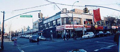
Kings Highway (Brooklyn)
Encyclopedia
New York City
New York is the most populous city in the United States and the center of the New York Metropolitan Area, one of the most populous metropolitan areas in the world. New York exerts a significant impact upon global commerce, finance, media, art, fashion, research, technology, education, and...
borough
Borough (New York City)
New York City, one of the largest cities in the world, is composed of five boroughs. Each borough now has the same boundaries as the county it is in. County governments were dissolved when the city consolidated in 1898, along with all city, town, and village governments within each county...
of Brooklyn
Brooklyn
Brooklyn is the most populous of New York City's five boroughs, with nearly 2.6 million residents, and the second-largest in area. Since 1896, Brooklyn has had the same boundaries as Kings County, which is now the most populous county in New York State and the second-most densely populated...
. The west end is at Bay Parkway and 78th Street. East of Ocean Avenue
Ocean Avenue (Brooklyn)
Ocean Avenue is a major street in Brooklyn, New York that runs generally north-south and occupies the position of East 20th Street in the Brooklyn street grid, with East 19th Street to its west and East 21st Street to its east for most of its path. It runs east of and parallel to Ocean Parkway and...
the street becomes mostly residential, tending generally east, then northeast, then north through Brooklyn and reaching East 98th Street in central Brooklyn. At that point, it flows into Howard Avenue to provide seamless access to Eastern Parkway, another major road in Brooklyn with side medians and service roads.
A Business Improvement District
Business improvement district
A business improvement district is a defined area within which businesses pay an additional tax or fee in order to fund improvements within the district's boundaries. Grant funds acquired by the city for special programs and/or incentives such as tax abatements can be made available to assist...
serves stores, restaurants and businesses along part of the road.
History
Although not entirely built in 1704, "King's HighwayKing's Highway (Charleston to Boston)
The King's Highway is a route over in length in the eastern United States. It joins Charleston, South Carolina, to Boston, Massachusetts. It was named after Charles II of England, who in 1650 directed his colonial governors to build it. It did not become a continuous wagon road until 1735...
" came into existence when many smaller established roads, cow paths, and Indian trails were finally linked that year. The Highway was named after the county, which was named in honor of King Charles II of England
Charles II of England
Charles II was monarch of the three kingdoms of England, Scotland, and Ireland.Charles II's father, King Charles I, was executed at Whitehall on 30 January 1649, at the climax of the English Civil War...
on November 1, 1683.
Fulton Ferry, Brooklyn
Fulton Ferry is a neighborhood in the New York City borough of Brooklyn. The neighborhood is named for a prominent ferry line crossing the East River between Manhattan and Brooklyn, and is also the name of the ferry slip on the Brooklyn side...
, where Ferry Road, now called Old Fulton Street and Furman Street are now, and ran southeastward to the small Dutch town of New Amersfort, now known as Flatlands
Flatlands, Brooklyn
Flatlands is a neighborhood in the New York City borough of Brooklyn. The area is part of Brooklyn Community Board 18.One of the original five Dutch towns on Long Island , this neighborhood was originally known as Nieuw Amersfoort, after the Dutch city of Amersfoort, but the name was changed to...
. It took a sharp westward turn at that point and swept into another of Brooklyn's original six towns, New Utrecht
New Utrecht, Brooklyn
New Utrecht was the last of six towns to be founded in what is today the borough of Brooklyn in New York City. It was named after the city of Utrecht, Netherlands. In 1652 Cornelius van Werckhoven, a surveyor born in Utrecht and a principal investor in the Dutch West India Company, began purchasing...
, and on into Yellow Hook (Bay Ridge
Bay Ridge, Brooklyn
Bay Ridge is a neighborhood in the southwest corner of the New York City borough of Brooklyn, USA. It is bounded by Sunset Park on the north, Seventh Avenue and Dyker Heights on the east, The Narrows Strait, which partially houses the Belt Parkway, on the west and 86th Street and Fort Hamilton on...
), ending at Denyse's Ferry, operated by a colonial-era landowner, about where Shore Road and 86th Street meet today. In southwest Brooklyn
Brooklyn
Brooklyn is the most populous of New York City's five boroughs, with nearly 2.6 million residents, and the second-largest in area. Since 1896, Brooklyn has had the same boundaries as Kings County, which is now the most populous county in New York State and the second-most densely populated...
, the thoroughfare had other names, including: "State Road," "Road from Fort Hamilton to New Utrecht," and "Road from New Utrecht to Denyse's Ferry."
According to the Dyker Heights Historical Society, the Highway ended at the ferry landing in what is now Fort Hamilton, Brooklyn
Fort Hamilton, Brooklyn
Fort Hamilton is a neighborhood in the far southwestern corner of the New York City borough of Brooklyn. It is located south of, and often considered part of, Bay Ridge. The area stretches from 86th Street as its northern border to 101st Street/the Narrows at the south; it is bounded by New York...
. In 1740 Denyse, a local New Utrecht resident took over ferry operations in The Narrows, serving Brooklyn
Brooklyn
Brooklyn is the most populous of New York City's five boroughs, with nearly 2.6 million residents, and the second-largest in area. Since 1896, Brooklyn has had the same boundaries as Kings County, which is now the most populous county in New York State and the second-most densely populated...
and Staten Island
Staten Island
Staten Island is a borough of New York City, New York, United States, located in the southwest part of the city. Staten Island is separated from New Jersey by the Arthur Kill and the Kill Van Kull, and from the rest of New York by New York Bay...
. “Denyse’s Ferry” was located at the base of the hill on which Fort Hamilton
Fort Hamilton
Historic Fort Hamilton is located in the southwestern corner of the New York City borough of Brooklyn surrounded by the communities of Bay Ridge, Dyker Heights, and Bensonhurst, and is one of several posts that are part of the region which is headquartered by the Military District of Washington...
was built, near today’s Fort Hamilton Parkway and Shore Road. Kings Highway traveled northeast from Denyse’s Ferry until present-day 86th Street. This portion of the Highway is known as Fort Hamilton Parkway. At the corner of Kings Highway and 86th Street stood New Utrecht Town Hall, built in 1878 (demolished in 1912). This building was also used as a school, police station, and jail. Kings Highway then traveled northeast, at about a 40-degree angle to the street grid, until it reached the middle of 81st Street between Eleventh and Twelfth Avenues. At the intersection of the current-day 81st Street and Eleventh Avenue, Denyse’s Lane branched off in a northwardly direction. St. Phillips Church in Dyker Heights now sits on part of this lane, which meandered down to Van Brunt’s Dock in Bay Ridge. Closer to Bay Ridge, Denyse’s Lane was known as Van Brunt’s Lane, present-day 79th Street.
The highest natural point in southwestern Brooklyn
Brooklyn
Brooklyn is the most populous of New York City's five boroughs, with nearly 2.6 million residents, and the second-largest in area. Since 1896, Brooklyn has had the same boundaries as Kings County, which is now the most populous county in New York State and the second-most densely populated...
is at Eleventh Avenue and 82nd Street, at Dyker Heights. During the time of Kings Highway, the hill it was known as New Utrecht Mount, which according to the Brooklyn Eagle
Brooklyn Eagle
The Brooklyn Daily Bulletin began publishing when the original Eagle folded in 1955. In 1996 it merged with a newly revived Brooklyn Daily Eagle, and now publishes a morning paper five days a week under the Brooklyn Daily Eagle name...
gave “the soldiers of revolutionary time an outlook from which they could note the movements of their opponents, not only as they approached from the sea, but maneuvered on Staten Island.” At 81st Street and Twelfth Avenue was Flax Pond, located at the tip of Kings Highway and now occupied by P.S. 201.
After the pond, Kings Highway traveled southeast until it reached Waters Avenue, which ran between Thirteenth and Fourteenth avenues from 83rd Street until it reached the Dyker Meadows. At Fourteenth Avenue, Kings Highway meandered around the northern limits of the Dyker Meadows Swamp, which occupied much of the block between Fourteenth and Fifteenth Avenues between 83rd and 84th Streets. From Sixteenth Avenue to Eighteenth Avenue, Kings Highway ran on a slight diagonal and is present in today’s street grid as 84th Street.
At Sixteenth Avenue is the cemetery where the original New Utrecht Reformed Church
New Utrecht Reformed Church
New Utrecht Reformed Church is the fourth oldest church in Brooklyn, New York. The church was established in 1677 in the town of New Utrecht and is affiliated with the Reformed Church in America, a Protestant denomination. The present church was built in 1828 of stones taken from the original...
of 1700 stood. At Eighteenth Avenue is the church of 1828. At this 1828 church, the Highway made an abrupt 90 degree leftward turn and traveled northward one and a half blocks (as part of today’s Eighteenth Avenue) until it made another abrupt 90 degree turn, this time eastward. At this second turn, near today’s 82nd Street, was the Van Pelt Manor
Van Pelt Manor
Van Pelt Manor was the name given to an area of Brooklyn, New York that today is part of the section of Bensonhurst. In the early part of the 20th Century it gave its name to a railroad station, a post office, and Public School 128 was known as Van Pelt Manor grammar school.Van Pelt Manor was an...
House of 1686. In front of the home was a milestone placed in 1741 to indicate the distances to New York
New York
New York is a state in the Northeastern region of the United States. It is the nation's third most populous state. New York is bordered by New Jersey and Pennsylvania to the south, and by Connecticut, Massachusetts and Vermont to the east...
(8 ¼ miles), to Denyse’s Ferry (2 ½ miles), and to Jamaica, Queens
Jamaica, Queens
Jamaica is a neighborhood in the borough of Queens in New York City, New York, United States. It was settled under Dutch rule in 1656 in New Netherland as Rustdorp. Under British rule, the Village of Jamaica became the center of the "Town of Jamaica"...
(15 miles). Kings Highway continued east into the Town of Gravesend, Brooklyn
Gravesend, Brooklyn
Gravesend is a neighborhood in the south-central section of the New York City borough of Brooklyn, USA.The derivation of the name is unclear. Some speculate that it was named after the English seaport of Gravesend, Kent. An alternative explanation suggests that it was named by Willem Kieft for the...
. According to the Brooklyn Eagle
Brooklyn Eagle
The Brooklyn Daily Bulletin began publishing when the original Eagle folded in 1955. In 1996 it merged with a newly revived Brooklyn Daily Eagle, and now publishes a morning paper five days a week under the Brooklyn Daily Eagle name...
, Kings Highway “was one of the best and most convenient thoroughfares for the lovers of riding and driving.”
The British General Lord Cornwallis traveled along it with his troops on August 26, 1776, to the Battle of Brooklyn, a major defeat for the Continental Army
Continental Army
The Continental Army was formed after the outbreak of the American Revolutionary War by the colonies that became the United States of America. Established by a resolution of the Continental Congress on June 14, 1775, it was created to coordinate the military efforts of the Thirteen Colonies in...
in the American Revolutionary War
American Revolutionary War
The American Revolutionary War , the American War of Independence, or simply the Revolutionary War, began as a war between the Kingdom of Great Britain and thirteen British colonies in North America, and ended in a global war between several European great powers.The war was the result of the...
. When President George Washington
George Washington
George Washington was the dominant military and political leader of the new United States of America from 1775 to 1799. He led the American victory over Great Britain in the American Revolutionary War as commander-in-chief of the Continental Army from 1775 to 1783, and presided over the writing of...
came to survey the agricultural abilities of Kings
Brooklyn
Brooklyn is the most populous of New York City's five boroughs, with nearly 2.6 million residents, and the second-largest in area. Since 1896, Brooklyn has had the same boundaries as Kings County, which is now the most populous county in New York State and the second-most densely populated...
, Queens
Queens
Queens is the easternmost of the five boroughs of New York City. The largest borough in area and the second-largest in population, it is coextensive with Queens County, an administrative division of New York state, in the United States....
, and Suffolk Counties
Suffolk County, New York
Suffolk County is a county located in the U.S. state of New York on the eastern portion of Long Island. As of the 2010 census, the population was 1,493,350. It was named for the county of Suffolk in England, from which its earliest settlers came...
in 1792, he traveled down this rural road. Gradually, homesteads started to line the road as farmers moved into the area.
Though the road was the major highway running through the towns of Brooklyn, Flatbush
Flatbush, Brooklyn
Flatbush is a community of the Borough of Brooklyn, a part of New York City, consisting of several neighborhoods.The name Flatbush is an Anglicization of the Dutch language Vlacke bos ....
, Flatlands
Flatlands, Brooklyn
Flatlands is a neighborhood in the New York City borough of Brooklyn. The area is part of Brooklyn Community Board 18.One of the original five Dutch towns on Long Island , this neighborhood was originally known as Nieuw Amersfoort, after the Dutch city of Amersfoort, but the name was changed to...
, Gravesend
Gravesend, Brooklyn
Gravesend is a neighborhood in the south-central section of the New York City borough of Brooklyn, USA.The derivation of the name is unclear. Some speculate that it was named after the English seaport of Gravesend, Kent. An alternative explanation suggests that it was named by Willem Kieft for the...
and New Utrecht, it did not have a commonly used name until the 19th century, when the portion from Brooklyn Ferry to Flatbush came to be called Flatbush Road, now Flatbush Avenue. It was often referred to simply as “lane” or “road,” followed by a short description. Thus it would be described as “the lane between Gravesend and New Utrecht.” It also took on local names in each town, such as “Gravesend Lane” and “Ferry Road.” The name “Kings Highway” was a common reference to public highways during colonial times and has been employed for other roads around New York that are in no way connected with the present Kings Highway.
Following the example of the parkway
Parkway
The term parkway has several distinct principal meanings and numerous synonyms around the world, for either a type of landscaped area or a type of road.Type of landscaped area:...
s designed by Frederick Law Olmsted
Frederick Law Olmsted
Frederick Law Olmsted was an American journalist, social critic, public administrator, and landscape designer. He is popularly considered to be the father of American landscape architecture, although many scholars have bestowed that title upon Andrew Jackson Downing...
(1822-1903), who created Eastern and Ocean Parkways
Ocean Parkway (Brooklyn)
Ocean Parkway is a broad boulevard in the west central portion of the borough of Brooklyn in New York City.-Route description:Ocean Parkway extends over a distance of about five miles , running almost north to south from the vicinity of Prospect Park to Brighton Beach...
, the malls used trees to separate local and through traffic along the street. Unlike Olmsted’s parkways, however, the Kings Highway Malls are much narrower and do not provide the leisurely promenades that characterize Olmsted’s work.
Transportation
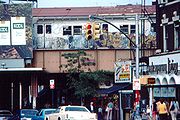
The street is served by three New York City Subway
New York City Subway
The New York City Subway is a rapid transit system owned by the City of New York and leased to the New York City Transit Authority, a subsidiary agency of the Metropolitan Transportation Authority and also known as MTA New York City Transit...
Lines:
- BMT Sea Beach LineBMT Sea Beach LineThe BMT Sea Beach Line is a rapid transit line of the BMT division of the New York City Subway, connecting the BMT Fourth Avenue Line subway at 59th Street via a four-track wide open cut to Coney Island in Brooklyn...
( train), at West 8th Street - IND Culver LineIND Culver LineThe IND Culver Line is a rapid transit line of the B Division of the New York City Subway, extending from Downtown Brooklyn south to Coney Island, Brooklyn, New York City, United States...
( train), at McDonald Ave. - BMT Brighton LineBMT Brighton LineThe BMT Brighton Line is a rapid transit line of the B Division of the New York City Subway in Brooklyn, New York City, United States. Local service is provided at all times by the Q train. The Q is joined by the B express train on weekdays...
( trains), at East 16th Street
See also
- Kings Highway's subway stations
- Avalon TheaterAvalon Theater (Brooklyn)The Avalon Theater was a now defunct theater that opened in Brooklyn, New York on January 25, 1928 and was located on Kings Highway at the northwest corner of East 18th Street in the United States of America....