

King Island, Tasmania
Encyclopedia
King Island is one of the islands that make up the state of Tasmania
, Australia
. It is located in the Roaring Forties
of Bass Strait
, off the north-western tip of the main island of Tasmania, about half way between Tasmania and the mainland state of Victoria
. The southernmost point is called Stokes Point and the northernmost point is called Cape Wickham. There are three small islands surrounding King Island, namely New Year Island
and Christmas Island
situated to the northwest, and a smaller island called Councillor Island
to the east.
King Island was named after Governor King
of New South Wales
, whose territory at the time included what is now Tasmania. The Local Government Area of the island is King Island Council
. The population in 2007 was 1,723.
’ first map of Van Diemen's Land
and Basses Strait
, which was sent to England (before Flinders had left) and was published in June 1800, did not show King Island. However, before Flinders left Sydney for England in 1800, Reed had informed Flinders of the existence of the island. Flinders’ second map of Van Diemen’s Land and Bass’s Strait (properly finished on route to England) and published with his Observations in 1801 shows:
Captain John Black also visited the island just after Reed and named it King's Island after Governor Philip Gidley King
. Captain John Black was sailing in the brig Harbinger, after which the dangerous Harbinger Rocks off the island's north-west coast are named. It was found to abound in both fur seals and elephant seals which were soon exploited to local extinction.
Governor King
, knowing that the French navigator Nicolas Baudin
was going to head for the island, when he left Port Jackson
in 1800, sent the Cumberland from Sydney to formally claim the islands for Britain. The Cumberland arrived just before the French and the British had hastily erected the British Flag in a tree.
As a result of this incident, British settlements were established at the River Derwent
and Port Dalrymple in Tasmania and later Port Phillip
.
Sealers continued to harvest the island intermittently until the mid 1820s, after which the only inhabitants were some old sealers and their Australian aboriginal wives who mostly hunted wallaby
for skins. The last of these left the island in 1854 and for many years it was only occasionally visited by hunters and more often castaways from shipwrecks.
The first submarine communications cable
across Bass Strait in 1859 went via King Island, starting at Cape Otway
, Victoria
, it made contact with the Tasmanian mainland at Stanley Head
, and then continued on to George Town
. However it started failing within a few weeks of completion, and by 1861 it failed completely. A later telephone and telegraph cable across Bass Strait operated via King Island from 1936 until 1963.
In the 1880s the land was opened for grazing. A township developed at Currie
and the Post Office opened on 1 June 1892 (known as King's Island until 1903, King Island until 1917, thereafter Currie).
Currie, on the west coast, now has the only Post Office on the island, but in the past Grassy
, in the southeast (1918–1935, 1943–1991), Naracoopa on the east coast (1920–1962), Pearshape to the south (1946–1959) and Egg Lagoon in the north (1925–1967) (replacing Yambacoona (1922–1925)) all had official Post Offices. The other localities of King Island are Bungaree, Loorana, Lymwood, Nugara, Pegarah, Reekara, Sea Elephant, Surprise Bay, Wickham and Yarra Creek. All share the postcode 7256.
 Situated in the centre of the western entrance to Bass Strait
, King Island has been the location of over 60 known ship wrecks, involving the loss of over 2,000 lives. Many King Islanders are descendants of shipwreck survivors. Notable shipwrecks include:
 The largest town is Currie
, situated on the western side of the island. Grassy township, in the east, was a thriving mining town, where scheelite
was extracted from an open cut mine. After the mine closed in 1990, the mine site was rehabilitated, the town sold and the pit was allowed to flood. Since then the Grassy population has increased and consists of local families, Sea-changers, a campus of Ballarat & Clarendon College and holiday makers. The town now boasts a large, heated indoor Swimming Pool, laundromat, the Grassy Harbour Supermarket, King's Cuisine at the Grassy Club, the Grassy Grub Fish Cafe, the Grassy Emporium, E J Motors and Fuel, Kelp Craft and King Island Holiday Village, for accommodation in the town, and a bed & breakfast and art gallery at the Portside Links, near the harbour. Grassy is also known for the penguin rookery near the port (safe harbour) and platypus at the Upper Grassy Dam. The weekly ferry from Melbourne which services the island comes in to Grassy Harbour on Sundays.
The island is noted for its production of cheese
, lobster
s, bottled rain water, kelp
, and beef
. It is a safe harbour for passing yachts and the site of the Huxley Hill Wind Farm
operated by Hydro Tasmania
.
The island has a football
competition, The King Island Football Association
with just three teams, Currie, Grassy and North, competes annually in the Stonehaven Cup boat races, the Imperial 20-foot race, Queen's Birthday Weekend Pheasant Season and many other activities.
was endemic to the island. Although numerous bones have been found, the only existing skin was collected by Nicolas Baudin
in 1802, shortly before the species became extinct, probably as a result of hunting by sealers
for food.
Some 193 km2 of the island, consisting of the coastline in a strip extending from the low water mark to one kilometre inland of the high water mark around the entire island, with a broader area encompassing Lavinia State Reserve in the north-east, has been identified by BirdLife International
as an Important Bird Area
(IBA). The main feature making it an IBA is that it supports large proportion of the small population of critically endangered
Orange-bellied Parrot
s on their migration route between their breeding grounds in south-western Tasmania and their wintering grounds in mainland south-eastern Australia.
The IBA includes the nearby Christmas
, New Year
and Councillor Island
s which support breeding seabird
s and wader
s. The IBA supports significant numbers of Hooded Plover
s, Flame Robin
s and Fairy Tern
s, over 1% of the world populations of Short-tailed Shearwater
s, Pied
and Sooty Oystercatcher
s, Black-faced Cormorant
s and Pacific Gull
s, as well as populations of ten bird species endemic to Tasmania, including seven subspecies
endemic to King Island.
Tasmania
Tasmania is an Australian island and state. It is south of the continent, separated by Bass Strait. The state includes the island of Tasmania—the 26th largest island in the world—and the surrounding islands. The state has a population of 507,626 , of whom almost half reside in the greater Hobart...
, Australia
Australia
Australia , officially the Commonwealth of Australia, is a country in the Southern Hemisphere comprising the mainland of the Australian continent, the island of Tasmania, and numerous smaller islands in the Indian and Pacific Oceans. It is the world's sixth-largest country by total area...
. It is located in the Roaring Forties
Roaring Forties
The Roaring Forties is the name given to strong westerly winds found in the Southern Hemisphere, generally between the latitudes of 40 and 49 degrees. Air displaced from the Equator towards the South Pole, which travels close to the surface between the latitudes of 30 and 60 degrees south, combines...
of Bass Strait
Bass Strait
Bass Strait is a sea strait separating Tasmania from the south of the Australian mainland, specifically the state of Victoria.-Extent:The International Hydrographic Organization defines the limits of the Bass Strait as follows:...
, off the north-western tip of the main island of Tasmania, about half way between Tasmania and the mainland state of Victoria
Victoria (Australia)
Victoria is the second most populous state in Australia. Geographically the smallest mainland state, Victoria is bordered by New South Wales, South Australia, and Tasmania on Boundary Islet to the north, west and south respectively....
. The southernmost point is called Stokes Point and the northernmost point is called Cape Wickham. There are three small islands surrounding King Island, namely New Year Island
New Year Island (Tasmania)
New Year Island is an island game reserve with an area of 98.22 ha, in south-eastern Australia. It is part of Tasmania’s New Year Island Group which includes the much larger King Island, lying north-west of Tasmania in Bass Strait...
and Christmas Island
Christmas Island (Tasmania)
Christmas Island is an island nature reserve, with an area of 63.49 ha, in south-eastern Australia. It is part of Tasmania’s New Year Island Group which includes the much larger King Island, lying north-west of Tasmania in Bass Strait...
situated to the northwest, and a smaller island called Councillor Island
Councillor Island
Councillor Island is an island with an area of 10.53 ha, in south-eastern Australia. It is part of Tasmania’s New Year Island Group, which includes the much larger King Island, lying north-west of Tasmania in Bass Strait...
to the east.
King Island was named after Governor King
Philip Gidley King
Captain Philip Gidley King RN was a British naval officer and colonial administrator. He is best known as the official founder of the first European settlement on Norfolk Island and as the third Governor of New South Wales.-Early years and establishment of Norfolk Island settlement:King was born...
of New South Wales
New South Wales
New South Wales is a state of :Australia, located in the east of the country. It is bordered by Queensland, Victoria and South Australia to the north, south and west respectively. To the east, the state is bordered by the Tasman Sea, which forms part of the Pacific Ocean. New South Wales...
, whose territory at the time included what is now Tasmania. The Local Government Area of the island is King Island Council
King Island Council
King Island Council is a Local Government Area of Tasmania. It covers the whole of King Island in Bass Strait.-External links:*...
. The population in 2007 was 1,723.
History
King Island was discovered by Captain Reed, hunting seals in the schooner Martha in 1799. Matthew FlindersMatthew Flinders
Captain Matthew Flinders RN was one of the most successful navigators and cartographers of his age. In a career that spanned just over twenty years, he sailed with Captain William Bligh, circumnavigated Australia and encouraged the use of that name for the continent, which had previously been...
’ first map of Van Diemen's Land
Van Diemen's Land
Van Diemen's Land was the original name used by most Europeans for the island of Tasmania, now part of Australia. The Dutch explorer Abel Tasman was the first European to land on the shores of Tasmania...
and Basses Strait
Bass Strait
Bass Strait is a sea strait separating Tasmania from the south of the Australian mainland, specifically the state of Victoria.-Extent:The International Hydrographic Organization defines the limits of the Bass Strait as follows:...
, which was sent to England (before Flinders had left) and was published in June 1800, did not show King Island. However, before Flinders left Sydney for England in 1800, Reed had informed Flinders of the existence of the island. Flinders’ second map of Van Diemen’s Land and Bass’s Strait (properly finished on route to England) and published with his Observations in 1801 shows:
“Land of considerable extent has been seen about this situation”.
Captain John Black also visited the island just after Reed and named it King's Island after Governor Philip Gidley King
Philip Gidley King
Captain Philip Gidley King RN was a British naval officer and colonial administrator. He is best known as the official founder of the first European settlement on Norfolk Island and as the third Governor of New South Wales.-Early years and establishment of Norfolk Island settlement:King was born...
. Captain John Black was sailing in the brig Harbinger, after which the dangerous Harbinger Rocks off the island's north-west coast are named. It was found to abound in both fur seals and elephant seals which were soon exploited to local extinction.
Governor King
Philip Gidley King
Captain Philip Gidley King RN was a British naval officer and colonial administrator. He is best known as the official founder of the first European settlement on Norfolk Island and as the third Governor of New South Wales.-Early years and establishment of Norfolk Island settlement:King was born...
, knowing that the French navigator Nicolas Baudin
Nicolas Baudin
Nicolas-Thomas Baudin was a French explorer, cartographer, naturalist and hydrographer.Baudin was born a commoner in Saint-Martin-de-Ré on the Île de Ré. At the age of fifteen he joined the merchant navy, and at twenty joined the French East India Company...
was going to head for the island, when he left Port Jackson
Port Jackson
Port Jackson, containing Sydney Harbour, is the natural harbour of Sydney, Australia. It is known for its beauty, and in particular, as the location of the Sydney Opera House and Sydney Harbour Bridge...
in 1800, sent the Cumberland from Sydney to formally claim the islands for Britain. The Cumberland arrived just before the French and the British had hastily erected the British Flag in a tree.
As a result of this incident, British settlements were established at the River Derwent
Derwent River (Tasmania)
The Derwent is a river in Tasmania, Australia. It was named after the River Derwent, Cumbria by British Commodore John Hayes who explored it in 1793. The name is Brythonic Celtic for "valley thick with oaks"....
and Port Dalrymple in Tasmania and later Port Phillip
Port Phillip
Port Phillip Port Phillip Port Phillip (also commonly referred to as Port Phillip Bay or (locally) just The Bay, is a large bay in southern Victoria, Australia; it is the location of Melbourne. Geographically, the bay covers and the shore stretches roughly . Although it is extremely shallow for...
.
Sealers continued to harvest the island intermittently until the mid 1820s, after which the only inhabitants were some old sealers and their Australian aboriginal wives who mostly hunted wallaby
Wallaby
A wallaby is any of about thirty species of macropod . It is an informal designation generally used for any macropod that is smaller than a kangaroo or wallaroo that has not been given some other name.-Overview:...
for skins. The last of these left the island in 1854 and for many years it was only occasionally visited by hunters and more often castaways from shipwrecks.
The first submarine communications cable
Submarine communications cable
A submarine communications cable is a cable laid on the sea bed between land-based stations to carry telecommunication signals across stretches of ocean....
across Bass Strait in 1859 went via King Island, starting at Cape Otway
Cape Otway
Cape Otway is a cape in south Victoria, Australia on the Great Ocean Road; much of the area is enclosed in the Otway National Park.-History:...
, Victoria
Victoria (Australia)
Victoria is the second most populous state in Australia. Geographically the smallest mainland state, Victoria is bordered by New South Wales, South Australia, and Tasmania on Boundary Islet to the north, west and south respectively....
, it made contact with the Tasmanian mainland at Stanley Head
Stanley, Tasmania
Stanley is a town on the north-west coast of Tasmania, Australia. Travelling west, Stanley is the second-last major township on the north-west coast of Tasmania, Smithton being the larger township in the Circular Head municipality...
, and then continued on to George Town
George Town, Tasmania
George Town is one of the larger towns in north-east Tasmania, on the eastern bank of the mouth of the Tamar River. At the 2006 census, George Town had a population of 4,266. It is the regional centre of the George Town Council Local Government Area....
. However it started failing within a few weeks of completion, and by 1861 it failed completely. A later telephone and telegraph cable across Bass Strait operated via King Island from 1936 until 1963.
In the 1880s the land was opened for grazing. A township developed at Currie
Currie, Tasmania
Currie is the largest township on King Island, Tasmania, at the western entrance to Bass Strait. At the 2006 census, Currie had a population of 746.-Geography:...
and the Post Office opened on 1 June 1892 (known as King's Island until 1903, King Island until 1917, thereafter Currie).
Currie, on the west coast, now has the only Post Office on the island, but in the past Grassy
Grassy, Tasmania
Grassy, Tasmania, Australia is nearly a ghost town on King Island in the Australian state of Tasmania. The highest population census in Grassy was at 767 people, in 1971. At the 2006 census, Grassy had a population of 219....
, in the southeast (1918–1935, 1943–1991), Naracoopa on the east coast (1920–1962), Pearshape to the south (1946–1959) and Egg Lagoon in the north (1925–1967) (replacing Yambacoona (1922–1925)) all had official Post Offices. The other localities of King Island are Bungaree, Loorana, Lymwood, Nugara, Pegarah, Reekara, Sea Elephant, Surprise Bay, Wickham and Yarra Creek. All share the postcode 7256.
Shipwrecks
Bass Strait
Bass Strait is a sea strait separating Tasmania from the south of the Australian mainland, specifically the state of Victoria.-Extent:The International Hydrographic Organization defines the limits of the Bass Strait as follows:...
, King Island has been the location of over 60 known ship wrecks, involving the loss of over 2,000 lives. Many King Islanders are descendants of shipwreck survivors. Notable shipwrecks include:
- 1801, large unidentified three-masted full rigged shipFull rigged shipA full rigged ship or fully rigged ship is a sailing vessel with three or more masts, all of them square rigged. A full rigged ship is said to have a ship rig....
, probably a whaler. No survivors known. - 1835, NevaNeva (ship)The Neva was a three-masted barque that as a convict ship was wrecked in Bass Strait on 13 May 1835. One of the worst shipwrecks in Australian history, 224 lives were lost.-Origins of the Neva:...
, convict shipConvict shipThe term convict ship is a colloquial term used to describe any ship engaged on a voyage to carry convicted felons under sentence of penal transportation from their place of conviction to their place of exile.-Colonial practice:...
327 tons, 225 lives lost. - 1840, Isabella, full-rigged ship 287 tons, no lives lost.
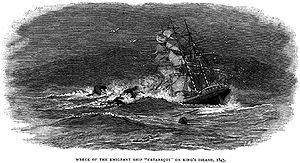
- 1845, Cataraqui, full-rigged ship 802 tons, 400 lives lost.
- 1854, Brahmin, full-rigged ship 616 tons, 17 lives lost.
- 1854, Waterwitch, schoonerSchoonerA schooner is a type of sailing vessel characterized by the use of fore-and-aft sails on two or more masts with the forward mast being no taller than the rear masts....
134 tons, no lives lost. - 1855, Whistler, American clipper ship, 942 tons, two lives lost.
- 1855, Maypo, brigBrigA brig is a sailing vessel with two square-rigged masts. During the Age of Sail, brigs were seen as fast and manoeuvrable and were used as both naval warships and merchant vessels. They were especially popular in the 18th and early 19th centuries...
174 tons, no lives lost. - 1865, Arrow, schooner 166 tons, one life lost.
- 1866, NetherbyNetherby (ship)The Netherby was a full rigged sailing ship of the Black Ball Line that ran aground and sank off the coast of King Island—an island in Bass Strait between Tasmania and the Australian mainland—on 23 July 1866 while sailing from London to Brisbane.Remarkably, all of the 413 passengers...
, full-rigged ship 944 tons, no lives lost. - 1871, Loch Leven, iron clipper ship 1868 tons, one life lost.
- 1874, British Admiral, iron clipper ship, 79 lives lost.
- 1875, Blencathra, iron barque, 933 tons, no lives lost.
- 1910, Carnarvon Bay, steel full-rigged ship 1932 tons, no loss of life.
The island today
Currie, Tasmania
Currie is the largest township on King Island, Tasmania, at the western entrance to Bass Strait. At the 2006 census, Currie had a population of 746.-Geography:...
, situated on the western side of the island. Grassy township, in the east, was a thriving mining town, where scheelite
Scheelite
Scheelite is a calcium tungstate mineral with the chemical formula CaWO4. It is an important ore of tungsten. Well-formed crystals are sought by collectors and are occasionally fashioned into gemstones when suitably free of flaws...
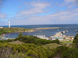
was extracted from an open cut mine. After the mine closed in 1990, the mine site was rehabilitated, the town sold and the pit was allowed to flood. Since then the Grassy population has increased and consists of local families, Sea-changers, a campus of Ballarat & Clarendon College and holiday makers. The town now boasts a large, heated indoor Swimming Pool, laundromat, the Grassy Harbour Supermarket, King's Cuisine at the Grassy Club, the Grassy Grub Fish Cafe, the Grassy Emporium, E J Motors and Fuel, Kelp Craft and King Island Holiday Village, for accommodation in the town, and a bed & breakfast and art gallery at the Portside Links, near the harbour. Grassy is also known for the penguin rookery near the port (safe harbour) and platypus at the Upper Grassy Dam. The weekly ferry from Melbourne which services the island comes in to Grassy Harbour on Sundays.
The island is noted for its production of cheese
Cheese
Cheese is a generic term for a diverse group of milk-based food products. Cheese is produced throughout the world in wide-ranging flavors, textures, and forms....
, lobster
Lobster
Clawed lobsters comprise a family of large marine crustaceans. Highly prized as seafood, lobsters are economically important, and are often one of the most profitable commodities in coastal areas they populate.Though several groups of crustaceans are known as lobsters, the clawed lobsters are most...
s, bottled rain water, kelp
Kelp
Kelps are large seaweeds belonging to the brown algae in the order Laminariales. There are about 30 different genera....
, and beef
Beef
Beef is the culinary name for meat from bovines, especially domestic cattle. Beef can be harvested from cows, bulls, heifers or steers. It is one of the principal meats used in the cuisine of the Middle East , Australia, Argentina, Brazil, Europe and the United States, and is also important in...
. It is a safe harbour for passing yachts and the site of the Huxley Hill Wind Farm
Huxley Hill Wind Farm, Tasmania
Huxley Hill Wind Farm is a wind power station at King Island, Tasmania, Australia, of around 1600 residents, owned by Hydro Tasmania, which supplements the four diesel generators with a combined capacity of 6 MW at Currie Power Station...
operated by Hydro Tasmania
Hydro Tasmania
Hydro Tasmania, known for most of its history as The HEC, is the government owned enterprise which is the predominant electricity generator in the state of Tasmania, Australia...
.
The island has a football
Australian rules football
Australian rules football, officially known as Australian football, also called football, Aussie rules or footy is a sport played between two teams of 22 players on either...
competition, The King Island Football Association
King Island Football Association
The King Island Football Association is an Australian rules football competition held in Tasmania, Australia. Three clubs from small communities on King Island compete for the premiership every year.-History:...
with just three teams, Currie, Grassy and North, competes annually in the Stonehaven Cup boat races, the Imperial 20-foot race, Queen's Birthday Weekend Pheasant Season and many other activities.
Birds
The King Island EmuKing Island Emu
The King Island Emu or Black Emu is an extinct sub-species of emu which occurred on King Island between mainland Australia and Tasmania. It is known from 19th century descriptions of live birds, as well as subfossil bones and one museum specimen...
was endemic to the island. Although numerous bones have been found, the only existing skin was collected by Nicolas Baudin
Nicolas Baudin
Nicolas-Thomas Baudin was a French explorer, cartographer, naturalist and hydrographer.Baudin was born a commoner in Saint-Martin-de-Ré on the Île de Ré. At the age of fifteen he joined the merchant navy, and at twenty joined the French East India Company...
in 1802, shortly before the species became extinct, probably as a result of hunting by sealers
Seal hunting
Seal hunting, or sealing, is the personal or commercial hunting of seals. The hunt is currently practiced in five countries: Canada, where most of the world's seal hunting takes place, Namibia, the Danish region of Greenland, Norway and Russia...
for food.
Some 193 km2 of the island, consisting of the coastline in a strip extending from the low water mark to one kilometre inland of the high water mark around the entire island, with a broader area encompassing Lavinia State Reserve in the north-east, has been identified by BirdLife International
BirdLife International
BirdLife International is a global Partnership of conservation organisations that strives to conserve birds, their habitats and global biodiversity, working with people towards sustainability in the use of natural resources...
as an Important Bird Area
Important Bird Area
An Important Bird Area is an area recognized as being globally important habitat for the conservation of bird populations. Currently there are about 10,000 IBAs worldwide. The program was developed and sites are identified by BirdLife International...
(IBA). The main feature making it an IBA is that it supports large proportion of the small population of critically endangered
Critically endangered
Version 2010.3 of the IUCN Red List of Threatened Species identified 3744 Critically Endangered species, subspecies and varieties, stocks and subpopulations.Critically Endangered by kingdom:*1993 Animalia*2 Fungi*1745 Plantae*4 Protista-References:...
Orange-bellied Parrot
Orange-bellied Parrot
The Orange-bellied Parrot is a small broad-tailed parrot endemic to southern Australia, and one of only two species of parrot which migrate. The adult male is distinguished by its bright grass-green upperparts, yellow underparts and orange belly patch. The adult female and juvenile are duller...
s on their migration route between their breeding grounds in south-western Tasmania and their wintering grounds in mainland south-eastern Australia.
The IBA includes the nearby Christmas
Christmas Island (Tasmania)
Christmas Island is an island nature reserve, with an area of 63.49 ha, in south-eastern Australia. It is part of Tasmania’s New Year Island Group which includes the much larger King Island, lying north-west of Tasmania in Bass Strait...
, New Year
New Year Island (Tasmania)
New Year Island is an island game reserve with an area of 98.22 ha, in south-eastern Australia. It is part of Tasmania’s New Year Island Group which includes the much larger King Island, lying north-west of Tasmania in Bass Strait...
and Councillor Island
Councillor Island
Councillor Island is an island with an area of 10.53 ha, in south-eastern Australia. It is part of Tasmania’s New Year Island Group, which includes the much larger King Island, lying north-west of Tasmania in Bass Strait...
s which support breeding seabird
Seabird
Seabirds are birds that have adapted to life within the marine environment. While seabirds vary greatly in lifestyle, behaviour and physiology, they often exhibit striking convergent evolution, as the same environmental problems and feeding niches have resulted in similar adaptations...
s and wader
Wader
Waders, called shorebirds in North America , are members of the order Charadriiformes, excluding the more marine web-footed seabird groups. The latter are the skuas , gulls , terns , skimmers , and auks...
s. The IBA supports significant numbers of Hooded Plover
Hooded Plover
The Hooded Dotterel or Hooded Plover is a species of bird in the Charadriidae family. It is endemic to southern Australia and Tasmania. There are two recognized subspecies, both of which are classifed as Endangered....
s, Flame Robin
Flame Robin
The Flame Robin is a small passerine bird native to Australia. It is a moderately common resident of the coolest parts of south-eastern Australia, including Tasmania. Like the other two red-breasted Petroica robins—the Scarlet Robin and the Red-capped Robin—it is often simply but...
s and Fairy Tern
Fairy Tern
The Fairy Tern is a small tern which occurs in the southwestern Pacific.There are three subspecies:* Australian Fairy Tern, Sterna nereis nereis - breeds in Australia...
s, over 1% of the world populations of Short-tailed Shearwater
Short-tailed Shearwater
The Short-tailed Shearwater or Slender-billed Shearwater , also called Yolla or Moonbird, and commonly known as the muttonbird in Australia, is the most abundant seabird species in Australian waters, and is one of the few Australian native birds in which the chicks are commercially harvested...
s, Pied
Pied Oystercatcher
The Pied Oystercatcher, Haematopus longirostris, is a species of oystercatcher. It is a wading bird native to Australia and commonly found on its coastline. The similar South Island Pied Oystercatcher The Pied Oystercatcher, Haematopus longirostris, is a species of oystercatcher. It is a wading...
and Sooty Oystercatcher
Sooty Oystercatcher
The Sooty Oystercatcher, Haematopus fuliginosus, is a species of oystercatcher. It is a wading bird native to Australia and commonly found on its coastline. It prefers rocky coastlines, but will occasionally live in estuaries....
s, Black-faced Cormorant
Black-faced Cormorant
The Black-faced Cormorant , also known as the Black-faced Shag, is a medium-sized member of the cormorant family. Upperparts, including facial skin and bill, are black, with white underparts. It is endemic to coastal regions of southern Australia.-Ecology:The Black-faced-Cormorant feeds largely on...
s and Pacific Gull
Pacific Gull
The Pacific Gull is a very large gull, native to the coasts of Australia. It is moderately common between Carnarvon in the west, and Sydney in the east, although it has become scarce in some parts of the south-east, as a result of competition from the Kelp Gull, which has "self-introduced" since...
s, as well as populations of ten bird species endemic to Tasmania, including seven subspecies
Subspecies
Subspecies in biological classification, is either a taxonomic rank subordinate to species, ora taxonomic unit in that rank . A subspecies cannot be recognized in isolation: a species will either be recognized as having no subspecies at all or two or more, never just one...
endemic to King Island.
Climate
See also
- Huxley Hill Wind FarmHuxley Hill Wind Farm, TasmaniaHuxley Hill Wind Farm is a wind power station at King Island, Tasmania, Australia, of around 1600 residents, owned by Hydro Tasmania, which supplements the four diesel generators with a combined capacity of 6 MW at Currie Power Station...
- King Island AirportKing Island AirportKing Island Airport is a small regional airport located near the town of Currie on King Island off the north-west coast of Tasmania, Australia. The airport is owned and operated by the King Island Council.-Incidents and accidents:...
- New Year Island (Tasmania)New Year Island (Tasmania)New Year Island is an island game reserve with an area of 98.22 ha, in south-eastern Australia. It is part of Tasmania’s New Year Island Group which includes the much larger King Island, lying north-west of Tasmania in Bass Strait...
- Christmas Island (Tasmania)Christmas Island (Tasmania)Christmas Island is an island nature reserve, with an area of 63.49 ha, in south-eastern Australia. It is part of Tasmania’s New Year Island Group which includes the much larger King Island, lying north-west of Tasmania in Bass Strait...
- Councillor IslandCouncillor IslandCouncillor Island is an island with an area of 10.53 ha, in south-eastern Australia. It is part of Tasmania’s New Year Island Group, which includes the much larger King Island, lying north-west of Tasmania in Bass Strait...
- King Island Football AssociationKing Island Football AssociationThe King Island Football Association is an Australian rules football competition held in Tasmania, Australia. Three clubs from small communities on King Island compete for the premiership every year.-History:...