Kilbourne Hole
Encyclopedia
Maar
A maar is a broad, low-relief volcanic crater that is caused by a phreatomagmatic eruption, an explosion caused by groundwater coming into contact with hot lava or magma. A maar characteristically fills with water to form a relatively shallow crater lake. The name comes from the local Moselle...
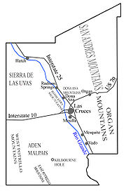
volcanic crater, located 30 miles (48.3 km) west of the Franklin mountains of El Paso, Texas
El Paso, Texas
El Paso, is a city in and the county seat of El Paso County, Texas, United States, and lies in far West Texas. In the 2010 census, the city had a population of 649,121. It is the sixth largest city in Texas and the 19th largest city in the United States...
, in the Potrillo Volcanic Field
Potrillo volcanic field
The Potrillo Volcanic Field is a monogenetic volcanic field located on the Rio Grande Rift, in a portion of its rift valley, in southern New Mexico, USA and northern Chihuahua, Mexico...
of Doña Ana County, New Mexico
Doña Ana County, New Mexico
-2010:Whereas according to the 2010 U.S. Census Bureau:*74.1% White*1.7% Black*1.5% Native American*1.1% Asian*0.1% Native Hawaiian or Pacific Islander*3.0% Two or more races*18.5% Other races*65.7% Hispanic or Latino -2000:...
. Nearby Hunt's Hole lies several miles just south of Kilbourne Hole. These holes are rare examples of volcanic action without a mountainous rim. The theory of formation is that a volcanic eruption occurs in the presence of groundwater, beneath the surface of the earth. As the magma encounters the groundwater, explosive interactions occur. Country rocks
Country rock (geology)
Country rock is a geological term meaning the rock native to an area. It is similar and in many cases interchangeable with the terms basement and wall rocks....
are fragmented and expelled in the atmosphere (together with fragments of the magma
Magma
Magma is a mixture of molten rock, volatiles and solids that is found beneath the surface of the Earth, and is expected to exist on other terrestrial planets. Besides molten rock, magma may also contain suspended crystals and dissolved gas and sometimes also gas bubbles. Magma often collects in...
), eventually creating a deep crater, the bottom of which sits below the pre-eruptive ground surface. The crater is thought to be 80,000 years old.
The volcanic features around El Paso and vicinity are part of the Rio Grande rift
Rio Grande Rift
The Rio Grande Rift is a north-trending continental rift zone. It separates the Colorado Plateau in the west from the interior of the North American craton on the east. The rift extends from central Colorado in the north to the state of Chihuahua, Mexico in the south. The rift zone consists of four...
, which extends northward into Colorado
Colorado
Colorado is a U.S. state that encompasses much of the Rocky Mountains as well as the northeastern portion of the Colorado Plateau and the western edge of the Great Plains...
.
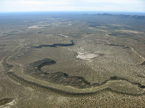
Description of the crater
- Latitude/Longitude: 31°58′19"N 106°57′53"W
- Elevation: 4,239 feet (1,292 m)
- Crater diameter: 1.5x2.1 miles (2.4x3.4 km)
- Depth: 443 feet (135 m)
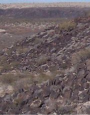
The hole is over a mile wide, and over 300 feet (91.4 m) deep. Two basalt
Basalt
Basalt is a common extrusive volcanic rock. It is usually grey to black and fine-grained due to rapid cooling of lava at the surface of a planet. It may be porphyritic containing larger crystals in a fine matrix, or vesicular, or frothy scoria. Unweathered basalt is black or grey...
cliffs inside the crater, with the characteristic reddish purple hexagonal columns, occupy the northeast and southeast sides of the crater. The cliffs are about 40 feet (12.2 m) high. Layers of ashfall and crumbling sediment
Sediment
Sediment is naturally occurring material that is broken down by processes of weathering and erosion, and is subsequently transported by the action of fluids such as wind, water, or ice, and/or by the force of gravity acting on the particle itself....
also rise about 40 feet (12.2 m) high, on the south rim of the crater. This ashfall section will not support your weight, on the south rim; it is safer to stay on the basalt cliffs and the sand dunes. Sand dunes have collected on the east side of the crater, rising about 100 feet (30.5 m) above the desert floor. A dry lakebed lies on the floor of the crater.
The basalt cliffs resemble the cliffs of the Devils Postpile National Monument
Devils Postpile National Monument
Devils Postpile National Monument is located near Mammoth Mountain in extreme northeastern Madera County in eastern California. It was established in 1911, and protects Devils Postpile, an unusual formation of columnar basalt.-Geography:...
near Yosemite National Park
Yosemite National Park
Yosemite National Park is a United States National Park spanning eastern portions of Tuolumne, Mariposa and Madera counties in east central California, United States. The park covers an area of and reaches across the western slopes of the Sierra Nevada mountain chain...
, except that they are not as tall.
Rockhounds can pick up the green peridot variety of the mineral species forsterite, part of the Olivine
Olivine
The mineral olivine is a magnesium iron silicate with the formula 2SiO4. It is a common mineral in the Earth's subsurface but weathers quickly on the surface....
group of minerals, which are available at few places on earth, such as St John's Island in the Red Sea, Pakistan, Sri Lanka, Ethiopia, Hawaii, Arizona and the Monte Somma-Vesuvius Complex in Italy.
Lava
Lava
Lava refers both to molten rock expelled by a volcano during an eruption and the resulting rock after solidification and cooling. This molten rock is formed in the interior of some planets, including Earth, and some of their satellites. When first erupted from a volcanic vent, lava is a liquid at...
chunks exist in abundance. The basalt column fragments are each larger than a person.
Apollo astronauts trained in these craters in 1969.
Directions to Kilbourne and Hunt's Holes
Note: Kilbourne Hole is one of the few places world-wide where mantle xenoliths can be collected at the surface. These xenoliths are critical to petrologists and geophysicists for establishing the exact nature of the earth below the easily sampled crust. For this reason, visitors are encouraged to "look but don't touch". Please don't collect samples of the ultramafic rocks simply for the sake of owning one as there is a limited supply.Because there is new road-building at the southern end of Doña Ana county, the existing published descriptions are out of date. Compiled here is a description gained by interviewing local residents who gave accurate directions, from their own experience:
- Mile 0.0: Head west on Texas 375 from the intersection of Interstate-10 and Texas State Highway, Loop 375 exit (Trans-Mountain Road) toward Canutillo, Texas.
- Mile 1.0: Head north to Texas 20, the main road of Canutillo, until La Mesa road crosses it.
- Mile 1.7: Head west on La Mesa road, crossing the Rio Grande. This road becomes Texas 259 (La Union - Canutillo road).
- Mile 2.6: Texas 259 becomes New Mexico 28 at the state line. Keep heading west.
- Mile 3.0: Follow NM 28 west until it veers north. Head west at the intersection of NM 28 and NM 273 (McNutt Road) This is McNutt Road, the major road of the county, travelling roughly parallel to the course of the Rio Grande. You will be driving through pecanPecanThe pecan , Carya illinoinensis, is a species of hickory, native to south-central North America, in Mexico from Coahuila south to Jalisco and Veracruz, in the United States from southern Iowa, Illinois, Missouri, and Indiana east to western Kentucky, southwestern Ohio, North Carolina, South...
orchards and cottonCottonCotton is a soft, fluffy staple fiber that grows in a boll, or protective capsule, around the seeds of cotton plants of the genus Gossypium. The fiber is almost pure cellulose. The botanical purpose of cotton fiber is to aid in seed dispersal....
fields. - Mile 5.1: Follow McNutt west to La Union, where McNutt veers south. At this turn of McNutt, turn north on Alvarez and follow Alvarez north through La Union.
- Mile 7.9: You will pass the Mercantile road, La Union road on the way through La Union.
- Mile 8.2: Pavement ends on Alvarez at Short St. Continue north (left fork) on Alvarez, a dirt road. Don't take El Chavo, a gravel road.
- Mile 8.4: Alvarez will continue northward, but a fork westward, labelled County A-20 will head over the sand bluffs which rise 50 feet (15.2 m) above the Rio Grande flood plain. Take A-20 west.
- Mile 10.0: Top of the sand bluff above the Rio Grande.
- Mile 10.4: Water tank on the northeast side of A20
- Mile 11.7: At the top of the rise there is a cattle guard. Keep heading west on this unpaved road.
- Mile 14.8: Follow the graded road to two cattle guards which surround a crossing of the Union-Pacific railroad line, which runs from El Paso through New Mexico and westward. Cross over the first cattle guard, the railroad track, and the second cattle guard.
- Mile 15.1: Immediately after the second cattle guard, take the graded road northwestward. This road runs parallel to the railroad line.
- Mile 15.5: The graded road hits a cattle guard at County Road 014, heading west. Turn west onto Road 014. Kilbourne hole and Hunt's hole are west 12 miles (19.3 km). Fall and Winter are the best times to visit; rattlesnakes are awake during the Summer. Stay on the graded road. The surface is a hard-pan called caliche which stays drivable; apparently the road is maintained for the benefit of the ranchers here.
- Mile 20.3: Cattle guard. Use caution at rises in the road. Even if you were the driving the only car, with a dust trail clearly signalling your position, the dikes of lava in the desert are NOT level. You could roll your car if you drive too rapidly over the lava dikes, which rise 5 feet (1.5 m) from the ordinary desert floor, and possibly hit an oncoming vehicle.
- Mile 25.9: The eastern-most lava dike is 3 miles (4.8 km) from the foot of the crater.
- Mile 26.9: A rise in the land to the north of the road, and a mile from the dike is the eastern lip of the crater. It is a fine walk across the desert to the lip, which is a sand dune which rises 100 feet (30.5 m) above the desert floor.
- Mile 27.4: Alternatively, continue west on Road A014 and take a side road north to the south lip of the crater.
- Mile 27.5: South lip of the crater.
Use caution. You will be completely isolated here. Cell phones are out of range here. Take several gallons of water per person. Wear a hat. Tell others of your plans, and give an estimated time of return. 4WD is not necessary, but a high-clearance vehicle is highly recommended. The road leading down into the crater is not safe - the hardpan will collapse under the weight of your vehicle. In an emergency there is a ranch approximately 3–4 miles to the west. The U.S. Border Patrol is often encountered as well. Do not travel here alone.
To get back to El Paso or Las Cruces, reverse the directions. One can also travel west on A014 until it ends at A008 and then travel south on A008 until reaching the first paved road which is New Mexico Highway 9.
Maps and aerial photos