
Kemsing, Kent
Encyclopedia
Kemsing is a village and civil parish in the Sevenoaks
District of Kent
, England
. The parish lies on the scarp face of the North Downs
, 20 miles south east of Central London
, 4 miles (6 km) north east of Sevenoaks
. Also in the parish are the hamlets of Heaverham
, 1 miles (2 km) to the east, and Noah's Ark 0.5 mile (0.80467 km) to the south. The population of the civil parish in 2001 was 4014 persons.
'Tis mine
Each passing hour to tell.
'Tis thine
To use it ill or well.
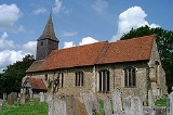
Given the village connection with St. Edith it is perhaps surprising that the parish church, Saxon in origin, is however dedicated to St Mary the Virgin.
Another local legend states that the knights who murdered Archbishop Thomas Becket
rode through Kemsing on their way to seek him out at Canterbury. Following his canonisation Kemsing became a stop-off place on the Pilgrims' Way
, along which pilgrims travelled to visit the saint's shrine at Canterbury Cathedral
.
The Women's Institute organisation opened its first institute in Kent in Kemsing in December 1915.
During the first world war
St Edith Hall was used as a hospital and manned by the Kent Voluntary Aid Detachment. Wounded soldiers from the western front were returned to England and the hall at Kemsing was one of many facilities in the south east of England used during the war.
West End is the location of the two village centre public houses, the Bell and the Wheatsheaf. The Wheatsheaf was recently very badly damaged by a fire; while there were no casualties, the building's roof was lost and the public house is currently a shell. Further to the east at Heaverham
is the Chequers.
One mile (2 km) south-east of the village lies Kemsing railway station
. The M26 motorway
passes through the parish. It is also a key stopping-off point on the North Downs Way
which runs north of the village along the ridge of the Downs.
, and Kemsing Down Reserve, managed by Kemsing Parish Council and Sevenoaks District Council, lies above the village on the North Downs. It is reached from Childsbridge Lane, and is an area of chalk
grassland.
Sevenoaks (district)
Sevenoaks is a local government district covering the western most part of Kent in England. Its council is based in the town of Sevenoaks. It was formed on 1 April 1974, under the Local Government Act 1972, by a merger of the Sevenoaks Urban District, Sevenoaks Rural District and part of Dartford...
District of Kent
Kent
Kent is a county in southeast England, and is one of the home counties. It borders East Sussex, Surrey and Greater London and has a defined boundary with Essex in the middle of the Thames Estuary. The ceremonial county boundaries of Kent include the shire county of Kent and the unitary borough of...
, England
England
England is a country that is part of the United Kingdom. It shares land borders with Scotland to the north and Wales to the west; the Irish Sea is to the north west, the Celtic Sea to the south west, with the North Sea to the east and the English Channel to the south separating it from continental...
. The parish lies on the scarp face of the North Downs
North Downs
The North Downs are a ridge of chalk hills in south east England that stretch from Farnham in Surrey to the White Cliffs of Dover in Kent. The North Downs lie within two Areas of Outstanding Natural Beauty , the Surrey Hills and the Kent Downs...
, 20 miles south east of Central London
Central London
Central London is the innermost part of London, England. There is no official or commonly accepted definition of its area, but its characteristics are understood to include a high density built environment, high land values, an elevated daytime population and a concentration of regionally,...
, 4 miles (6 km) north east of Sevenoaks
Sevenoaks
Sevenoaks is a commuter town situated on the London fringe of west Kent, England, some 20 miles south-east of Charing Cross, on one of the principal commuter rail lines from the capital...
. Also in the parish are the hamlets of Heaverham
Heaverham
Heaverham is a hamlet in the Sevenoaks District, in the county of Kent, England.- Location :It is located about three miles away from the town of Sevenoaks and about a mile away from the large village of Kemsing...
, 1 miles (2 km) to the east, and Noah's Ark 0.5 mile (0.80467 km) to the south. The population of the civil parish in 2001 was 4014 persons.
History
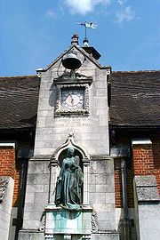
Kemsing was the birthplace, in AD961, of Saint Edith of Wilton, an illegitimate daughter of the Saxon King Edgar I. The well at the centre of the village is dedicated to her, a plaque on the wall recording the local legend that her saintly presence has given the water healing properties. The historic village centre area around the well includes the war memorial, a cluster of picturesque cottages and St. Edith's Hall, the front of which is adorned with a statue of the saint and a clock which chimes the hours and bears the inscription:'Tis mine
Each passing hour to tell.
'Tis thine
To use it ill or well.
Given the village connection with St. Edith it is perhaps surprising that the parish church, Saxon in origin, is however dedicated to St Mary the Virgin.
Another local legend states that the knights who murdered Archbishop Thomas Becket
Thomas Becket
Thomas Becket was Archbishop of Canterbury from 1162 until his murder in 1170. He is venerated as a saint and martyr by both the Roman Catholic Church and the Anglican Communion...
rode through Kemsing on their way to seek him out at Canterbury. Following his canonisation Kemsing became a stop-off place on the Pilgrims' Way
Pilgrims' Way
The Pilgrims' Way is the historic route supposed to have been taken by pilgrims from Winchester in Hampshire, England, to the shrine of Thomas Becket at Canterbury in Kent...
, along which pilgrims travelled to visit the saint's shrine at Canterbury Cathedral
Canterbury Cathedral
Canterbury Cathedral in Canterbury, Kent, is one of the oldest and most famous Christian structures in England and forms part of a World Heritage Site....
.
The Women's Institute organisation opened its first institute in Kent in Kemsing in December 1915.
During the first world war
World War I
World War I , which was predominantly called the World War or the Great War from its occurrence until 1939, and the First World War or World War I thereafter, was a major war centred in Europe that began on 28 July 1914 and lasted until 11 November 1918...
St Edith Hall was used as a hospital and manned by the Kent Voluntary Aid Detachment. Wounded soldiers from the western front were returned to England and the hall at Kemsing was one of many facilities in the south east of England used during the war.
Local infrastructure
The main roads in the village are West End, Dynes Road and Childsbridge Lane. Along West End can be found a mechanic, a general stores, a chemist, a post office, a veterinary surgery and St. Edith's Social Club. At the end of Dynes Road there is a newsagent, a convenience store, three takeaway restaurants and a post office, which are all collectively known as Dynes Parade.West End is the location of the two village centre public houses, the Bell and the Wheatsheaf. The Wheatsheaf was recently very badly damaged by a fire; while there were no casualties, the building's roof was lost and the public house is currently a shell. Further to the east at Heaverham
Heaverham
Heaverham is a hamlet in the Sevenoaks District, in the county of Kent, England.- Location :It is located about three miles away from the town of Sevenoaks and about a mile away from the large village of Kemsing...
is the Chequers.
One mile (2 km) south-east of the village lies Kemsing railway station
Kemsing railway station
Kemsing railway station serves Kemsing in Kent, although the station is actually located on the other side of the M26 motorway to the village. Train services are provided by Southeastern.The station has for many years been unstaffed...
. The M26 motorway
M26 motorway
The M26 is a motorway in Kent, England. It provides a short link between the M25/A21 at Sevenoaks and the M20 near Wrotham.-Route:The motorway starts at junction 3 of the M20 and heads west, encountering almost immediately the single junction along its length where it has an interchange with the A20...
passes through the parish. It is also a key stopping-off point on the North Downs Way
North Downs Way
The North Downs Way is a long-distance path in southern England, opened in 1978. It runs from Farnham to Dover, past Godalming, Guildford, Dorking, Merstham, Otford and Rochester, along the Surrey Hills Area of Outstanding Natural Beauty and Kent Downs AONB.East of Boughton Lees, the path splits...
which runs north of the village along the ridge of the Downs.
Local environment
The village lies in an Area of Outstanding Natural BeautyArea of Outstanding Natural Beauty
An Area of Outstanding Natural Beauty is an area of countryside considered to have significant landscape value in England, Wales or Northern Ireland, that has been specially designated by the Countryside Agency on behalf of the United Kingdom government; the Countryside Council for Wales on...
, and Kemsing Down Reserve, managed by Kemsing Parish Council and Sevenoaks District Council, lies above the village on the North Downs. It is reached from Childsbridge Lane, and is an area of chalk
Chalk
Chalk is a soft, white, porous sedimentary rock, a form of limestone composed of the mineral calcite. Calcite is calcium carbonate or CaCO3. It forms under reasonably deep marine conditions from the gradual accumulation of minute calcite plates shed from micro-organisms called coccolithophores....
grassland.