

Jarbidge Mountains
Encyclopedia
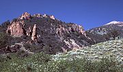
The Jarbidge Mountains are a range of high peaks in northern Elko County
, in northeastern Nevada
in the western United States
. The range extends southward approximately 25 miles (40 km) from a point near the small community of Jarbidge
. To the east is the East Fork of the Jarbidge River, O'Neil Basin, and Salmon Falls Creek
. To the west is Jarbidge itself, the Jarbidge River
, and the Mahogany Mountains. The southern slopes of the Jarbidge Mountains, however, eventually drain into the main branch of the Humboldt River
, and are therefore part of the Great Basin
.
The Jarbidge Mountains, the Mahoganies, and the nearby Independence Mountains
are all part of the Humboldt National Forest. Much of the range is within the Jarbidge Wilderness
, and about 10 miles (16 km) to the west is the Wild Horse State Recreation Area
. The highest point in the range is Matterhorn Peak, at an elevation of 10,839 feet (3305 m). Other major peaks include Marys River Peak (10,565 ft, 3220 m), Cougar Peak (10,559 ft, 3218 m), Square Top Mountain (10,694 ft, 3260 m), Jumbo Peak (10,635 ft, 3240 m), and Jarbidge Peak (10,789 ft, 3290 m). Four miles east of the main crest lies God's Pocket Peak (10,184 ft, 3105 m).
Elko County, Nevada
-Demographics:As of the census of 2000, there were 45,291 people, 15,638 households, and 11,493 families residing in the county. The population density was 3/sq mi . There were 18,456 housing units at an average density of 1/sq mi...
, in northeastern Nevada
Nevada
Nevada is a state in the western, mountain west, and southwestern regions of the United States. With an area of and a population of about 2.7 million, it is the 7th-largest and 35th-most populous state. Over two-thirds of Nevada's people live in the Las Vegas metropolitan area, which contains its...
in the western United States
Western United States
.The Western United States, commonly referred to as the American West or simply "the West," traditionally refers to the region comprising the westernmost states of the United States. Because the U.S. expanded westward after its founding, the meaning of the West has evolved over time...
. The range extends southward approximately 25 miles (40 km) from a point near the small community of Jarbidge
Jarbidge, Nevada
Jarbidge is an unincorporated community in Elko County, Nevada, United States. It lies on the edge of the Jarbidge Wilderness, several miles south of the Idaho/Nevada border. Noted locally for its remoteness, the community is usually accessed by road from Rogerson in Twin Falls County, Idaho...
. To the east is the East Fork of the Jarbidge River, O'Neil Basin, and Salmon Falls Creek
Salmon Falls Creek
Salmon Falls Creek is a tributary of the Snake River, flowing from northern Nevada into Idaho in the United States. Formed in high mountains at the northern edge of the Great Basin, Salmon Falls Creek flows northwards , draining an arid and mountainous basin of...
. To the west is Jarbidge itself, the Jarbidge River
Jarbidge River
The Jarbidge River is a , high altitude river in northern Nevada and southwest Idaho in the United States. The Jarbidge originates as two main forks in the Jarbidge Mountains of northeastern Nevada and then flows through basalt and rhyolite canyons on the high plateau of the Owyhee Desert before...
, and the Mahogany Mountains. The southern slopes of the Jarbidge Mountains, however, eventually drain into the main branch of the Humboldt River
Humboldt River
The Humboldt River runs through northern Nevada in the western United States. At approximately long it is the second longest river in the Great Basin, after the Bear River. It has no outlet to the ocean, but instead empties into the Humboldt Sink...
, and are therefore part of the Great Basin
Great Basin
The Great Basin is the largest area of contiguous endorheic watersheds in North America and is noted for its arid conditions and Basin and Range topography that varies from the North American low point at Badwater Basin to the highest point of the contiguous United States, less than away at the...
.
The Jarbidge Mountains, the Mahoganies, and the nearby Independence Mountains
Independence Mountains
The Independence Mountains are a range of peaks and hills in northern Elko County, in northeastern Nevada in the western United States. The range extends northward approximately from a point near Carlin to the banks of the Owyhee River. To the east is the North Fork of the Humboldt River, and to...
are all part of the Humboldt National Forest. Much of the range is within the Jarbidge Wilderness
Jarbidge Wilderness
The Jarbidge Wilderness is located in the upper elevations of the Jarbidge Mountains in northern Elko County, in northeastern Nevada in the western United States. Established in 1964, it was the first wilderness area in the state...
, and about 10 miles (16 km) to the west is the Wild Horse State Recreation Area
Wild Horse State Recreation Area
Wild Horse State Recreation Area is a state park unit of Nevada, USA, on the northeast shore of Wild Horse Reservoir. Located north of the town of Elko, it is in the Central Nevada Region of Nevada State Parks. The state park is a popular destination for fishing, especially ice fishing, at Wild...
. The highest point in the range is Matterhorn Peak, at an elevation of 10,839 feet (3305 m). Other major peaks include Marys River Peak (10,565 ft, 3220 m), Cougar Peak (10,559 ft, 3218 m), Square Top Mountain (10,694 ft, 3260 m), Jumbo Peak (10,635 ft, 3240 m), and Jarbidge Peak (10,789 ft, 3290 m). Four miles east of the main crest lies God's Pocket Peak (10,184 ft, 3105 m).