
Independence Mountains
Encyclopedia
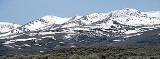
The Independence Mountains are a range of peaks and hills in northern Elko County
, in northeastern Nevada
in the western United States
. The range extends northward approximately 70 mi (112.7 km) from a point near Carlin
to the banks of the Owyhee River
. To the east is the North Fork of the Humboldt River
, and to the west is the Owyhee Desert
. Passing to the south is the main branch of the Humboldt River
, and near the northern end of the range is the Wild Horse State Recreation Area
. The Owyhee River is tributary to the Snake
-Columbia
system, while the Humboldt is within the Great Basin
.
From a point about seven miles north of Carlin, the range rises to Swales Mountain, at an elevation of 8068 ft (2,459.1 m). Dropping to an area of hills and buttes, it then rises again to Lone Mountain (Nannies Peak), at 8780 ft (2,676.1 m). The range then drops nearly to the level of the surrounding valleys, at a pass where State Route 226
connects to the community of Tuscarora
.
Rising sharply to the main core of the range, the crest runs through Wheeler Mountain (9057 ft (2,760.6 m)), Jack's Peak (10198 ft (3,108.4 m)), and finally to McAfee Peak (10439 ft (3,181.8 m)), the highest point of the range.
Elko County, Nevada
-Demographics:As of the census of 2000, there were 45,291 people, 15,638 households, and 11,493 families residing in the county. The population density was 3/sq mi . There were 18,456 housing units at an average density of 1/sq mi...
, in northeastern Nevada
Nevada
Nevada is a state in the western, mountain west, and southwestern regions of the United States. With an area of and a population of about 2.7 million, it is the 7th-largest and 35th-most populous state. Over two-thirds of Nevada's people live in the Las Vegas metropolitan area, which contains its...
in the western United States
Western United States
.The Western United States, commonly referred to as the American West or simply "the West," traditionally refers to the region comprising the westernmost states of the United States. Because the U.S. expanded westward after its founding, the meaning of the West has evolved over time...
. The range extends northward approximately 70 mi (112.7 km) from a point near Carlin
Carlin, Nevada
Carlin is a city located near the western border of Elko County in northeast Nevada, west of the city of Elko. It is part of the Elko Micropolitan Statistical Area. Carlin sits along Interstate 80 at an elevation of approximately . As of the 2000 census, its population was 2,161...
to the banks of the Owyhee River
Owyhee River
The Owyhee River is a tributary of the Snake River located in northern Nevada, southwestern Idaho and southeastern Oregon in the United States. It is long. The river's drainage basin is in area, one of the largest subbasins of the Columbia Basin...
. To the east is the North Fork of the Humboldt River
North Fork Humboldt River
The North Fork of the Humboldt River has its origins on the north slopes of McAfee Peak in the Independence Mountains of northeastern Nevada. It quickly exits the mountains and turns southward for approximately , joining its waters with numerous other streams...
, and to the west is the Owyhee Desert
Owyhee Desert
The Owyhee Desert ecoregion, within the Deserts and xeric shrublands Biome, is in the Northwestern United States. The Owyhee Uplands Bypass passes through the desert.-Geography:...
. Passing to the south is the main branch of the Humboldt River
Humboldt River
The Humboldt River runs through northern Nevada in the western United States. At approximately long it is the second longest river in the Great Basin, after the Bear River. It has no outlet to the ocean, but instead empties into the Humboldt Sink...
, and near the northern end of the range is the Wild Horse State Recreation Area
Wild Horse State Recreation Area
Wild Horse State Recreation Area is a state park unit of Nevada, USA, on the northeast shore of Wild Horse Reservoir. Located north of the town of Elko, it is in the Central Nevada Region of Nevada State Parks. The state park is a popular destination for fishing, especially ice fishing, at Wild...
. The Owyhee River is tributary to the Snake
Snake River
The Snake is a major river of the greater Pacific Northwest in the United States. At long, it is the largest tributary of the Columbia River, the largest North American river that empties into the Pacific Ocean...
-Columbia
Columbia River
The Columbia River is the largest river in the Pacific Northwest region of North America. The river rises in the Rocky Mountains of British Columbia, Canada, flows northwest and then south into the U.S. state of Washington, then turns west to form most of the border between Washington and the state...
system, while the Humboldt is within the Great Basin
Great Basin
The Great Basin is the largest area of contiguous endorheic watersheds in North America and is noted for its arid conditions and Basin and Range topography that varies from the North American low point at Badwater Basin to the highest point of the contiguous United States, less than away at the...
.
From a point about seven miles north of Carlin, the range rises to Swales Mountain, at an elevation of 8068 ft (2,459.1 m). Dropping to an area of hills and buttes, it then rises again to Lone Mountain (Nannies Peak), at 8780 ft (2,676.1 m). The range then drops nearly to the level of the surrounding valleys, at a pass where State Route 226
Nevada State Route 226
State Route 226 is a state highway in Elko County, Nevada, USA. It spurs off State Route 225, north of Elko, and heads north for to Deep Creek....
connects to the community of Tuscarora
Tuscarora, Nevada
Tuscarora is an unincorporated community in Elko County, Nevada. It is home to two small schools provided by the Elko County School District. Tuscarora is part of the Elko Micropolitan Statistical Area....
.
Rising sharply to the main core of the range, the crest runs through Wheeler Mountain (9057 ft (2,760.6 m)), Jack's Peak (10198 ft (3,108.4 m)), and finally to McAfee Peak (10439 ft (3,181.8 m)), the highest point of the range.