
Isfield
Encyclopedia
Isfield is a small village
and civil parish in the Wealden
District of East Sussex
in England
, located north-north-west of Lewes
.
Roman road crossed the river River Ouse
. The village had an active history through the Saxon
, Norman eras, when a Norman castle motte
was built on the river bank near the church to guard the crossing. Local legend has it that King Harold
spent the night before the Battle of Hastings
at his demesne
in the village, located where Isfield Place (north of the village) now stands. Isfield Place became the home of John Shurley
(died 1527). The area was heavily involved in the Wealden iron industry
from the 15th century onwards.
Isfield again became a busy place in the 19th century. Much of its traffic was river-borne: coal and building materials, together with other produce, used the Ouse as its transport. A paper-mill and a large flour-mill both made use of the river.
and a convenient crossing point, a ford, which the Romans used; the road through the village crosses the Uck by bridge, and the erstwhile Wealden Line
did likewise. The main A26 road
, while crossing the parish, runs to the East of the village. The land hereabouts is a floodplain
of the rivers and streams.
The ancient ecclesiastical parish, which is very similar to the modern civil parish, was 1,822 acres (736 ha) in size. Today's population is relatively small, since much of the parish is rural. The village centre lies adjacent to the river crossing; a more modern part is further south.
, between Uckfield
and Lewes, passes through the parish to the east of village.
The remnant of the Wealden Line
, the Lavender Line Steam Railway, is based here in the old Isfield Station
. There is a campaign to reopen the line between Lewes
and Uckfield
.
. Within the church are tombs to the Shurley/Shirley family.
with a garden.
The local cricket team, WG Gracefully plays in the East Sussex Cricket League.
Village
A village is a clustered human settlement or community, larger than a hamlet with the population ranging from a few hundred to a few thousand , Though often located in rural areas, the term urban village is also applied to certain urban neighbourhoods, such as the West Village in Manhattan, New...
and civil parish in the Wealden
Wealden
For the stone, see Wealden GroupWealden is a local government district in East Sussex, England: its name comes from the Weald, the area of high land which occupies the centre of its area.-History:...
District of East Sussex
East Sussex
East Sussex is a county in South East England. It is bordered by the counties of Kent, Surrey and West Sussex, and to the south by the English Channel.-History:...
in England
England
England is a country that is part of the United Kingdom. It shares land borders with Scotland to the north and Wales to the west; the Irish Sea is to the north west, the Celtic Sea to the south west, with the North Sea to the east and the English Channel to the south separating it from continental...
, located north-north-west of Lewes
Lewes
Lewes is the county town of East Sussex, England and historically of all of Sussex. It is a civil parish and is the centre of the Lewes local government district. The settlement has a history as a bridging point and as a market town, and today as a communications hub and tourist-oriented town...
.
History
The village of Isfield originally grew adjacent to the ford where the London to Lewes WayLondon to Lewes Way (Roman road)
The London to Lewes Way is a long Roman road between Watling Street at Peckham and Lewes in Sussex. The road passes through Beckenham and West Wickham, then crosses the North Downs above Titsey, on the county boundary between Surrey and Kent, and is overlain by Edenbridge High Street.The road...
Roman road crossed the river River Ouse
River Ouse, Sussex
The River Ouse is a river in the counties of West and East Sussex in England.-Course:The river rises near Lower Beeding and runs eastwards into East Sussex, meandering narrowly and turning slowly southward...
. The village had an active history through the Saxon
Anglo-Saxons
Anglo-Saxon is a term used by historians to designate the Germanic tribes who invaded and settled the south and east of Great Britain beginning in the early 5th century AD, and the period from their creation of the English nation to the Norman conquest. The Anglo-Saxon Era denotes the period of...
, Norman eras, when a Norman castle motte
Motte-and-bailey
A motte-and-bailey is a form of castle, with a wooden or stone keep situated on a raised earthwork called a motte, accompanied by an enclosed courtyard, or bailey, surrounded by a protective ditch and palisade...
was built on the river bank near the church to guard the crossing. Local legend has it that King Harold
Harold Godwinson
Harold Godwinson was the last Anglo-Saxon King of England.It could be argued that Edgar the Atheling, who was proclaimed as king by the witan but never crowned, was really the last Anglo-Saxon king...
spent the night before the Battle of Hastings
Battle of Hastings
The Battle of Hastings occurred on 14 October 1066 during the Norman conquest of England, between the Norman-French army of Duke William II of Normandy and the English army under King Harold II...
at his demesne
Demesne
In the feudal system the demesne was all the land, not necessarily all contiguous to the manor house, which was retained by a lord of the manor for his own use and support, under his own management, as distinguished from land sub-enfeoffed by him to others as sub-tenants...
in the village, located where Isfield Place (north of the village) now stands. Isfield Place became the home of John Shurley
John Shurley
Sir John Shurley was an English noble who held the financial office of Coffer to the King during the reign of Henry VIII...
(died 1527). The area was heavily involved in the Wealden iron industry
Wealden iron industry
The Wealden iron industry was located in the Weald of south-eastern England. It was formerly an important industry, producing a large proportion of the bar iron made in England in the 16th century and most British cannon until about 1770. Ironmaking in the Weald used ironstone from various clay...
from the 15th century onwards.
Isfield again became a busy place in the 19th century. Much of its traffic was river-borne: coal and building materials, together with other produce, used the Ouse as its transport. A paper-mill and a large flour-mill both made use of the river.
Governance
Isfield Parish Council is the lowest level of government, above which are Wealden District Council and East Sussex County Council. It is in the Wealden parliamentary constituency and the South East England region for the European Parliament.Geography
The parish of Isfield, stands on the flood-plain of the River Ouse, at its confluence with the River UckRiver Uck
The River Uck is a river in East Sussex, United Kingdom, which drains a catchment starting near Crowborough in the North, Hadlow Down to the East and Laughton Common to the South. It flows through the town of Uckfield and into the river Ouse about 3 miles north of Lewes. The river Uck also has a...
and a convenient crossing point, a ford, which the Romans used; the road through the village crosses the Uck by bridge, and the erstwhile Wealden Line
Wealden Line
Taking its name from its route through the chalk hills of the North and South Downs of the Weald, England, the Wealden Line is a partly abandoned double track railway line in East Sussex and Kent that connected Lewes with Tunbridge Wells, a distance of ....
did likewise. The main A26 road
A26 road
For the road in Northern Ireland see A26 road The A26 road is one of the three cross-country two-digit numbered roads in the southeast of England, the others being the A25 road and A27 road. It carries traffic from Maidstone in Kent in a generally south-westerly direction to Tunbridge Wells and...
, while crossing the parish, runs to the East of the village. The land hereabouts is a floodplain
Floodplain
A floodplain, or flood plain, is a flat or nearly flat land adjacent a stream or river that stretches from the banks of its channel to the base of the enclosing valley walls and experiences flooding during periods of high discharge...
of the rivers and streams.
The ancient ecclesiastical parish, which is very similar to the modern civil parish, was 1,822 acres (736 ha) in size. Today's population is relatively small, since much of the parish is rural. The village centre lies adjacent to the river crossing; a more modern part is further south.
Transport
The A26 roadA26 road
For the road in Northern Ireland see A26 road The A26 road is one of the three cross-country two-digit numbered roads in the southeast of England, the others being the A25 road and A27 road. It carries traffic from Maidstone in Kent in a generally south-westerly direction to Tunbridge Wells and...
, between Uckfield
Uckfield
-Development:The local Tesco has proposed the redevelopment of the central town area as has the town council. The Hub has recently been completed, having been acquired for an unknown figure, presumed to be about half a million pounds...
and Lewes, passes through the parish to the east of village.
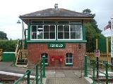
The remnant of the Wealden Line
Wealden Line
Taking its name from its route through the chalk hills of the North and South Downs of the Weald, England, the Wealden Line is a partly abandoned double track railway line in East Sussex and Kent that connected Lewes with Tunbridge Wells, a distance of ....
, the Lavender Line Steam Railway, is based here in the old Isfield Station
Isfield railway station
Isfield is a preserved railway station on the closed section of the Wealden Line which served the East Sussex village of Isfield near Uckfield. Originally opened in 1858, the station closed in 1969 and was sold into private hands in 1983 to subsequently become the current centrepiece of the...
. There is a campaign to reopen the line between Lewes
Lewes railway station
Lewes railway station serves the town of Lewes in East Sussex, England. It has five platforms and is on the East Coastway Line. Train services are provided by Southern.The station has a café and a newsagent, and there is a taxi office on the main forecourt...
and Uckfield
Uckfield railway station
Uckfield railway station serves Uckfield in East Sussex, England. Train services from the station are provided by Southern, and the station is the terminus for the Uckfield branch of the Oxted Line.- History :...
.
Religion
The parish church is dedicated to St Margaret of AntiochMargaret the Virgin
Margaret the Virgin, also known as Margaret of Antioch , virgin and martyr, is celebrated as a saint by the Roman Catholic and Anglican Churches on July 20; and on July 17 in the Orthodox Church. Her historical existence has been questioned; she was declared apocryphal by Pope Gelasius I in 494,...
. Within the church are tombs to the Shurley/Shirley family.
Leisure, culture and sport
The Laughing Fish is a small public housePublic house
A public house, informally known as a pub, is a drinking establishment fundamental to the culture of Britain, Ireland, Australia and New Zealand. There are approximately 53,500 public houses in the United Kingdom. This number has been declining every year, so that nearly half of the smaller...
with a garden.
The local cricket team, WG Gracefully plays in the East Sussex Cricket League.