

Iratais Point
Encyclopedia
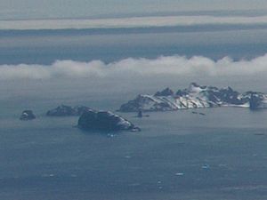
Desolation Island (South Shetland Islands)
Desolation Island is one of the minor islands in the South Shetlands archipelago, Antarctica situated at the entrance to Hero Bay, Livingston Island. The island is V-shaped with its northern coast indented by Kozma Cove. Surface area ....
situated in the entrance to Hero Bay, Livingston Island, Antarctica. Separated from Miladinovi Islets
Miladinovi Islets
Miladinovi Islets is a group of two small rocky islands, , and respectively, situated south of Iratais Point on Desolation Island off the north coast of Livingston Island, Antarctica. The islands are separated from Desolation Island by Neck or Nothing Passage...
to the south by Neck or Nothing Passage
Neck or Nothing Passage
Neck or Nothing Passage is a narrow passage leading from Blythe Bay between Iratais Point in the south end of Desolation Island and Miladinovi Islets, in the South Shetland Islands. The name was applied prior to 1830, probably by whalers who frequented Blythe Bay and who at times ran their...
.
The feature is named after Kavhan (hereditary viceroy
Viceroy
A viceroy is a royal official who runs a country, colony, or province in the name of and as representative of the monarch. The term derives from the Latin prefix vice-, meaning "in the place of" and the French word roi, meaning king. A viceroy's province or larger territory is called a viceroyalty...
function) Iratais, governor of the southern Bulgaria
Bulgaria
Bulgaria , officially the Republic of Bulgaria , is a parliamentary democracy within a unitary constitutional republic in Southeast Europe. The country borders Romania to the north, Serbia and Macedonia to the west, Greece and Turkey to the south, as well as the Black Sea to the east...
n Black Sea
Black Sea
The Black Sea is bounded by Europe, Anatolia and the Caucasus and is ultimately connected to the Atlantic Ocean via the Mediterranean and the Aegean seas and various straits. The Bosphorus strait connects it to the Sea of Marmara, and the strait of the Dardanelles connects that sea to the Aegean...
region under Khan Krum the Horrible
Krum of Bulgaria
Krum the Horrible was Khan of Bulgaria, from after 796, but before 803, to 814 AD. During his reign the Bulgarian territory doubled in size, spreading from the middle Danube to the Dnieper and from Odrin to the Tatra Mountains. His able and energetic rule brought law and order to Bulgaria and...
(9th century AD).
Location
The point is located at 62°28′10"S 60°20′16"W which is 3.33 km south-southeast of Cape DangerCape Danger
Cape Danger is the rocky point forming the northwest extremity of the ice-free Desolation Island situated in the entrance to Hero Bay, Livingston Island in the South Shetland Islands, Antarctica...
, 10.55 km west-southwest of Williams Point
Williams Point
Williams Point is the point forming both the north extremity of Varna Peninsula and the northeast tip of Livingston Island in the South Shetland Islands, Antarctica...
, 9.75 km north-northeast of Siddons Point
Siddons Point
Siddons Point is a point projecting into the middle of the head of Hero Bay on the north coast of Livingston Island in the South Shetland Islands, Antarctica...
and 23.27 km east by south of Cape Shirreff
Cape Shirreff
Cape Shirreff is a prominent cape at the north end of the rocky peninsula which separates Hero Bay and Barclay Bay on the north coast of Livingston Island, in the South Shetland Islands...
(British mapping in 1968, and Bulgarian in 2005 and 2009).
Maps
- L.L. Ivanov et al. Antarctica: Livingston Island and Greenwich Island, South Shetland Islands. Scale 1:100000 topographic map. Sofia: Antarctic Place-names Commission of Bulgaria, 2005.
- L.L. Ivanov. Antarctica: Livingston Island and Greenwich, Robert, Snow and Smith Islands. Scale 1:120000 topographic map. Troyan: Manfred Wörner Foundation, 2009. ISBN 978-954-92032-6-4