

Inland Waterway (Michigan)
Encyclopedia
River
A river is a natural watercourse, usually freshwater, flowing towards an ocean, a lake, a sea, or another river. In a few cases, a river simply flows into the ground or dries up completely before reaching another body of water. Small rivers may also be called by several other names, including...
s and lake
Lake
A lake is a body of relatively still fresh or salt water of considerable size, localized in a basin, that is surrounded by land. Lakes are inland and not part of the ocean and therefore are distinct from lagoons, and are larger and deeper than ponds. Lakes can be contrasted with rivers or streams,...
s in the U.S. state
U.S. state
A U.S. state is any one of the 50 federated states of the United States of America that share sovereignty with the federal government. Because of this shared sovereignty, an American is a citizen both of the federal entity and of his or her state of domicile. Four states use the official title of...
of Michigan
Michigan
Michigan is a U.S. state located in the Great Lakes Region of the United States of America. The name Michigan is the French form of the Ojibwa word mishigamaa, meaning "large water" or "large lake"....
. With only a short portage, it forms a navigable
Navigability
A body of water, such as a river, canal or lake, is navigable if it is deep, wide and slow enough for a vessel to pass. Preferably there are few obstructions such as rocks or trees to avoid. Bridges must have sufficient clearance. High water speed may make a channel unnavigable. Waters may be...
route for small craft connecting Lake Huron
Lake Huron
Lake Huron is one of the five Great Lakes of North America. Hydrologically, it comprises the larger portion of Lake Michigan-Huron. It is bounded on the east by the Canadian province of Ontario and on the west by the state of Michigan in the United States...
and Lake Michigan
Lake Michigan
Lake Michigan is one of the five Great Lakes of North America and the only one located entirely within the United States. It is the second largest of the Great Lakes by volume and the third largest by surface area, after Lake Superior and Lake Huron...
across the Northern Michigan
Northern Michigan
Northern Michigan, also known as Northern Lower Michigan , is a region of the U.S. state of Michigan...
region.
The route is in Emmet
Emmet County, Michigan
Emmet County is a county in the U.S. state of Michigan. As of the 2000 census, the population was 31,437. The county seat is Petoskey.The county was formed April 1, 1840, from Mackinac County. It was first named Tonedagana County and renamed Emmet County on March 8, 1843...
and Cheboygan
Cheboygan County, Michigan
-Commercial Airline:There are no commercial airline airports in Cheboygan County but the nearest ones are Alpena County Regional Airport, Chippewa County International Airport , and Cherry Capital Airport...
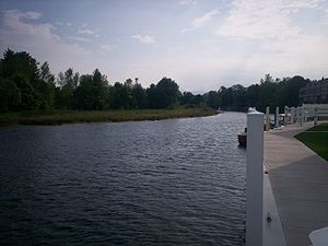
counties and consists of Round Lake, Iduna Creek, Crooked Lake, Crooked River
Crooked River (Michigan)
The Crooked River is a river in Emmet and Cheboygan counties in the U.S. state of Michigan. It is short stream, less than long, flowing northeast from Crooked Lake at near Alanson into Burt Lake at . It forms part of the Inland Waterway of Michigan....
, Burt Lake
Burt Lake
Burt Lake is a 17,120 acre lake in Cheboygan County in the U.S. state of Michigan. The western shore of the lake is on the boundary with Emmet County...
, Indian River
Indian River (Mullett Lake)
Indian River in the Lower Peninsula of Michigan is a short waterway in Cheboygan County that flows from Burt Lake at to Mullett Lake at...
, Mullett Lake
Mullett Lake
Mullett Lake is a lake in Cheboygan County in the U.S. state of Michigan. The lake is named after John Mullett, who, together with William A. Burt, made a federal survey of the area from 1840 to 1843. A neighboring lake was named after Burt. Historically, Mullett Lake has been recorded as Mullet...
, and the Cheboygan River
Cheboygan River
The Cheboygan River is a short but significant river in the Lake Huron drainage basin of the U.S. state of Michigan. in length, the Cheboygan River flows from the north end of Mullett Lake at to the Straits of Mackinac at . The river forms the boundary between Benton Township and Inverness...
.
The route passes through or near the communities of Conway, Oden, Ponshewaing, Alanson
Alanson, Michigan
Alanson is a village in Emmet County in the U.S. state of Michigan. As of the 2000 census, the village population was 785.Alanson is in Littlefield Township on U.S. Highway 31 at the junction with M-68. Petoskey is about southwest on US 31 and Mackinaw City and the Mackinac Bridge are about north...
, Indian River
Indian River, Michigan
Indian River is an unincorporated community in Cheboygan County in the U.S. state of Michigan. It is a census-designated place for statistical purposes and is not legally recognized as a municipality. The population was 2,008 at the 2000 census....
, Topinabee, and Cheboygan
Cheboygan, Michigan
Cheboygan is a city in the U.S. state of Michigan. As of the 2000 census, the city population was 5,295. It is the county seat of Cheboygan County....
.
Early history
The Inland Waterway was originally used by Native Americans to avoid the strong waves around Waugoshance PointWaugoshance Point
Waugoshance Point is a headland that juts into Lake Michigan from the northwest coast of the Lower Peninsula of the U.S. state of Michigan. It lies entirely within Wilderness State Park in Emmet County. The nearest major town is Mackinaw City...
on Lake Michigan
Lake Michigan
Lake Michigan is one of the five Great Lakes of North America and the only one located entirely within the United States. It is the second largest of the Great Lakes by volume and the third largest by surface area, after Lake Superior and Lake Huron...
. Consequently, fifty Indian encampments have been discovered along the shores of the Inland Water Route. One such encampment, located in Ponshewaing, has artifacts dating back over 3,000 years.
Discovery by settlers
The Grand Rapids and Indiana RailroadGrand Rapids and Indiana Railroad
The Grand Rapids and Indiana Railroad at its height provided passenger and freight railroad services between Cincinnati, Ohio and the Straits of Mackinac in Michigan, USA...
reached Petoskey in 1873. This opened up the surrounding area to tourism, settlers, and lumbermen. This eventually led to various people proposing different ideas for the water way. One such plan was the transportation of mail along the waterway. This involved the dredging of Crooked River
Crooked River
-Places:In Canada:*Crooked River **Crooked River Provincial ParkIn New Zealand:*Crooked River In the United States:* Crooked River * Crooked River * Crooked River * Crooked River...
. Freight was eventually transported along the route. With the advent of the railroad as a cheaper means with which to move goods, the Inland Waterway fell into decline. Yet the railroad brought new life to the waterway as tourists discovered its charm. Eventually it became one of the busiest inland water routes in the country with 32 steamers running the route at its peak. Tours typically lasted from two to three hours a day. From 1876 until 1920, nearly 100 commercial water craft were in business on the Inland Waterway. These included types of boats such as the steam tugboats, side-wheel steamers, stern paddlewheel steamers, propeller driven steamers, naphtha steamers, and gas-powered water craft.
The Inland Waterway today
Today the region surrounding the route is still a tourist destination. The historical society for the region was founded in 2004 and is known as The Inland Water Route Historical Society. It also is home to a museum in Alanson.External links
- Inland Waterway, Michigan Interactive Fishweb
- The Inland Waterway, Indian River Tourist Bureau
- Northern Michigan's Inland Waterway, Indian River Chamber of Commerce