
Indirasagar
Encyclopedia
The Indirasagar Dam is a multipurpose key project of Madhya Pradesh
on the Narmada River
at Narmadanagar in the Khandwa district
of Madhya Pradesh
in India
. The foundation stone of the project was laid by late Smt Indira Gandhi
, former Prime Minister of India
on 23 October 1984. The construction of main dam started in 1992. The down stream projects of ISP are Omkareshwar
, Maheshwar
and Sardar Sarovar Project.
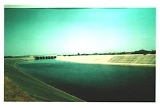
The Project envisages construction of a 92 m high and 653 m long concrete gravity dam
. It provides Irrigation
in 1,230 square kilometres of land with annual production of 2700 million units in the districts of Khandwa
and Khargone
in Madhya Pradesh and power generation of 1000 MW installed capacity (8x125). The reservoir of 12200000000 cubic metre was created. The dam, built as a joint venture between Madhya Pradesh irrigation and National Hydroelectric Power Corporation
is the source of the Indra Gandhi canal. It was commissioned on May 2005.
Indira Sagar Project is a multipurpose Project with an installed capacity of 1000 MW, with annual energy generation of 2698 Million Units in Stage – I, 1850 Million Units in Stage – II and 1515 Million Units in Stage – III and annual irrigation of 2.65 Lac. Ha on a Culturable Command Area (CCA) of 1.23 Lac. Ha. Total Catchment Area at the Dam site is 61642 Sq.Km. Indira Sagar Project is the mother project for the downstream projects on Narmada Basin with largest reservoir in India, having 12.22 Bm3 storage capacity. All the eight units commissioned by March ’05 ahead of schedule while generation from first unit was started from Jan.'04. The powerhouse is the second largest surface powerhouse in India.
Madhya Pradesh
Madhya Pradesh , often called the Heart of India, is a state in central India. Its capital is Bhopal and Indore is the largest city....
on the Narmada River
Narmada River
The Narmada , also called Rewa is a river in central India and the fifth largest river in the Indian subcontinent. It is the third largest river that completely flows within India after Ganges and Godavari...
at Narmadanagar in the Khandwa district
Khandwa District
Khandwa District , formerly known as East Nimar District, is a district of Madhya Pradesh state in central India. The city of Khandwa is the administrative headquarters of the district.-Geography:...
of Madhya Pradesh
Madhya Pradesh
Madhya Pradesh , often called the Heart of India, is a state in central India. Its capital is Bhopal and Indore is the largest city....
in India
India
India , officially the Republic of India , is a country in South Asia. It is the seventh-largest country by geographical area, the second-most populous country with over 1.2 billion people, and the most populous democracy in the world...
. The foundation stone of the project was laid by late Smt Indira Gandhi
Indira Gandhi
Indira Priyadarshini Gandhara was an Indian politician who served as the third Prime Minister of India for three consecutive terms and a fourth term . She was assassinated by Sikh extremists...
, former Prime Minister of India
Prime Minister of India
The Prime Minister of India , as addressed to in the Constitution of India — Prime Minister for the Union, is the chief of government, head of the Council of Ministers and the leader of the majority party in parliament...
on 23 October 1984. The construction of main dam started in 1992. The down stream projects of ISP are Omkareshwar
Omkareshwar
See Omkareshwar, East Nimar for town of the same nameOmkareshwar is a Hindu temple dedicated to God Shiva. It is one of the 12 revered Jyotirlinga shrines of Shiva....
, Maheshwar
Maheshwar
Maheshwar is a town in Khargone district of Madhya Pradesh state, in central India. It is located 13 km east of National Highway 3 and 91 km from Indore, the commercial capital of the state. The town lies on the north bank of the Narmada River.-Etymology:The name Maheshwar comes from...
and Sardar Sarovar Project.
The Project envisages construction of a 92 m high and 653 m long concrete gravity dam
Dam
A dam is a barrier that impounds water or underground streams. Dams generally serve the primary purpose of retaining water, while other structures such as floodgates or levees are used to manage or prevent water flow into specific land regions. Hydropower and pumped-storage hydroelectricity are...
. It provides Irrigation
Irrigation
Irrigation may be defined as the science of artificial application of water to the land or soil. It is used to assist in the growing of agricultural crops, maintenance of landscapes, and revegetation of disturbed soils in dry areas and during periods of inadequate rainfall...
in 1,230 square kilometres of land with annual production of 2700 million units in the districts of Khandwa
Khandwa District
Khandwa District , formerly known as East Nimar District, is a district of Madhya Pradesh state in central India. The city of Khandwa is the administrative headquarters of the district.-Geography:...
and Khargone
Khargone District
Khargone district , formerly known as West Nimar district , is a district of Madhya Pradesh state in central India. The district lies in Nimar region, and is part of Indore Division. Khargone town is the headquarters of this district.-History:...
in Madhya Pradesh and power generation of 1000 MW installed capacity (8x125). The reservoir of 12200000000 cubic metre was created. The dam, built as a joint venture between Madhya Pradesh irrigation and National Hydroelectric Power Corporation
National Hydroelectric Power Corporation
NHPC Limited , A Govt. of India Enterprise, was incorporated in the year 1975 with an authorised capital of Rs. 2000 million and with an objective to plan, promote and organize an integrated and efficient development of hydroelectric power in all aspects...
is the source of the Indra Gandhi canal. It was commissioned on May 2005.
Introduction
River Narmada, fifth largest river in India, with a river flow length of 1312 km originates from Amarkantak in Anuppur district of Madhya Pradesh. Narmada flows westward and after passing through Madhya Pradesh, Gujarat and Maharashtra, it drains into Arabian Sea near Gulf of Combay. Indira Sagar Project (ISP) situated on River Narmada, 10 Km from village Punasa in Khandwa district of Madhya Pradesh is commissioned on 31 March 2005.Indira Sagar Project is a multipurpose Project with an installed capacity of 1000 MW, with annual energy generation of 2698 Million Units in Stage – I, 1850 Million Units in Stage – II and 1515 Million Units in Stage – III and annual irrigation of 2.65 Lac. Ha on a Culturable Command Area (CCA) of 1.23 Lac. Ha. Total Catchment Area at the Dam site is 61642 Sq.Km. Indira Sagar Project is the mother project for the downstream projects on Narmada Basin with largest reservoir in India, having 12.22 Bm3 storage capacity. All the eight units commissioned by March ’05 ahead of schedule while generation from first unit was started from Jan.'04. The powerhouse is the second largest surface powerhouse in India.
Project Features
Brief Details of major components of project:- No. of Units, their rating and Capacity : 8 Units of 125 MW each – 1000 MW
- Concrete Gravity dam : 653 m Long & 92 m Height
- Diversion Tunnel : 688 m Long & 8 m Height
- Radial Gates : 20 Nos., 20 Long & 17 m height
- Power House : Surface with Francis Turbine Size – 200 m x 23m x 53 m
- Intake Structure : 208 m Long
- Water Conductor System : 8 Nos. Penstocks with 8 m dia.
- Head race Channel : 530 m Long & 75 m wide.
- Tail Race Channel : 850m Long & 30 m wide.
- Switchyard : 400 Kv, Open type.
Rehabilitation & Resettlement
- Villages affected: 249
- Family affected: 39179 PAF’s
- Land Submerged: 91348 Ha.