
Indiana State Road 59
Encyclopedia
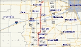
State Road 59 is a north–south road in Central Indiana that covers a distance of about 80 miles (128.7 km) through five counties.
(SR 58) and heads north towards Sandborn
. In Sandborn SR 59 has intersection
with State Road 67
(SR 67). Then SR 59 heads north towards Linton
where SR 59 is concurrenct
with State Road 54
(SR 54). Both route leave Linton on the northwest side of town. Then north of Linton SR 54 turns west toward Dugger
. SR 59 heads north passing through the east side of Jasonville
. SR 59 heads north from Jasonville towards Clay City
where SR 59 has a concurrency with State Road 246
. During the concurrency there is an intersection with State Road 157
in downtown Clay City. SR 59 heads north from Clay City toward Brazil
, on the way to Brazil SR 59 passes under Interstate 70
. In Brazil SR 59 has an intersection with U.S. Route 40 (US 40). SR 59 leaves Brazil heading north toward Waveland
, passing through an intersection with U.S. Route 36 and a concurrency with State Road 236
. In Waveland SR 59 enters from the south and has an intersection with State Road 47
.
Route description
State Road 59 begins at State Road 58Indiana State Road 58
State Road 58 is an east–west road in Central Indiana. State Road 58 runs from Merom in the west to Columbus in the east, a distance of approximately . Along its route it has concurrencies with one U.S. Route and six other Indiana state roads....
(SR 58) and heads north towards Sandborn
Sandborn, Indiana
Sandborn is a town in Vigo Township, Knox County, Indiana, United States. The population was 415 at the 2010 census. It is the home of the annual Black Creek Festival...
. In Sandborn SR 59 has intersection
Intersection (road)
An intersection is a road junction where two or more roads either meet or cross at grade . An intersection may be 3-way - a T junction or fork, 4-way - a crossroads, or 5-way or more...
with State Road 67
Indiana State Road 67
State Road 67 in the U.S. State of Indiana cuts a diagonal route from southwest to northeast across the state from the north side of Vincennes to Indianapolis to the Ohio state line, where it becomes State Route 29 east of Bryant.-Route description:...
(SR 67). Then SR 59 heads north towards Linton
Linton, Indiana
Linton is a city in Stockton Township, Greene County, Indiana, United States. The population was 5,774 at the 2000 census. A coal mining city, it is located southeast of Terre Haute. The current mayor is Patti Jones....
where SR 59 is concurrenct
Concurrency (road)
A concurrency, overlap, or coincidence in a road network is an instance of one physical road bearing two or more different highway, motorway, or other route numbers...
with State Road 54
Indiana State Road 54
State Road 54 is an east–west road in Central Indiana in Greene, Lawrence and Sullivan counties.-Route description:The western terminus of SR 54 is at U.S. Route 41. SR 54 heads east from US 41 toward Linton. Before Linton SR 54 meets SR 59 and they are concurrent...
(SR 54). Both route leave Linton on the northwest side of town. Then north of Linton SR 54 turns west toward Dugger
Dugger, Indiana
Dugger is a town in Cass Township, Sullivan County, Indiana, United States. The population was 955 at the 2000 census. It is part of the Terre Haute Metropolitan Statistical Area.-Geography:Dugger is located at ....
. SR 59 heads north passing through the east side of Jasonville
Jasonville, Indiana
Jasonville is a city in Greene County, Indiana, United States. The population was 2,222 at the 2010 census. It is part of the Bloomington, Indiana, Metropolitan Statistical Area.- History :...
. SR 59 heads north from Jasonville towards Clay City
Clay City, Indiana
Clay City is a town in Harrison Township, Clay County, Indiana, United States. The population was 861 at the 2010 census. It is part of the Terre Haute Metropolitan Statistical Area.-History:...
where SR 59 has a concurrency with State Road 246
Indiana State Road 246
State Road 246 is an east–west road in the southwest portion of the U.S. state of Indiana.-Route description:State Road 246 begins in the small town of Prairie Creek at State Road 63. Going east, it crosses U.S. Route 41 just north of Farmersburg...
. During the concurrency there is an intersection with State Road 157
Indiana State Road 157
State Road 157 in the U.S. State of Indiana is a north–south route in Clay, Greene and Owen counties that covers a distance of about .-Route description:...
in downtown Clay City. SR 59 heads north from Clay City toward Brazil
Brazil, Indiana
Brazil is a city in Clay County, Indiana, United States. The population was 7,912 at the 2010 census. The city is the county seat of Clay County. It is part of the Terre Haute Metropolitan Statistical Area...
, on the way to Brazil SR 59 passes under Interstate 70
Interstate 70 in Indiana
In the U.S. state of Indiana, Interstate 70 travels east–west across the state passing through Indianapolis. Interstate 70 crosses into Indiana near Terre Haute and crosses into Ohio in Richmond. It covers 156.60 miles in Indiana. It parallels U.S...
. In Brazil SR 59 has an intersection with U.S. Route 40 (US 40). SR 59 leaves Brazil heading north toward Waveland
Waveland, Indiana
Waveland is a town in Brown Township, Montgomery County, Indiana, United States. The population was 420 at the 2010 census.-History:Waveland was platted by John Milligan in 1835. The settlement began as a resting place at a good spring between Terre Haute and Lafayette, Indiana. After a trading...
, passing through an intersection with U.S. Route 36 and a concurrency with State Road 236
Indiana State Road 236
State Road 236 in the U.S. State of Indiana exists in two sections. The western section starts at U.S. Route 41 in Parke County, and runs eastward, paralleling its parent that lies to the south, U.S. Route 36...
. In Waveland SR 59 enters from the south and has an intersection with State Road 47
Indiana State Road 47
State Road 47 in the U.S. state of Indiana is a state highway in west-central and central Indiana. Although State Road 47 is signed as a north–south highway, it runs more east–west.-Route description:...
.