
Indiana State Road 54
Encyclopedia
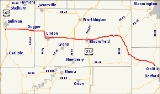
State Road 54 is an east–west road in Central Indiana in Greene
, Lawrence
and Sullivan
counties.
. SR 54 heads east from US 41 toward Linton
. Before Linton SR 54 meets SR 59 and they are concurrent
until Linton. In Linton SR 59 heads south and SR 54 heads east toward Switz City
. In Switz City SR 54 meets State Road 67
. After Switz City SR 54 meets U.S. Route 231. Then the two route head east toward Bloomfield
. In Bloomfield US 231 heads south and SR 54 heads east. After Bloomfield SR 54 heads east until State Road 43
, where SR 54 turns southeast toward Aavoca
. In Avoca SR 54 meets State Road 37
, at the eastern terminus of SR 54.
. Before the early 1980s SR 54 went as far west as SR 63.
Greene County, Indiana
Greene County is a county located in the U.S. state of Indiana, and determined by the U.S. Census Bureau to include the mean center of U.S. population in 1930. As of 2010, the population was 33,165. The county seat is Bloomfield....
, Lawrence
Lawrence County, Indiana
As of the census of 2000, there were 45,922 people, 18,535 households, and 13,141 families residing in the county. The population density was 102 people per square mile . There were 20,560 housing units at an average density of 46 per square mile...
and Sullivan
Sullivan County, Indiana
Sullivan County is a county located in the U.S. state of Indiana, and determined by the U.S. Census Bureau to include the mean center of U.S. population in 1940. As of 2010, the population was 21,475. The county seat is Sullivan. Sullivan County is included in the Terre Haute, Indiana,...
counties.
Route description
The western terminus of SR 54 is at U.S. Route 41U.S. Route 41 in Indiana
In the U.S. state of Indiana, U.S. Route 41 is a north–south highway that is parallel to the Illinois state line. It enters the state south of Evansville. North of Evansville, it becomes a 4-Lane divided highway passing around Vincennes and traveling North to Terre Haute. In Terre Haute, it...
. SR 54 heads east from US 41 toward Linton
Linton, Indiana
Linton is a city in Stockton Township, Greene County, Indiana, United States. The population was 5,774 at the 2000 census. A coal mining city, it is located southeast of Terre Haute. The current mayor is Patti Jones....
. Before Linton SR 54 meets SR 59 and they are concurrent
Concurrency (road)
A concurrency, overlap, or coincidence in a road network is an instance of one physical road bearing two or more different highway, motorway, or other route numbers...
until Linton. In Linton SR 59 heads south and SR 54 heads east toward Switz City
Switz City, Indiana
Switz City is a town in Fairplay and Grant townships, Greene County, Indiana, United States. The population was 293 at the 2010 census. It is part of the Bloomington, Indiana, Metropolitan Statistical Area.-Geography:...
. In Switz City SR 54 meets State Road 67
Indiana State Road 67
State Road 67 in the U.S. State of Indiana cuts a diagonal route from southwest to northeast across the state from the north side of Vincennes to Indianapolis to the Ohio state line, where it becomes State Route 29 east of Bryant.-Route description:...
. After Switz City SR 54 meets U.S. Route 231. Then the two route head east toward Bloomfield
Bloomfield, Indiana
Bloomfield is a town in Richland Township, Greene County, Indiana, United States. The population was 2,405 at the 2010 census. The city is the county seat of Greene County.Bloomfield is part of the Bloomington, Indiana Metropolitan Statistical Area....
. In Bloomfield US 231 heads south and SR 54 heads east. After Bloomfield SR 54 heads east until State Road 43
Indiana State Road 43
-Southern section:This winding, two-lane section of State Road 43 connects Indiana State Road 46 in Owen County near McCormick's Creek State Park with Indiana State Road 54 in eastern Greene County. It covers a distance of .-Northern section:...
, where SR 54 turns southeast toward Aavoca
Avoca, Indiana
Avoca is an unincorporated town in Marshall Township, Lawrence County, Indiana....
. In Avoca SR 54 meets State Road 37
Indiana State Road 37
State Road 37 in the U.S. State of Indiana is a major route in Indiana, running as a 4-lane divided highway for 110 miles of its course....
, at the eastern terminus of SR 54.
History
Between 1917 and 1926 the today's route of SR 54 was Indiana State Road 4 and Indiana State Road 30, also at that time the route number SR 54 was routed near the today's route of Indiana State Road 63Indiana State Road 63
State Road 63 in the U. S. state of Indiana is a north–south route in the western portion of the state. Until mid-2008, it covered a distance of just over , but now is a discontinuous route. For , from the city of Terre Haute until it rejoins U.S. Route 41 near Carbondale, it is a four-lane...
. Before the early 1980s SR 54 went as far west as SR 63.