
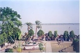
Ichamati River
Encyclopedia
Ichamati River(also spelt Ichhamati), is a trans-boundary river
which flows through India
and Bangladesh
and also forms the boundary between the two countries. The river is facing the problem of silt
ation leading to thin flow of water in the dry season and floods in the rainy season. Experts are handling the situation and remedial matters are being discussed between the governments of India and Bangladesh.
of the Padma
, and after flowing for 208 km joins the Kalindi River near Hasnabad
in North 24 Parganas and Debhata
in Satkhira District
. (2) Once the main river west of Dhaka and (3) Ichamati of Dinajpur. Rennel’s map of 1764-66, shows the last two rivers as one. According to a number of hydrologists, the three Ichamati rivers, in the past, were a single channel.
The second river marked above originates south of Jafarganj opposite to the mouth of the Hoorsagar near Nathpur factory and runs towards Joginighat in Munshiganj
. Joginighat is situated at the confluence of the Jamuna and the Ichamati. There are five pilgrimage ghats
along the river locally known as Panchatirtha ghats -Tirthaghat, Agla, Solepur, Barunighat and Joginighat.
in Bangladesh. It bifurcates near Majidia in Nadia District
in India, creating two rivers, Ichamati and Churni
. After traversing a length of 19.5 km in India, the Ichamati enters Bangladesh near Mubarakpur. It flows for 35.5 km in Bangladesh and again enters India at Duttaphulia in Nadia district. It forms the international border between India and Bangladesh for 21 km from Angrail to Kalanchi, and again from Goalpara to the Kalindi-Raimangal
outfall into the Bay of Bengal.
The Bhairab once flowed from the Ganges, across the present beds of the Jalangi
, and further eastwards towards Faridpur
. The Bhairab is no more a very active river. The Mathabhanga is a younger stream than Jalangi and it was not till very recently that the river completed its junction with the Hooghly by adopting the River Churni (now its lower reaches) for its main course. Earlier most of the water of the Mathabhanga ran off to the east down the Kumara, Chitra, Coboduk (Bhairab), and Ichamati, but all these escape routes have been shut off, except a small amount for the Ichamati. The point to note is that while earlier the rivers in the region flowed in a south-easterly direction, but later some force pulled the Jalangi and the Mathabhanga in a south-westerly direction. The inference is that it occurred because of a local subsidence, which was active for some period prior to 1750 and which has since become inactive.
 The river zone also faces the problem of industrial pollution and forcible occupation of land by people. Arresting environmental hazards resulting from lack of sanitation facilities, encroachment, groundwater contamination like arsenic pollution, destruction of aquatic flora, fauna are some of the burning problem of the areas that needs to be tackled through participatory mechanism.
Ichhamati river and its branches form a large oxbow lake complex near Bangaon
in North 24-Paraganas district. Besides agricultural and anthropogenic stresses, weed infestation particularly with water hyacinth
(Eichhornia crassipes
) is a major concern because it is covering the surface of lake waters.
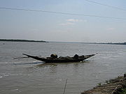
the immersion ceremony in the Ichamati offers a unique spectacle along the India-Bangladesh river border. The Ichhamati river, which acts as a natural border between the two countries, becomes the scene of tremendous revelry on this day, when boats crammed with people from both countries converge here to immerse their respective idols. Boats of all shapes and sizes can be seen on the river, as far as the eye can see — each one flying the flag of its respective country. It is the only day during the year when border patrolling is relaxed and people can cross over to the other side of the river. While earlier, after immersing their idols, people could even disembark from their boats on the other side, restrictions imposed by border officials in the last few years has put an end to this practice.
Trans-boundary river
A trans-boundary river is a river that crosses at least one political border, either a border within a nation or an international boundary. The country of Bangladesh has the greatest number of these rivers, almost all of which cross national boundaries....
which flows through India
India
India , officially the Republic of India , is a country in South Asia. It is the seventh-largest country by geographical area, the second-most populous country with over 1.2 billion people, and the most populous democracy in the world...
and Bangladesh
Bangladesh
Bangladesh , officially the People's Republic of Bangladesh is a sovereign state located in South Asia. It is bordered by India on all sides except for a small border with Burma to the far southeast and by the Bay of Bengal to the south...
and also forms the boundary between the two countries. The river is facing the problem of silt
Silt
Silt is granular material of a size somewhere between sand and clay whose mineral origin is quartz and feldspar. Silt may occur as a soil or as suspended sediment in a surface water body...
ation leading to thin flow of water in the dry season and floods in the rainy season. Experts are handling the situation and remedial matters are being discussed between the governments of India and Bangladesh.
Ichamati flow
Ichamati River is now in three parts – (1) The longer part flows from the Mathabhanga River, a distributaryDistributary
A distributary, or a distributary channel, is a stream that branches off and flows away from a main stream channel. They are a common feature of river deltas. The phenomenon is known as river bifurcation. The opposite of a distributary is a tributary...
of the Padma
Padma River
The Padma is a major trans-boundary river in Bangladesh. It is the main distributary of the Ganges , which originates in the Himalayas. The Padma enters Bangladesh from India near Chapai Nababganj...
, and after flowing for 208 km joins the Kalindi River near Hasnabad
Hasnabad
Hasnabad is an administrative division in Basirhat subdivision of North 24 Parganas district in the Indian state of West Bengal. Hasnabad police station serves this block...
in North 24 Parganas and Debhata
Debhata Upazila
Debhata is an Upazila of Satkhira District in the Division of Khulna, Bangladesh.-Geography:Debhata is located at . It has 17724 units of house hold and total area 176.33 km².-Demographics:...
in Satkhira District
Satkhira District
The district of Satkhira consists 3296 mosques, 1305 temples, 59 churches, 35 Buddhist temples, 8 tombs and 45 shrines.-Subdivisions:Satkhira subdivision was established in 1861 under Jessore district. It was included into Khulna district in 1882. The subdivision was upgraded into a district in...
. (2) Once the main river west of Dhaka and (3) Ichamati of Dinajpur. Rennel’s map of 1764-66, shows the last two rivers as one. According to a number of hydrologists, the three Ichamati rivers, in the past, were a single channel.
The second river marked above originates south of Jafarganj opposite to the mouth of the Hoorsagar near Nathpur factory and runs towards Joginighat in Munshiganj
Munshiganj District
Munshiganj also historically known as Bikrampur is a district in central Bangladesh. It is a part of the Dhaka Division and borders Dhaka District.-Geography:...
. Joginighat is situated at the confluence of the Jamuna and the Ichamati. There are five pilgrimage ghats
Ghats
As used in many parts of South Asia, the term ghat refers to a series of steps leading down to a water body, usually a holy river. In Bengali-speaking regions, this set of stairs can lead down to something as small as a pond or as large as a major river....
along the river locally known as Panchatirtha ghats -Tirthaghat, Agla, Solepur, Barunighat and Joginighat.
Lower Ichamati
The Mathabhanga River originates from the rightbank of the Padma, at Munshiganj in Kushtia DistrictKushtia District
Kushtia, Kushtia district or Kushtia Zila is a district in the Khulna administrative division of western Bangladesh. Kushtia has existed as a separate district since the partition of India. Prior to that, Kushtia was a part of Nadia District under Bengal Province of British India. Kushtia was home...
in Bangladesh. It bifurcates near Majidia in Nadia District
Nadia District
Nadia district is a district of the state of West Bengal, in the north east of India. It borders with Bangladesh to the east, North 24 Parganas and Hooghly districts to the south, Bardhaman district to the west, and Murshidabad district to the north....
in India, creating two rivers, Ichamati and Churni
River Churni
River Churni is a river in the Nadia district, West Bengal, India.-Course:The river flows through Shibnivas, Hanskhali, Birnagar, Aranghata, Ranaghat, and finally joins River Bagirathi near Chakdaha. Its length is almost 56 km...
. After traversing a length of 19.5 km in India, the Ichamati enters Bangladesh near Mubarakpur. It flows for 35.5 km in Bangladesh and again enters India at Duttaphulia in Nadia district. It forms the international border between India and Bangladesh for 21 km from Angrail to Kalanchi, and again from Goalpara to the Kalindi-Raimangal
Raimangal River
Raimangal River is a tidal estuarine river in and around the Sundarbans in North 24 Parganas district in the Indian state of West Bengal and Satkhira District in Bangladesh....
outfall into the Bay of Bengal.
The Bhairab once flowed from the Ganges, across the present beds of the Jalangi
Jalangi River
Jalangi River , is a branch of the Ganges in Murshidabad and Nadia districts in the Indian state of West Bengal. The Jalangi and the Mathabhanga flow into the Bhagirathi-Hooghly and strengthens its lower channel, the Hooghly....
, and further eastwards towards Faridpur
Faridpur District
Faridpur is a district in central Bangladesh. It is a part of the Dhaka Division. Faridpur District has a population of over 1.7 million people and is situated on the banks of the Padma river . It is bordered by Madaripur, Narail, Rajbari, Magura, Shariatpur, Gopalgonj, Dhaka and Manikganj...
. The Bhairab is no more a very active river. The Mathabhanga is a younger stream than Jalangi and it was not till very recently that the river completed its junction with the Hooghly by adopting the River Churni (now its lower reaches) for its main course. Earlier most of the water of the Mathabhanga ran off to the east down the Kumara, Chitra, Coboduk (Bhairab), and Ichamati, but all these escape routes have been shut off, except a small amount for the Ichamati. The point to note is that while earlier the rivers in the region flowed in a south-easterly direction, but later some force pulled the Jalangi and the Mathabhanga in a south-westerly direction. The inference is that it occurred because of a local subsidence, which was active for some period prior to 1750 and which has since become inactive.
River bed raised
While the bed of the Ichamati river is 14 feet higher than that of the Mathabhanga, that of the Churni is lower than Mathabhanga by six inches. During the lean period the level of water in the Mathabhanga is higher than that of the Padma. As a result, no water enters the Ichamati during the dry season. One of the causes of silting of the river was construction of guard wall for railway over bridge. The river beds in the area need to be excavated in order that there is flow of water during the lean season. Since this is required to be done both in India and Bangladesh, there is need for accord on this point. The matter has been discussed at the ministerial level, the area surveyed to have better idea of the problems of the people in the affected area, and decisive action is expected in the near future.Ichhamati river and its branches form a large oxbow lake complex near Bangaon
Bangaon
Bongaon is a city and a municipality in North 24 Parganas district in the state of West Bengal, India. Bongaon is headquarters of Bongaon subdivision.- Geography :...
in North 24-Paraganas district. Besides agricultural and anthropogenic stresses, weed infestation particularly with water hyacinth
Water hyacinth
The seven species of water hyacinth comprise the genus Eichhornia. Water hyacinth are a free-floating perennial aquatic plant native to tropical and sub-tropical South America. With broad, thick, glossy, ovate leaves, water hyacinth may rise above the surface of the water as much as 1 meter in...
(Eichhornia crassipes
Eichhornia crassipes
Eichhornia crassipes, commonly known as Common Water Hyacinth, is an aquatic plant native to the Amazon basin, and is often considered a highly problematic invasive species outside its native range.-Ecology:...
) is a major concern because it is covering the surface of lake waters.
Immersion of Durga images
At the end of Durga PujaDurga Puja
Durga puja ; দুর্গা পূজা,ଦୁର୍ଗା ପୂଜା,‘Worship of Durga’), also referred to as Durgotsava ; , is an annual Hindu festival in South Asia that celebrates worship of the Hindu goddess Durga. It refers to all the six days observed as Mahalaya, Shashthi, Maha Saptami, Maha Ashtami, Maha Navami and...
the immersion ceremony in the Ichamati offers a unique spectacle along the India-Bangladesh river border. The Ichhamati river, which acts as a natural border between the two countries, becomes the scene of tremendous revelry on this day, when boats crammed with people from both countries converge here to immerse their respective idols. Boats of all shapes and sizes can be seen on the river, as far as the eye can see — each one flying the flag of its respective country. It is the only day during the year when border patrolling is relaxed and people can cross over to the other side of the river. While earlier, after immersing their idols, people could even disembark from their boats on the other side, restrictions imposed by border officials in the last few years has put an end to this practice.