
Iaciara
Encyclopedia
| Iaciara | |
|---|---|
| State | Goiás Goiás Goiás is a state of Brazil, located in the central part of the country. The name Goiás comes from the name of an indigenous community... |
| Geographical Coordinates: | 14°06′38"S 46°37′36"W |
| Area: | 1,625.2 km² |
| Population: | 12,674(IBGE 2007) |
| Population density | 7.80 inhab/km² |
| Urban population | 9,033 |
| Rural population | 3,641 |
| Elevation: | 500m |
| Postcode (CEP): | 73920-000 |
| IBGE statistical microregion: | 018 Vão do Paranã |
| Became a city: | 1958 |
| Mayor: | Adão Luiz Ribeiro dos Santos |
| Distance to Goiânia Goiânia -Climate:The city has a tropical wet and dry climate with an average temperature of . There's a wet season, from October to April, and a dry one, from May to September. Annual rainfall is around 1,520 mm.... : |
548 km. |
| Website: | n/a |

Town
A town is a human settlement larger than a village but smaller than a city. The size a settlement must be in order to be called a "town" varies considerably in different parts of the world, so that, for example, many American "small towns" seem to British people to be no more than villages, while...
and municipality
Municipality
A municipality is essentially an urban administrative division having corporate status and usually powers of self-government. It can also be used to mean the governing body of a municipality. A municipality is a general-purpose administrative subdivision, as opposed to a special-purpose district...
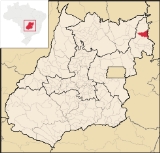
in northeastern Goiás
Goiás
Goiás is a state of Brazil, located in the central part of the country. The name Goiás comes from the name of an indigenous community...
state, Brazil
Brazil
Brazil , officially the Federative Republic of Brazil , is the largest country in South America. It is the world's fifth largest country, both by geographical area and by population with over 192 million people...
.
Geography
Iaciara is located in Vão do Paranã statistical micro-region, which borders the state of BahiaBahia
Bahia is one of the 26 states of Brazil, and is located in the northeastern part of the country on the Atlantic coast. It is the fourth most populous Brazilian state after São Paulo, Minas Gerais and Rio de Janeiro, and the fifth-largest in size...
. The distance to the state capital of Goiânia
Goiânia
-Climate:The city has a tropical wet and dry climate with an average temperature of . There's a wet season, from October to April, and a dry one, from May to September. Annual rainfall is around 1,520 mm....
is 548 kilometers. Highway connections are made by BR-153 / Anápolis
Anápolis
Anápolis is the third largest city in the State of Goiás in Brazil. It lies in the center of a rich agricultural region and has become a leader in food processing and pharmaceutical plants.-Location and population:...
/ GO-060 / Alexânia
Alexânia
Alexânia is a small town and municipality in central Goiás state, Brazil. Alexânia is known for its alleged extraterrestrial sightings in the late sixties and early seventies. The Areias River passes through the municipality.-Location:...
/ Formosa
Formosa, Goiás
Formosa is a city and municipality located in the state of Goiás, Brazil, approximately 80 kilometers east of Brasília. The population was 90,247 in a total area of 5,806.89 km² . Formosa is known for its waterfalls and natural beauty...
/ BR-020 / Alvorada do Norte
Alvorada do Norte
Alvorada do Norte is a small town and municipality in northeastern Goiás state, Brazil. It is an important commercial center on the Brasília-Salvador highway.-Location:...
/ GO-112 for 58 km.
The municipality has boundaries with Posse
Posse, Goiás
Posse is a small town and municipality in northeastern Goiás state, Brazil.-Geography:It is located northeast of Brasília, 24 km. from the state boundary with Bahia, on interstate highway BR-020...
, Alvorada do Norte
Alvorada do Norte
Alvorada do Norte is a small town and municipality in northeastern Goiás state, Brazil. It is an important commercial center on the Brasília-Salvador highway.-Location:...
, Guarani de Goiás
Guarani de Goiás
Guarani de Goiás is a small town and municipality in eastern Goiás state, Brazil. Guarani is a very poor municipality in the northeast of the state.-Geography:Guarani belongs to the Vão do Paranã statistical microregion...
, Nova Roma
Nova Roma
Nova Roma is an international Roman revivalist and reconstructionist organization created in 1998 by Joseph Bloch and William Bradford, later incorporated in Maine as a non-profit organization with an educational and religious mission...
and São Domingos
São Domingos
São Domingos can refer to many places in the world:*In Brazil:**São Domingos, Bahia**São Domingos, Goiás**São Domingos, Santa Catarina**São Domingos, Sergipe**São Domingos do Araguaia, Pará**São Domingos do Azeitão, Maranhão...
, and contains the following settlements: Claretiana, Extrema, Levantado and Água Quente.
The rivers that cross the municipality are: the Paranã
Paranã River
The Paranã River is located in Goiás state, Brazil. It divides two regions - the Northeast and north-central Goiás. It is formed by tributaries that descend the Serra Geral, the mountains that divide eastern Goiás and Bahia. One of the most important tributaries is the Crixás, which has its...
, Água Quente, São Bernardo and Prata.
Economics
The main economic activities are cattle raising and agriculture (rice, beans, corn and bananas). In 2007 there were 6 small transformation industries and 114 retail establishments. There was one bank.- Motor vehicles: 644 (automobiles and pickup trucks)
- Inhabitants per motor vehicle: 20
Agricultural data 2006
- Farms: 669
- Total area: 35,787 ha.
- Area of permanent crops: 125 ha.
- Area of perennial crops: 114 ha.
- Area of natural pasture: 23,873 ha.
- Area of woodland and forests: 10,923 ha.
- Persons dependent on farming: 2,500
- Cattle herd: 142,000
- Main crop: corn (1500 hectares in 2006)
Health and education
- Literacy rate: 79.5% (2000)
- Infant mortality rate: 20.46 in 1,000 live births
There were 17 schools and one hospital with 22 beds (2006).
Iaciara is ranked 206 out of 242 municipalities in the state of Goiás on the United Nations Human Development Index
Human Development Index
The Human Development Index is a composite statistic used to rank countries by level of "human development" and separate "very high human development", "high human development", "medium human development", and "low human development" countries...
with a score of 0.704. Nationally it is ranked 2,925 out of 5,507 municipalities.
History
The history of Iaciara began on 13 June 1881 when, at the Boa Vista ranch, the slave Miguel Cardoso da Conceiçao called for a prayer in the name of Santo Antonio. Since this prayer became traditional the owner of the ranch, Protassio de Souza, had structures of palm built to shelter the pilgrims. Nevertheless, Isidoro Teixeira, the first settler to build his house there, is considered to be the founder of the town. In 1885 the first house covered by tiles was built and the village was called Boa Vista. Later it was changed to Iracema. In 1887 the village was raised to the category of district with the name Iaciara, an Indian word of unknown origin. In 1958 Iaciara was dismembered from PossePosse, Goiás
Posse is a small town and municipality in northeastern Goiás state, Brazil.-Geography:It is located northeast of Brasília, 24 km. from the state boundary with Bahia, on interstate highway BR-020...
and became a municipality.
See also
- List of municipalities in Goiás
- Vão do Paranã MicroregionVão do Paranã MicroregionThe Vão do Paranã is a statistical micro-region created by IBGE in northeastern Goiás state, Brazil.*Population: 102,927 inhabitants *Cities: 12...
- Microregions in GoiásMicroregions in GoiásThe state of Goiás is divided into 18 statistical microregions by the Instituto Brasileiro de Geografia e Estatístic . These have no administrative function but are used only for statistics...