
.gif)
Hurricane Madeline (1998)
Encyclopedia
Hurricane Madeline was the final tropical cyclone
of the 1998 Pacific hurricane season
. Madeline originated from a tropical wave
that emerged off the coast of Africa
on September 25, 1998. The wave traversed the Atlantic Ocean
and crossed over Central America
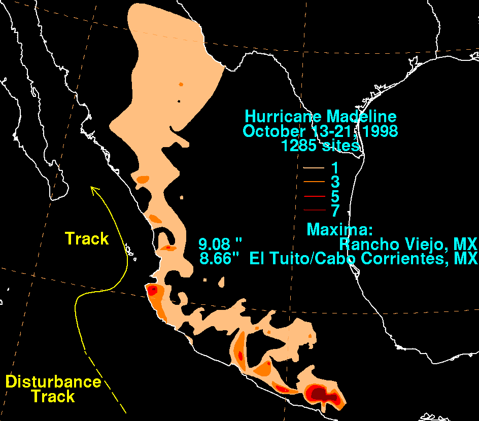
on October 5 or 6. Gradually, the system intensified and was classified as a tropical depression on October 16, a tropical storm later that day, and a hurricane on October 17. The storm reached peak winds of 85 mph (140 km/h) about 95 miles (150 km) southwest of San Blas, Nayarit
, and after 18 hours it subsequently began to weaken. Although Madeline never made landfall, numerous rainbands affected the Mexican
coast causing no known damage or fatalities. The remnant moisture moved north and contributed to flooding in central Texas
, which killed 31 people and caused $750 million (1998 USD) in damage.
emerged off the coast of Africa
, producing intermittent concentrated clusters of convective activity. The wave traversed the Atlantic Ocean
and the Caribbean Sea
before crossing Central America
on October 5 or October 6. After several days, onvection increased, and Dvorak classifications initiated. Satellite imagery indicated that the system dissipated on October 11, although an area of cloudiness persisted off the coast of Mexico
. After four days, the system regenerated and under diffluent flow aloft, deep convection became more concentrated; it is estimated that a tropical depression formed at 0000 UTC on October 16, about 230 mi (370.1 km) west-southwest of Manzanillo, Mexico. Initially, due to disorganization, determining the forward movement of depression was difficult, although a few hours later it was estimated that the system was tracking to the north-northwest. With favorable conditions aloft, the deep convection became more concentrated, and 12 hours after first developing, the depression intensified into Tropical Storm Madeline about 170 miles (273.6 km) southwest of Cabo Corrientes
.
During the afternoon, convective cloud tops warmed slightly although the storm continued to intensify. Soon after, thunderstorm activity became limited as Madeline remained generally stationary in movement. An approaching mid-level trough
turned Madeline to the northeast. Banding features gradually improved in organization, and late on October 17 the storm attained hurricane status. However, satellite imagery indicated that convective activity was confined to the western portion of the storm, and at the same time an eye
began to form. Early on October 18, data from a Reconnaissance aircraft flight into the storm found a minimum central pressure of 985 mbar (29.1 inHg), as the storm was drifting to the northeast at around 4 mph (6.4 km/h) near the western edge of a large-scale east–west ridge axis. The apparent eye became cloud-filled shortly thereafter, and a slight increase in temperature was discovered near the center. Despite this, upper-level outflow was favorable, leading to predictions of slight intensification.
Shortly thereafter, Madeline attained peak winds of 85 mph (140 km/h) about 95 miles (150 km) southwest of San Blas, Nayarit
. The hurricane maintained peak winds for about 18 hours while curving again to the northwest. With evidence of southern wind shear
, only a small area of deep thunderstorm activity existed on October 19, and the system began to appear ill-defined of satellite imagery. The hurricane quickly weakened into a tropical storm, and by later that day, the storm became void of convection due to strong wind shear. On October 19, the storm was downgraded to a tropical depression, leaving just a swirl of low clouds midway between the southern tip of Baja California and mainland Mexico. By 0600 UTC on October 20, the remnants of Madeline had completely dissipated.
 In anticipation of Madeline, the government of Mexico issued a tropical storm warning
for the Baja California Peninsula
southward from La Paz
, and a hurricane warning from San Patricio, Jalisco
to El Dorado, Sinaloa
, including the Islas Marías
. The storm was initially forecast to move ashore near Mazatlán
, prompting officials to close the city's port. President Ernesto Zedillo
advised potentially affected residents to stay indoors or seek refuge in shelters. Also, the threat of the hurricane canceled a fishing expedition in the Sea of Cortez due to rough surf. The expedition was to provide a new aquarium in downtown Denver, Colorado
with about 8,500 fish. Mexican authorities deployed 2,000 soldiers in remote areas of the Pacific coast state of Sinaloa to prepare for the hurricane. Several thousand residents and tourists at the resorts of Puerto Vallarta and Mazatlan were put on standby to evacuate their homes. Authorities along the coast in the state of Nayarit
went house to house, advising people about the oncoming storm. In addition, ships from Salina Cruz to Acapulco were advised to stay in port.
Although Madeline never crossed the coast, numerous rainbands affected the Mexican coast, dropping up to 9.8 in (248.9 mm). Despite this, no damage or fatalities were reported in Mexico. After the storm had dissipated, the remnant plume of moisture contributed to severe flooding in central Texas
. Rainfall in Texas reached 22 inches (560 mm) in some locations. Thirty-one people died due to the flooding, and damage totaled to $750 million (1998 USD).
Tropical cyclone
A tropical cyclone is a storm system characterized by a large low-pressure center and numerous thunderstorms that produce strong winds and heavy rain. Tropical cyclones strengthen when water evaporated from the ocean is released as the saturated air rises, resulting in condensation of water vapor...
of the 1998 Pacific hurricane season
1998 Pacific hurricane season
The 1998 Pacific hurricane season was a moderately active Pacific hurricane season with seven tropical cyclones directly affecting land. The season officially started on May 15 in the eastern Pacific, and on June 1 in the central Pacific, and ended on November 30; these dates conventionally delimit...
. Madeline originated from a tropical wave
Tropical wave
Tropical waves, easterly waves, or tropical easterly waves, also known as African easterly waves in the Atlantic region, are a type of atmospheric trough, an elongated area of relatively low air pressure, oriented north to south, which move from east to west across the tropics causing areas of...
that emerged off the coast of Africa
Africa
Africa is the world's second largest and second most populous continent, after Asia. At about 30.2 million km² including adjacent islands, it covers 6% of the Earth's total surface area and 20.4% of the total land area...
on September 25, 1998. The wave traversed the Atlantic Ocean
Atlantic Ocean
The Atlantic Ocean is the second-largest of the world's oceanic divisions. With a total area of about , it covers approximately 20% of the Earth's surface and about 26% of its water surface area...
and crossed over Central America
Central America
Central America is the central geographic region of the Americas. It is the southernmost, isthmian portion of the North American continent, which connects with South America on the southeast. When considered part of the unified continental model, it is considered a subcontinent...
on October 5 or 6. Gradually, the system intensified and was classified as a tropical depression on October 16, a tropical storm later that day, and a hurricane on October 17. The storm reached peak winds of 85 mph (140 km/h) about 95 miles (150 km) southwest of San Blas, Nayarit
San Blas, Nayarit
San Blas is both a municipality and municipal seat located on the Pacific coast of Mexico in the state of Nayarit.-City:San Blas is a port and a popular tourist destination, located about 100 miles north of Puerto Vallarta, and 40 miles west of the state capital Tepic. The town has a population of...
, and after 18 hours it subsequently began to weaken. Although Madeline never made landfall, numerous rainbands affected the Mexican
Mexico
The United Mexican States , commonly known as Mexico , is a federal constitutional republic in North America. It is bordered on the north by the United States; on the south and west by the Pacific Ocean; on the southeast by Guatemala, Belize, and the Caribbean Sea; and on the east by the Gulf of...
coast causing no known damage or fatalities. The remnant moisture moved north and contributed to flooding in central Texas
Texas
Texas is the second largest U.S. state by both area and population, and the largest state by area in the contiguous United States.The name, based on the Caddo word "Tejas" meaning "friends" or "allies", was applied by the Spanish to the Caddo themselves and to the region of their settlement in...
, which killed 31 people and caused $750 million (1998 USD) in damage.
Meteorological history
On September 25, 1998 a tropical waveTropical wave
Tropical waves, easterly waves, or tropical easterly waves, also known as African easterly waves in the Atlantic region, are a type of atmospheric trough, an elongated area of relatively low air pressure, oriented north to south, which move from east to west across the tropics causing areas of...
emerged off the coast of Africa
Africa
Africa is the world's second largest and second most populous continent, after Asia. At about 30.2 million km² including adjacent islands, it covers 6% of the Earth's total surface area and 20.4% of the total land area...
, producing intermittent concentrated clusters of convective activity. The wave traversed the Atlantic Ocean
Atlantic Ocean
The Atlantic Ocean is the second-largest of the world's oceanic divisions. With a total area of about , it covers approximately 20% of the Earth's surface and about 26% of its water surface area...
and the Caribbean Sea
Caribbean Sea
The Caribbean Sea is a sea of the Atlantic Ocean located in the tropics of the Western hemisphere. It is bounded by Mexico and Central America to the west and southwest, to the north by the Greater Antilles, and to the east by the Lesser Antilles....
before crossing Central America
Central America
Central America is the central geographic region of the Americas. It is the southernmost, isthmian portion of the North American continent, which connects with South America on the southeast. When considered part of the unified continental model, it is considered a subcontinent...
on October 5 or October 6. After several days, onvection increased, and Dvorak classifications initiated. Satellite imagery indicated that the system dissipated on October 11, although an area of cloudiness persisted off the coast of Mexico
Mexico
The United Mexican States , commonly known as Mexico , is a federal constitutional republic in North America. It is bordered on the north by the United States; on the south and west by the Pacific Ocean; on the southeast by Guatemala, Belize, and the Caribbean Sea; and on the east by the Gulf of...
. After four days, the system regenerated and under diffluent flow aloft, deep convection became more concentrated; it is estimated that a tropical depression formed at 0000 UTC on October 16, about 230 mi (370.1 km) west-southwest of Manzanillo, Mexico. Initially, due to disorganization, determining the forward movement of depression was difficult, although a few hours later it was estimated that the system was tracking to the north-northwest. With favorable conditions aloft, the deep convection became more concentrated, and 12 hours after first developing, the depression intensified into Tropical Storm Madeline about 170 miles (273.6 km) southwest of Cabo Corrientes
Cabo Corrientes
Cabo Corrientes is a cape on the Pacific coast of the Mexican state of Jalisco. It marks the southernmost point of the Bahía de Banderas, upon which the port and resort city of Puerto Vallarta stands. The municipality in which the cape lies is also called Cabo Corrientes.Cabo Corrientes is a...
.
During the afternoon, convective cloud tops warmed slightly although the storm continued to intensify. Soon after, thunderstorm activity became limited as Madeline remained generally stationary in movement. An approaching mid-level trough
Trough (meteorology)
A trough is an elongated region of relatively low atmospheric pressure, often associated with fronts.Unlike fronts, there is not a universal symbol for a trough on a weather chart. The weather charts in some countries or regions mark troughs by a line. In the United States, a trough may be marked...
turned Madeline to the northeast. Banding features gradually improved in organization, and late on October 17 the storm attained hurricane status. However, satellite imagery indicated that convective activity was confined to the western portion of the storm, and at the same time an eye
Eye (cyclone)
The eye is a region of mostly calm weather found at the center of strong tropical cyclones. The eye of a storm is a roughly circular area and typically 30–65 km in diameter. It is surrounded by the eyewall, a ring of towering thunderstorms where the second most severe weather of a cyclone...
began to form. Early on October 18, data from a Reconnaissance aircraft flight into the storm found a minimum central pressure of 985 mbar (29.1 inHg), as the storm was drifting to the northeast at around 4 mph (6.4 km/h) near the western edge of a large-scale east–west ridge axis. The apparent eye became cloud-filled shortly thereafter, and a slight increase in temperature was discovered near the center. Despite this, upper-level outflow was favorable, leading to predictions of slight intensification.
Shortly thereafter, Madeline attained peak winds of 85 mph (140 km/h) about 95 miles (150 km) southwest of San Blas, Nayarit
San Blas, Nayarit
San Blas is both a municipality and municipal seat located on the Pacific coast of Mexico in the state of Nayarit.-City:San Blas is a port and a popular tourist destination, located about 100 miles north of Puerto Vallarta, and 40 miles west of the state capital Tepic. The town has a population of...
. The hurricane maintained peak winds for about 18 hours while curving again to the northwest. With evidence of southern wind shear
Wind shear
Wind shear, sometimes referred to as windshear or wind gradient, is a difference in wind speed and direction over a relatively short distance in the atmosphere...
, only a small area of deep thunderstorm activity existed on October 19, and the system began to appear ill-defined of satellite imagery. The hurricane quickly weakened into a tropical storm, and by later that day, the storm became void of convection due to strong wind shear. On October 19, the storm was downgraded to a tropical depression, leaving just a swirl of low clouds midway between the southern tip of Baja California and mainland Mexico. By 0600 UTC on October 20, the remnants of Madeline had completely dissipated.
Preparations and impact
Tropical cyclone warnings and watches
Warnings and watches are two levels of alert issued by national weather forecasting bodies to coastal areas threatened by the imminent approach of a tropical cyclone of tropical storm or hurricane intensity. They are notices to the local population and civil authorities to make appropriate...
for the Baja California Peninsula
Baja California Peninsula
The Baja California peninsula , is a peninsula in northwestern Mexico. Its land mass separates the Pacific Ocean from the Gulf of California. The Peninsula extends from Mexicali, Baja California in the north to Cabo San Lucas, Baja California Sur in the south.The total area of the Baja California...
southward from La Paz
La Paz, Baja California Sur
La Paz is the capital city of the Mexican state of Baja California Sur and an important regional commercial center. The city had a 2010 census population of 215,178 persons, but its metropolitan population is somewhat larger because of surrounding towns like el Centenario, el Zacatal and San Pedro...
, and a hurricane warning from San Patricio, Jalisco
San Patricio, Jalisco
San Patricio - Melaque in the Mexican state of Jalisco is a busy community located 4+ kilometers northwest of Barra de Navidad on Bahia de Navidad. It was named for a unit of 175 mainly Irish immigrants, Saint Patrick's Battalion, that fought with the Mexican Army against the US during the...
to El Dorado, Sinaloa
El Dorado, Sinaloa
El Dorado is a community approximately one hour away from Culiacán in the Mexican state of Sinaloa. It is about a 20-minute drive from "Las Arenitas", a small fishing town.el dorado es caracterisado por sus umildes havitantes que en conjunto fe travajo hasen que el alimento y demas cosas...
, including the Islas Marías
Islas Marías
The Islas Marías are an archipelago of four islands that belong to Mexico. They are located in the Pacific Ocean, some off the coast of the state of Nayarit. They are part of the municipality of San Blas, Nayarit...
. The storm was initially forecast to move ashore near Mazatlán
Mazatlán
Mazatlán is a city in the Mexican state of Sinaloa; the surrounding municipio for which the city serves as the municipal seat is Mazatlán Municipality. It is located at on the Pacific coast, across from the southernmost tip of the Baja California peninsula.Mazatlán is a Nahuatl word meaning...
, prompting officials to close the city's port. President Ernesto Zedillo
Ernesto Zedillo
Ernesto Zedillo Ponce de León is a Mexican economist and politician. He served as President of Mexico from December 1, 1994 to November 30, 2000, as the last of the uninterrupted seventy year line of Mexican presidents from the Institutional Revolutionary Party...
advised potentially affected residents to stay indoors or seek refuge in shelters. Also, the threat of the hurricane canceled a fishing expedition in the Sea of Cortez due to rough surf. The expedition was to provide a new aquarium in downtown Denver, Colorado
Denver, Colorado
The City and County of Denver is the capital and the most populous city of the U.S. state of Colorado. Denver is a consolidated city-county, located in the South Platte River Valley on the western edge of the High Plains just east of the Front Range of the Rocky Mountains...
with about 8,500 fish. Mexican authorities deployed 2,000 soldiers in remote areas of the Pacific coast state of Sinaloa to prepare for the hurricane. Several thousand residents and tourists at the resorts of Puerto Vallarta and Mazatlan were put on standby to evacuate their homes. Authorities along the coast in the state of Nayarit
Nayarit
Nayarit officially Estado Libre y Soberano de Nayarit is one of the 31 states which, with the Federal District, comprise the 32 Federal Entities of Mexico. It is divided in 20 municipalities and its capital city is Tepic.It is located in Western Mexico...
went house to house, advising people about the oncoming storm. In addition, ships from Salina Cruz to Acapulco were advised to stay in port.
Although Madeline never crossed the coast, numerous rainbands affected the Mexican coast, dropping up to 9.8 in (248.9 mm). Despite this, no damage or fatalities were reported in Mexico. After the storm had dissipated, the remnant plume of moisture contributed to severe flooding in central Texas
Texas
Texas is the second largest U.S. state by both area and population, and the largest state by area in the contiguous United States.The name, based on the Caddo word "Tejas" meaning "friends" or "allies", was applied by the Spanish to the Caddo themselves and to the region of their settlement in...
. Rainfall in Texas reached 22 inches (560 mm) in some locations. Thirty-one people died due to the flooding, and damage totaled to $750 million (1998 USD).
See also
- Other tropical cyclones name Madeline
- List of Pacific hurricanes