
Hurricane Irene–Olivia
Encyclopedia
Hurricane Irene–Olivia was the first actively tracked tropical cyclone
which moved into the eastern Pacific Ocean from the Atlantic basin. It originated as a tropical depression on September 11, 1971, in the tropical Atlantic. The cyclone tracked nearly due westward at a low latitude, passing through the southern Windward Islands and later over northern South America. In the southwest Caribbean Sea, it intensified to a tropical storm and later a hurricane. Irene made landfall
on southeastern Nicaragua on September 19, and maintained its circulation as it crossed the low-lying terrain of the country. Restrengthening after reaching the Pacific, Irene was renamed Hurricane Olivia, which ultimately attained peak winds of 115 mph (185 km/h). Olivia weakened significantly before moving ashore on the Baja California Peninsula
on September 30; the next day it dissipated.
In the Atlantic, Irene produced moderate rainfall and winds along its path, although impact was greatest in Nicaragua where it moved ashore as a hurricane. A total of 96 homes were destroyed, and 1,200 people were left homeless. The rainfall resulted in widespread flooding, killing three people in Rivas. In neighboring Costa Rica, Hurricane Irene caused more than $1 million (USD
) in damage to the banana crop. Later, the remnants of Hurricane Olivia produced rainfall in the southwest United States. Flooding was reported near Yuma, Arizona
, which closed a major highway, and the moisture produced snowfall in higher elevations in the Rocky Mountains.
that exited the west African coast on September 7. It moved rapidly westward, developing into a tropical depression on September 11 about 800 miles (1300 km) east of the Windward Islands
. It was one of seven active tropical cyclone
s in the Atlantic basin
that day, one of the most active single days on record. It existed at a fairly low latitude and failed to intensify due to the unfavorable combination of Hurricane Ginger and a long trough
to its northwest. On September 13, the depression passed just south of Barbados and subsequently entered the Caribbean Sea. Interacting with the terrain of South America, the center became broad and ill-defined, although Curaçao
reported winds of near tropical storm force as it crossed the island on September 16. It later moved near or over northern Venezuela and Colombia. As it approached the western Caribbean, the depression was able to organize more, with less influence from landmass or the trough to its north. At 0000 UTC
on September 17, it is estimated the depression attained tropical storm status; that day, it was named Irene about 350 miles (560 km) east of San Andrés. Initially, the storm was expected to track west-northwestward toward the northwest Caribbean, similar to the track taken by the destructive Hurricane Edith two weeks prior.
Tropical Storm Irene gradually intensified as it continued across the southwestern Caribbean Sea. Late on September 18, the storm attained hurricane status a short distance off the coast of Central America, with 80 mph (130 km/h) winds, its peak intensity in the Atlantic Ocean. As it strengthened, it developed an eye
and spiral rainbands that extended across Panama into the Pacific Ocean. Hurricane Irene weakened slightly as it approached the coast, although its pressure dropped to 989 mbar
. On September 19, the hurricane made landfall
in the Nicaragua
department
of Región Autónoma del Atlántico Sur
; it was the first tropical cyclone of hurricane intensity since 1911 to strike Nicaragua south of Bluefields
. Irene quickly weakened, deteriorating to tropical depression status within 18 hours of moving ashore. The circulation remained organized over the low-lying terrain of southern Nicaragua, possibly due to it crossing Lake Nicaragua
. After reaching the Pacific Ocean on September 20, the depression restrengthened to attain tropical storm status; upon doing so, it was re-designated by a new name, Olivia. It was the first time an Atlantic hurricane was tracked as a tropical cyclone while crossing Central America into the Pacific Ocean; subsequent research indicated there were earlier storms that accomplished the feat, although they were not known at the time.
As an Eastern Pacific tropical cyclone
, Olivia maintained well-defined outflow
and inflow. It gradually intensified as it paralleled the southern Central America coastline. Late on September 21, a Hurricane Hunters
flight reported winds of 80 mph (130 km/h) and an eye 23 miles (37 km) in diameter; based on the readings, Olivia was upgraded to hurricane status. For several days, Olivia moved west to west-northwestward off the coast of Mexico, although its exact intensity fluctuations were unknown, due to lack of significant observations. On September 25, the eye became very pronounced on satellite imagery, and based on a report from the Hurricane Hunters, it is estimated Olivia reached peak winds of 115 mph (185 km/h), about 245 miles (395 km) southwest of Manzanillo, Colima
. The Hurricane Hunters also reported a pressure of 948 mbar, which was the lowest reported pressure during the 1971 Pacific hurricane season
.
The intensity of Hurricane Olivia fluctuated for two days as it turned westward away from land, due to a blocking ridge
over northwestern Mexico. Early on September 26 it weakened to winds of about 105 mph (165 km/h), before it quickly restrengthened to its previous peak intensity. Subsequently, dry air became entrained in the circulation, and Olivia began to weaken as it moved over cooler waters. The eye became disorganized and eventually dissipated. Late on September 28 it weakened to tropical storm status, after beginning a turn to the northwest and later to the north. About 24 hours later, Olivia weakened to tropical depression status as it approached the coastline of the Baja California Peninsula
. Most of the thunderstorm activity dissipated by the time the depression moved ashore on September 30; the next day, Olivia dissipated near the border of Baja California
and Baja California Sur
.
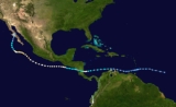
.png) As a tropical depression, the cyclone produced a wind gust of 43 mph (69 km/h) in Barbados. The system also dropped 3.35 inches (85.1 mm) of rainfall in Trinidad. Prior to its arrival, officials noted the potential for the depression to bring flash flooding to northern Venezuela, as well as heavy rainfall to the ABC islands. Later as a tropical storm, Irene brushed San Andrés island in the western Caribbean with gale force winds; no major damage was reported there.
As a tropical depression, the cyclone produced a wind gust of 43 mph (69 km/h) in Barbados. The system also dropped 3.35 inches (85.1 mm) of rainfall in Trinidad. Prior to its arrival, officials noted the potential for the depression to bring flash flooding to northern Venezuela, as well as heavy rainfall to the ABC islands. Later as a tropical storm, Irene brushed San Andrés island in the western Caribbean with gale force winds; no major damage was reported there.
Prior to the hurricane's landfall in Nicaragua, the country's army evacuated about 500 people from a settlement near Bluefields
, and along the coastline, boats were advised to remain at port. When it moved ashore, the hurricane produced sustained winds of 46 mph (74 km/h) in Bluefields
. The winds destroyed 27 houses in the region. Observations were not available in the sparsely populated region near where Irene moved ashore, although winds were believed to have reached hurricane force there. Reconnaissance
planes reported heavy structural and tree damage in southeastern Nicaragua. Satellite imagery suggested that heavy rainfall occurred from Panama through Honduras, and one location in Nicaragua reported more than 6.3 inches (160 mm) of precipitation. The rainfall caused flooding in many communities, killing three people in Rivas. At least five rivers reported flooding; along one of the rivers, 35 houses were inundated, and along another, the floodwaters swept away all of the crops and personal belongings of three villages. Across the country, the hurricane destroyed 96 homes, and 1,200 people were left homeless. In Costa Rica, Irene's passage resulted in more than $1 million (USD
) in damage to the banana crop.
Late in its duration, Hurricane Olivia brought increased moisture into the southwest United States. More than 2 inches (50 mm) of rainfall were reported across Arizona and New Mexico. Light precipitation was also reported in western Texas and southeastern California. The National Weather Service issued flash flood warnings throughout the region. Near Yuma, Arizona
, thunderstorms caused three major power outages and produced flooding that resulted in the closure of a portion of U.S. Route 95
. In Navajo
and Pinal
counties, the rainfall damaged roads, bridges, sewers, and homes, which amounted to about $250,000 in repair work for the state of Arizona. The storm's moisture also produced locally heavy snowfall in higher elevations in the Rocky Mountains
.
Irene–Olivia is unusual in that it survived passage from the Atlantic
to Pacific Ocean. Only seven other storms are known to have done so. Irene was the first of three Atlantic-to-Pacific crossover tropical cyclones in the 1970s, all three of which took eastern Pacific names starting with the letter O
.
Tropical cyclone
A tropical cyclone is a storm system characterized by a large low-pressure center and numerous thunderstorms that produce strong winds and heavy rain. Tropical cyclones strengthen when water evaporated from the ocean is released as the saturated air rises, resulting in condensation of water vapor...
which moved into the eastern Pacific Ocean from the Atlantic basin. It originated as a tropical depression on September 11, 1971, in the tropical Atlantic. The cyclone tracked nearly due westward at a low latitude, passing through the southern Windward Islands and later over northern South America. In the southwest Caribbean Sea, it intensified to a tropical storm and later a hurricane. Irene made landfall
Landfall (meteorology)
Landfall is the event of a tropical cyclone or a waterspout coming onto land after being over water. When a waterspout makes landfall it is reclassified as a tornado, which can then cause damage inland...
on southeastern Nicaragua on September 19, and maintained its circulation as it crossed the low-lying terrain of the country. Restrengthening after reaching the Pacific, Irene was renamed Hurricane Olivia, which ultimately attained peak winds of 115 mph (185 km/h). Olivia weakened significantly before moving ashore on the Baja California Peninsula
Baja California Peninsula
The Baja California peninsula , is a peninsula in northwestern Mexico. Its land mass separates the Pacific Ocean from the Gulf of California. The Peninsula extends from Mexicali, Baja California in the north to Cabo San Lucas, Baja California Sur in the south.The total area of the Baja California...
on September 30; the next day it dissipated.
In the Atlantic, Irene produced moderate rainfall and winds along its path, although impact was greatest in Nicaragua where it moved ashore as a hurricane. A total of 96 homes were destroyed, and 1,200 people were left homeless. The rainfall resulted in widespread flooding, killing three people in Rivas. In neighboring Costa Rica, Hurricane Irene caused more than $1 million (USD
United States dollar
The United States dollar , also referred to as the American dollar, is the official currency of the United States of America. It is divided into 100 smaller units called cents or pennies....
) in damage to the banana crop. Later, the remnants of Hurricane Olivia produced rainfall in the southwest United States. Flooding was reported near Yuma, Arizona
Yuma, Arizona
Yuma is a city in and the county seat of Yuma County, Arizona, United States. It is located in the southwestern corner of the state, and the population of the city was 77,515 at the 2000 census, with a 2008 Census Bureau estimated population of 90,041....
, which closed a major highway, and the moisture produced snowfall in higher elevations in the Rocky Mountains.
Meteorological history
The origins of the hurricane were from a tropical waveTropical wave
Tropical waves, easterly waves, or tropical easterly waves, also known as African easterly waves in the Atlantic region, are a type of atmospheric trough, an elongated area of relatively low air pressure, oriented north to south, which move from east to west across the tropics causing areas of...
that exited the west African coast on September 7. It moved rapidly westward, developing into a tropical depression on September 11 about 800 miles (1300 km) east of the Windward Islands
Windward Islands
The Windward Islands are the southern islands of the Lesser Antilles, within the West Indies.-Name and geography:The Windward Islands are called such because they were more windward to sailing ships arriving in the New World than the Leeward Islands, given that the prevailing trade winds in the...
. It was one of seven active tropical cyclone
Tropical cyclone
A tropical cyclone is a storm system characterized by a large low-pressure center and numerous thunderstorms that produce strong winds and heavy rain. Tropical cyclones strengthen when water evaporated from the ocean is released as the saturated air rises, resulting in condensation of water vapor...
s in the Atlantic basin
Atlantic Ocean
The Atlantic Ocean is the second-largest of the world's oceanic divisions. With a total area of about , it covers approximately 20% of the Earth's surface and about 26% of its water surface area...
that day, one of the most active single days on record. It existed at a fairly low latitude and failed to intensify due to the unfavorable combination of Hurricane Ginger and a long trough
Trough (meteorology)
A trough is an elongated region of relatively low atmospheric pressure, often associated with fronts.Unlike fronts, there is not a universal symbol for a trough on a weather chart. The weather charts in some countries or regions mark troughs by a line. In the United States, a trough may be marked...
to its northwest. On September 13, the depression passed just south of Barbados and subsequently entered the Caribbean Sea. Interacting with the terrain of South America, the center became broad and ill-defined, although Curaçao
Curaçao
Curaçao is an island in the southern Caribbean Sea, off the Venezuelan coast. The Country of Curaçao , which includes the main island plus the small, uninhabited island of Klein Curaçao , is a constituent country of the Kingdom of the Netherlands...
reported winds of near tropical storm force as it crossed the island on September 16. It later moved near or over northern Venezuela and Colombia. As it approached the western Caribbean, the depression was able to organize more, with less influence from landmass or the trough to its north. At 0000 UTC
Coordinated Universal Time
Coordinated Universal Time is the primary time standard by which the world regulates clocks and time. It is one of several closely related successors to Greenwich Mean Time. Computer servers, online services and other entities that rely on having a universally accepted time use UTC for that purpose...
on September 17, it is estimated the depression attained tropical storm status; that day, it was named Irene about 350 miles (560 km) east of San Andrés. Initially, the storm was expected to track west-northwestward toward the northwest Caribbean, similar to the track taken by the destructive Hurricane Edith two weeks prior.
Tropical Storm Irene gradually intensified as it continued across the southwestern Caribbean Sea. Late on September 18, the storm attained hurricane status a short distance off the coast of Central America, with 80 mph (130 km/h) winds, its peak intensity in the Atlantic Ocean. As it strengthened, it developed an eye
Eye (cyclone)
The eye is a region of mostly calm weather found at the center of strong tropical cyclones. The eye of a storm is a roughly circular area and typically 30–65 km in diameter. It is surrounded by the eyewall, a ring of towering thunderstorms where the second most severe weather of a cyclone...
and spiral rainbands that extended across Panama into the Pacific Ocean. Hurricane Irene weakened slightly as it approached the coast, although its pressure dropped to 989 mbar
Bar (unit)
The bar is a unit of pressure equal to 100 kilopascals, and roughly equal to the atmospheric pressure on Earth at sea level. Other units derived from the bar are the megabar , kilobar , decibar , centibar , and millibar...
. On September 19, the hurricane made landfall
Landfall (meteorology)
Landfall is the event of a tropical cyclone or a waterspout coming onto land after being over water. When a waterspout makes landfall it is reclassified as a tornado, which can then cause damage inland...
in the Nicaragua
Nicaragua
Nicaragua is the largest country in the Central American American isthmus, bordered by Honduras to the north and Costa Rica to the south. The country is situated between 11 and 14 degrees north of the Equator in the Northern Hemisphere, which places it entirely within the tropics. The Pacific Ocean...
department
Departments of Nicaragua
Nicaragua is a unitary republic, and for administrative purposes, it is divided into 15 departments and two self-governing regions based on the Spanish model:-Zelaya Department:...
of Región Autónoma del Atlántico Sur
Región Autónoma del Atlántico Sur
Región Autónoma del Atlántico Sur , sometimes shortened to RAAS, is one of two autonomous regions in Nicaragua. It covers an area of 27,407 km² and has a population of 382,100...
; it was the first tropical cyclone of hurricane intensity since 1911 to strike Nicaragua south of Bluefields
Bluefields
Bluefields is the capital of the municipality of the same name, and of Región Autónoma del Atlántico Sur in Nicaragua. It was also capital of the former Zelaya Department, which was divided into North and South Atlantic Autonomous Regions...
. Irene quickly weakened, deteriorating to tropical depression status within 18 hours of moving ashore. The circulation remained organized over the low-lying terrain of southern Nicaragua, possibly due to it crossing Lake Nicaragua
Lake Nicaragua
Lake Nicaragua or Cocibolca or Granada or is a vast freshwater lake in Nicaragua of tectonic origin. With an area of , it is the largest lake in Central America, the 19th largest lake in the world and the 9th largest in the Americas. It is slightly smaller than Lake Titicaca. With an elevation...
. After reaching the Pacific Ocean on September 20, the depression restrengthened to attain tropical storm status; upon doing so, it was re-designated by a new name, Olivia. It was the first time an Atlantic hurricane was tracked as a tropical cyclone while crossing Central America into the Pacific Ocean; subsequent research indicated there were earlier storms that accomplished the feat, although they were not known at the time.
As an Eastern Pacific tropical cyclone
Pacific hurricane
A Pacific hurricane or tropical storm is a tropical cyclone that develops in the northeastern part of the Pacific Ocean. For organizational purposes, the northern Pacific Ocean is divided into three regions: the eastern, , central , and western...
, Olivia maintained well-defined outflow
Outflow (meteorology)
Outflow, in meteorology, is air that flows outwards from a storm system. It is associated with ridging, or anticyclonic flow. In the low levels of the troposphere, outflow radiates from thunderstorms in the form of a wedge of rain-cooled air, which is visible as a thin rope-like cloud on weather...
and inflow. It gradually intensified as it paralleled the southern Central America coastline. Late on September 21, a Hurricane Hunters
Hurricane Hunters
The Hurricane Hunters are aircraft that fly into tropical cyclones in the North Atlantic Ocean and Northeastern Pacific Ocean for the specific purpose of directly measuring weather data in and around those storms. In the United States, the Air Force, Navy, and NOAA units have all participated in...
flight reported winds of 80 mph (130 km/h) and an eye 23 miles (37 km) in diameter; based on the readings, Olivia was upgraded to hurricane status. For several days, Olivia moved west to west-northwestward off the coast of Mexico, although its exact intensity fluctuations were unknown, due to lack of significant observations. On September 25, the eye became very pronounced on satellite imagery, and based on a report from the Hurricane Hunters, it is estimated Olivia reached peak winds of 115 mph (185 km/h), about 245 miles (395 km) southwest of Manzanillo, Colima
Manzanillo, Colima
The name Manzanillo refers to the city as well as its surrounding municipality in the Mexican state of Colima. The city, located on the Pacific Ocean, contains Mexico's busiest port. Manzanillo was the third port created by the Spanish in the Pacific during the New Spain period...
. The Hurricane Hunters also reported a pressure of 948 mbar, which was the lowest reported pressure during the 1971 Pacific hurricane season
1971 Pacific hurricane season
The 1971 Pacific hurricane season began on May 15, 1971 in the east Pacific, and on June 1, 1971 in the central Pacific. It ended on November 30, 1971. These dates conventionally delimit the period of time when tropical cyclones form in the east Pacific Ocean....
.
The intensity of Hurricane Olivia fluctuated for two days as it turned westward away from land, due to a blocking ridge
Ridge (meteorology)
A ridge is an elongated region of relatively high atmospheric pressure, the opposite of a trough....
over northwestern Mexico. Early on September 26 it weakened to winds of about 105 mph (165 km/h), before it quickly restrengthened to its previous peak intensity. Subsequently, dry air became entrained in the circulation, and Olivia began to weaken as it moved over cooler waters. The eye became disorganized and eventually dissipated. Late on September 28 it weakened to tropical storm status, after beginning a turn to the northwest and later to the north. About 24 hours later, Olivia weakened to tropical depression status as it approached the coastline of the Baja California Peninsula
Baja California Peninsula
The Baja California peninsula , is a peninsula in northwestern Mexico. Its land mass separates the Pacific Ocean from the Gulf of California. The Peninsula extends from Mexicali, Baja California in the north to Cabo San Lucas, Baja California Sur in the south.The total area of the Baja California...
. Most of the thunderstorm activity dissipated by the time the depression moved ashore on September 30; the next day, Olivia dissipated near the border of Baja California
Baja California
Baja California officially Estado Libre y Soberano de Baja California is one of the 31 states which, with the Federal District, comprise the 32 Federal Entities of Mexico. It is both the northernmost and westernmost state of Mexico. Before becoming a state in 1953, the area was known as the North...
and Baja California Sur
Baja California Sur
Baja California Sur , is one of the 31 states which, with the Federal District, comprise the 32 Federal Entities of Mexico. Before becoming a state on October 8, 1974, the area was known as the South Territory of Baja California. It has an area of , or 3.57% of the land mass of Mexico and comprises...
.
Impact and records
Prior to the hurricane's landfall in Nicaragua, the country's army evacuated about 500 people from a settlement near Bluefields
Bluefields
Bluefields is the capital of the municipality of the same name, and of Región Autónoma del Atlántico Sur in Nicaragua. It was also capital of the former Zelaya Department, which was divided into North and South Atlantic Autonomous Regions...
, and along the coastline, boats were advised to remain at port. When it moved ashore, the hurricane produced sustained winds of 46 mph (74 km/h) in Bluefields
Bluefields
Bluefields is the capital of the municipality of the same name, and of Región Autónoma del Atlántico Sur in Nicaragua. It was also capital of the former Zelaya Department, which was divided into North and South Atlantic Autonomous Regions...
. The winds destroyed 27 houses in the region. Observations were not available in the sparsely populated region near where Irene moved ashore, although winds were believed to have reached hurricane force there. Reconnaissance
Reconnaissance
Reconnaissance is the military term for exploring beyond the area occupied by friendly forces to gain information about enemy forces or features of the environment....
planes reported heavy structural and tree damage in southeastern Nicaragua. Satellite imagery suggested that heavy rainfall occurred from Panama through Honduras, and one location in Nicaragua reported more than 6.3 inches (160 mm) of precipitation. The rainfall caused flooding in many communities, killing three people in Rivas. At least five rivers reported flooding; along one of the rivers, 35 houses were inundated, and along another, the floodwaters swept away all of the crops and personal belongings of three villages. Across the country, the hurricane destroyed 96 homes, and 1,200 people were left homeless. In Costa Rica, Irene's passage resulted in more than $1 million (USD
United States dollar
The United States dollar , also referred to as the American dollar, is the official currency of the United States of America. It is divided into 100 smaller units called cents or pennies....
) in damage to the banana crop.
Late in its duration, Hurricane Olivia brought increased moisture into the southwest United States. More than 2 inches (50 mm) of rainfall were reported across Arizona and New Mexico. Light precipitation was also reported in western Texas and southeastern California. The National Weather Service issued flash flood warnings throughout the region. Near Yuma, Arizona
Yuma, Arizona
Yuma is a city in and the county seat of Yuma County, Arizona, United States. It is located in the southwestern corner of the state, and the population of the city was 77,515 at the 2000 census, with a 2008 Census Bureau estimated population of 90,041....
, thunderstorms caused three major power outages and produced flooding that resulted in the closure of a portion of U.S. Route 95
U.S. Route 95
U.S. Route 95 is a north–south U.S. highway in the western United States. Unlike many other US highways, it has not seen deletion or replacement on most of its length by an encroaching Interstate highway corridor, due to its mostly rural course...
. In Navajo
Navajo County, Arizona
-2010:Whereas according to the 2010 U.S. Census Bureau:*49.3% White*0.9% Black*43.4% Native American*0.5% Asian*0.1% Native Hawaiian or Pacific Islander*2.5% Two or more races*3.3% Other races*10.8% Hispanic or Latino -2000:...
and Pinal
Pinal County, Arizona
-2010:Whereas according to the 2010 U.S. Census Bureau:*72.4% White*4.6% Black*5.6% Native American*1.7% Asian*0.4% Native Hawaiian or Pacific Islander*3.8% Two or more races*11.5% Other races*28.5% Hispanic or Latino -2000:...
counties, the rainfall damaged roads, bridges, sewers, and homes, which amounted to about $250,000 in repair work for the state of Arizona. The storm's moisture also produced locally heavy snowfall in higher elevations in the Rocky Mountains
Rocky Mountains
The Rocky Mountains are a major mountain range in western North America. The Rocky Mountains stretch more than from the northernmost part of British Columbia, in western Canada, to New Mexico, in the southwestern United States...
.
Irene–Olivia is unusual in that it survived passage from the Atlantic
Atlantic Ocean
The Atlantic Ocean is the second-largest of the world's oceanic divisions. With a total area of about , it covers approximately 20% of the Earth's surface and about 26% of its water surface area...
to Pacific Ocean. Only seven other storms are known to have done so. Irene was the first of three Atlantic-to-Pacific crossover tropical cyclones in the 1970s, all three of which took eastern Pacific names starting with the letter O
O
O is the fifteenth letter and a vowel in the basic modern Latin alphabet.The letter was derived from the Semitic `Ayin , which represented a consonant, probably , the sound represented by the Arabic letter ع called `Ayn. This Semitic letter in its original form seems to have been inspired by a...
.
See also
- Hurricane Joan–Miriam of 1988
- List of Atlantic–Pacific crossover hurricanes
- List of South America cyclones
- Other tropical cyclones named Irene
- Other tropical cyclones named Olivia