
History of neighbourhoods in Toronto
Encyclopedia
Throughout its history, Toronto
has been a city divided into many communities and neighbourhood
s. As the city has grown, new neighbourhoods have been created out of once rural farmland. Over time, the neighbourhoods within existing areas have also been altered and rearranged.
The variety and breadth of neighbourhoods within the city has led to the moniker
"the city of neighbourhoods".
. For about two decades from its inception in 1793, most residents settled in an area bounded by present-day Jarvis and Parliament streets, south of Queen Street East (then known as Lot Street), and north of Front Street
, which at the time was at the waterfront. By 1815, this area was known as Old Town
, as a new neighbourhood formed to its west. Extending from present-day Jarvis street to Peter Street (and Blue Jay Way), south of Queen Street West
and north of Front Street, this became known as New Town. Sparsely populated in 1815, New Town grew rapidly during the 1820s and 1830s, and a rivalry formed between the two neighbourhoods, especially for the location of the Parliament Buildings.
s of the four nations of the British Isles (St. George
, St. Andrew
, St. Patrick
, and St. David
) and St. Lawrence, the patron saint of Canada. Today, only St. Lawrence
remains a well-known neighbourhood name. The others have attached their names to a variety of still existing landmarks including three subway stations. As Toronto grew, more wards were created, still named after prominent saints. St. James Ward is preserved in the modern St. James Town neighbourhood, while the northern ward of St. Paul's has continued to the present as a federal and provincial electoral district.
have disappeared leaving only a few traces, but many others, such as Malvern and Wexford have become well known neighbourhoods in the Toronto suburbs. On the main routes leaving the city small inns and taverns were established, often around the toll booths that were placed on the early highways and these often developed into small towns. There were three main routes out of the city: Kingston Road
leading to the east, Yonge Street
going north, and Dundas Street heading west. Weston Road
was another early route that saw some communities develop. A second type of town that developed in the hinterland surrounding early Toronto were small towns to support the farms that covered most of the region. These tended to develop at the intersection of two concession roads and were usually based around a post office or a small church.
line running along the shore of Lake Ontario. The central Union Station
was the meeting point of a number of lines, and this contributed to the growth of industry throughout the area between Queen Street and the lakeshore. East and west of downtown the major stations were established at Parkdale
and Riverside South, they both became centres of activity. Hotels such as the Gladstone and New Broadview House
opened to serve travellers.
Parts of town that had once been home to small rural communities were transformed by the railroad into major industrial areas. To the northwest of the city the small towns of Carleton and Davenport were subsumed into The Junction
and it became the site of many large factories and warehouses. To the east the towns of Strangford and Mortlake became known as Scarborough Junction.
Further away from town the railroads also altered geography. New communities developed around railway yards and facilities to house the workers. The largest of these was East Toronto
, which developed east of the city around the Grand Trunk's main yards. In the eastern part of Scarborough, Irish railway workers built up the town of West Hill
. The existing small town of Leaside
grew rapidly after a maintenance yard was built nearby.
 By the end of the 19th century the centre of old Toronto had become an almost wholly industrial and commercial area. Some residents stayed behind in these districts, generally poorer citizens and newly arrived immigrants. These became some of Toronto's first ethnically based neighbourhoods. The working class Irish who laboured in many of the factories were concentrated in the eastern part of the city, and these neighbourhoods were named Cabbagetown and Corktown
after them. Jewish immigrants also began arriving in considerable numbers at the end of the 19th century, and they settled in a region that was known as The Ward, centred at the corner of Bay and Dundas. In the early 20th century, Chinatown
would develop into another important neighbourhood just to the east.
Middle and upper class residents left the core and moved into new areas further out creating a number of new neighbourhoods. A ring of former farmland around the city was thus turned into new residential areas. These included The Annex
, named for its annexation to the city of Toronto, and the former village of Yorkville
. This process accelerated considerably at the end of the century with the introduction of the streetcar
. The streetcar allowed residents living outside the central business district to travel to work with ease. New areas, again mostly middle and upper class, grew up along the street car lines creating new neighbourhoods like Riverdale
, The Beaches
, North Toronto
, and Parkdale
.
, Riverdale
, Parkdale
High Park
, Junction
, Danforth, Earlscourt, Wychwood
, Willowvale
, North Toronto
, Beach
, and Leaside
. All these neighbourhoods are still commonly used today, with the exception of Willowvale, which is now known as Christie Pits, the name of the park it surrounds having been changed the same way.
In 1925 the Post Office divided Toronto into ten postal zones (see map), in an effort to facilitated mail sorting in an era before Postal Code
s. There was no obligation to use the zone numbers, and were originally not widely adopted. After the Second World War the zone numbers did begin to be used extensively. The postal districts became one of the primary ways of dividing up the city. Residents frequently described themselves as living in Toronto 2 or Toronto 10. The system was retained until 1971, with gradual modification. New zones were added as the city expanded outwards and downtown zones were subdivided as the number of homes and businesses in the core increased. By 1966 the urban areas of the city were covered by 19 zones, while more distant areas had their won letter codes, such as R for Rexdale and W for Willowdale.
 The years after the Second World War saw a dramatic change to the neighbourhoods of Toronto. The automobile made even more far flung suburbs possible, and the baby boom
encouraged their rapid construction. The next thirty years saw an explosion of growth in the townships around the city, and the region that soon became known as Metro Toronto
. Scarborough
, North York, and Etobicoke were transformed from largely rural farmland into vast stretches of housing. The early suburban developers did not put much emphasis on creating neighbourhoods, though in time many of these areas developed strong communities. Some suburbs embraced the names of the small villages that had once been there. Many others were given monikers invented by real estate agents attempting to market the land.
During this same era the downtown neighbourhoods saw significant changes. The Financial District
was growing northwards and The Ward and many of the oldest parts of Chinatown were demolished to make way for new projects, such as Toronto City Hall
. The Yorkville neighbourhood was also transformed from one of homes to one of hotels and stores.
The government also demolished many other areas labelled as "slums", replacing them with modern housing projects that were hypothesized to lead to much better lives for the inhabitants. Thus large parts of Cabbagetown and Corktown were levelled to build Regent Park
and Moss Park while St. James Town was transformed into a series of massive highrises similar to Le Corbusier
's "Towers in the Park" plan. In the suburbs, municipal governments also created new high rise neighbourhoods such as Flemingdon Park
and Crescent Town. Such projects came to a halt by the end of the 1970s when it was realized that such housing projects often became poverty stricken and crime ridden, while many of the untouched parts of Cabbagetown were quickly becoming some of the most desirable in the city. Under mayor David Crombie, new attempts at social housing were launched, such as the St. Lawrence
neighbourhood. These have managed to obtain similar densities without the social problems of earlier projects.
Residents and real estate soon found that giving neighbourhoods distinct names and identities made them more attractive. The 1970s thus saw much of the city divided into neighbourhoods. Older neighbourhood names were restored, such as Riverdale, though not before an attempt by real estate agents to rechristen the area Cabbagetown II, after the rapidly gentrifying area across the river. Other areas that had never before had clear names were given them. Some like Leslieville were taken from historic villages that once existed in the area. Others were based upon neighbouring districts such as the Upper Beaches
. Not all such attempts at naming areas were successful. Attempts to dub areas as Chester Village or the South Annex never won acceptance.
 By the 1980s almost all the open areas within the limits of Metro Toronto had been developed, with most of the growth in brand new developments occurring in the belt around Toronto known as the 905. This same era saw the rapid deindustrialization
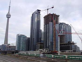
of Toronto, as almost all the factories and warehouses that had once dominated the waterfront disappeared. This created wide expanses for new developments and new neighbourhoods. A number of new communities have developed and are developing in these post-industrial zones, the largest of them being CityPlace
on the former railway lands. To the west and east other residential and cultural zones have appeared in areas such as Liberty Village
and the Distillery District. Other stretches of the waterfront, such as the West Donlands, and the Portlands
are still mostly empty, and awaiting redevelopment programmes.
With the disappearance of open spaces in the city of Toronto and the revitalization of the downtown there has been considerable condominium construction creating residential communities in areas that were once almost wholly commercial, such as the Financial District
and Yorkville. The suburbs have also seen considerable densification. North York Centre
has grown into a large cluster of condominiums and office buildings and a similar, though less dramatic process, is occurring at Scarborough City Centre
. Since the completion of the Sheppard subway line in 2002, there has been a boom in condominium construction along the route.
Toronto
Toronto is the provincial capital of Ontario and the largest city in Canada. It is located in Southern Ontario on the northwestern shore of Lake Ontario. A relatively modern city, Toronto's history dates back to the late-18th century, when its land was first purchased by the British monarchy from...
has been a city divided into many communities and neighbourhood
Neighbourhood
A neighbourhood or neighborhood is a geographically localised community within a larger city, town or suburb. Neighbourhoods are often social communities with considerable face-to-face interaction among members. "Researchers have not agreed on an exact definition...
s. As the city has grown, new neighbourhoods have been created out of once rural farmland. Over time, the neighbourhoods within existing areas have also been altered and rearranged.
The variety and breadth of neighbourhoods within the city has led to the moniker
Name of Toronto
The name of Toronto has a rich history distinct from that of the city itself. Originally, the term "Taronto" referred to a channel of water between Lake Simcoe and Lake Couchiching, but in time the name passed southward, and was eventually applied to a new fort at the mouth of the Humber River...
"the city of neighbourhoods".
New Town and Old Town
Before incorporation as a city in 1834, Toronto was known as YorkYork, Upper Canada
York was the name of Old Toronto between 1793 and 1834. It was the second capital of Upper Canada.- History :The town was established in 1793 by Governor John Graves Simcoe, with a new 'Fort York' on the site of the last French 'Fort Toronto'...
. For about two decades from its inception in 1793, most residents settled in an area bounded by present-day Jarvis and Parliament streets, south of Queen Street East (then known as Lot Street), and north of Front Street
Front Street (Toronto)
Front Street is an east-west road in downtown Toronto, Ontario, Canada. The street marks the rough outline of the shoreline of Lake Ontario as it existed during the original English settlement of York, then called Palace Street...
, which at the time was at the waterfront. By 1815, this area was known as Old Town
Old Town, Toronto
Old Town is a neighbourhood and retail district in downtown Toronto, Ontario, Canada. It takes its name from being on the site of the original Town of York, and its large number of 19th-century buildings...
, as a new neighbourhood formed to its west. Extending from present-day Jarvis street to Peter Street (and Blue Jay Way), south of Queen Street West
Queen Street West
Queen Street West describes both the western branch of Queen Street, a major east-west thoroughfare, and a series of neighbourhoods or commercial districts, situated west of Yonge Street in downtown Toronto, Ontario, Canada. Queen Street begins in the west at the intersection of King Street, The...
and north of Front Street, this became known as New Town. Sparsely populated in 1815, New Town grew rapidly during the 1820s and 1830s, and a rivalry formed between the two neighbourhoods, especially for the location of the Parliament Buildings.
The early ward system
The earliest Toronto neighbourhoods were the five municipal wards that the city was split into in 1834. The wards were named for the patron saintPatron saint
A patron saint is a saint who is regarded as the intercessor and advocate in heaven of a nation, place, craft, activity, class, clan, family, or person...
s of the four nations of the British Isles (St. George
Saint George
Saint George was, according to tradition, a Roman soldier from Syria Palaestina and a priest in the Guard of Diocletian, who is venerated as a Christian martyr. In hagiography Saint George is one of the most venerated saints in the Catholic , Anglican, Eastern Orthodox, and the Oriental Orthodox...
, St. Andrew
Saint Andrew
Saint Andrew , called in the Orthodox tradition Prōtoklētos, or the First-called, is a Christian Apostle and the brother of Saint Peter. The name "Andrew" , like other Greek names, appears to have been common among the Jews from the 3rd or 2nd century BC. No Hebrew or Aramaic name is recorded for him...
, St. Patrick
Saint Patrick
Saint Patrick was a Romano-Briton and Christian missionary, who is the most generally recognized patron saint of Ireland or the Apostle of Ireland, although Brigid of Kildare and Colmcille are also formally patron saints....
, and St. David
Saint David
Saint David was a Welsh Bishop during the 6th century; he was later regarded as a saint and as the patron saint of Wales. David was a native of Wales, and a relatively large amount of information is known about his life. However, his birth date is still uncertain, as suggestions range from 462 to...
) and St. Lawrence, the patron saint of Canada. Today, only St. Lawrence
St. Lawrence, Toronto
St. Lawrence is a neighbourhood located in downtown Toronto, Ontario, Canada. The area, a former industrial area, is bounded by Yonge, Front, and Parliament Streets, and the Canadian National railway embankment. The Esplanade off Yonge St., lined with restaurants, cafés and hotels runs through the...
remains a well-known neighbourhood name. The others have attached their names to a variety of still existing landmarks including three subway stations. As Toronto grew, more wards were created, still named after prominent saints. St. James Ward is preserved in the modern St. James Town neighbourhood, while the northern ward of St. Paul's has continued to the present as a federal and provincial electoral district.
Rural villages
Early 19th century Toronto was a town of a few thousand people. Most of the rest of the region that today makes up the city was rural farmland dotted with small villages. Some towns such as Norway, OntarioUpper Beaches
The Upper Beaches is a rather recently coined name for the neighbourhood directly north of the Beaches area in Toronto, Ontario, Canada. It stretches from Coxwell Avenue in the west to Victoria Park in the east. The southern border is Kingston Road, while the northern boundary is generally...
have disappeared leaving only a few traces, but many others, such as Malvern and Wexford have become well known neighbourhoods in the Toronto suburbs. On the main routes leaving the city small inns and taverns were established, often around the toll booths that were placed on the early highways and these often developed into small towns. There were three main routes out of the city: Kingston Road
Kingston Road (Toronto)
Kingston Road is the southernmost major road along the eastern portion of Toronto, specifically in the districts of East York and Scarborough. Until 1998, it formed a significant portion of Highway 2...
leading to the east, Yonge Street
Yonge Street
Yonge Street is a major arterial route connecting the shores of Lake Ontario in Toronto to Lake Simcoe, a gateway to the Upper Great Lakes. It was formerly listed in the Guinness Book of Records as the longest street in the world at , and the construction of Yonge Street is designated an "Event of...
going north, and Dundas Street heading west. Weston Road
Weston Road
Weston Road is a north-south street in west end Toronto, Ontario, Canada. The route is named for the former Village of Weston, which was located near Weston Road and Lawrence Avenue West....
was another early route that saw some communities develop. A second type of town that developed in the hinterland surrounding early Toronto were small towns to support the farms that covered most of the region. These tended to develop at the intersection of two concession roads and were usually based around a post office or a small church.
| Village | Location | Founded | Notes |
|---|---|---|---|
| Agincourt Agincourt, Toronto Agincourt is a very diverse neighbourhood in the Scarborough district of the city of Toronto, Ontario, Canada. It is centred along Sheppard Avenue between Kennedy and Markham Roads... |
Brimley and Sheppard | post office 1858 | Farming town with a post office and general store |
| Armadale Armadale, Ontario Armadale is the name of a community that overlaps into the Town of Markham and the former city of Scarborough in Toronto, Ontario, Canada. The historical community is situated in the south-east of Markham and north-east of Scarborough.-History:... |
Markham Road and Steeles | Settled c. 1805 post office 1869 | Originally known as Magdala |
| Bendale Bendale Bendale, also called Cedarbrae, is a neighbourhood in the eastern part of Toronto, Ontario, Canada, in Scarborough. The area is ethnically diverse, like much of Toronto, but has a greater proportion of South Asian population, especially Tamils.... |
Lawrence and McCowan | Settled 1799 post office 1878 | Originally known as Benlomond |
| Bedford Park Bedford Park, Toronto Bedford Park began as a farming hamlet north of Toronto. The hamlet was a popular stopover for farmers making their way to market in the city. The neighbourhood was likely named after the Bedford Park Hotel, which opened in 1873 at the southwest corner of Yonge Street and Fairlawn Avenue, just... |
Yonge and Lawrence | Bedford Park Hotel opened 1873 | |
| Birch Cliff Birch Cliff Birch Cliff is a neighbourhood in Toronto, Canada. It is located in the southwest part of the old city of Scarborough running along shore of Lake Ontario atop the eastern part of the Scarborough Bluffs. The area was first developed as the home of the Toronto Hunt Club in 1895 when the region was... |
Kingston and Birchmount | Post office 1908 | |
| Brockton Brockton Village Brockton Village is a neighbourhood in Toronto, Ontario, Canada. It comprises a section of the old Town of Brockton which was annexed by the City of Toronto in 1884. The town encompassed the area from Bloor Street on the north, Dufferin Street on the east, High Park on the west and ranged from... |
Dundas St W | Settled 1830s, incorporated 1876 | |
| Brown's Corners Brown's Corners, Toronto Brown's Corners is the name of a community in Scarborough in Toronto, Ontario, Canada at the corner of Finch Avenue East and Markham Road.David Brown operated a business and post office on the southwest corner. The Post Office was relocated to Malvern Village, but the business continued as a... |
Finch and Markham | Post office 1856 | Post office closed and moved to Malvern in 1865 |
| Chester | Danforth and Chester | 1850s | Also known as Doncaster, origin of the name of Chester Chester (TTC) Chester is a station on the Bloor–Danforth line of the subway system in Toronto, Canada. It is located at 370 Danforth Avenue at Chester Avenue, and was opened in 1966.... subway station |
| Coleman’s Corners | Danforth and Dawes | 1877 | Named after Charles Coleman, firs postmaster of the post office established in 1877. Also known as Little York |
| Davisville | Yonge and Davisville | Post office 1840s | |
| Don Vale Cabbagetown, Toronto Cabbagetown is a neighbourhood located on the east side of downtown Toronto, Ontario, Canada. It comprises "the largest continuous area of preserved Victorian housing in all of North America", according to the Cabbagetown Preservation Association.... |
Winchester and Don River | 1840s | Grew up around an inn by one of the main crossings of the Don |
| Downsview | Keele and Wilson | Settled 1842 | |
| Dublin | Sheppard and Dufferin | ||
| Eglinton | Yonge and Eglinton | 1800s | Also spelt Eglington |
| Elia | Keele and Finch | Settled 1790s, Post office 1878 | |
| Ellesmere | Kennedy and Ellesmere | Post office 1853 | |
| Emery Humbermede Humbermede, often called Emery, is a neighbourhood of Toronto, Ontario, Canada. Humbermede, like many of the "Humber" neighbourhoods in the city, gets its name from the Humber River... |
Weston and Finch | Settled 1790s, post office 1879 | Also known as Dayton |
| Fairbanks | Dufferin and Eglinton | Settled 1834, post office 1874 | |
| Flynntown | Leslie and Sheppard | ||
| Highland Creek Highland Creek, Toronto Highland Creek is a neighbourhood in south-east Scarborough in Toronto, Ontario, Canada that lies along the southern portion of the river of the same name... |
Kingston Road and Highland Creek | Settled 1802 | First community in Scarborough |
| Hillside | Finch and Meadowvale Road | School built 1847 | |
| Islington | Dundas and Islington | ||
| Kaiserville | Jane and Steeles | ||
| Lambton Mills Lambton Mills The Village of Lambton Mills was a settlement at the crossing of Dundas Street and the Humber River. The settlement was on both sides of the Humber River, in both the former Etobicoke Township and York Township, within today's City of Toronto, Ontario, Canada... |
Humber and Dundas | Settled 1806 | Originally named Cooper's Mills |
| L'Amoreaux L'Amoreaux L'Amoreaux is a neighbourhood in Toronto, Ontario, Canada, situated east of Victoria Park Avenue, south of McNicoll Avenue, west of Kennedy Road and north of Huntingwood Drive. L'Amoreaux is named after Josue L'Amoreaux , a French Huguenot loyalist who settled in the area... |
Finch and Birchmount | Settled 1816 school built 1847 | |
| Lansing | Yonge and Sheppard | Settled 1798 post office 1866 | |
| Leaside Leaside Leaside is a neighbourhood in Toronto, Ontario, Canada. The area takes its name from William Lea and the Lea family, who settled there in the early years of the nineteenth century. The area first developed as farmland along with Toronto through the nineteenth century. It was incorporated as a... |
Millwood and McRae | Settled 1819 | |
| Leslieville Leslieville Leslieville is a neighbourhood in Toronto, Ontario, Canada east of the Don River bounded by the Canadian National railway line and Gerrard Street to the north, Empire Avenue to the west, Eastern Avenue to south, and Coxwell Avenue to the east.-History:... |
Queen and Leslie | 1850s | Grew up around an inn on what was then Kingston Road |
| Malvern Malvern, Toronto Malvern is a neighbourhood in Toronto, Ontario, Canada, with a population of 44,315. It is located in the northeast corner of the city, in the district of Scarborough. Scarborough was merged with five other municipalities and a regional government to form the new City of Toronto in 1998... |
Sheppard and Markham Road | Post office 1865 | Originally known as Malcolm's Corners |
| Markland Wood Markland Wood Markland Wood is a residential neighbourhood located in Etobicoke, in the City of Toronto, Ontario, Canada. It is bounded by Etobicoke Creek to the west, Elmcrest Creek to the east and surrounded by the Markland Wood Country Club... |
Bloor Street Bloor Street Bloor Street is a major east–west residential and commercial thoroughfare in Toronto, in the Canadian province of Ontario. Bloor Street runs from the Prince Edward Viaduct westward into Mississauga, where it ends at Central Parkway. East of the viaduct, Danforth Avenue continues along the same... , Toronto's most western neighbourhood |
1960 | Originally known as Silverthorn Farm |
| Milneford Mills | Don River and Old Lawrence Road | 1830s | Demolished to make way for DVP |
| Milliken | Kennedy and Steeles | Post office 1859 | |
| Moffat's Corners | St. Clair and Victoria Park | 1863 | Post office established to serve rural area in 1863. Also known as Strangford |
| Mortlake | Midland and Kingston Rd | 1865 | Grew around the Halfway House Hotel |
| Newtonbrook | Yonge and Drewry | ||
| Norway Upper Beaches The Upper Beaches is a rather recently coined name for the neighbourhood directly north of the Beaches area in Toronto, Ontario, Canada. It stretches from Coxwell Avenue in the west to Victoria Park in the east. The southern border is Kingston Road, while the northern boundary is generally... |
Woodbine and Kingston Road | c. 1835 | Toll gate and then a small sawmill built on main route east of town |
| Port Union Port Union Port Union, also known as Centennial Scarborough is a neighbourhood located in Scarborough, part of Toronto, Ontario, Canada. The neighbourhood is bounded by Kingston Road to the north, Port Union Road to the east, the Lake Ontario shoreline to the south, and Highland Creek to the west.The... |
Lawrence and Port Union Road | Post office 1865 | |
| Rowntree Mills | Humber River south of Steeles | Settled 1840s | |
| Scarborough Village Scarborough Village Scarborough Village is a neighbourhood in Toronto, Ontario, Canada, in the south-central part of the district of Scarborough. Historically, it was one of the earliest settlements in the former Township of Scarborough and was the first region of the township to have its own post office... |
Markham and Eglinton | Post office 1832 | First post office in Scarborough, and origin of the name for the entire township |
| Smithfield Smithfield, Toronto Smithfield is part of the Rexdale neighbourhood in the northwestern area of Etobicoke, in the City of Toronto, Ontario, Canada. Some new residents to Toronto and new immigrants to Canada are attracted to this neighbourhood, mainly because there is a large amount of affordable public housing... |
Albion and Martingrove | ||
| Thistletown Thistletown Thistletown is a culturally diverse neighbourhood in Toronto, Ontario, Canada. Thistletown is also a part of the Rexdale community in the northern part of Etobicoke. It consists of the area surrounding the intersection of Albion Road and Islington Avenue in the former City of Etobicoke... |
Humber and Albion Rd | Also known as St. Andrew's and Coonats Corner | |
| Todmorden Mills Todmorden Mills Todmorden Mills was a small settlement located in the Don River valley in Toronto, Ontario. It started out as a lumber mill in the 1790s. Originally known as "Don Mills", it grew into a small industrial complex and village before becoming part of East York in the 20th century... |
Greenwood and Don River | c. 1795 | Established around a lumber mill built to provide wood for the construction of York |
| Wexford Wexford, Toronto Wexford is a neighbourhood in Toronto, Ontario, Canada. It is located in the eastern part of the city, on the western end of the district of Scarborough, spanning Lawrence Avenue East between Victoria Park Avenue and Birchmount Road. There are many Greeks in this neighbourhood.The Church of St... |
Lawrence and Pharmacy | School built 1847 | |
| Willowdale Willowdale, Toronto Willowdale is an established, affluent community in the city of Toronto, Ontario, Canada, located in the district of North York. It was originally called Lansing, which is now the name of a nearby neighbourhood.... |
Yonge and Sheppard | Settled 1797 | |
| Woburn Woburn, Toronto Woburn, also known as Cedarbrae, is a neighbourhood located in Toronto, Ontario, Canada, in the district of Scarborough.-Geography:Woburn is bordered by Highway 401 to the north, Scarborough Golf Club Road and Orton Park Road to the east, the CN Railway tracks to the south, and McCowan Road and... |
Markham and Old Danforth Road | Post office 1852 | Known as Elderslie until 1856 |
| York Mills York Mills York Mills is the name of an affluent neighbourhood around Yonge Street and York Mills Road located in the district of North York in the city of Toronto, Ontario, Canada.... |
Yonge and York Mills | First mill built 1804 |
Railroad towns
In the second half of the nineteenth century several rail lines were built across the Toronto area. This led to another group of towns being founded as rail lines and rail stations quickly became focal points for the creation of new towns and neighbourhoods. The most important was the Grand Trunk RailwayGrand Trunk Railway
The Grand Trunk Railway was a railway system which operated in the Canadian provinces of Quebec and Ontario, as well as the American states of Connecticut, Maine, Michigan, Massachusetts, New Hampshire, and Vermont. The railway was operated from headquarters in Montreal, Quebec; however, corporate...
line running along the shore of Lake Ontario. The central Union Station
Union Station (Toronto)
Union Station is the major inter-city rail station and a major commuter rail hub in Toronto, located on Front Street West and occupying the south side of the block bounded by Bay Street and York Street in the central business district. The station building is owned by the City of Toronto, while the...
was the meeting point of a number of lines, and this contributed to the growth of industry throughout the area between Queen Street and the lakeshore. East and west of downtown the major stations were established at Parkdale
Parkdale, Toronto
Parkdale is a neighbourhood and former village in Toronto, Ontario, Canada, west of downtown. The neighbourhood is bounded on the west by Roncesvalles Avenue, on the north by Queen Street. It is bounded on the east by Dufferin Street from Queen Street south, and on the south by Lake Ontario...
and Riverside South, they both became centres of activity. Hotels such as the Gladstone and New Broadview House
New Broadview House Hotel
The New Broadview House Hotel is a four story hotel at Broadview Avenue and Queen Street East in Toronto, Ontario.Built in 1893, the Romanesque style hotel was built for Archibald Dingham and located in the historic neighbourhood of Riverdale....
opened to serve travellers.
Parts of town that had once been home to small rural communities were transformed by the railroad into major industrial areas. To the northwest of the city the small towns of Carleton and Davenport were subsumed into The Junction
The Junction
The Junction is a neighbourhood in Toronto, Ontario, Canada, that is near the junction of four railway lines in the area known as the West Toronto Diamond. The neighbourhood was previously an independent city called West Toronto, that was also its own federal electoral district until amalgamating...
and it became the site of many large factories and warehouses. To the east the towns of Strangford and Mortlake became known as Scarborough Junction.
Further away from town the railroads also altered geography. New communities developed around railway yards and facilities to house the workers. The largest of these was East Toronto
East Toronto
East Toronto, Ontario was an incorporated community in what is today a part of the city of Toronto, Canada. It covered much of what is today the Upper Beaches neighbourhood, stretching up to Danforth Avenue in the north. The central street in the community was Main Street, running south from...
, which developed east of the city around the Grand Trunk's main yards. In the eastern part of Scarborough, Irish railway workers built up the town of West Hill
West Hill, Toronto
-Location and principal features:It is located in the eastern end of the city, in the former city of Scarborough. Scarborough was merged with five other municipalities and a regional government to form the new "City of Toronto" in 1998...
. The existing small town of Leaside
Leaside
Leaside is a neighbourhood in Toronto, Ontario, Canada. The area takes its name from William Lea and the Lea family, who settled there in the early years of the nineteenth century. The area first developed as farmland along with Toronto through the nineteenth century. It was incorporated as a...
grew rapidly after a maintenance yard was built nearby.
Urban slums and streetcar suburbs
Corktown, Toronto
Corktown is a residential neighbourhood in downtown Toronto, Ontario, Canada. It is just south of Regent Park and north of the Gardiner Expressway, between Berkeley Street to the west and the Don River to the east, Shuter Street to Lake Shore Boulevard East, this area also includes the Distillery...
after them. Jewish immigrants also began arriving in considerable numbers at the end of the 19th century, and they settled in a region that was known as The Ward, centred at the corner of Bay and Dundas. In the early 20th century, Chinatown
Chinatown, Toronto
Chinatown is an ethnic enclave in Downtown Toronto, Ontario, Canada, with a high concentration of ethnic Chinese residents and businesses extending along Dundas Street West and Spadina Avenue. First developed in the late 19th century, it is now one of the largest Chinatowns in North America and...
would develop into another important neighbourhood just to the east.
Middle and upper class residents left the core and moved into new areas further out creating a number of new neighbourhoods. A ring of former farmland around the city was thus turned into new residential areas. These included The Annex
The Annex
The Annex is a neighbourhood in downtown Toronto, Ontario, Canada. The traditional boundaries of the neighbourhood are north to Dupont Street, south to Bloor Street, west to Bathurst Street and east to Avenue Road...
, named for its annexation to the city of Toronto, and the former village of Yorkville
Yorkville, Toronto
Yorkville is a district in Toronto, Ontario, Canada, well known for its shopping. It is a former village, annexed by the City of Toronto. It is roughly bounded by Bloor Street to the south, Davenport Road to the north, Yonge Street to the east and Avenue Road to the west, and is considered part of...
. This process accelerated considerably at the end of the century with the introduction of the streetcar
Tram
A tram is a passenger rail vehicle which runs on tracks along public urban streets and also sometimes on separate rights of way. It may also run between cities and/or towns , and/or partially grade separated even in the cities...
. The streetcar allowed residents living outside the central business district to travel to work with ease. New areas, again mostly middle and upper class, grew up along the street car lines creating new neighbourhoods like Riverdale
Riverdale, Toronto
Riverdale is a large neighbourhood in Toronto, Ontario, Canada. It is bounded by the Don River Valley to the west, Danforth Avenue and Greektown to the north, Jones Avenue, the CN/GO tracks, and Leslieville to the east, and Lake Shore Boulevard to the south....
, The Beaches
The Beaches
The Beaches is a neighbourhood and popular tourist destination located in Toronto, Ontario, Canada. It is located on the east side of the "Old" City of Toronto. The original boundaries of the neighbourhood are from Fallingbrook Avenue on the east to Kingston Road on the north, to Woodbine Avenue...
, North Toronto
North Toronto
North Toronto was a town located in the northern part of the Old Toronto district in Toronto, Ontario, Canada. It occupies a geographically central location within the current boundaries of the city of Toronto. It is a relatively narrow strip, centred around Yonge Street; it extends from the CP...
, and Parkdale
Parkdale, Toronto
Parkdale is a neighbourhood and former village in Toronto, Ontario, Canada, west of downtown. The neighbourhood is bounded on the west by Roncesvalles Avenue, on the north by Queen Street. It is bounded on the east by Dufferin Street from Queen Street south, and on the south by Lake Ontario...
.
Postal districts
By the 1920s most the neighbourhoods of old Toronto had been established. In a non-comprehensive list a 1925 writer to the Star listed RosedaleRosedale, Toronto
Rosedale is an affluent neighbourhood in Toronto, Ontario, Canada, which was formerly the estate of William Botsford Jarvis, and so named by his wife, granddaughter of William Dummer Powell, for the wild roses that grew there in abundance....
, Riverdale
Riverdale, Toronto
Riverdale is a large neighbourhood in Toronto, Ontario, Canada. It is bounded by the Don River Valley to the west, Danforth Avenue and Greektown to the north, Jones Avenue, the CN/GO tracks, and Leslieville to the east, and Lake Shore Boulevard to the south....
, Parkdale
Parkdale, Toronto
Parkdale is a neighbourhood and former village in Toronto, Ontario, Canada, west of downtown. The neighbourhood is bounded on the west by Roncesvalles Avenue, on the north by Queen Street. It is bounded on the east by Dufferin Street from Queen Street south, and on the south by Lake Ontario...
High Park
High Park North
High Park North, or often, simply 'High Park', after the park, is a neighbourhood in Toronto, Ontario, Canada. It is bounded on the south by Bloor Street, on the west by Runnymede Road, on the north by Annette Street, Quebec Avenue and Humberside Avenue, and on the east by the CNR/CPR railway...
, Junction
The Junction
The Junction is a neighbourhood in Toronto, Ontario, Canada, that is near the junction of four railway lines in the area known as the West Toronto Diamond. The neighbourhood was previously an independent city called West Toronto, that was also its own federal electoral district until amalgamating...
, Danforth, Earlscourt, Wychwood
Wychwood
The Wychwood, or Wychwood Forest, is an area now covering a small part of rural Oxfordshire. In past centuries the forest covered a much larger area, since cleared in favour of agriculture, villages and towns. However, the forest's area has fluctuated...
, Willowvale
Christie Pits
Christie Pits Park, originally Willowvale Park, is a Toronto public recreational area located at 750 Bloor Street West at Christie Street, just west from the TTC Christie subway station...
, North Toronto
North Toronto
North Toronto was a town located in the northern part of the Old Toronto district in Toronto, Ontario, Canada. It occupies a geographically central location within the current boundaries of the city of Toronto. It is a relatively narrow strip, centred around Yonge Street; it extends from the CP...
, Beach
The Beaches
The Beaches is a neighbourhood and popular tourist destination located in Toronto, Ontario, Canada. It is located on the east side of the "Old" City of Toronto. The original boundaries of the neighbourhood are from Fallingbrook Avenue on the east to Kingston Road on the north, to Woodbine Avenue...
, and Leaside
Leaside
Leaside is a neighbourhood in Toronto, Ontario, Canada. The area takes its name from William Lea and the Lea family, who settled there in the early years of the nineteenth century. The area first developed as farmland along with Toronto through the nineteenth century. It was incorporated as a...
. All these neighbourhoods are still commonly used today, with the exception of Willowvale, which is now known as Christie Pits, the name of the park it surrounds having been changed the same way.
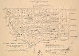
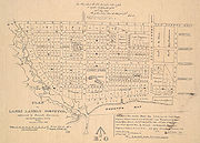
In 1925 the Post Office divided Toronto into ten postal zones (see map), in an effort to facilitated mail sorting in an era before Postal Code
Postal code
A postal code is a series of letters and/or digits appended to a postal address for the purpose of sorting mail. Once postal codes were introduced, other applications became possible.In February 2005, 117 of the 190 member countries of the Universal Postal Union had postal code systems...
s. There was no obligation to use the zone numbers, and were originally not widely adopted. After the Second World War the zone numbers did begin to be used extensively. The postal districts became one of the primary ways of dividing up the city. Residents frequently described themselves as living in Toronto 2 or Toronto 10. The system was retained until 1971, with gradual modification. New zones were added as the city expanded outwards and downtown zones were subdivided as the number of homes and businesses in the core increased. By 1966 the urban areas of the city were covered by 19 zones, while more distant areas had their won letter codes, such as R for Rexdale and W for Willowdale.
The suburbs and downtown clearances
Baby boom
A baby boom is any period marked by a greatly increased birth rate. This demographic phenomenon is usually ascribed within certain geographical bounds and when the number of annual births exceeds 2 per 100 women...
encouraged their rapid construction. The next thirty years saw an explosion of growth in the townships around the city, and the region that soon became known as Metro Toronto
Metropolitan Toronto
The Municipality of Metropolitan Toronto was a senior level of municipal government in the Toronto, Ontario, Canada area from 1954 to 1998. It was created out of York County and was a precursor to the later concept of a regional municipality, being formed of smaller municipalities but having more...
. Scarborough
Scarborough, Ontario
Scarborough is a dissolved municipality within the city of Toronto, Ontario, Canada. Geographically, it comprises the eastern part of Toronto. It is bordered on the south by Lake Ontario, on the west by Victoria Park Avenue, on the north by Steeles Avenue East, and on the east by the Rouge River...
, North York, and Etobicoke were transformed from largely rural farmland into vast stretches of housing. The early suburban developers did not put much emphasis on creating neighbourhoods, though in time many of these areas developed strong communities. Some suburbs embraced the names of the small villages that had once been there. Many others were given monikers invented by real estate agents attempting to market the land.
During this same era the downtown neighbourhoods saw significant changes. The Financial District
Financial District, Toronto
The Financial District is a business district in Toronto, Ontario, Canada, within the downtown core. It was originally planned as New Town in 1796 as an extension of the Town of York . It is the main financial district in Toronto, and is the financial heart of Canada...
was growing northwards and The Ward and many of the oldest parts of Chinatown were demolished to make way for new projects, such as Toronto City Hall
Toronto City Hall
The City Hall of Toronto, Ontario, Canada is the home of the city's municipal government and one of its most distinctive landmarks. Designed by Finnish architect Viljo Revell and landscape architect Richard Strong, and engineered by Hannskarl Bandel, the building opened in 1965...
. The Yorkville neighbourhood was also transformed from one of homes to one of hotels and stores.
The government also demolished many other areas labelled as "slums", replacing them with modern housing projects that were hypothesized to lead to much better lives for the inhabitants. Thus large parts of Cabbagetown and Corktown were levelled to build Regent Park
Regent Park
Regent Park is a neighbourhood located in Old Toronto, Ontario, Canada. Regent Park is Canada's oldest and largest social housing project; built in the late 1940s. Formerly the centre of the Cabbagetown neighbourhood, it is bounded by Gerrard Street East to the north, River Street to the east,...
and Moss Park while St. James Town was transformed into a series of massive highrises similar to Le Corbusier
Le Corbusier
Charles-Édouard Jeanneret, better known as Le Corbusier , was a Swiss-born French architect, designer, urbanist, writer and painter, famous for being one of the pioneers of what now is called modern architecture. He was born in Switzerland and became a French citizen in 1930...
's "Towers in the Park" plan. In the suburbs, municipal governments also created new high rise neighbourhoods such as Flemingdon Park
Flemingdon Park
Flemingdon Park is a multicultural community in Toronto, Ontario, Canada, located in the North York district of the city. It is part of federal and provincial electoral district Don Valley West, and Toronto electoral ward 26: Don Valley West...
and Crescent Town. Such projects came to a halt by the end of the 1970s when it was realized that such housing projects often became poverty stricken and crime ridden, while many of the untouched parts of Cabbagetown were quickly becoming some of the most desirable in the city. Under mayor David Crombie, new attempts at social housing were launched, such as the St. Lawrence
St. Lawrence, Toronto
St. Lawrence is a neighbourhood located in downtown Toronto, Ontario, Canada. The area, a former industrial area, is bounded by Yonge, Front, and Parliament Streets, and the Canadian National railway embankment. The Esplanade off Yonge St., lined with restaurants, cafés and hotels runs through the...
neighbourhood. These have managed to obtain similar densities without the social problems of earlier projects.
Neighbourhood revival
In the post-war years many traditional neighbourhood names faded as postal district numbers were in common use and many older neighbourhoods declined. The name Riverdale was one that faded as the once middle class area became much poorer. A 1964 Toronto Star series labelled the entire area north of Gerrard as The Danforth. A real estate agent working in the area for several years in the 1970s also reported never hearing the area referred to as Riverdale.Residents and real estate soon found that giving neighbourhoods distinct names and identities made them more attractive. The 1970s thus saw much of the city divided into neighbourhoods. Older neighbourhood names were restored, such as Riverdale, though not before an attempt by real estate agents to rechristen the area Cabbagetown II, after the rapidly gentrifying area across the river. Other areas that had never before had clear names were given them. Some like Leslieville were taken from historic villages that once existed in the area. Others were based upon neighbouring districts such as the Upper Beaches
Upper Beaches
The Upper Beaches is a rather recently coined name for the neighbourhood directly north of the Beaches area in Toronto, Ontario, Canada. It stretches from Coxwell Avenue in the west to Victoria Park in the east. The southern border is Kingston Road, while the northern boundary is generally...
. Not all such attempts at naming areas were successful. Attempts to dub areas as Chester Village or the South Annex never won acceptance.
Post-industrial Toronto
Deindustrialization
Deindustrialization is a process of social and economic change caused by the removal or reduction of industrial capacity or activity in a country or region, especially heavy industry or manufacturing industry. It is an opposite of industrialization.- Multiple interpretations :There are multiple...
of Toronto, as almost all the factories and warehouses that had once dominated the waterfront disappeared. This created wide expanses for new developments and new neighbourhoods. A number of new communities have developed and are developing in these post-industrial zones, the largest of them being CityPlace
CityPlace, Toronto
CityPlace is the name given to a large section of former railway land in downtown Toronto, Ontario, Canada that has been redeveloped for multi-use purpose. The term has been more recently used for a large up-scale multi-tower condo development in the Harbourfront district. When completed, this area...
on the former railway lands. To the west and east other residential and cultural zones have appeared in areas such as Liberty Village
Liberty Village
Liberty Village is a neighbourhood in Toronto, Ontario, Canada. It is bounded at the north by King Street West, the west by Dufferin Street, the south by the Gardiner Expressway, the east by Strachan Avenue, and the northeast by the CP railway tracks...
and the Distillery District. Other stretches of the waterfront, such as the West Donlands, and the Portlands
Port Lands
The Port Lands of Toronto, Ontario, Canada are an industrial and recreational neighbourhood located about 5 kilometres south-east of downtown, located on the former Don River delta and most of Ashbridge's Bay....
are still mostly empty, and awaiting redevelopment programmes.
With the disappearance of open spaces in the city of Toronto and the revitalization of the downtown there has been considerable condominium construction creating residential communities in areas that were once almost wholly commercial, such as the Financial District
Financial District, Toronto
The Financial District is a business district in Toronto, Ontario, Canada, within the downtown core. It was originally planned as New Town in 1796 as an extension of the Town of York . It is the main financial district in Toronto, and is the financial heart of Canada...
and Yorkville. The suburbs have also seen considerable densification. North York Centre
North York Centre
North York Centre is a town centre in North York, Toronto, Ontario, Canada. Prior to the Amalgamation of Toronto in 1998, it was considered the central business district of the former city of North York...
has grown into a large cluster of condominiums and office buildings and a similar, though less dramatic process, is occurring at Scarborough City Centre
Scarborough City Centre
Scarborough City Centre is the central business district in the Scarborough district of Toronto, Ontario, Canada. It is roughly bounded by Kennedy Road to the west, Markham Road to the east, Ellesmere Road to the south, and Sheppard Avenue to the North...
. Since the completion of the Sheppard subway line in 2002, there has been a boom in condominium construction along the route.
See also
- History of TorontoHistory of TorontoThe Toronto area was home to a number of First Nations groups who lived on the shore of Lake Ontario. At various times, the Neutral, Seneca, Mohawk and Cayuga nations were living in the vicinity of Toronto. The first permanent European presence was the French trading fort Fort Rouillé, which was...
- List of neighbourhoods in Toronto
- Architecture of TorontoArchitecture of TorontoThe architecture of Toronto is most marked by its being the financial and cultural capital of Canada, as well as the political capital of Ontario...