

History of Edmonton
Encyclopedia
Edmonton
Edmonton is the capital of the Canadian province of Alberta and is the province's second-largest city. Edmonton is located on the North Saskatchewan River and is the centre of the Edmonton Capital Region, which is surrounded by the central region of the province.The city and its census...
around 3,000 BC and perhaps as early as 10,000 BC, when an ice-free corridor opened up as the last ice age ended and timber, water, and wildlife became available in the region.
Early Days
Edmonton, like many places in North America had been inhabited for thousands of years by indigenous groups. First permanent settlement by EuropeEurope
Europe is, by convention, one of the world's seven continents. Comprising the westernmost peninsula of Eurasia, Europe is generally 'divided' from Asia to its east by the watershed divides of the Ural and Caucasus Mountains, the Ural River, the Caspian and Black Seas, and the waterways connecting...
ans is known to have started around 1795, when Fort Edmonton was officially founded around present day Fort Saskatchewan.
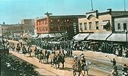
In the early 19th century, the fort was moved to near the current (Alberta) legislature site. The fort was big in the fur trade business. The first settlement outside of the fort was on "River lots", which actually now consist of neighbourhoods. In 1894, settlement began outside the fort and the Town of Edmonton was established. The town encompassed modern Boyle Street (the original downtown) and McCauley
McCauley
-Surname:*McCauley , an English-language surname with multiple etymological origins .-Places:* McCauley, Edmonton, an inner city neighbourhood located in Edmonton, Alberta, Canada....
neighbourhoods.
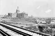
In the 1900-1910 period, the Hudson's Bay Company was granted a reserve on much of the Fort's land but in the decade it was eventually all sold off to Edmonton. Edmonton became a city in 1904 and shortly after, with a mere 5,000 people became Alberta's capital. With the new land west of Queens Avenue (modern 100 St) available to the city, the city grew tremendously, and Boyle Street was abandoned as the downtown for the new, current downtown. Many new communities like Glenora
Glenora, Edmonton
Glenora is a prime residential neighbourhood in the city of Edmonton, Alberta, Canada, overlooking the North Saskatchewan River valley.Glenora is bounded on the east by Groat Road, on the north by 107 Avenue, on the west by 142 Street, and on the south by the river valley and the McKinnon Ravine...
, Highlands
Highlands, Edmonton
Highlands is a residential neighbourhood in north east Edmonton, Alberta, Canada overlooking the North Saskatchewan River valley. The area was annexed by Edmonton in 1912, and "was named in a contest offering a 50-dollar prize."...
, and Westmount
Westmount, Edmonton
Westmount is an established central-west residential neighbourhood in Edmonton, Alberta, Canada. Westmount is wedge shaped with the point in the wedge overlooking the North Saskatchewan River valley, and is geographically close to the downtown core...
were built in this time as the economy started to gain momentum. And during the early 1910s, Edmonton grew very rapidly, causing rising speculation in real estate prices. In 1912, Edmonton amalgamated
Amalgamation (politics)
A merger or amalgamation in a political or administrative sense is the combination of two or more political or administrative entities such as municipalities , counties, districts, etc. into a single entity. This term is used when the process occurs within a sovereign entity...
with the city of Strathcona
Strathcona, Alberta
Strathcona was a city in Alberta, Canada, located on the south of the North Saskatchewan River opposite of the City of Edmonton. It amalgamated with Edmonton on February 1, 1912....
, south of the North Saskatchewan River; as a result, the city extended south of the river.
World War I
World War I , which was predominantly called the World War or the Great War from its occurrence until 1939, and the First World War or World War I thereafter, was a major war centred in Europe that began on 28 July 1914 and lasted until 11 November 1918...
, the real estate boom ended suddenly, causing the city's population to decline sharply—from over 72,500 in 1914 to under 54,000 only two years later., Recruitment to the Canadian military during the war also contributed to the drop in population. Afterwards, the city was slow to recover in population and economy during the 1920s and 1930s, until World War II
World War II
World War II, or the Second World War , was a global conflict lasting from 1939 to 1945, involving most of the world's nations—including all of the great powers—eventually forming two opposing military alliances: the Allies and the Axis...
.
The first licensed airfield in Canada, Blatchford Field (now Edmonton City Centre (Blatchford Field) Airport
Edmonton City Centre (Blatchford Field) Airport
Edmonton City Centre Airport, , is located within the city of Edmonton, Alberta, Canada. It is bordered by Yellowhead Trail to the north, Kingsway to the south, 121 Street to the west, and the Northern Alberta Institute of Technology to the east. It encompasses approximately of land just north...
), commenced operation in 1929. Pioneering aviators such as Wilfrid R. "Wop" May and Max Ward
Max Ward (bush pilot)
Maxwell "Max" William Ward, OC, AOE is a pioneering Canadian aviator and founder of Wardair airlines, at one time, the third-largest air carrier in Canada.-Early years:Max Ward was born 22 November 1921 in Edmonton, Alberta...
used Blatchford Field as a major base for the distribution of mail, food, and medicine to Northern Canada
Northern Canada
Northern Canada, colloquially the North, is the vast northernmost region of Canada variously defined by geography and politics. Politically, the term refers to the three territories of Canada: Yukon, Northwest Territories, and Nunavut...
; hence Edmonton's role as the "Gateway to the North" was strengthened. During World War II saw Edmonton's becoming a major base for the construction of the Alaska Highway
Alaska Highway
The Alaska Highway was constructed during World War II for the purpose of connecting the contiguous U.S. to Alaska through Canada. It begins at the junction with several Canadian highways in Dawson Creek, British Columbia and runs to Delta Junction, Alaska, via Whitehorse, Yukon...
and the Northwest Staging Route
Northwest Staging Route
The Northwest Staging Route was a series of airstrips, airport and radio ranging stations built in Alberta, British Columbia, the Yukon and Alaska during World War II. It was known in the Soviet Union as Alsib ....
.
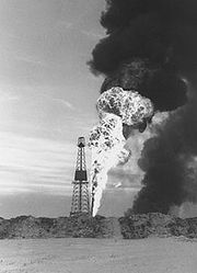
The oil boom years
Leduc, Alberta
- Demographics :The population of the City of Leduc according to its 2011 municipal census is 24,139, a 3.6% increase over its 2010 municipal census population of 23,293....
, south of Edmonton. As early as 1914, oil reserves
Oil reserves
The total estimated amount of oil in an oil reservoir, including both producible and non-producible oil, is called oil in place. However, because of reservoir characteristics and limitations in petroleum extraction technologies, only a fraction of this oil can be brought to the surface, and it is...
were known to exist in the southern parts of Alberta
Southern Alberta
Southern Alberta is a region located in the Canadian province of Alberta. As of the year 2004, the region's population was approximately 272,017. The primary cities are Lethbridge and Medicine Hat...
(see Turner Valley, Alberta
Turner Valley, Alberta
Turner Valley is a town in Alberta, Canada. It is located southwest of Calgary.Situated on Highway 22 , the town was once the centre of an oil and natural gas boom. For 30 years, the Turner Valley Oilfields was a major supplier of oil and gas and the largest producer in the British Empire, but is...
), but they produced very little oil compared to those around Edmonton. Additional oil reserves were discovered in the late 1940s and the 1950s near the town of Redwater
Redwater, Alberta
Redwater is a town in northern Alberta, Canada. It is located north of Edmonton on Highway 38, in Sturgeon County. Its population, as of 2006, was 2,192.Redwater is placed in the federal riding of Westlock—St...
. Because most of Alberta's oil reserves were concentrated in central and northern Alberta, Edmonton became home to most of Alberta's oil industry.
The subsequent oil boom gave Edmonton new status as the "Oil Capital of Canada," and during the 1950s, the city increased in population from 149,000 to 269,000. After a relatively calm but still prosperous period in the 1960s, the city's growth took on renewed vigour concomitant with high world oil prices, triggered by the 1973 oil crisis
1973 oil crisis
The 1973 oil crisis started in October 1973, when the members of Organization of Arab Petroleum Exporting Countries or the OAPEC proclaimed an oil embargo. This was "in response to the U.S. decision to re-supply the Israeli military" during the Yom Kippur war. It lasted until March 1974. With the...
and the 1979 Iranian Revolution
Iranian Revolution
The Iranian Revolution refers to events involving the overthrow of Iran's monarchy under Shah Mohammad Reza Pahlavi and its replacement with an Islamic republic under Ayatollah Ruhollah Khomeini, the leader of the...
. The oil boom of the 1970s and 1980s ended abruptly with the sharp decline in oil prices on the international market and the introduction of the National Energy Program
National Energy Program
The National Energy Program was an energy policy of the Government of Canada. It was created under the Liberal government of Prime Minister Pierre Trudeau by Minister of Energy Marc Lalonde in 1980, and administered by the Department of Energy, Mines and Resources.-Description:The NEP was...
in 1981; that same year, the population had reached 521,000. Although the National Energy Program was later scrapped by the federal government in the mid-1980s, the collapse of world oil prices in 1986 and massive government cutbacks kept the city from making a full economic recovery until the late 1990s.
Recent history
In 1981, West Edmonton MallWest Edmonton Mall
West Edmonton Mall , located in Edmonton, Alberta, Canada, is the largest shopping mall in North America and the fifth largest in the world. The mall was founded by the Ghermezian brothers, who emigrated from Iran in 1959. It was the world's largest mall until 2004.West Edmonton Mall covers a gross...
, the world's largest at the time, opened. Still the biggest in North America, the mall is one of Alberta's most-visited tourist attractions, and contains an indoor amusement park
Amusement park
thumb|Cinderella Castle in [[Magic Kingdom]], [[Disney World]]Amusement and theme parks are terms for a group of entertainment attractions and rides and other events in a location for the enjoyment of large numbers of people...
, a large indoor waterpark, a skating rink, a New Orleans
New Orleans, Louisiana
New Orleans is a major United States port and the largest city and metropolitan area in the state of Louisiana. The New Orleans metropolitan area has a population of 1,235,650 as of 2009, the 46th largest in the USA. The New Orleans – Metairie – Bogalusa combined statistical area has a population...
-themed bar district, and a luxury hotel, in addition to over 700 shops and services.
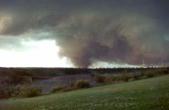
Edmonton Tornado
The Edmonton Tornado, an event also known as Black Friday to Edmontonians, was a powerful and devastating tornado that ripped through the eastern part of Edmonton, Alberta, Canada and parts of neighbouring Strathcona County on the afternoon of Friday, July 31, 1987.The tornado remained on the...
(ranked F4 on the Fujita scale
Fujita scale
The Fujita scale , or Fujita-Pearson scale, is a scale for rating tornado intensity, based primarily on the damage tornadoes inflict on human-built structures and vegetation...
) hit the city and killed 27 people. The storm hit the areas of Beaumont, Mill Woods
Mill Woods
Mill Woods is a residential district in the City of Edmonton, Alberta, Canada. Located in southeast Edmonton, Mill Woods is bounded by Whitemud Drive to the north, 91 Street to the west, 34 Street to the east, and Anthony Henday Drive to the south...
, Bannerman
Bannerman, Edmonton
Bannerman is a residential neighbourhood in the Clareview area of north east Edmonton, Alberta, Canada. It is named after "H. Bannerman, who settled in the Belmont area in 1883."...
, Fraser
Fraser, Edmonton
Fraser is a residential neighbourhood in north east Edmonton, Alberta, Canada. Like many of the neighbourhoods in the Clareview area, it is centred about an elementary school and community hall with the same name...
, and the Evergreen Trailer Park
Evergreen Mobile Home Park, Edmonton
Evergreen Mobile Home Park is a mobile home park located in the rural north east area of the City of Edmonton, Alberta, Canada. In 1987, fifteen people in the park were killed and almost 200 homes were destroyed or damaged beyond repair when the Edmonton Tornado swept through the park at the north...
. The day became known as "Black Friday
Edmonton Tornado
The Edmonton Tornado, an event also known as Black Friday to Edmontonians, was a powerful and devastating tornado that ripped through the eastern part of Edmonton, Alberta, Canada and parts of neighbouring Strathcona County on the afternoon of Friday, July 31, 1987.The tornado remained on the...
."
Then-mayor Laurence Decore
Laurence Decore
Laurence G. Decore, CM was a Ukrainian-Canadian lawyer and politician from Alberta. He was mayor of Edmonton, a member of the Legislative Assembly of Alberta, and leader of the Alberta Liberal Party.- Early life :...
cited the community's response to the tornado as evidence that Edmonton was a "city of champions," which later became the city's official slogan.

Oil refinery
An oil refinery or petroleum refinery is an industrial process plant where crude oil is processed and refined into more useful petroleum products, such as gasoline, diesel fuel, asphalt base, heating oil, kerosene, and liquefied petroleum gas...
remains the basis of many jobs in Edmonton, the city's economy has managed to diversify significantly (e.g., an explosion in high-tech jobs). Downtown Edmonton
Downtown Edmonton
Downtown Edmonton is bounded by 109 Street to the west, 105 Avenue to the north, 97 Street to the east, 97 Avenue, 100 Avenue, and Rossdale Road to the south and Jasper Avenue to the southeast , though many people consider part or all of the surrounding neighborhoods to be part of downtown...
and parts of the inner city
Inner city
The inner city is the central area of a major city or metropolis. In the United States, Canada, United Kingdom and Ireland, the term is often applied to the lower-income residential districts in the city centre and nearby areas...
, after years of extremely high office vacancy rates and neglect, have recovered to a great degree, with office vacancy rates in downtown Edmonton at 5.0%. The downtown area is still undergoing a renaissance of its own, with further new projects underway or about to become reality and more people choosing to live in or near the downtown core (although suburban sprawl is still growing significantly).
In recent years, downtown Edmonton has become much more vibrant, with streets like Jasper Avenue and 104 Street featuring many clubs, shops, restaurants, and galleries. The new Art Gallery of Alberta
Art Gallery of Alberta
The Art Gallery of Alberta is a public art gallery located in downtown Edmonton, Alberta, Canada. Its collection of well over 6,000 works of art includes historical and contemporary paintings, sculptures, installation works and photographs by Canadian and international artists...
is under construction in the downtown core; The first new office tower in 22 years, the EPCOR Tower
EPCOR Tower
EPCOR Tower is an office tower currently under construction in downtown Edmonton, Alberta, Canada that is part of the Station Lands project. The tower is capped by two spires that top out at 137.3 m and these capped with four flagpoles each. When flagpoles are taken into account, it is currently...
, began construction in 2008 and is slated for completion in 2012. The Icon Towers
Icon Towers
The Icon Towers are a complex of two residential towers in downtown Edmonton, Alberta, Canada.The towers are currently Edmonton's tallest residential buildings after they were completed in 2010. The north tower, with 35 floors, has a height of and the south tower, with 30 floors, has a height of ....
(expected completion: 2008 for Tower I, 2009 for Tower II) will be the tallest residential buildings in the city when completed, while many other high-rise condos are still under construction in the downtown core. Due to demand of density outside the core, three neighbourhoods (two just outside of downtown)—Century Park, Glenora
Glenora, Edmonton
Glenora is a prime residential neighbourhood in the city of Edmonton, Alberta, Canada, overlooking the North Saskatchewan River valley.Glenora is bounded on the east by Groat Road, on the north by 107 Avenue, on the west by 142 Street, and on the south by the river valley and the McKinnon Ravine...
, and Strathearn
Strathearn, Edmonton
Strathearn is a roughly triangular shaped residential neighbourhood in south central Edmonton, Alberta, Canada. Most of the development in Strathearn dates to the 1940s and 1950s....
—have proposed new high-rise urban villages.
Also in the outskirts, new subdivisions are being built. These include Tamarack
Tamarack, Edmonton
Tamarack is a newer residential neighborhood in south east Edmonton, Alberta.It is bounded on the south by 23 Avenue, on the north by Whitemud Drive, on the west by 17 Street and on the east by Fulton Nature Reserve and undeveloped spaces...
, Lewis Estates, Cameron Heights
Cameron Heights, Edmonton
Cameron Heights is a new neighbourhood in west Edmonton, Alberta, Canada overlooking the North Saskatchewan River valley.It is bounded on the south by Anthony Henday Drive, on the north and west by a ravine, and on the east by the North Saskatchewan River valley...
, Windermere
Windermere Estates, Edmonton
Windermere Estates is a neighbourhood in southwest Edmonton, Alberta, Canada, overlooking the North Saskatchewan River valley.It is bounded on the south by the future realignment of Ellerslie Road, on the east by 170 Street SW/Terwillegar Drive, on the northeast by Anthony Henday Drive, and on the...
, Ellerslie
Ellerslie, Edmonton
Ellerslie is a newer residential neighbourhood in south Edmonton, Alberta, Canada.The most common type of residence in the neighbourhood is the single family dwelling. According to the 2005 municipal census, two out of every three residences were single-family dwellings...
and many more, as well as new power centres such as The Meadows and Windermere.
This economic prosperity is bringing in large numbers of workers from all over Canada. It is forecast that 83,000 new residents will move to Edmonton between 2006 and 2010, twice the rate that city planners had expected. Many of the new workers moving to the city are young men.
In 2008 the Edmonton region population surpasses one million becoming the most northern city in North America
North America
North America is a continent wholly within the Northern Hemisphere and almost wholly within the Western Hemisphere. It is also considered a northern subcontinent of the Americas...
with a population over one million.