

Northwest Staging Route
Encyclopedia
The Northwest Staging Route was a series of airstrips, airport
Airport
An airport is a location where aircraft such as fixed-wing aircraft, helicopters, and blimps take off and land. Aircraft may be stored or maintained at an airport...
and radio ranging stations built in Alberta
Alberta
Alberta is a province of Canada. It had an estimated population of 3.7 million in 2010 making it the most populous of Canada's three prairie provinces...
, British Columbia
British Columbia
British Columbia is the westernmost of Canada's provinces and is known for its natural beauty, as reflected in its Latin motto, Splendor sine occasu . Its name was chosen by Queen Victoria in 1858...
, the Yukon
Yukon
Yukon is the westernmost and smallest of Canada's three federal territories. It was named after the Yukon River. The word Yukon means "Great River" in Gwich’in....
and Alaska
Alaska
Alaska is the largest state in the United States by area. It is situated in the northwest extremity of the North American continent, with Canada to the east, the Arctic Ocean to the north, and the Pacific Ocean to the west and south, with Russia further west across the Bering Strait...
during World War II
World War II
World War II, or the Second World War , was a global conflict lasting from 1939 to 1945, involving most of the world's nations—including all of the great powers—eventually forming two opposing military alliances: the Allies and the Axis...
. It was known in the Soviet Union as Alsib (ALaska-SIBerian air road).
Origins
The route was developed in 1942 due to several reasons. Initially, the United States Army Air Corps 7th Ferrying Group, Ferrying Command (later Air Transport CommandAir Transport Command
Air Transport Command is an inactive United States Air Force unit. Its mission was to meet the urgent demand for the speedy reinforcement of the United States' military bases worldwide during World War II, using an air supply system to supplement surface transport...
) at Great Falls Army Airfield was ordered to organize and develop an air route to send assistance to Russia though northwestern Canada, across Alaska and the Bering Sea to Siberia, and eventually over to the Eastern Front. Late in 1941, the Permanent Joint Board on Defense — Canada and the United States — decided in the autumn of 1940 that a string of airports should be constructed at Canadian expense between the city of Edmonton in central Alberta and the Alaska-Yukon border. Late in 1941 the Canadian government reported that rough landing fields had been completed.
With the outbreak of war, American lines of communication with Alaska by sea were seriously threatened and alternative routes had to be opened. The string of airports through the lonely tundra and forests of northwest Canada provided an air route to Alaska which was practically invulnerable to attack, and it seemed to be in the best interests of international defense to develop them and open a highway which would at once be a service road for the airports and a means for transporting essential supplies to our Alaskan outposts. In response to this need, United States Army engaged in the Alaskan Highway project.
Neither the Eleventh Air Force and United States Army military installations could wait for the Alaska Highway to be completed. Nor could Lend-Lease aid to the Soviet Union. The long route though the Caribbean to Brazil and across Africa to Iran was unworkable, nor could aircraft be flown via Greenland or Iceland. A huge program of airport construction and road making, therefore, was undertaken.
The Alaska Highway was but a part of the defenses provided for the Northwest North American frontier. Much less is known about the great air route leading from the United States to Alaska through Canada. Airfields were built or upgraded every 100 mi (160.9 km) or so from Edmonton, Alberta
Edmonton
Edmonton is the capital of the Canadian province of Alberta and is the province's second-largest city. Edmonton is located on the North Saskatchewan River and is the centre of the Edmonton Capital Region, which is surrounded by the central region of the province.The city and its census...
to Fairbanks, Alaska
Fairbanks, Alaska
Fairbanks is a home rule city in and the borough seat of the Fairbanks North Star Borough in the U.S. state of Alaska.Fairbanks is the largest city in the Interior region of Alaska, and second largest in the state behind Anchorage...
("the longest hop being the 140 miles or so between Fort Nelson
Fort Nelson, British Columbia
Fort Nelson is a town of approximately 5000 residents in British Columbia's northeastern corner. It is the administrative centre of the newly formed Northern Rockies Regional Municipality, a first for BC. The majority of Fort Nelson's economic activities have historically been concentrated in the...
and the Liard River
Watson Lake, Yukon
Watson Lake is a town at historical mile 635 on the Alaska Highway in the southeastern Yukon close to the British Columbia border. Population in December 2004 was 1,547 ....
flight strip"). The route of the Alaska Highway
Alaska Highway
The Alaska Highway was constructed during World War II for the purpose of connecting the contiguous U.S. to Alaska through Canada. It begins at the junction with several Canadian highways in Dawson Creek, British Columbia and runs to Delta Junction, Alaska, via Whitehorse, Yukon...
, which was built to provide a land route to Alaska, basically connected the airfields together. Edmonton became the headquarters of the Alaskan Wing, Air Transport Command.
Two routes were developed from the United States, which met at Edmonton, Alberta
Edmonton
Edmonton is the capital of the Canadian province of Alberta and is the province's second-largest city. Edmonton is located on the North Saskatchewan River and is the centre of the Edmonton Capital Region, which is surrounded by the central region of the province.The city and its census...
, from which the aircraft were ferried to Ladd Field
Ladd Field
Ladd Army Airfield is the military airfield located at Fort Jonathan Wainwright, located in Fairbanks, Alaska. It was originally called Fairbanks Air Base, but was renamed Ladd Field on 1 December 1939, in honor of Major Arthur K. Ladd, a pilot in the U.S. Army Air Corps who died in a plane crash...
, near Fairbanks, Alaska
Fairbanks, Alaska
Fairbanks is a home rule city in and the borough seat of the Fairbanks North Star Borough in the U.S. state of Alaska.Fairbanks is the largest city in the Interior region of Alaska, and second largest in the state behind Anchorage...
where the American-built aircraft were to be turned over to Russian flight crews. Marks Army Airfield, near Nome, Alaska
Nome, Alaska
Nome is a city in the Nome Census Area in the Unorganized Borough of the U.S. state of Alaska, located on the southern Seward Peninsula coast on Norton Sound of the Bering Sea. According to the 2010 Census, the city population was 3,598. Nome was incorporated on April 9, 1901, and was once the...
was 500 miles closer to Russia, but was ruled out because the United States feared it was too vulnerable to Japanese attack. One route originated at Great Falls Army Air Base, Montana, where aircraft bound for Russia were ferried from their manufacturing plants in Southern California
Southern California
Southern California is a megaregion, or megapolitan area, in the southern area of the U.S. state of California. Large urban areas include Greater Los Angeles and Greater San Diego. The urban area stretches along the coast from Ventura through the Southland and Inland Empire to San Diego...
. The other route originated at Minneapolis, Minnesota
Minneapolis, Minnesota
Minneapolis , nicknamed "City of Lakes" and the "Mill City," is the county seat of Hennepin County, the largest city in the U.S. state of Minnesota, and the 48th largest in the United States...
, where Wold-Chamberlain Airport
Minneapolis-Saint Paul International Airport
Minneapolis-Saint Paul International Airport is the largest and busiest airport in the five-state upper Midwest region of Minnesota, Iowa, South Dakota, North Dakota, and Wisconsin.-Overview:...
was used as an aircraft staging point for aircraft manufactured in the Midwest and northeastern United States. The Minneapolis-Edmonton route, however was turned into a transport route only by the end of 1943, with aircraft ferrying operations being shifted to Great Falls. In addition to the Lend-Lease aircraft, Alaskan Eleventh Air Force
Eleventh Air Force
The Eleventh Air Force is a numbered air force of the United States Air Force Pacific Air Forces . It is headquartered at Elmendorf Air Force Base, Alaska....
aircraft were also ferried up the NSR, with the aircraft being flown to Elmendorf Field, near Anchorage from RCAF Station Whitehorse
RCAF Station Whitehorse
RCAF Station Whitehorse was originally opened by the Department of Transport as "Whitehorse airfield". It is located at what is now the Erik Nielsen Whitehorse International Airport....
upon their arrival.
Aircraft
Four main types of aircraft were ferried to the Soviet Union under Lend-Lease. BellBell Aircraft
The Bell Aircraft Corporation was an aircraft manufacturer of the United States, a builder of several types of fighter aircraft for World War II but most famous for the Bell X-1, the first supersonic aircraft, and for the development and production of many important civilian and military helicopters...
P-39 Aircobras, and later its P-63 Kingcobra
P-63 Kingcobra
The Bell P-63 Kingcobra was a United States fighter aircraft developed in World War II from the Bell P-39 Airacobra in an attempt to correct that aircraft's deficiencies...
successor fighter, which was favored by the Red Air Force who used it with great success. The majority of the P-39s shipped to the Soviet Union were the highly developed Q-models. The Douglas
Douglas Aircraft Company
The Douglas Aircraft Company was an American aerospace manufacturer, based in Long Beach, California. It was founded in 1921 by Donald Wills Douglas, Sr. and later merged with McDonnell Aircraft in 1967 to form McDonnell Douglas...
A-20 Havoc light attack bomber and North American
North American Aviation
North American Aviation was a major US aerospace manufacturer, responsible for a number of historic aircraft, including the T-6 Texan trainer, the P-51 Mustang fighter, the B-25 Mitchell bomber, the F-86 Sabre jet fighter, the X-15 rocket plane, and the XB-70, as well as Apollo Command and Service...
B-25 Mitchell
B-25 Mitchell
The North American B-25 Mitchell was an American twin-engined medium bomber manufactured by North American Aviation. It was used by many Allied air forces, in every theater of World War II, as well as many other air forces after the war ended, and saw service across four decades.The B-25 was named...
medium bombers were also sent to the Red Air Force. Douglas C-47 Skytrain
C-47 Skytrain
The Douglas C-47 Skytrain or Dakota is a military transport aircraft that was developed from the Douglas DC-3 airliner. It was used extensively by the Allies during World War II and remained in front line operations through the 1950s with a few remaining in operation to this day.-Design and...
transports were also supplied in great numbers. The Bell fighters and the B-25 Mitchells were flown up to Ladd via Minneapolis; the C-47s and A-20s came up via Great Falls. A handful of other aircraft types, AT-6 Texans, some North American P-40 Warhawks and three Republic P-47 Thunderbolt
P-47 Thunderbolt
Republic Aviation's P-47 Thunderbolt, also known as the "Jug", was the largest, heaviest, and most expensive fighter aircraft in history to be powered by a single reciprocating engine. It was heavily armed with eight .50-caliber machine guns, four per wing. When fully loaded, the P-47 weighed up to...
s and one C-46 Commando
C-46 Commando
The Curtiss-Wright C-46 Commando was a transport aircraft originally derived from a commercial high-altitude airliner design. It was instead used as a military transport during World War II by the United States Army Air Forces as well as the U.S. Navy/Marine Corps under the designation R5C...
were also ferried to Russia. The aircraft were supplied with Russian language operations and maintenance manuals; as well as painted in Red Air Force camouflage colors and national markings.
The Russians set up a command at Ladd Field
Ladd Field
Ladd Army Airfield is the military airfield located at Fort Jonathan Wainwright, located in Fairbanks, Alaska. It was originally called Fairbanks Air Base, but was renamed Ladd Field on 1 December 1939, in honor of Major Arthur K. Ladd, a pilot in the U.S. Army Air Corps who died in a plane crash...
and Nome where their pilots were trained to take over the aircraft and fly them to Novosibirsk
Novosibirsk
Novosibirsk is the third-largest city in Russia, after Moscow and Saint Petersburg, and the largest city of Siberia, with a population of 1,473,737 . It is the administrative center of Novosibirsk Oblast as well as of the Siberian Federal District...
in Siberia and on to various fronts in western Russia. The first group of Russian pilots arrived at Nome on 14 August 1942 on their way to Ladd Field. Along with the pilots were civilians from the Soviet Purchasing Commission and a group of Red Air Force mechanics. Most were located at Ladd, with a secondary group at Marks Field. The first Lend-Lease aircraft, a group of twelve A-20 Havocs, arrived at Ladd on 3 September 1942. The first Russian pilots, after five days of training on the aircraft, took off for Nome and the long trip to the Eastern Front. Initially the USAAF provided the initial training on how to operate and maintain the Lend-Lease aircraft. Later, after an experienced cadre was developed, the Russians assumed the responsibility. The Russians also meticulously inspected each aircraft, and would reject any aircraft that presented the slightest problem. The USAAF was then left with the chore of correcting them. It was sometimes quite exasperating, as the USAAF would work long hours of overtime to get the aircraft into first-class condition so that all the Russians had to do was fly them from Fairbanks to the Eastern Front.
Other uses
The ALSIB and Northwest Staging Route also provided a diplomatic route between Washington, D.C. and Moscow. Diplomats, high political figures and countless other government officials shuttled back and forth along it in transports during the war. Wendell WillkieWendell Willkie
Wendell Lewis Willkie was a corporate lawyer in the United States and a dark horse who became the Republican Party nominee for the president in 1940. A member of the liberal wing of the GOP, he crusaded against those domestic policies of the New Deal that he thought were inefficient and...
, Vice-President Henry A. Wallace
Henry A. Wallace
Henry Agard Wallace was the 33rd Vice President of the United States , the Secretary of Agriculture , and the Secretary of Commerce . In the 1948 presidential election, Wallace was the nominee of the Progressive Party.-Early life:Henry A...
, Soviet Foreign Minister Vyacheslav Molotov
Vyacheslav Molotov
Vyacheslav Mikhailovich Molotov was a Soviet politician and diplomat, an Old Bolshevik and a leading figure in the Soviet government from the 1920s, when he rose to power as a protégé of Joseph Stalin, to 1957, when he was dismissed from the Presidium of the Central Committee by Nikita Khrushchev...
, and Andrei Gromyko
Andrei Gromyko
Andrei Andreyevich Gromyko was a Soviet statesman during the Cold War. He served as Minister of Foreign Affairs and as Chairman of the Presidium of the Supreme Soviet . Gromyko was responsible for many top decisions on Soviet foreign policy until he retired in 1987. In the West he was given the...
were but a few who used the route. President Roosevelt considered holding a summit in Fairbanks in 1944 to meet with Stalin, however the location was subsequently changed to Yalta. Also the route provided a means over which the Russians moved intelligence agents and classified information obtained illegally in the United States. The Soviets, claiming diplomatic immunity routinely moved large numbers of suitcases in batches of 50 or more, their contents diplomatically sealed.
The Russians who arrived in Alaska also frequently visited shopping areas in Fairbanks and Nome, and contingents visited the aircraft manufacturing plants in the United States. They maintained a strict decorum and politely paid for their purchases, sometimes in old US Gold Certificates. Many luxury items were bought and shipped back to the Soviet Union on the Lend-Lease aircraft with the hope that they would reach their final destinations in Russia. Most of the Russian pilots were experienced combat veterans who saw the ferrying mission as a respite from their combat missions. They were generally reserved and Political officers were sent to Alaska to ensure their loyalty.
Termination
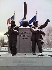
As the Pacific War wound down, the wartime marriage between the capitalistic and communist countries was coming to an end. In 1945, the United States and Soviet Union were about to embark on a cold war and the Russians departed Fairbanks shortly after the Japanese Capitulation in September 1945.Possibly because of their strict inspection standards, and also in spite of the Russian methods of flying them, there were remarkably few aircraft accidents. During the twenty-one months of the program, 7,983 planes were delivered to the Russians with only 133 lost to weather or pilot error.Thirteen Red Air Force pilots were buried in the Fort Richardson cemetery.
Airfields
Primary airfields in BOLD| Name | Location | Coordinates | Notes |
|---|---|---|---|
| Gambell Army Airfield Gambell Airport Gambell Airport is a public airport located in Gambell, a city in the Nome Census Area of the U.S. state of Alaska. The airport is owned by the state.-Facilities:... |
AK | 63°46′04"N 171°43′59"W | Final refueling stop prior to aircraft being flown into Soviet airspace |
| Marks Army Airfield Nome Airport Nome Airport is a state-owned public-use airport located two nautical miles west of the central business district of Nome, a city in the Nome Census Area of the U.S... |
AK | 64°30′44"N 165°26′43"W | Final servicing point for aircraft; 1469th AAFBU ATC Alaskan Division. |
| Galena Airport Edward G. Pitka Sr. Airport Edward G. Pitka Sr. Airport is a state-owned public-use airport located in Galena, a city in the Yukon-Koyukuk Census Area of the U.S. state of Alaska.-Facilities:Edward G. Pitka Sr... |
AK | 64°44′10"N 156°56′04"W | Refueling/servicing airfield; 1468th AAFBU ATC Alaskan Division. |
| Ladd Army Airfield | AK | 64°50′15"N 147°36′51"W | Was main transfer point for Lend-Lease aircraft from United States ATC pilots to Soviet Red Air Force pilots; aircraft then flown to Siberia after transfer. |
| Mile 26 Field Eielson Air Force Base Eielson Air Force Base is a United States Air Force base located approximately southeast of Fairbanks, Alaska and just southeast of Moose Creek, Alaska.... |
AK | 64°39′55"N 147°06′02"W | Axillary for Ladd AAB |
| Big Delta Army Airfield Allen Army Airfield Allen Army Airfield is a public/military airport serving Fort Greely and located three miles south of the central business district of Delta Junction, a city in the Southeast Fairbanks Census Area of the U.S. state of Alaska... |
AK | 63°59′42"N 145°43′12"W | Refueling/servicing airfield; 1464th AAFBU ATC Alaskan Division. |
| Tanacross Air Base Tanacross Airport Tanacross Airport is a general aviation airport located southeast of Fairbanks, Alaska.-History:Constructed 1943, activated 20 September by Air Transport Command as Station #16, Alaskan Wing, later 1464th AAFBU. Alaskan Division, ATC. Was auxiliary to Ladd Army Airfield for Northwest Staging... |
AK | 63°22′25"N 143°20′00"W | Refueling/servicing airfield; 1464th AAFBU ATC Alaskan Division. |
| Northway Army Airfield Northway Airport Northway Airport is a state-owned public-use airport located in Northway, in the Southeast Fairbanks Census Area of the U.S. state of Alaska.As per Federal Aviation Administration records, this airport had 55 commercial passenger boardings in calendar year 2010, an increase of 511% from the 9... |
AK | 62°57′40"N 141°55′50"W | Refueling/servicing airfield; 1463d AAFBU ATC Alaskan Division. |
| Beaver Creek Beaver Creek Airport Beaver Creek Airport is located northwest of Beaver Creek, Yukon, Canada, and is operated by the Yukon government. The gravel runway is long and is at an elevation of .... |
YT | 62°24′43"N 140°52′06"W | Emergency landing strip, constructed 1941 by Canadian government |
| Snag Snag, Yukon Snag is a village located on a small, dry-weather sideroad off the Alaska Highway south of Beaver Creek, Yukon, Canada. The village of Snag is located in a bowl-shaped valley of the White River and its tributaries, including Snag Creek. It was first settled during the Klondike Gold Rush. An... |
YT | 62°21′12"N 140°24′15"W | Emergency landing strip, constructed 1941 by Canadian government |
| Burwash Landing Burwash Airport Burwash Airport is located northwest of Burwash Landing, Yukon, Canada, and is operated by the Yukon government.- External links :** on COPA's Places to Fly airport directory... |
YT | 61°22′13"N 139°02′22"W | Emergency landing strip, constructed 1941 by Canadian government |
| Silver City | YT | 61°01′49"N 138°24′17"W | Emergency landing strip, constructed 1941 by Canadian government |
| Aishihik Aishihik, Yukon Aishihik is a mostly uninhabited former Indian settlement at the north end of Aishihik Lake in Canada's Yukon. Until 1968, it was the location of a military airfield established during World War II as part of the Northwest Staging Route. The withdrawal of military service led to the community's... |
YT | 61°38′56"N 137°29′18"W | Abandoned, Emergency airstrip, constructed 1941 by Canadian government |
| Pine Lake | YT | 60°47′22"N 137°32′33"W | Auxiliary refueling/servicing airfield, constructed 1941 by Canadian government |
| Champagne | YT | 60°47′17"N 136°28′33"W | Emergency landing strip, constructed 1941 by Canadian government |
| Cousins Whitehorse/Cousins Airport Whitehorse/Cousins Airport is an unpaved airstrip located in Whitehorse, Yukon, Canada, northwest of the city centre between the Alaska Highway and the Yukon River. This airport has no services at all, and is used primarily as an emergency landing area and for local pilot training. Vehicles enter... |
YT | 60°48′43"N 135°10′57"W | Emergency landing strip |
| RCAF Station Whitehorse | YT | 60°42′45"N 135°04′09"W | Refueling/servicing airfield; 1462d AAFBU ATC Alaskan Division; also known as Whitehorse Army Air Base. Remained as joint RCAF/USAF base until about 1949; hosted Det.3, 1701st Air Transport Wing (MATS) |
| Squanga Lake Johnsons Crossing, Yukon Johnson's Crossing is a settlement in the Yukon territory of Canada, located at historical mile 836 of the Alaska Highway, at the junction of the Canol Road where the highway crosses the Teslin River. The community had a population of 15 in the Canada 2006 Census.-Climate:... |
YT | 60°29′10"N 133°27′25"W | Emergency landing strip |
| Teslin Lake Teslin Airport Teslin Airport is located on the northwest side of Teslin, Yukon, Canada, and is operated by the Yukon government. The gravel runway is long and is at an elevation of .-External links:*... |
YT | 60°10′22"N 132°44′26"W | Emergency landing strip |
| Pine Lake Swift River, Yukon Swift River is a settlement in the Canadian territory of Yukon, primarily a service stop on the Alaska Highway at historical mile 733. The only permanent population owns and operates, or is employed at, the area's commercial highway establishment... |
YT | 60°06′11"N 130°56′00"W | Emergency landing strip |
| Watson Lake/Liard River Watson Lake Airport Watson Lake Airport is located west of Watson Lake, Yukon, Canada, and is operated by the Yukon government. The paved asphalt runway is long and is at an elevation of .... |
YT | 60°06′31"N 128°50′51"W | Refueling/servicing airfield; 1461st AAFBU ATC Alaskan Division. |
| Smith River Smith River, British Columbia Smith River is an unincorporated settlement in the Liard Country of far northern British Columbia, Canada. It is located southwest of the junction of Shaw Creek with the Smith River, which enters the Liard between the confluences of the Toad and Coal Rivers.... |
BC | 59°53′30"N 126°25′46"W | Emergency landing strip |
| Fort Nelson Fort Nelson Airport Fort Nelson Airport, , is located east northeast of Fort Nelson, British Columbia, Canada.-Airlines and destinations:-See also:*Fort Nelson Water Aerodrome*Fort Nelson/Gordon Field Airport*Fort Nelson/Mobil Sierra Airport... |
BC | 58°50′17"N 122°35′48"W | Was main refueling/servicing point on route; 1460th AAFBU ATC Alaskan Division. Remained as joint RCAF/USAF base until about 1949; hosted Det.2, 1701st Air Transport Wing (MATS) |
| Prophet River Prophet River, British Columbia Prophet River is a First Nations reserve community of the Dunne-za people in northeastern British Columbia, Canada, located at Mile 233 on Highway 97, the Alaska Highway, about 54 miles south of Fort Nelson. The community observes Mountain Standard Time year-round, while Fort Nelson observes... |
BC | 57°57′47"N 122°47′18"W | Emergency landing strip |
| Beatton River | BC | 57°22′48"N 121°24′41"W | Emergency landing strip |
| Sikanni Chief Sikanni Chief, British Columbia Sikanni Chief is an unincorporated locality in the Northern Rocky Mountains of British Columbia, Canada. It is located on the north bank of the Sikanni Chief River, at an elevation of .... |
BC | 57°05′21"N 122°36′18"W | Emergency landing strip |
| Fort St. John | BC | 56°14′14"N 120°44′24"W | Refueling/servicing airfield; 1459th AAFBU ATC Alaskan Division. |
| RCAF Station Dawson Creek Dawson Creek Airport Dawson Creek Airport, , is located southeast of Dawson Creek, British Columbia, Canada.Ian Darling is the Airport Manager.-Airlines and destinations:-External links:* on COPA's Places to Fly airport directory... |
BC | 55°44′31"N 120°11′06"W | Auxiliary refueling/servicing airfield |
| Beaverlodge Beaverlodge Airport Beaverlodge Airport, is located south of Beaverlodge, Alberta, Canada. It is home to the Grande Prairie Soaring Society.-External links:* on COPA's Places to Fly airport directory*... |
AB | 55°11′04"N 119°26′52"W | Emergency landing strip |
| Grande Prairie Grande Prairie Airport Grande Prairie Airport is located west northwest of Grande Prairie, Alberta, Canada. It is the largest airport in the Peace River Country of northwestern Alberta and northeastern British Columbia, having served 330,009 passengers in 2006, and having 358,905 passengers through its gates in 2007... |
AB | 55°10′55"N 118°52′55"W | Refueling/servicing airfield; 1457th AAFBU ATC Alaskan Division. |
| DeBolt | AB | 55°14′06"N 118°02′19"W | Emergency landing strip |
| Valleyview Valleyview Airport Valleyview Airport, , is located south of Valleyview, Alberta, Canada.-External links:* on COPA's Places to Fly airport directory... |
AB | 55°01′58"N 117°17′42"W | Emergency landing strip |
| Fox Creek Fox Creek Airport Fox Creek Airport, , is located southeast of Fox Creek, Alberta, Canada.-External links:* on COPA's Places to Fly airport directory... |
AB | 54°22′48"N 116°46′00"W | Emergency landing strip |
| Whitecourt Whitecourt Airport Whitecourt Airport, , is located west of Whitecourt, Alberta, Canada.The Whitecourt Airport was opened in 1978. It is serviced by three non-precision IFR approaches. The approach lighting consists of PAPI3 and medium intensity runway lighting.... |
AB | 54°08′37"N 115°47′16"W | Emergency landing strip |
| Mayerthorpe Mayerthorpe Airport Mayerthorpe Airport, , is located southwest of Mayerthorpe, Alberta, Canada.... |
AB | 53°56′13"N 115°10′41"W | Emergency landing strip |
| Birch Lake Glenevis, Alberta Glenevis is a hamlet in central Alberta, Canada within Lac Ste. Anne County. It is located on Highway 43, approximately northwest of Edmonton.- References :... |
AB | 53°46′16"N 114°33′43"W | Auxiliary airfield; now abandoned and obliterated |
| RCAF Station Namao CFB Edmonton CFB Edmonton is a Canadian Forces base located in Edmonton, Alberta, Canada. It is also known as Edmonton Garrison or "Steele Barracks".-History:... |
AB | 53°40′27"N 113°28′29"W | Opened 1 November 1944. Additional Hub/refueling/servicing airfield in Edmonton. Remained as joint RCAF/USAF base until about 1949; hosted Det.1, 1701st Air Transport Wing (MATS) |
| RCAF Station Edmonton Edmonton City Centre (Blatchford Field) Airport Edmonton City Centre Airport, , is located within the city of Edmonton, Alberta, Canada. It is bordered by Yellowhead Trail to the north, Kingsway to the south, 121 Street to the west, and the Northern Alberta Institute of Technology to the east. It encompasses approximately of land just north... |
AB | 53°34′26"N 113°31′30"W | Activated 17 October 1942. Was HQ, Alaskan Wing, ATC; Hub/refueling/servicing airfield; 1450th/1451st/1452d AAFBU. |
| Great Falls-Edmonton | |||
| Ponoka Ponoka Industrial (Labrie Field) Airport Ponoka Industrial Airport, , is located southwest of Ponoka, Alberta, Canada.-External links:* on COPA's Places to Fly airport directory... |
AB | 52°39′07"N 113°36′15"W | Emergency landing strip |
| Lacombe Lacombe Airport Lacombe Airport, , is located northeast of Lacombe, Alberta, Canada.-External links:* on COPA's Places to Fly airport directory... |
AB | 52°29′17"N 113°42′42"W | Emergency landing strip |
| RCAF Station Penhold Red Deer Regional Airport Red Deer Regional Airport, , is located south southwest of Red Deer, Alberta, Canada. The airport is mostly general aviation and charter service, but is also served by two small scheduled commercial airlines, with non-stop service to Calgary, Edmonton, and several small communities in Alberta... |
AB | 52°10′42"N 113°53′21"W | Auxiliary refueling/servicing airfield (now Red Deer Regional Airport) |
| Innisfail Innisfail Airport Innisfail Airport , , is located northwest of Innisfail, Alberta, Canada.It offers one asphalt runway equipped with night landing lights. The two other runway surfaces are in rough condition. There are several hangars at the airport and room for more development... |
AB | 51°58′42"N 114°00′34"W | Emergency landing strip |
| Olds Olds-Didsbury Airport Olds-Didsbury Airport, , is located next to Alberta Highway 2A, south of the Town of Olds, Alberta and north of the Town of Didsbury, Alberta, Canada.-External links:* on COPA's Places to Fly airport directory... |
AB | 51°42′39"N 114°06′20"W | Auxiliary refueling/servicing airfield |
| Carstairs Carstairs/Bishell's Airport Carstairs/Bishell's Airport, , is located northeast of Carstairs, Alberta, Canada.-External links:* on COPA's Places to Fly airport directory... |
AB | 51°34′50"N 114°03′08"W | Emergency landing strip |
| Airdrie Calgary/Airdrie Airport Airdrie Airport or Calgary/Airdrie Airport, , is a registered aerodrome located southeast of Airdrie, Alberta, Canada.-Airdrie Regional Airshow:... |
AB | 51°15′52"N 113°56′10"W | Auxiliary refueling/servicing airfield |
| Calgary Calgary International Airport Calgary International Airport, , is the international airport that serves Calgary, Alberta, Canada and the surrounding region; it is situated approximately northeast of downtown Calgary... |
AB | 51°07′15"N 114°01′17"W | Refueling/servicing airfield; 1457th AAFBU ATC Alaskan Division. |
| Okotoks Calgary/Okotoks Air Park Okotoks Air Park, , is located south of Calgary, Alberta, Canada.-References:* on COPA's Places to Fly airport directory... |
AB | 50°44′06"N 113°56′04"W | Emergency airstrip |
| High River High River Airport High River Regional Airport, , is a registered aerodrome located south southeast of High River, Alberta, Canada.-External links:* * * on COPA's Places to Fly airport directory... |
AB | 50°32′02"N 113°50′36"W | Auxiliary refueling/servicing airfield |
| Nanton Nanton, Alberta Nanton is a town in southern Alberta, Canada. Nanton was named after Sir Augustus Meredith Nanton, of Winnipeg who directed firms that offered financing for farms and ranches throughout the west... |
AB | 50°22′19"N 113°39′42"W | 2 x 2000 ft (609.6 m) runway auxiliary refueling/servicing airfield, now abandoned and obliterated as farmland |
| RCAF Station Claresholm Claresholm Industrial Airport Claresholm Industrial Airport is located south southwest of Claresholm, Alberta, Canada.The airport opened in 1941 as RCAF Station Claresholm as part of the British Commonwealth Air Training Plan and closed in 1945. In 1951 it was reopened as a NATO training centre and closed again in 1958 when... |
AB | 50°00′10"N 113°37′38"W | Axillary refueling/servicing airfield (now Claresholm Industrial Airport) |
| RCAF Station Lethbridge Lethbridge County Airport Lethbridge County Airport or Lethbridge Airport, , is located south southeast of Lethbridge, Alberta, Canada. It is 10-15 driving minutes from the downtown area and has scheduled service to the Alberta cities of Calgary and Edmonton. The airport is classified as an airport of entry by NAV CANADA... |
AB | 49°37′47"N 112°47′23"W | Axillary refueling/servicing airfield (now Lethbridge County Airport) |
| Shelby Shelby, Montana Shelby is a city in and the county seat of Toole County, Montana, United States. The population was 3,216 at the 2000 census.-Geography:Shelby is located at .... |
MT | 48°32′27"N 111°52′12"W | Auxiliary refueling/servicing airfield |
| Conrad Conrad, Montana Conrad is a city in and the county seat of Pondera County, Montana, United States. The population was 2,753 at the 2000 census.-Geography:Conrad is located at .... |
MT | 48°10′06"N 111°58′33"W | Auxiliary refueling/servicing airfield |
| Gore Army Airfield Great Falls International Airport Great Falls International Airport is a joint civil-military public airport located within city limits, three miles southwest of central Great Falls in Cascade County, Montana, USA... |
MT | 47°29′02"N 111°22′21"W | 557th AAFBU, Ferrying Division, ATC; Group assembly and dispatch airfield for Lend-lease aircraft (now Great Falls International Airport) |
| Great Falls Army Air Base Malmstrom Air Force Base Malmstrom Air Force Base is a United States Air Force base and census-designated place in Cascade County, Montana, United States. It was named in honor of World War II POW Colonel Einar Axel Malmstrom... |
MT | 47°30′28"N 111°11′03"W | HQ, Northwest Sector, Domestic Wing, ATC; Group assembly and servicing airfield for Lend-lease aircraft; passenger point of Embarkation (now Malmstrom Air Force Base) |
| Minneapolis-Edmonton | |||
| Vegreville Vegreville Airport Vegreville Airport, , is located adjacent to Vegreville, Alberta, Canada.-External links:* on COPA's Places to Fly airport directory... |
AB | 53°30′45"N 112°01′36"W | Emergency landing airfield |
| Vermillion | AB | 53°21′23"N 110°49′40"W | Emergency landing airfield |
| Lloydminster Lloydminster Airport Lloydminster Airport, , is located northwest of Lloydminster, Alberta, Canada.-History:Built in 1981 to replace the previous Lloydminster Airport, the new airport serves as the largest airport in the region... |
SK | 53°17′49"N 110°00′00"W | Emergency landing airfield (closed about 1981 now abandoned, replaced by new airport on Alberta side of border) |
| RCAF Station North Battleford North Battleford (Cameron McIntosh) Airport North Battleford Airport, , is located east of North Battleford, Saskatchewan, Canada. The airport is named after Cameron Ross McIntosh, previously the airport was the site of RCAF Station North Battleford... |
SK | 52°46′06"N 108°14′32"W | Refueling/servicing airfield (now North Battleford (Cameron McIntosh) Airport) |
| RCAF Station Saskatoon RCAF Station Saskatoon RCAF Station Saskatoon was a World War II British Commonwealth Air Training Plan base operated by the Royal Canadian Air Force . It was located at Saskatoon, Saskatchewan, Canada.... |
SK | 52°10′15"N 106°41′59"W | Refueling/servicing airfield (now Saskatoon John G. Diefenbaker International Airport) |
| Humboldt Humboldt Airport Humboldt Airport, , is located south of Humboldt, Saskatchewan, Canada.... |
SK | 52°10′31"N 105°08′01"W | Emergency landing airfield |
| Yorkton Yorkton Municipal Airport Yorkton Municipal Airport, , is located north of Yorkton, Saskatchewan, Canada.-History:During World War II Yorkton Airport was home to No. 23 Elementary Flying Training School and No. 11 Service Flying Training School - both schools being a part of the British Commonwealth Air Training Plan... |
SK | 51°15′54"N 102°27′42"W | Refueling/servicing airfield |
| Russell Russell Airport Russell Airport, , is located adjacent to Russell, Manitoba, Canada.-External links:* on COPA's Places to Fly airport directory... |
MB | 50°45′55"N 101°17′39"W | Emergency landing airfield |
| Shoal Lake Shoal Lake Airport Shoal Lake Airport, , is located northwest of Shoal Lake, Manitoba, Canada.... |
MB | 50°27′25"N 100°36′34"W | Emergency landing airfield |
| Minnedosa Minnedosa Airport Minnedosa Airport, , is located northeast of Minnedosa, Manitoba, Canada.... |
MB | 50°16′21"N 099°45′50"W | Emergency landing airfield |
| Neepawa Neepawa Airport Neepawa Airport, , is located west of Neepawa, Manitoba, Canada.... |
MB | 50°13′56"N 099°30′38"W | Refueling/servicing airfield |
| RCAF Station Portage La Prairie Portage La Prairie/Southport Airport Portage la Prairie/Southport Airport, , is located adjacent to Portage la Prairie, Manitoba, Canada. It is the Southport Aerospace Centre, a commercial-industrial centre.. It is now commercially operated. It was formerly Canadian Forces Base Portage la Prairie.... |
MB | 49°54′11"N 098°16′26"W | Refueling/servicing airfield (now Portage la Prairie/Southport Airport) |
| RCAF Station Winnipeg CFB Winnipeg Canadian Forces Base Winnipeg , is a Canadian Forces Base located within the City of Winnipeg, Manitoba. Co-located at the Winnipeg James Armstrong Richardson International Airport, CFB Winnipeg is home to many flight operations support divisions, as well as several training schools... |
MB | 49°53′20"N 97°14′05"W | Refueling/servicing airfield (now CFB Winnipeg) |
| Grand Forks Grand Forks Municipal Airport Grand Forks Municipal Airport is a former airport, located within current city limits approximately west-northwest of central Grand Forks, North Dakota. It was closed shortly after World War II and is now redeveloped as part of the urban area of Grand Forks.... |
ND | 47°55′44"N 097°06′02"W | Refueling/servicing airfield (note: NOT the current Grand Forks International Airport Grand Forks International Airport Grand Forks International Airport is a public airport located five miles northwest of the central business district of Grand Forks, a city in Grand Forks County, North Dakota, United States... or Grand Forks AFB. This facility was closed after the war, and the land redeveloped) |
| Fargo Hector International Airport Hector International Airport is a joint civil-military public airport located three miles northwest of the central business district of Fargo, a city in Cass County, North Dakota, United States. It is owned by the City of Fargo Municipal Airport Authority.The airport was named after Martin... |
ND | 46°55′14"N 096°48′57"W | Refueling/servicing airfield; 575th AAFBU |
| Alexandria Alexandria Municipal Airport Alexandria Municipal Airport , also known as Chandler Field, is a city-owned public-use airport located two nautical miles southwest of the central business district of Alexandria, a city in Douglas County, Minnesota, United States.... |
MN | 45°51′56"N 095°23′40"W | Refueling/servicing airfield |
| St. Cloud St. Cloud Regional Airport St. Cloud Regional Airport is a public airport located four miles east of the central business district of St. Cloud, a city in Stearns County, Minnesota, United States.... |
MN | 45°32′48"N 094°03′37"W | Refueling/servicing airfield |
| Wold/Chamberlain Field Minneapolis-Saint Paul International Airport Joint Air Reserve Station Minneapolis-Saint Paul Joint Air Reserve Station is a United States Air Force base, located at Minneapolis-Saint Paul International Airport. It is located south-southeast of Minneapolis, Minnesota. It was formerly the location of Naval Air Station Twin Cities.-Overview:Minneapolis St... |
MN | 44°52′54"N 093°14′01"W | 1454th AAFBU, Alaskan Division, ATC (Station 11). Initially group assembly and dispatch airfield for Lend-lease aircraft; after 1943 controlled by Northwest Airlines Northwest Airlines Northwest Airlines, Inc. was a major United States airline founded in 1926 and absorbed into Delta Air Lines by a merger approved on October 29, 2008, making Delta the largest airline in the world... under contract, coordinated passenger and cargo travelling on Northwest Staging Route. (now Minneapolis-Saint Paul International Airport) |
See also
- North Atlantic air ferry route in World War IINorth Atlantic air ferry route in World War IIThe North Atlantic air ferry route was a series of Air Routes over the North Atlantic Ocean on which aircraft were ferried between the United States and Great Britain during World War II to support combat operations in the European Theater of Operations ....
- South Atlantic air ferry route in World War IISouth Atlantic air ferry route in World War IIThe South Atlantic air ferry route was an air route established in July 1941. It was used initially by Army Air Corps Ferrying Command to deliver Lend-Lease aircraft to British forces in Egypt who were engaged in the Western Desert Campaign....
- South Pacific air ferry route in World War II
- West Coast WingWest Coast WingThe West Coast Wing is an inactive United States Air Force unit. Its last assignment was with the Pacific Division, Air Transport Command, headquartered at Fairfield-Suisun Air Force Base, California...
(Air Transport Command route to Alaska) - Crimson RouteCrimson RouteThe Crimson Route was a set of joint United States and Canadian transport routes planned for ferrying planes and material from North America to Europe during World War II...
Sources and notes
Further reading
- Yukon Archives page
- Otis Hays, Jr. "The Alaska-Siberia Connection -The World War II Air Route", ISBN 0-89096-711-3