
Hillsgrove Covered Bridge
Encyclopedia
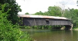
The Hillsgrove Covered Bridge is a Burr arch truss
covered bridge
over Loyalsock Creek
in Hillsgrove Township
, Sullivan County
in the U.S. state
of Pennsylvania
. It was built circa 1850 and is 186 feet (56.7 m) long. In 1973, it became the first covered bridge in the county to be placed on the National Register of Historic Places (NRHP). The bridge is named for the township and nearby unincorporated
village
of Hillsgrove, and is also known as Rinkers Covered Bridge for an adjoining farm.
Pennsylvania had the first covered bridge in the United States, and has had the most such bridges since the 19th century. They were a transition between stone and metal bridges, with the roof and sides protecting the wooden structure from the weather. The Hillsgrove bridge has load-bearing
Burr arch
es sandwiching multiple vertical king posts on each side, for strength and rigidity. It was built by Sadler Rodgers, who also constructed the nearby Forksville Covered Bridge
in the same year, with a similar design.
The Hillsgrove bridge is the longest of three covered bridges remaining in Sullivan County, and served as a landing site for lumber rafts on the creek between 1870 and 1890. Nineteenth-century regulations restricting speed, number of animals, and fire are still posted on the bridge. Restoration work was carried out in 1963, 1968 and 2001, and the bridge is still in use, with average daily traffic of 54 vehicles in 2006. Despite these restorations, as of 2006 the National Bridge Inventory
found it to be "Functionally Obsolete", with problematic foundations and railings, and a 16.5 percent structural sufficiency rating.
via Splash Dam
Road (TR 359). The bridge crosses Loyalsock Creek northeast and upstream of the unincorporated village of Hillsgrove, and is just south of Elkland Township
. Its official name on the NRHP is Hillsgrove Covered Bridge. It is also known as Rinkers Covered Bridge for the Rinker farm, which is located at the east end of the bridge. Sullivan County is located in north central Pennsylvania, about 123 miles (197.9 km) northwest of Philadelphia
and 195 miles (313.8 km) east-northeast of Pittsburgh
.
The village of Hillsgrove is where Daniel Ogden became the first settler in what is now Sullivan County, circa 1786. John Hill, who founded and named the village of Hill's Grove (later just Hillsgrove), came to the area in 1789 and bought Ogden's land about 1794. Sullivan County was formed from part of Lycoming County
on March 14, 1847, and the bridge was built in 1850. The division of Lycoming County ran through Plunketts Creek Township
, so there were initially townships of this name in each of the adjoining counties. To avoid confusion, the name of the Sullivan County township was changed to Hillsgrove Township in 1856; the new township name was taken from the village of Hillsgrove, which was (and is) its largest settlement. Hillsgrove Covered Bridge is named for its township and the nearby village, and gave its name to a nearby one-room school
known as the Bridge View School.
The name Hillsgrove Covered Bridge can also refer to a now vanished covered bridge, also over Loyalsock Creek, but in the village of Hillsgrove. This stood from 1876 until 1934, when it was condemned and replaced by a steel and concrete structure. It was the third covered bridge on the site: the first fell into the creek, and the second was torn down to make way for the third bridge.
in Philadelphia, Pennsylvania. According to Susan M. Zacher, author of The Covered Bridges of Pennsylvania: A Guide, the first covered bridges of the Burr arch truss design were also built in the state. Pennsylvania is estimated to have once had at least 1,500 covered bridges and is believed to have had the most in the country between 1830 and 1875. In 2001, Pennsylvania had more surviving historic covered bridges than any other state; 221 remained in 40 of its 67 counties.
Covered bridges were a transition between stone and metal bridges, the latter made of cast-iron or steel. In 19th-century Pennsylvania, lumber was an abundant resource for bridge construction, but did not last long when exposed to the elements. The roof and enclosed sides of covered bridges protected the structural elements, allowing some of these bridges to survive for well over a century. A Burr arch truss consists of a load-bearing
arch
sandwiching multiple king posts, resulting in stronger and more rigid structure than one made of either element alone. Although there were 30 covered bridges in Sullivan County in 1890, only five were left by 1954, and as of 2008 only three remain: Forksville
, Hillsgrove, and Sonestown
.
 All three Sullivan County covered bridges were built in or circa 1850 with Burr arch trusses. The Hillsgrove bridge was built for Sullivan County by Sadler Rogers
(or Rodgers), a native of Forksville who was only 18 years old at the time. He built the Forksville bridge the same year. The Forksville and Hillsgrove bridges both cross Loyalsock Creek, with the latter about 5 miles (8 km) further downstream. Although most sources do not list the builder of the Sonestown bridge, a 1997 newspaper article on the remaining Sullivan County covered bridges reported that Rodgers had designed it also.
 On July 2, 1973, the Hillsgrove bridge was the first covered bridge in Sullivan County to be added to the NRHP, and on July 24, 1980 it was again included on the NRHP in a Multiple Property Submission of seven Covered Bridges of Bradford, Sullivan and Lycoming Counties
. The Hillsgrove bridge is on the 2006 National Bridge Inventory (NBI), which lists the covered bridge as 186 feet (56.7 m) long, with a roadway 12 in 2 in (3.71 m) wide, and a maximum load of 5 short tons (4.5 MT). However, the maximum load posted on the bridge itself is only 3 short tons (2.7 MT). According to the NRHP, the bridge's "road surface width" is 18 feet (5.5 m), which is only sufficient for a single lane of traffic.
As of 2008, each portal has a sign with the posted clearance height of 8 feet (2.4 m), and the west portal also has a "No Trucks Allowed" sign hanging below this. A sign posted on the east portal above the clearance preserves the following 19th-century limits on its use: "Notice: All persons are forbidden to ride drive or lead any animal over this bridge faster than a walk or to drive more than 15 head of cattle horses or mules thereon at one time or to carry fire thereon except in a safe vessel under a penalty of not less than $.30 for each offence."
The covered bridge rests on abutment
s of stone and mortar, which have been reinforced with concrete. There are no parapets. The bridge deck is made of crosswise "narrow width laid flooring". Wheel guards on the deck separate the roadway from the pedestrian walkways on either side and protect the sides, which are covered with "vertical board and batten siding" almost to the eaves
. As of 2008, the sides are unpainted, but the portals are painted red. The bridge has long, narrow windows with wooden shutters: the south side has three windows, and the north side has two. An opening between the eaves and the siding runs the length of the bridge on both sides. The gable roof is sheet metal
which has been installed over the original wooden shake shingles
. The bridge is supported by a Burr arch truss, and is similar in design and construction to the one in Forksville. The western end of the Hillsgrove bridge lies against a steep hillside, and those approaching the bridge from the west must make a sharp right turn to enter it.
Attitudes towards covered bridges in Sullivan County changed considerably in the last half of the 20th century. Two of the five bridges that remained in 1954 were razed by 1970, when the Pennsylvania Department of Transportation
considered tearing down the Forksville bridge (but renovated it because of its historic nature and appeal to tourists). The Hillsgrove Covered Bridge was added to the NRHP in 1973 and the two other bridges were added in 1980. The Pennsylvania Historical and Museum Commission
now forbids the destruction of any covered bridge on the NRHP in the state and has to approve any renovation work.
 In the 19th century the Hillsgrove Covered Bridge survived major floods on March 1, 1865, and June 1, 1889, that destroyed other bridges in the West Branch Susquehanna River valley. Between about 1870 and 1890, logging in the Loyalsock Creek watershed produced lumber rafts that floated beneath the bridge. The bridge was the site of "Uncle Ben's Landing" for lumber rafts, which did not travel at night. These rafts, each containing 5,000–30,000 board feet
(11.8–70.8 m³) of lumber, were carried down the Loyalsock to its mouth at Montoursville
. The raft era ended when the eastern hemlock
were all clearcut
.
An April, 1963 article on covered bridges in Sullivan and Lycoming counties noted that the Hillsgrove Bridge's deck was "a bit swaybacked", and according to the NBI data, the bridge was "reconstructed" in 1963. T. Corbin Lewis, a retired electrical contractor
from Hillsgrove Township, restored the bridge in 1968. The concrete reinforcement on the southwest abutment of the Hillsgrove bridge is dated 1968, but the other work done in this restoration is not documented. Lewis also restored the Forksville Covered Bridge in 1970, with what its NRHP nomination form describes as "all kinds of odd repairs". Lewis' restoration work at Forksville involved cutting windows into the sides of the bridge for the first time, with four windows on the south side and three on the north. While the Hillsgrove bridge does have more windows on the south side (three) than the north (two), it is not known if they are original or were added later.
Covered Bridge Road north of Loyalsock Creek is accessed only by the Hillsgrove Covered Bridge at the eastern end, and a bridge over Elk Creek at the western end. Sullivan County replaced the bridge over Elk Creek between March 21 and July 21, 1989. Without the Elk Creek bridge, access for five families, a business, and a Little League Baseball camp with 110 children was limited to the covered bridge. County officials noted that despite the covered bridge's posted weight limit of 2 short tons (1.8 MT), it could still support 5 short tons (4.5 MT), sufficient for small fire trucks and ambulances. In an emergency, larger emergency vehicles could ford
the creek if needed. In any case, the limited access did not cause any problems for the four-month period while the Elk Creek bridge was replaced.
The Evans' book describes repairs to the siding on the northeast of the bridge, done between 1991 and 2000. In 2001, the US Department of Transportation Federal Highway Administration
awarded $360,000 for 80 percent of the restoration costs of the Hillsgrove bridge under the Historic Covered Bridge Preservation Program. It was one of two bridges in Pennsylvania and 43 nationwide selected for the program that year.
Despite the restorations and repairs, the 2006 Federal Highway Administration
National Bridge Inventory
found the bridge to be "Functionally Obsolete". In addition, the sufficiency rating of the bridge structure was 16.5 percent, the foundations were "unstable for calculated scour
conditions ", and the railing did not meet "currently acceptable standards". Its overall condition was deemed "basically intolerable requiring high priority of corrective action", and the estimated cost to improve the bridge was $108,000. The bridge is still used, and its average daily traffic was 54 vehicles in 2006. According to Zacher, the "Sullivan County bridges, because of their settings, are some of the most attractive in the state".
The bridge was struck by a house when Loyalsock Creek flooded from over 12 inches (30.5 cm) of rainfall caused by Tropical Storm Lee
on September 7, 2011. While still standing, the superstructure is damaged beyond reasonable repair, and is in danger of falling.
 The following table is a comparison of published measurements of length, width and load recorded in different sources using different methods, as well as the name or names cited. The NBI measures bridge length between the "backwalls of abutments" or pavement grooves and the roadway width as "the most restrictive minimum distance between curbs or rails". The NRHP form was prepared by the Pennsylvania Historical and Museum Commission
(PHMC), which surveyed county engineers, historical and covered bridge societies, and others for all the covered bridges in the commonwealth. The Evans visited every covered bridge in Pennsylvania in 2001 and measured each bridge's length (portal to portal) and width (at the portal) for their book. The data in Zacher's book was based on a 1991 survey of all covered bridges in Pennsylvania by the PHMC and the Pennsylvania Department of Transportation, aided by local government and private agencies. The article uses primarily the NBI and NRHP data, as they are national programs.

Burr Truss
The Burr Arch Truss — or simply Burr Truss or Burr Arch — is a combination of an arch and a multiple kingpost truss design. It was invented in 1804 by Theodore Burr, patented on April 3, 1817, and used in bridges, usually covered bridges....
covered bridge
Covered bridge
A covered bridge is a bridge with enclosed sides and a roof, often accommodating only a single lane of traffic. Most covered bridges are wooden; some newer ones are concrete or metal with glass sides...
over Loyalsock Creek
Loyalsock Creek
Loyalsock Creek is a tributary of the West Branch Susquehanna River located chiefly in Sullivan and Lycoming counties in Pennsylvania in the United States...
in Hillsgrove Township
Hillsgrove Township, Pennsylvania
Hillsgrove Township is a township in Sullivan County, Pennsylvania, United States. The population was 265 at the 2000 census.-Geography:According to the United States Census Bureau, the township has a total area of , of which, of it is land and 0.04% is water.Hillsgrove Township is bordered by Fox...
, Sullivan County
Sullivan County, Pennsylvania
Sullivan County is a county located in the U.S. state of Pennsylvania. As of 2010, the population is 6,428. Sullivan County was created on March 15, 1847, from part of Lycoming County and named for Charles Sullivan, leader of the Pennsylvania Senate...
in the U.S. state
U.S. state
A U.S. state is any one of the 50 federated states of the United States of America that share sovereignty with the federal government. Because of this shared sovereignty, an American is a citizen both of the federal entity and of his or her state of domicile. Four states use the official title of...
of Pennsylvania
Pennsylvania
The Commonwealth of Pennsylvania is a U.S. state that is located in the Northeastern and Mid-Atlantic regions of the United States. The state borders Delaware and Maryland to the south, West Virginia to the southwest, Ohio to the west, New York and Ontario, Canada, to the north, and New Jersey to...
. It was built circa 1850 and is 186 feet (56.7 m) long. In 1973, it became the first covered bridge in the county to be placed on the National Register of Historic Places (NRHP). The bridge is named for the township and nearby unincorporated
Unincorporated area
In law, an unincorporated area is a region of land that is not a part of any municipality.To "incorporate" in this context means to form a municipal corporation, a city, town, or village with its own government. An unincorporated community is usually not subject to or taxed by a municipal government...
village
Village
A village is a clustered human settlement or community, larger than a hamlet with the population ranging from a few hundred to a few thousand , Though often located in rural areas, the term urban village is also applied to certain urban neighbourhoods, such as the West Village in Manhattan, New...
of Hillsgrove, and is also known as Rinkers Covered Bridge for an adjoining farm.
Pennsylvania had the first covered bridge in the United States, and has had the most such bridges since the 19th century. They were a transition between stone and metal bridges, with the roof and sides protecting the wooden structure from the weather. The Hillsgrove bridge has load-bearing
Structural engineering
Structural engineering is a field of engineering dealing with the analysis and design of structures that support or resist loads. Structural engineering is usually considered a specialty within civil engineering, but it can also be studied in its own right....
Burr arch
Arch
An arch is a structure that spans a space and supports a load. Arches appeared as early as the 2nd millennium BC in Mesopotamian brick architecture and their systematic use started with the Ancient Romans who were the first to apply the technique to a wide range of structures.-Technical aspects:The...
es sandwiching multiple vertical king posts on each side, for strength and rigidity. It was built by Sadler Rodgers, who also constructed the nearby Forksville Covered Bridge
Forksville Covered Bridge
The Forksville Covered Bridge is a Burr arch truss covered bridge over Loyalsock Creek in the borough of Forksville, Sullivan County, in the U.S. state of Pennsylvania. It was built in 1850 and is in length. The bridge was placed on the National Register of Historic Places in 1980...
in the same year, with a similar design.
The Hillsgrove bridge is the longest of three covered bridges remaining in Sullivan County, and served as a landing site for lumber rafts on the creek between 1870 and 1890. Nineteenth-century regulations restricting speed, number of animals, and fire are still posted on the bridge. Restoration work was carried out in 1963, 1968 and 2001, and the bridge is still in use, with average daily traffic of 54 vehicles in 2006. Despite these restorations, as of 2006 the National Bridge Inventory
National Bridge Inventory
The National Bridge Inventory is a database, compiled by the Federal Highway Administration, with information on all bridges and tunnels in the United States that have roads passing above or below. This is similar to the grade crossing identifier number database compiled by the Federal Railroad...
found it to be "Functionally Obsolete", with problematic foundations and railings, and a 16.5 percent structural sufficiency rating.
Overview
The covered bridge is in Hillsgrove Township on Covered Bridge Road (Township Road 357), which is 0.1 mile (0.160934 km) north of Pennsylvania Route 87Pennsylvania Route 87
Pennsylvania Route 87 is a long north–south state highway located in northern Pennsylvania. The southern terminus of the route is at exit 21 of Interstate 180 and U.S. Route 220 in Montoursville. The northern terminus is at U.S. Route 6 in Washington Township.The road is called Loyalsock...
via Splash Dam
Splash dam
A splash dam was a temporary wooden dam used to raise the water level in streams to float logs downstream to sawmills. By impounding water and allowing it to be released on the log drive's schedule, these dams allowed many more logs to be brought to market than the natural flow of the creek allowed...
Road (TR 359). The bridge crosses Loyalsock Creek northeast and upstream of the unincorporated village of Hillsgrove, and is just south of Elkland Township
Elkland Township, Pennsylvania
Elkland Township is a township in Sullivan County, Pennsylvania, United States. The population was 607 at the 2000 census.-Geography:According to the United States Census Bureau, the township has a total area of , of which, of it is land and of it is water.Elkland Township is bordered by...
. Its official name on the NRHP is Hillsgrove Covered Bridge. It is also known as Rinkers Covered Bridge for the Rinker farm, which is located at the east end of the bridge. Sullivan County is located in north central Pennsylvania, about 123 miles (197.9 km) northwest of Philadelphia
Philadelphia, Pennsylvania
Philadelphia is the largest city in the Commonwealth of Pennsylvania and the county seat of Philadelphia County, with which it is coterminous. The city is located in the Northeastern United States along the Delaware and Schuylkill rivers. It is the fifth-most-populous city in the United States,...
and 195 miles (313.8 km) east-northeast of Pittsburgh
Pittsburgh, Pennsylvania
Pittsburgh is the second-largest city in the US Commonwealth of Pennsylvania and the county seat of Allegheny County. Regionally, it anchors the largest urban area of Appalachia and the Ohio River Valley, and nationally, it is the 22nd-largest urban area in the United States...
.
The village of Hillsgrove is where Daniel Ogden became the first settler in what is now Sullivan County, circa 1786. John Hill, who founded and named the village of Hill's Grove (later just Hillsgrove), came to the area in 1789 and bought Ogden's land about 1794. Sullivan County was formed from part of Lycoming County
Lycoming County, Pennsylvania
-Appalachian Mountains and Allegheny Plateau:Lycoming County is divided between the Appalachian Mountains in the south, the dissected Allegheny Plateau in the north and east, and the valley of the West Branch Susquehanna River between these.-West Branch Susquehanna River:The West Branch of the...
on March 14, 1847, and the bridge was built in 1850. The division of Lycoming County ran through Plunketts Creek Township
Plunketts Creek Township, Pennsylvania
Plunketts Creek Township is a township in Lycoming County, Pennsylvania, in the United States. It includes the villages of Barbours and Proctor. The population was 771 at the 2000 census...
, so there were initially townships of this name in each of the adjoining counties. To avoid confusion, the name of the Sullivan County township was changed to Hillsgrove Township in 1856; the new township name was taken from the village of Hillsgrove, which was (and is) its largest settlement. Hillsgrove Covered Bridge is named for its township and the nearby village, and gave its name to a nearby one-room school
One-room school
One-room schools were commonplace throughout rural portions of various countries including the United States, Canada, Australia, New Zealand, United Kingdom, Ireland and Spain in the late 19th and early 20th centuries. In most rural and small town schools, all of the students met in a single room...
known as the Bridge View School.
The name Hillsgrove Covered Bridge can also refer to a now vanished covered bridge, also over Loyalsock Creek, but in the village of Hillsgrove. This stood from 1876 until 1934, when it was condemned and replaced by a steel and concrete structure. It was the third covered bridge on the site: the first fell into the creek, and the second was torn down to make way for the third bridge.
Background
The first covered bridge in the United States was built in 1800 over the Schuylkill RiverSchuylkill River
The Schuylkill River is a river in Pennsylvania. It is a designated Pennsylvania Scenic River.The river is about long. Its watershed of about lies entirely within the state of Pennsylvania. The source of its eastern branch is in the Appalachian Mountains at Tuscarora Springs, near Tamaqua in...
in Philadelphia, Pennsylvania. According to Susan M. Zacher, author of The Covered Bridges of Pennsylvania: A Guide, the first covered bridges of the Burr arch truss design were also built in the state. Pennsylvania is estimated to have once had at least 1,500 covered bridges and is believed to have had the most in the country between 1830 and 1875. In 2001, Pennsylvania had more surviving historic covered bridges than any other state; 221 remained in 40 of its 67 counties.
Covered bridges were a transition between stone and metal bridges, the latter made of cast-iron or steel. In 19th-century Pennsylvania, lumber was an abundant resource for bridge construction, but did not last long when exposed to the elements. The roof and enclosed sides of covered bridges protected the structural elements, allowing some of these bridges to survive for well over a century. A Burr arch truss consists of a load-bearing
Structural engineering
Structural engineering is a field of engineering dealing with the analysis and design of structures that support or resist loads. Structural engineering is usually considered a specialty within civil engineering, but it can also be studied in its own right....
arch
Arch
An arch is a structure that spans a space and supports a load. Arches appeared as early as the 2nd millennium BC in Mesopotamian brick architecture and their systematic use started with the Ancient Romans who were the first to apply the technique to a wide range of structures.-Technical aspects:The...
sandwiching multiple king posts, resulting in stronger and more rigid structure than one made of either element alone. Although there were 30 covered bridges in Sullivan County in 1890, only five were left by 1954, and as of 2008 only three remain: Forksville
Forksville Covered Bridge
The Forksville Covered Bridge is a Burr arch truss covered bridge over Loyalsock Creek in the borough of Forksville, Sullivan County, in the U.S. state of Pennsylvania. It was built in 1850 and is in length. The bridge was placed on the National Register of Historic Places in 1980...
, Hillsgrove, and Sonestown
Sonestown Covered Bridge
The Sonestown Covered Bridge is a Burr arch truss covered bridge over Muncy Creek in Davidson Township, Sullivan County, in the U.S. state of Pennsylvania. Built circa 1850, the bridge is long, and was placed on the National Register of Historic Places in 1980...
.
Construction and description
Sadler Rogers
Sadler Rogers , , was an American builder and farmer. Sadler Rodgers built several bridges which are now considered part of the historic heritage of Pennsylvania, including the Forksville Covered Bridge.-References:...
(or Rodgers), a native of Forksville who was only 18 years old at the time. He built the Forksville bridge the same year. The Forksville and Hillsgrove bridges both cross Loyalsock Creek, with the latter about 5 miles (8 km) further downstream. Although most sources do not list the builder of the Sonestown bridge, a 1997 newspaper article on the remaining Sullivan County covered bridges reported that Rodgers had designed it also.
Covered Bridges of Bradford, Sullivan and Lycoming Counties
The Covered Bridges of Bradford, Sullivan and Lycoming Counties are seven covered bridges in northcentral Pennsylvania in the United States, which were included on the National Register of Historic Places in a Thematic Resources submission on July 24, 1980. One of the bridges is in Bradford...
. The Hillsgrove bridge is on the 2006 National Bridge Inventory (NBI), which lists the covered bridge as 186 feet (56.7 m) long, with a roadway 12 in 2 in (3.71 m) wide, and a maximum load of 5 short tons (4.5 MT). However, the maximum load posted on the bridge itself is only 3 short tons (2.7 MT). According to the NRHP, the bridge's "road surface width" is 18 feet (5.5 m), which is only sufficient for a single lane of traffic.
As of 2008, each portal has a sign with the posted clearance height of 8 feet (2.4 m), and the west portal also has a "No Trucks Allowed" sign hanging below this. A sign posted on the east portal above the clearance preserves the following 19th-century limits on its use: "Notice: All persons are forbidden to ride drive or lead any animal over this bridge faster than a walk or to drive more than 15 head of cattle horses or mules thereon at one time or to carry fire thereon except in a safe vessel under a penalty of not less than $.30 for each offence."
The covered bridge rests on abutment
Abutment
An abutment is, generally, the point where two structures or objects meet. This word comes from the verb abut, which means adjoin or having common boundary. An abutment is an engineering term that describes a structure located at the ends of a bridge, where the bridge slab adjoins the approaching...
s of stone and mortar, which have been reinforced with concrete. There are no parapets. The bridge deck is made of crosswise "narrow width laid flooring". Wheel guards on the deck separate the roadway from the pedestrian walkways on either side and protect the sides, which are covered with "vertical board and batten siding" almost to the eaves
Eaves
The eaves of a roof are its lower edges. They usually project beyond the walls of the building to carry rain water away.-Etymology:"Eaves" is derived from Old English and is both the singular and plural form of the word.- Function :...
. As of 2008, the sides are unpainted, but the portals are painted red. The bridge has long, narrow windows with wooden shutters: the south side has three windows, and the north side has two. An opening between the eaves and the siding runs the length of the bridge on both sides. The gable roof is sheet metal
Sheet metal
Sheet metal is simply metal formed into thin and flat pieces. It is one of the fundamental forms used in metalworking, and can be cut and bent into a variety of different shapes. Countless everyday objects are constructed of the material...
which has been installed over the original wooden shake shingles
Shake (shingle)
A shake is a basic wooden shingle that is made from split logs. Shakes have traditionally been used for roofing and siding applications around the world. Higher grade shakes are typically used for roofing purposes, while the lower grades are used for siding purposes...
. The bridge is supported by a Burr arch truss, and is similar in design and construction to the one in Forksville. The western end of the Hillsgrove bridge lies against a steep hillside, and those approaching the bridge from the west must make a sharp right turn to enter it.
Attitudes towards covered bridges in Sullivan County changed considerably in the last half of the 20th century. Two of the five bridges that remained in 1954 were razed by 1970, when the Pennsylvania Department of Transportation
Pennsylvania Department of Transportation
The Pennsylvania Department of Transportation oversees transportation issues in the Commonwealth of Pennsylvania. The administrator of PennDOT is the Pennsylvania Secretary of Transportation, currently Barry Schoch Presently, PennDOT supports over of state roads and highways, about 25,000...
considered tearing down the Forksville bridge (but renovated it because of its historic nature and appeal to tourists). The Hillsgrove Covered Bridge was added to the NRHP in 1973 and the two other bridges were added in 1980. The Pennsylvania Historical and Museum Commission
Pennsylvania Historical and Museum Commission
The Pennsylvania Historical and Museum Commission is the governmental agency of the Commonwealth of Pennsylvania responsible for the collection, conservation and interpretation of Pennsylvania's historic heritage...
now forbids the destruction of any covered bridge on the NRHP in the state and has to approve any renovation work.
Use and restoration
Board foot
The board-foot is a specialized unit of measure for the volume of lumber in the United States and Canada. It is the volume of a one-foot length of a board one foot wide and one inch thick....
(11.8–70.8 m³) of lumber, were carried down the Loyalsock to its mouth at Montoursville
Montoursville, Pennsylvania
Montoursville is a borough in Lycoming County, Pennsylvania, in the United States. As of the 2000 census, the borough population was 4,777. It is part of the Williamsport, Pennsylvania Metropolitan Statistical Area. It was named for Madame Montour, a Native American leader and skilled interpreter...
. The raft era ended when the eastern hemlock
Eastern Hemlock
Tsuga canadensis, also known as eastern or Canadian hemlock, and in the French-speaking regions of Canada as pruche du Canada, is a coniferous tree native to eastern North America. It ranges from northeastern Minnesota eastward through southern Quebec to Nova Scotia, and south in the Appalachian...
were all clearcut
Clearcutting
Clearcutting, or clearfelling, is a controversial forestry/logging practice in which most or all trees in an area are uniformly cut down. Clearcutting, along with shelterwood and seed tree harvests, is used by foresters to create certain types of forest ecosystems and to promote select species that...
.
An April, 1963 article on covered bridges in Sullivan and Lycoming counties noted that the Hillsgrove Bridge's deck was "a bit swaybacked", and according to the NBI data, the bridge was "reconstructed" in 1963. T. Corbin Lewis, a retired electrical contractor
General contractor
A general contractor is responsible for the day-to-day oversight of a construction site, management of vendors and trades, and communication of information to involved parties throughout the course of a building project.-Description:...
from Hillsgrove Township, restored the bridge in 1968. The concrete reinforcement on the southwest abutment of the Hillsgrove bridge is dated 1968, but the other work done in this restoration is not documented. Lewis also restored the Forksville Covered Bridge in 1970, with what its NRHP nomination form describes as "all kinds of odd repairs". Lewis' restoration work at Forksville involved cutting windows into the sides of the bridge for the first time, with four windows on the south side and three on the north. While the Hillsgrove bridge does have more windows on the south side (three) than the north (two), it is not known if they are original or were added later.
Covered Bridge Road north of Loyalsock Creek is accessed only by the Hillsgrove Covered Bridge at the eastern end, and a bridge over Elk Creek at the western end. Sullivan County replaced the bridge over Elk Creek between March 21 and July 21, 1989. Without the Elk Creek bridge, access for five families, a business, and a Little League Baseball camp with 110 children was limited to the covered bridge. County officials noted that despite the covered bridge's posted weight limit of 2 short tons (1.8 MT), it could still support 5 short tons (4.5 MT), sufficient for small fire trucks and ambulances. In an emergency, larger emergency vehicles could ford
Ford (crossing)
A ford is a shallow place with good footing where a river or stream may be crossed by wading or in a vehicle. A ford is mostly a natural phenomenon, in contrast to a low water crossing, which is an artificial bridge that allows crossing a river or stream when water is low.The names of many towns...
the creek if needed. In any case, the limited access did not cause any problems for the four-month period while the Elk Creek bridge was replaced.
The Evans' book describes repairs to the siding on the northeast of the bridge, done between 1991 and 2000. In 2001, the US Department of Transportation Federal Highway Administration
Federal Highway Administration
The Federal Highway Administration is a division of the United States Department of Transportation that specializes in highway transportation. The agency's major activities are grouped into two "programs," the Federal-aid Highway Program and the Federal Lands Highway Program...
awarded $360,000 for 80 percent of the restoration costs of the Hillsgrove bridge under the Historic Covered Bridge Preservation Program. It was one of two bridges in Pennsylvania and 43 nationwide selected for the program that year.
Despite the restorations and repairs, the 2006 Federal Highway Administration
Federal Highway Administration
The Federal Highway Administration is a division of the United States Department of Transportation that specializes in highway transportation. The agency's major activities are grouped into two "programs," the Federal-aid Highway Program and the Federal Lands Highway Program...
National Bridge Inventory
National Bridge Inventory
The National Bridge Inventory is a database, compiled by the Federal Highway Administration, with information on all bridges and tunnels in the United States that have roads passing above or below. This is similar to the grade crossing identifier number database compiled by the Federal Railroad...
found the bridge to be "Functionally Obsolete". In addition, the sufficiency rating of the bridge structure was 16.5 percent, the foundations were "unstable for calculated scour
Bridge scour
Bridge scour is the removal of sediment such as sand and rocks from around bridge abutments or piers. Scour, caused by swiftly moving water, can scoop out scour holes, compromising the integrity of a structure....
conditions ", and the railing did not meet "currently acceptable standards". Its overall condition was deemed "basically intolerable requiring high priority of corrective action", and the estimated cost to improve the bridge was $108,000. The bridge is still used, and its average daily traffic was 54 vehicles in 2006. According to Zacher, the "Sullivan County bridges, because of their settings, are some of the most attractive in the state".
The bridge was struck by a house when Loyalsock Creek flooded from over 12 inches (30.5 cm) of rainfall caused by Tropical Storm Lee
Tropical Storm Lee (2011)
Tropical Storm Lee was the twelfth named storm and thirteenth system overall of the 2011 Atlantic hurricane season, developing from a broad tropical disturbance over the Gulf on September 1. It was designated as Tropical Storm Lee the next day...
on September 7, 2011. While still standing, the superstructure is damaged beyond reasonable repair, and is in danger of falling.
Bridge dimensions
Pennsylvania Historical and Museum Commission
The Pennsylvania Historical and Museum Commission is the governmental agency of the Commonwealth of Pennsylvania responsible for the collection, conservation and interpretation of Pennsylvania's historic heritage...
(PHMC), which surveyed county engineers, historical and covered bridge societies, and others for all the covered bridges in the commonwealth. The Evans visited every covered bridge in Pennsylvania in 2001 and measured each bridge's length (portal to portal) and width (at the portal) for their book. The data in Zacher's book was based on a 1991 survey of all covered bridges in Pennsylvania by the PHMC and the Pennsylvania Department of Transportation, aided by local government and private agencies. The article uses primarily the NBI and NRHP data, as they are national programs.
| Source | Year | Length feet (m) |
Width feet (m) |
Load short tons (MT) |
Name used |
|---|---|---|---|---|---|
| NBI | 2006 | 186 feet (56.7 m) | 12 in 2 in (3.71 m) | 5 short tons (4.5 MT) | Hillsgrove |
| NRHP | 1980 | 171 feet (52.1 m) | 18 feet (5.5 m) | 3 short tons (2.7 MT) | Hillsgrove |
| Evans | 2001 | 185 in 8 in (56.59 m) | 15 feet (4.6 m) | NA | Hillsgrove, Rinkers |
| Zacher | 1994 | 152 feet (46.3 m) | 18 feet (5.5 m) | NA | Hillsgrove |
See also