
Hammocks Beach State Park
Encyclopedia
Hammocks Beach State Park is a North Carolina state park in Onslow County
, North Carolina
in the United States
. Located near Swansboro
, along the Southern Outer Banks
, or Crystal Coast
, the state park covers 1145 acres (4.6 km²) and consists mainly of Bear Island, but also nearby Huggins Island, as well as Jones Island in the mouth of the White Oak River
.
A ferry service runs from the Hammocks Beach State Park headquarters on the mainland to Bear Island via Cow Channel. While the ride, which some 200,000 people a year take, is only 15 minutes long, it is narrow and winding. The channel has increasingly become more difficult to navigate at low tide since 1996 due to sand migration in the estuary and a series of hurricanes. Shoaling in the channel has been constant since ferry operations began in the early 1960s, and has worsened in recent years due to hurricane activity, particularly in the half-mile stretch of the channel nearest the island. During low tides, the park has used 11-passenger skiffs to ferry passengers rather than its 40 feet (12.2 m), 28-passenger boats. The ferry service was temporarily curtailed in 2002 because at low tide, the water was "extremely low" in a 200 feet (61 m) section of the channel. It was shut down completely for several months in early 2007 for an emergency dredging project in the channel route to the island. As of 2009 Hammocks Beach State Park now offers a ferry that can hold up to 49 passengers.
 Nearby Huggins Island, which sits just inland from Bear Island between it and the mainland, largely consists of a 110 acre (0.4451546 km²) thick maritime forest with many large live oak trees. The island is mostly flat with no sand dunes, and is about a quarter of the size of Bear Island. At the western end of the island, from which the town of Swansboro can be seen, is a large marsh. Huggins Island is only accessible by private boat, and there are no facilities, and camping is not permitted on this island.
An even smaller island near Huggins is known in the area for its collection of sharks teeth, which wash in with the tide on the eastern tip, giving it the name Sharks Tooth Island, but it is not part of Hammocks Beach State Park. Huggins Island became a part of Hammocks Beach State Park in 2000.
and live oak
trees are prominent on the property and Eastern Painted Bunting
have been seen nesting on the island. Breeding populations of this sparrow-sized member of the finch family are rare in North Carolina. In October 2007, 17 acre (0.06879662 km²) of the island permanently became part of Hammocks Beach State Park. The island, which is considered a regionally significant natural heritage area, was zoned for residential development and will now be protected for years to come.
Due to its location, Bear Island and Huggins Island have often played a role in the protection of the mainland. During the Civil War, Confederate troops on Bear Island defended it against Union forces occupying Bogue Banks
. The island again assumed military importance nearly a century later when, during World War II, the Coast Guard used it to secure the coast and monitor German U-boat activity. Huggins Island also featured in the Civil War. Confederate Brigadier General Walter Gwynn
, in charge of coastal defenses from New Bern to the South Carolina
line, working with North Carolina Adjutant General Richard Gatlin, proposed to erect a six-gun battery on Huggins Island to protect Bogue Inlet. Construction of the fort was completed in December 1861 with labor supplied by local slaves working alongside the troops detailed for that purpose. Captain Daniel Munn's company was then stationed at the fort to man the cannons for one year. They were then ordered to join General Lawrence Branch's Brigade at New Bern, and took the cannons with them as they marched out of Swansboro. Several of the cannons were captured by Union troops during the Battle of New Bern
on March 14, 1862. On August 19, a Union force commanded by Colonel Thomas G. Stevenson
of the 24th Massachusetts Volunteer Infantry made a reconnaissance to Swansboro. During the expedition the fort at Huggins’ Island was burned, the barracks and ammunition magazine collapsing into ashes. Only the earthen embankment remains as evidence of the fort's existence. Those earthworks, however, have dodged development and erosion, and are now the only unspoiled example of Confederate earthwork fortifications surviving on the North Carolina coast.
Early in the 20th century, Dr. William Sharpe, a neurosurgeon of New York, came to Bear Island to hunt. His love of the island prompted him to acquire it for his retirement. Sharpe intended to will the property to John Hurst, his longtime hunting guide and friend, but Hurst persuaded him to donate it to the North Carolina Teachers Association, an organization of African American teachers. In 1950, the group assumed the deed to Bear Island and attempted to develop the property. Limited funds and the island's remoteness rendered their efforts unsuccessful. In 1961, the association donated the island to the state of North Carolina for a park. Initially planned as a park for minorities, Hammocks Beach State Park opened for all people following the Civil Rights Act of 1964.
Onslow County, North Carolina
-Demographics:As of the census of 2000, there were 150,355 people, 48,122 households, and 36,572 families residing in the county. The population density was 196 people per square mile . There were 55,726 housing units at an average density of 73 per square mile...
, North Carolina
North Carolina
North Carolina is a state located in the southeastern United States. The state borders South Carolina and Georgia to the south, Tennessee to the west and Virginia to the north. North Carolina contains 100 counties. Its capital is Raleigh, and its largest city is Charlotte...
in the United States
United States
The United States of America is a federal constitutional republic comprising fifty states and a federal district...
. Located near Swansboro
Swansboro, North Carolina
Swansboro is a town in Onslow County, North Carolina, United States. In 2007, the estimated population was 1,540. It is part of the Jacksonville, North Carolina Metropolitan Statistical Area...
, along the Southern Outer Banks
Outer Banks
The Outer Banks is a 200-mile long string of narrow barrier islands off the coast of North Carolina, beginning in the southeastern corner of Virginia Beach on the east coast of the United States....
, or Crystal Coast
Crystal Coast
The Crystal Coast is an 85-mile stretch of coastline in North Carolina that extends from the Cape Lookout National Seashore, which includes 56 miles of protected beaches, westward to the New River. It is also known as the Southern Outer Banks and is a popular area with tourists and second-home...
, the state park covers 1145 acres (4.6 km²) and consists mainly of Bear Island, but also nearby Huggins Island, as well as Jones Island in the mouth of the White Oak River
White Oak River
The White Oak River is a blackwater river, approximately 40 mi long, on the coastal plain of southeast North Carolina in the United States. It empties in the Atlantic Ocean.-Course:...
.
Bear Island
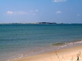
Bear Island, which is four mile long and has a south-facing beach, is characterized by an extensive dune system, a pocket of maritime forest, and a shrub thicket and marsh on the north, or sound side of the island. It is popular with daytrippers, boaters, kayakers and campers. While it serves a recreational function, with a new bath house and primitive camping sites, the vast majority of the island is wild and undisturbed. Most of the animals on Bear Island flew or swam through tidal creeks and marshes to make their home on the island. Fresh water is scarce and only found in a few ponds in the forest between some dunes. Recent hurricanes have had a considerable impact on the oceanfront beach/dune system.A ferry service runs from the Hammocks Beach State Park headquarters on the mainland to Bear Island via Cow Channel. While the ride, which some 200,000 people a year take, is only 15 minutes long, it is narrow and winding. The channel has increasingly become more difficult to navigate at low tide since 1996 due to sand migration in the estuary and a series of hurricanes. Shoaling in the channel has been constant since ferry operations began in the early 1960s, and has worsened in recent years due to hurricane activity, particularly in the half-mile stretch of the channel nearest the island. During low tides, the park has used 11-passenger skiffs to ferry passengers rather than its 40 feet (12.2 m), 28-passenger boats. The ferry service was temporarily curtailed in 2002 because at low tide, the water was "extremely low" in a 200 feet (61 m) section of the channel. It was shut down completely for several months in early 2007 for an emergency dredging project in the channel route to the island. As of 2009 Hammocks Beach State Park now offers a ferry that can hold up to 49 passengers.
Huggins Island
An even smaller island near Huggins is known in the area for its collection of sharks teeth, which wash in with the tide on the eastern tip, giving it the name Sharks Tooth Island, but it is not part of Hammocks Beach State Park. Huggins Island became a part of Hammocks Beach State Park in 2000.
Jones Island
Jones Island lies seven miles northeast of Bear Island at the mouth of White Oak River. Prominently situated in middle of the river about a mile off the town of Swansboro, Jones Island is the dominant landmass in the Lower White Oak. It is characterized by low upland rises at the southeast and northwest ends and its marshes and small ponds along its eastern shore. The northwestern third of the island supports coastal fringe evergreen forest, which is considered to be a rare coastal ecosystem type. Loblolly pineLoblolly Pine
Pinus taeda is one of several pines native to the Southeastern United States, from central Texas east to Florida, and north to Delaware. It is particularly dominant in the eastern half of North Carolina, where there are huge expanses consisting solely of Loblolly Pine trees...
and live oak
Live oak
Live oak , also known as the southern live oak, is a normally evergreen oak tree native to the southeastern United States...
trees are prominent on the property and Eastern Painted Bunting
Painted Bunting
The Painted Bunting is a species of bird in the Cardinal family, Cardinalidae, that is native to North America.-Taxonomy:...
have been seen nesting on the island. Breeding populations of this sparrow-sized member of the finch family are rare in North Carolina. In October 2007, 17 acre (0.06879662 km²) of the island permanently became part of Hammocks Beach State Park. The island, which is considered a regionally significant natural heritage area, was zoned for residential development and will now be protected for years to come.
History
Dugout canoes once traveled the vast coastal waterways as woodland Native Americans journeyed between the mainland and surrounding islands. These Native Americans participated in the Tuscarora wars against colonists in 1711 and 1713. Hostilities continued from hideouts around Bear Island until the middle of the 18th century when the Native Americans migrated northward. Dugout canoes soon gave way to pirate ships. The inlets along the coast and the shallow waterways behind the barrier islands were havens for pirates. Here they could prey upon merchant vessels and hide while repairing their ships. Among the pirates who frequented the area was the notorious Blackbeard. Spanish privateers also terrorized the colonists. For protection, the colonists built several forts, including one near Bear Inlet, which was erected in 1749 and has since disappeared.Due to its location, Bear Island and Huggins Island have often played a role in the protection of the mainland. During the Civil War, Confederate troops on Bear Island defended it against Union forces occupying Bogue Banks
Bogue Banks
Bogue Banks form a barrier island off the mainland of North Carolina in Carteret County. The island, separated from the mainland by Bogue Sound, runs east to west, with the ocean beaches facing due south...
. The island again assumed military importance nearly a century later when, during World War II, the Coast Guard used it to secure the coast and monitor German U-boat activity. Huggins Island also featured in the Civil War. Confederate Brigadier General Walter Gwynn
Walter Gwynn
Walter Gwynn was a civil engineer and soldier who became a Confederate general in the American Civil War.-Early life:...
, in charge of coastal defenses from New Bern to the South Carolina
South Carolina
South Carolina is a state in the Deep South of the United States that borders Georgia to the south, North Carolina to the north, and the Atlantic Ocean to the east. Originally part of the Province of Carolina, the Province of South Carolina was one of the 13 colonies that declared independence...
line, working with North Carolina Adjutant General Richard Gatlin, proposed to erect a six-gun battery on Huggins Island to protect Bogue Inlet. Construction of the fort was completed in December 1861 with labor supplied by local slaves working alongside the troops detailed for that purpose. Captain Daniel Munn's company was then stationed at the fort to man the cannons for one year. They were then ordered to join General Lawrence Branch's Brigade at New Bern, and took the cannons with them as they marched out of Swansboro. Several of the cannons were captured by Union troops during the Battle of New Bern
Battle of New Bern
The Battle of New Bern was fought on 14 March 1862, near the city of New Bern, North Carolina, as part of the Burnside Expedition of the American Civil War. The US Army's Coast Division, led by Brigadier General Ambrose E...
on March 14, 1862. On August 19, a Union force commanded by Colonel Thomas G. Stevenson
Thomas G. Stevenson
Thomas G. Stevenson was a general in the Union Army during the American Civil War. He was killed in action during the battle of Spotsylvania Courthouse.-Biography:...
of the 24th Massachusetts Volunteer Infantry made a reconnaissance to Swansboro. During the expedition the fort at Huggins’ Island was burned, the barracks and ammunition magazine collapsing into ashes. Only the earthen embankment remains as evidence of the fort's existence. Those earthworks, however, have dodged development and erosion, and are now the only unspoiled example of Confederate earthwork fortifications surviving on the North Carolina coast.
Early in the 20th century, Dr. William Sharpe, a neurosurgeon of New York, came to Bear Island to hunt. His love of the island prompted him to acquire it for his retirement. Sharpe intended to will the property to John Hurst, his longtime hunting guide and friend, but Hurst persuaded him to donate it to the North Carolina Teachers Association, an organization of African American teachers. In 1950, the group assumed the deed to Bear Island and attempted to develop the property. Limited funds and the island's remoteness rendered their efforts unsuccessful. In 1961, the association donated the island to the state of North Carolina for a park. Initially planned as a park for minorities, Hammocks Beach State Park opened for all people following the Civil Rights Act of 1964.