
Gwithian
Encyclopedia
beach2
Gwithian is a coastal village in west Cornwall
, United Kingdom
. It is situated three miles (5 km) northeast of Hayle
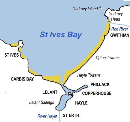
and four miles (6.5 km) east of St Ives, Cornwall
across St Ives Bay
.
Gwithian has a pub, The Red River Inn, which was formerly named the Pendarves Arms. The pub takes its name from the nearby Red River
which, in turn, got its name from the discolouration caused by mining
effluent.
of Gwinear-Gwithian
. The church and relics of St Gwithian or Gocianus, built in 490, were uncovered from the beach and dunes during the early part of the last century, but were then allowed to be reclaimed by the shifting sands. He is the patron saint of good fortune on the sea. The current church was established further inland in the 15th century but only a few fragments of this building remain incorporated in the lychgate of Edmund Sedding
's church of 1866 (the tower however is the original one of the 15th cent.)
Gwithian was the former administrative centre of the Penwith Hundred
: the institutions of the hundred were moved to Penzance in 1771 (or earlier) following large successive inundations of in blown sand. Chesten Marchant
, who died in 1676 at Gwithian is believed to have been the last monoglot Cornish speaker (as opposed to Dolly Pentreath
of Paul who could speak English
as well)
. Gwithian Towans cover the site of a Bronze Age farm which has been excavated although no remains are visible.
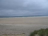
Gwithian Beach stretches three miles from the Hayle River
mouth to the Red River mouth at Godrevy
. The beach is popular throughout the year with surfers, windsurfers, and other beachsport enthusiasts. Gwithian beach is patrolled by RNLI lifeguards from Easter to September and surfing equipment can be purchased or hired from the nearby surf shop.
Gwithian is a coastal village in west Cornwall
Cornwall
Cornwall is a unitary authority and ceremonial county of England, within the United Kingdom. It is bordered to the north and west by the Celtic Sea, to the south by the English Channel, and to the east by the county of Devon, over the River Tamar. Cornwall has a population of , and covers an area of...
, United Kingdom
United Kingdom
The United Kingdom of Great Britain and Northern IrelandIn the United Kingdom and Dependencies, other languages have been officially recognised as legitimate autochthonous languages under the European Charter for Regional or Minority Languages...
. It is situated three miles (5 km) northeast of Hayle
Hayle
Hayle is a small town, civil parish and cargo port in west Cornwall, United Kingdom. It is situated at the mouth of the Hayle River and is approximately seven miles northeast of Penzance...
and four miles (6.5 km) east of St Ives, Cornwall
St Ives, Cornwall
St Ives is a seaside town, civil parish and port in Cornwall, England, United Kingdom. The town lies north of Penzance and west of Camborne on the coast of the Celtic Sea. In former times it was commercially dependent on fishing. The decline in fishing, however, caused a shift in commercial...
across St Ives Bay
St Ives Bay
St Ives Bay is a bay on the Atlantic coast of north-west Cornwall in the United Kingdom. It is in the form of a shallow crescent, some 4 miles or 6 km across, between St Ives in the west and Godrevy Head in the east....
.
Gwithian has a pub, The Red River Inn, which was formerly named the Pendarves Arms. The pub takes its name from the nearby Red River
Red River, Cornwall
The Red River is a small river in north-west Cornwall, UK which issues into St Ives Bay at Godrevy on Cornwall's Atlantic coast. The Red River is approx 8 miles long and gets its name from the mineral deposits associated with tin mining which formerly coloured its water red...
which, in turn, got its name from the discolouration caused by mining
Mining in Cornwall
Mining in Cornwall and Devon began in the early Bronze Age approximately 2,150 BC and ended with the South Crofty tin mine in Cornwall closing in 1998...
effluent.
History
Gwithian is in the civil parishCivil parish
In England, a civil parish is a territorial designation and, where they are found, the lowest tier of local government below districts and counties...
of Gwinear-Gwithian
Gwinear-Gwithian
Gwinear–Gwithian is a coastal civil parish in west Cornwall, United Kingdom. It includes the villages of Connor Downs, Gwinear, Gwithian, Reawla and Rosewarne...
. The church and relics of St Gwithian or Gocianus, built in 490, were uncovered from the beach and dunes during the early part of the last century, but were then allowed to be reclaimed by the shifting sands. He is the patron saint of good fortune on the sea. The current church was established further inland in the 15th century but only a few fragments of this building remain incorporated in the lychgate of Edmund Sedding
Edmund Sedding
-Biography:Sedding, son of Richard and Peninnah Sedding of Summerstown, near Okehampton, Devon, was born on 20 June 1836: John Dando Sedding was his younger brother. He early displayed antiquarian tastes, which led to his visiting cathedrals, abbeys, and churches in England and France...
's church of 1866 (the tower however is the original one of the 15th cent.)
Gwithian was the former administrative centre of the Penwith Hundred
Penwith (hundred)
The hundred of Penwith was the name of one of ten ancient administrative shires of Cornwall, England. The ancient hundred of Penwith was larger than the local government district of Penwith which took its name...
: the institutions of the hundred were moved to Penzance in 1771 (or earlier) following large successive inundations of in blown sand. Chesten Marchant
Chesten Marchant
Chesten Marchant or Cheston Marchant, who died in 1676 at Gwithian, Cornwall is believed to have been the last monoglot Cornish speaker, as opposed to other speakers such as Dolly Pentreath who could also speak English.-References:...
, who died in 1676 at Gwithian is believed to have been the last monoglot Cornish speaker (as opposed to Dolly Pentreath
Dolly Pentreath
Dolly Pentreath, or Dorothy Pentreath was probably the last fluent native speaker of the Cornish language, prior to its revival in 1904 and the subsequent small number of children brought up as bilingual native speakers of revived Cornish.She is often stated to have been the last monoglot speaker...
of Paul who could speak English
English language
English is a West Germanic language that arose in the Anglo-Saxon kingdoms of England and spread into what was to become south-east Scotland under the influence of the Anglian medieval kingdom of Northumbria...
as well)
Tourism
A short distance to the east of the village is Gwithian Towans, which is an area of coastal duneland that forms part of The TowansThe Towans
The word 'towan' means 'sand dune' in Kernewek, the Cornish language and occurs in numerous placenames . However, The Towans usually refers to the three-mile stretch of coastal dunes which extends north east from the estuary of the River Hayle to Gwithian beach with a mid-point near Upton...
. Gwithian Towans cover the site of a Bronze Age farm which has been excavated although no remains are visible.
Gwithian Beach stretches three miles from the Hayle River
River Hayle
The River Hayle is a small river in west Cornwall, UK which issues into St Ives Bay at Hayle on Cornwall's Atlantic coast.The River Hayle is approx 12 miles long and it rises south-west of Crowan village. Its course is west for approx 5 miles...
mouth to the Red River mouth at Godrevy
Godrevy
Godrevy is an area of west Cornwall, United Kingdom, found on the north coast within St. Ives Bay and is popular with both the surfing community and walkers. It is home also to some areas administered by the National Trust, and a lighthouse maintained by Trinity House.- Godrevy Head :The headland ...
. The beach is popular throughout the year with surfers, windsurfers, and other beachsport enthusiasts. Gwithian beach is patrolled by RNLI lifeguards from Easter to September and surfing equipment can be purchased or hired from the nearby surf shop.