
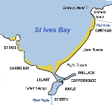
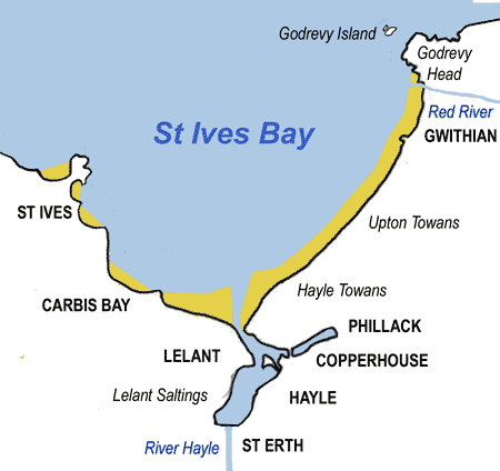
St Ives Bay
Encyclopedia
Bay
A bay is an area of water mostly surrounded by land. Bays generally have calmer waters than the surrounding sea, due to the surrounding land blocking some waves and often reducing winds. Bays also exist as an inlet in a lake or pond. A large bay may be called a gulf, a sea, a sound, or a bight...
on the Atlantic coast of north-west Cornwall
Cornwall
Cornwall is a unitary authority and ceremonial county of England, within the United Kingdom. It is bordered to the north and west by the Celtic Sea, to the south by the English Channel, and to the east by the county of Devon, over the River Tamar. Cornwall has a population of , and covers an area of...
in the United Kingdom
United Kingdom
The United Kingdom of Great Britain and Northern IrelandIn the United Kingdom and Dependencies, other languages have been officially recognised as legitimate autochthonous languages under the European Charter for Regional or Minority Languages...
. It is in the form of a shallow crescent, some 4 miles or 6 km across, between St Ives
St Ives, Cornwall
St Ives is a seaside town, civil parish and port in Cornwall, England, United Kingdom. The town lies north of Penzance and west of Camborne on the coast of the Celtic Sea. In former times it was commercially dependent on fishing. The decline in fishing, however, caused a shift in commercial...
in the west and Godrevy Head
Godrevy
Godrevy is an area of west Cornwall, United Kingdom, found on the north coast within St. Ives Bay and is popular with both the surfing community and walkers. It is home also to some areas administered by the National Trust, and a lighthouse maintained by Trinity House.- Godrevy Head :The headland ...
in the east.
At the most southerly point of St Ives Bay, the River Hayle
River Hayle
The River Hayle is a small river in west Cornwall, UK which issues into St Ives Bay at Hayle on Cornwall's Atlantic coast.The River Hayle is approx 12 miles long and it rises south-west of Crowan village. Its course is west for approx 5 miles...
flows into the sea through sand dunes and across the beach. Behind the dunes, the river forms a broad tidal estuary
Hayle Estuary
The Hayle Estuary is an estuary in west Cornwall, United Kingdom.The estuary of the River Hayle consists of a main channel, with several other nearby tidal areas, including Lelant Saltings, Copperhouse Creek and Carnsew Pool ....
which includes an area of salt marsh
Salt marsh
A salt marsh is an environment in the upper coastal intertidal zone between land and salt water or brackish water, it is dominated by dense stands of halophytic plants such as herbs, grasses, or low shrubs. These plants are terrestrial in origin and are essential to the stability of the salt marsh...
and a largely disused port
Port
A port is a location on a coast or shore containing one or more harbors where ships can dock and transfer people or cargo to or from land....
(see article on the industrial history of Hayle). The estuary is a popular place for birdwatching
Birdwatching
Birdwatching or birding is the observation of birds as a recreational activity. It can be done with the naked eye, through a visual enhancement device like binoculars and telescopes, or by listening for bird sounds. Birding often involves a significant auditory component, as many bird species are...
and the Royal Society for the Protection of Birds maintains a reserve there.
The eastern coast of the bay is a three-mile (5 km) unbroken sandy beach
Beach
A beach is a geological landform along the shoreline of an ocean, sea, lake or river. It usually consists of loose particles which are often composed of rock, such as sand, gravel, shingle, pebbles or cobblestones...
backed by a substantial system of coastal dunes known as The Towans
The Towans
The word 'towan' means 'sand dune' in Kernewek, the Cornish language and occurs in numerous placenames . However, The Towans usually refers to the three-mile stretch of coastal dunes which extends north east from the estuary of the River Hayle to Gwithian beach with a mid-point near Upton...
which stretches from Porth Kidney Sands in the west to Godrevy Head in the east. This stretch of beach is popular for surfing
Surfing
Surfing' is a surface water sport in which the surfer rides a surfboard on the crest and face of a wave which is carrying the surfer towards the shore...
, particularly in the Gwithian
Gwithian
beach2Gwithian is a coastal village in west Cornwall, United Kingdom. It is situated three miles northeast of Hayle and four miles east of St Ives, Cornwall across St Ives Bay....
area.
The western side of the bay is on higher ground and is more densely inhabited with substantial settlements at Lelant
Lelant
Lelant is a village in west Cornwall, England, UK. It is on the west side of the River Hayle estuary about 2½ miles southeast of St Ives and one mile west of Hayle....
, Carbis Bay
Carbis Bay
Carbis Bay is a village and seaside resort in Cornwall, United Kingdom. It lies one mile SE of St Ives on the west side of St Ives Bay on the Atlantic coast....
and St Ives
St Ives, Cornwall
St Ives is a seaside town, civil parish and port in Cornwall, England, United Kingdom. The town lies north of Penzance and west of Camborne on the coast of the Celtic Sea. In former times it was commercially dependent on fishing. The decline in fishing, however, caused a shift in commercial...
. The western coast of the bay is rockier with several small beaches separated by headland
Headland
A headland is a point of land, usually high and often with a sheer drop, that extends out into a body of water.Headland can also refer to:*Headlands and bays*headLand, an Australian television series...
s.
The Stones reef
Reef
In nautical terminology, a reef is a rock, sandbar, or other feature lying beneath the surface of the water ....
lies about one mile north-west of Godrevy Head and presents a hazard to navigation - the lighthouse
Lighthouse
A lighthouse is a tower, building, or other type of structure designed to emit light from a system of lamps and lenses or, in older times, from a fire, and used as an aid to navigation for maritime pilots at sea or on inland waterways....
on Godrevy Island warns mariners of the danger. Inshore hazards include the strong tidal stream around Godrevy Island and the tidal current at the mouth of the River Hayle.
Transport and access
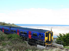
Cornish Main Line
The Cornish Main Line is a railway line in the United Kingdom, which forms the backbone for rail services in Cornwall, as well as providing a direct line to London.- History :...
railway passes south of the bay with stations at St Erth
St Erth
St Erth is a civil parish and village in Cornwall, United Kingdom.The village is situated four miles southeast of St Ives and six miles northeast of Penzance....
and Hayle
Hayle
Hayle is a small town, civil parish and cargo port in west Cornwall, United Kingdom. It is situated at the mouth of the Hayle River and is approximately seven miles northeast of Penzance...
and a branch, the St Ives Bay Line
St Ives Bay Line
The St Ives Bay Line is a railway line from to in Cornwall, United Kingdom. It was opened in 1877, the last new broad gauge passenger railway to be constructed in the country...
, runs from St Erth to St Ives.
By road: The B3301 coast road runs from Godrevy to Hayle behind the dunes, with many points of access to the coast. The A30 trunk road
A30 road
The 284 miles A30 road from London to Land's End, historically known as the Great South West Road used to provide the most direct route from London to the south west; more recently the M3 motorway and A303 road performs this function for much of the route and only parts of A30 now retain trunk...
passes south of Hayle.
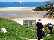
On foot: The South West Coast Path follows the coast around St Ives Bay although it makes a detour inland around the Hayle estuary.
Places around St Ives Bay
- Carbis BayCarbis BayCarbis Bay is a village and seaside resort in Cornwall, United Kingdom. It lies one mile SE of St Ives on the west side of St Ives Bay on the Atlantic coast....
- Connor DownsConnor DownsConnor Downs is a village in west Cornwall, United Kingdom. It is situated approximately two miles east of Hayle.The village straddles the old course of the A30 road but has now been bypassed. Facilities include a school , a petrol station and a fish-and-chip shop....
- GwithianGwithianbeach2Gwithian is a coastal village in west Cornwall, United Kingdom. It is situated three miles northeast of Hayle and four miles east of St Ives, Cornwall across St Ives Bay....
- HayleHayleHayle is a small town, civil parish and cargo port in west Cornwall, United Kingdom. It is situated at the mouth of the Hayle River and is approximately seven miles northeast of Penzance...
- LelantLelantLelant is a village in west Cornwall, England, UK. It is on the west side of the River Hayle estuary about 2½ miles southeast of St Ives and one mile west of Hayle....
- PhillackPhillackPhillack is a village in west Cornwall, United Kingdom. It is situated approximately one mile northeast of Hayle and half-a-mile inland from St Ives Bay on Cornwall's Atlantic coast...
- St ErthSt ErthSt Erth is a civil parish and village in Cornwall, United Kingdom.The village is situated four miles southeast of St Ives and six miles northeast of Penzance....
- St IvesSt Ives, CornwallSt Ives is a seaside town, civil parish and port in Cornwall, England, United Kingdom. The town lies north of Penzance and west of Camborne on the coast of the Celtic Sea. In former times it was commercially dependent on fishing. The decline in fishing, however, caused a shift in commercial...
Rivers
- The Red RiverRed River, CornwallThe Red River is a small river in north-west Cornwall, UK which issues into St Ives Bay at Godrevy on Cornwall's Atlantic coast. The Red River is approx 8 miles long and gets its name from the mineral deposits associated with tin mining which formerly coloured its water red...
- River HayleRiver HayleThe River Hayle is a small river in west Cornwall, UK which issues into St Ives Bay at Hayle on Cornwall's Atlantic coast.The River Hayle is approx 12 miles long and it rises south-west of Crowan village. Its course is west for approx 5 miles...
Other features
- Hayle TowansThe TowansThe word 'towan' means 'sand dune' in Kernewek, the Cornish language and occurs in numerous placenames . However, The Towans usually refers to the three-mile stretch of coastal dunes which extends north east from the estuary of the River Hayle to Gwithian beach with a mid-point near Upton...
- Godrevy HeadGodrevyGodrevy is an area of west Cornwall, United Kingdom, found on the north coast within St. Ives Bay and is popular with both the surfing community and walkers. It is home also to some areas administered by the National Trust, and a lighthouse maintained by Trinity House.- Godrevy Head :The headland ...
- Godrevy lighthouse
- Hayle estuary Site of Special Scientific InterestHayle Estuary and Carrack Gladden SSSIThe Hayle Estuary and Carrack Gladden SSSI is a Site of Special Scientific Interest, noted for its biological interest, in Cornwall, England, UK.It consists of three distinct parts, each of which is covered in a separate article:* the Hayle Estuary...