

Gros Ventre landslide
Encyclopedia
Gros Ventre Wilderness
The Gros Ventre Wilderness is located in Bridger-Teton National Forest in the U.S. state of Wyoming. Most of the Gros Ventre Range is located within the wilderness.U.S. Wilderness Areas do not allow motorized or mechanized vehicles, including bicycles...
of Bridger-Teton National Forest
Bridger-Teton National Forest
Bridger-Teton National Forest is located in western Wyoming, United States. The forest consists of , making it the second largest National Forest outside of Alaska. The forest stretches from Yellowstone National Park, along the eastern boundary of Grand Teton National Park and from there rides...
, Wyoming
Wyoming
Wyoming is a state in the mountain region of the Western United States. The western two thirds of the state is covered mostly with the mountain ranges and rangelands in the foothills of the Eastern Rocky Mountains, while the eastern third of the state is high elevation prairie known as the High...
, United States
United States
The United States of America is a federal constitutional republic comprising fifty states and a federal district...
. The Gros Ventre landslide
Landslide
A landslide or landslip is a geological phenomenon which includes a wide range of ground movement, such as rockfalls, deep failure of slopes and shallow debris flows, which can occur in offshore, coastal and onshore environments...
is 7 miles (11.3 km) east of Jackson Hole
Jackson Hole
Jackson Hole, originally called Jackson's Hole, is a valley located in the U.S. state of Wyoming, near the western border with Idaho. The name "hole" derives from language used by early trappers or mountain men, who primarily entered the valley from the north and east and had to descend along...
valley and Grand Teton National Park
Grand Teton National Park
Grand Teton National Park is a United States National Park located in northwestern Wyoming, U.S. The Park consists of approximately and includes the major peaks of the long Teton Range as well as most of the northern sections of the valley known as Jackson Hole. Only south of Yellowstone...
.
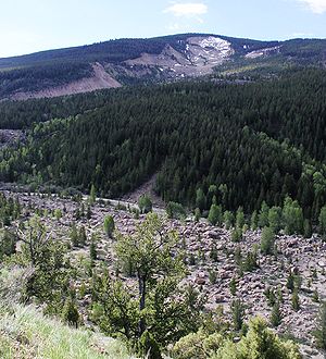
The landslide occurred on June 23, 1925, following the melt from a heavy snowpack and several weeks of heavy rain. Approximately 50000000 cu yd (38,227,742.9 m³) of primarily sedimentary rock slid down the north face of Sheep Mountain
Sheep Mountain (Teton County, Wyoming)
Sheep Mountain is located in the U.S. state of Wyoming. Sheep Mountain forms a long ridge in the Gros Ventre Range and is easily seen from Jackson Hole. The town of Jackson, Wyoming is southwest of the peak...
, crossed over the Gros Ventre River
Gros Ventre River
The Gros Ventre River is a tributary of the Snake River in the state of Wyoming. It rises in the Gros Ventre Wilderness in western Wyoming, and joins the Snake River in the Jackson Hole valley. In 1925, the massive Gros Ventre landslide dammed the river and formed Lower Slide Lake...
and raced up the opposing mountainside a distance of 300 feet (91.4 m). The landslide created a huge dam
Dam
A dam is a barrier that impounds water or underground streams. Dams generally serve the primary purpose of retaining water, while other structures such as floodgates or levees are used to manage or prevent water flow into specific land regions. Hydropower and pumped-storage hydroelectricity are...
over 200 feet (61 m) high and 400 yards (365.8 m) wide across the Gros Ventre River, backing up the water and forming Lower Slide Lake
Lower Slide Lake
Lower Slide Lake is located in Bridger-Teton National Forest, in the U. S. state of Wyoming. The natural lake was created on June 23, 1925 when the Gros Ventre landslide dammed the Gros Ventre River. The lake was once much larger, however part of the rock dam failed less than two years later, on...
.
On May 18, 1927, a portion of the landslide dam
Landslide dam
A landslide dam, debris dam, or barrier lake is a natural damming of a river by some kind of mass wasting: landslide, debris flow, rock avalanche or volcano. If it is caused by earthquake, it may also be called a quake lake. Some landslide dams are as high as the largest existing artificial dam...
failed, resulting in a massive flood that was 6 feet (1.8 m) deep for at least 25 miles (40.2 km) downstream. The small town of Kelly
Kelly, Wyoming
Kelly is an unincorporated community in Teton County in the U.S. state of Wyoming. Kelly is .situated along the Gros Ventre River on the eastern side of the Jackson Hole valley, is part of the Jackson, WY–ID Micropolitan Statistical Area and has a US Post Office with zip code 83011.The settlement...
, six miles (10 km) downstream, was wiped out killing six people. It is one of the world's largest known examples of recent mass wasting
Mass wasting
Mass wasting, also known as slope movement or mass movement, is the geomorphic process by which soil, regolith, and rock move downslope under the force of gravity. Types of mass wasting include creep, slides, flows, topples, and falls, each with its own characteristic features, and taking place...
events aside from volcanic eruptions. Slide Lake is now much smaller than before the flood but is considered an outstanding location for boating and fishing.
Today, the landslide is partially reclaimed by the surrounding forest
Forest
A forest, also referred to as a wood or the woods, is an area with a high density of trees. As with cities, depending where you are in the world, what is considered a forest may vary significantly in size and have various classification according to how and what of the forest is composed...
but is still an obvious landmark from many vantage points in the Jackson Hole valley. It is easily accessible by traveling north from Jackson, Wyoming
Jackson, Wyoming
Jackson is a town located in the Jackson Hole valley of Teton County, Wyoming, United States. The population was 8,647 at the 2000 census. It is the county seat of Teton County....
or south from Moran, Wyoming and then taking the Antelope Flats road east off U.S. Route 26
U.S. Route 26
U.S. Route 26 is an east–west United States highway. It started in Ogallala, Nebraska, and gradually grew to reach the West Coast in Oregon. When the U.S. highway system was first defined, it was limited to Nebraska and Wyoming; by the 1950s, it continued into Idaho and Oregon. The...
.