
Griqualand East
Encyclopedia
Griqualand East was one of four short-lived Griqua states in Southern Africa from the early 1860s until the late 1870s and was located between the Umzimkulu
and Kinira Rivers, south of the Sotho Kingdom
.
Griqualand East's capital, Kokstad
, was the final place of settlement for a people that had migrated several times on their journey from the Cape of Good Hope
and over the mountains of present-day Lesotho
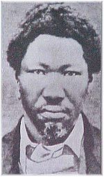
. Shortly before the death of its founder and only leader, Adam Kok III
, the small country was annexed and incorporated into the British Empire
's Cape Colony
. Though for a long time overshadowed in history by the story of the Voortrekkers
, the trek of the Griquas has been described as "one of the great epics of the 19th century."
, leader of the Zulu Kingdom
. As Faku eventually realised that his warriors would be unable to defend the eastern part of his kingdom against Shaka, he decided to evacuate the area, leaving behind what became known as Nomansland, often spelled "No-man's land" in contemporary sources.
Meanwhile, a group of Griquas who had left the Cape of Good Hope and had settled in the area around present-day Philippolis
were faced with the area's coming under the control of the emerging Orange Free State
(Oranje Vrijstaat). It is undisputed that most of these inhabitants embarked on a tiresome and exhausting journey and left the area to move southwards over Quathlamba (today known as the Drakensberg
mountain range), but the reasons and motivations for their last trek are given two differing narratives among first-hand witnesses.
, administrator of the area on behalf of the United Kingdom
, to settle in the aforementioned Nomansland, south of what had by then become the British Colony of Natal
. Their settlement there was to avoid a potential conflict with the Free State and simultaneously serve as a buffer against Bushmen
and "their predatory raids upon the farmers and natives of Natal"Robinson, John. A life time in South Africa, being the recollections of the first premier of Natal. Smith, Elder & Co. London:1900. p225 After their leader Adam Kok III had sent an advance party to survey the area, the entire group agreed to the arrangement and arrived there in 1862.
 More recently recovered official documents, however, tell the story of a deal that was struck between the British Empire and the Free State in 1854, long before the Griquas had any knowledge of their fate. The British agreed to expel the entire population in exchange for a settlement of a border conflict between the Afrikaners and the Cape colonists. According to the sources, Adam Kok III and his followers only learned about the plans six years after the official document had been secretly signed. Realising that they could not muster a fighting-force that could match the colonial army, and after having voiced their opposition to becoming either subjects to the Crown in the Cape Colony or servants in the Free State, they were forcibly removed into exile in 1863.
Ultimately, all sources agree that the last great Griqua-leader's followers ended up in the area around Mount Currie and set up a Laager, a simple settlement site made up of small huts, where they remained for over half a decade. In 1869, Reverent Dower of the London Mission Society visited the place and agreed to establish a church if the people were to move once more; after consultation with the populace, an area farther south of the mountain was chosen, and upon arrival in 1872, the town of Kokstad was founded, named in honour of their leader.
 Though, in historical terms, constantly on the move, with permanent settlements existing only for short intervals, the people of Griqualand East managed to establish a Raad (or Volksraad
), a gathering of 12 members which made decisions on behalf of the population and formed delegations to deal with the surrounding polities.
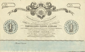
had begun printing its own banknotes, Kok and his followers embarked on a similar experiment of their own and had about 10,000 one pound-notes printed for use in the area. The plans to actually introduce them never materialised, and, with the exception of a few remaining samples, almost all of them were destroyed without ever being in circulation.
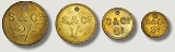
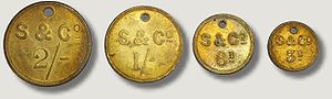
After the move to Kokstad, however, a new venture in introducing a local currency was more successful in 1874; designed by Strachan and Co.
and minted in Germany, several coins were used (see picture) and remained in circulation long after the disestablishment of the country.
with mantling
. The actual implied colours are unknown.
The Griqua flag is a vertically flipped version of the "Vierkleur" used by Transvaal and the South African Republic
. A single source dates its first documented appearance to 1903, but the flag itself might have been in use earlier; whether or not independent Griqualand East actually deployed it is uncertain.
, 1886, it was annexed into the Cape Colony in 1877, while the Scottish Geographical Magazine claims that the Griquas' last independent home continued to exist for another two years, until 1879. Apart from the chronological discrepancies, the reasons for the country's dissolution remain hazy as well. British sources claim that the Griquas sold their land voluntarily, and hence, that the annexation of the territory took place "at the wish of the inhabitants themselves." On the other hand, a quote by Adam Kok III, upon learning of the United Kingdom's plans, casts doubt upon these assertions: "There you have it... we were not consulted. We can say nothing."
What is known for a fact is that the Griqua leader, whose name still adorns the town he founded, died in December 1875 after being severely injured in a wagon-accident. At his funeral, his cousin commented that with Kok's death, the Griquas' last hope for an independent state in Southern Africa had died as well.
was formed in 1910, the Cape Colony changed its name to "Cape Province," and during the 1980s, part of former Griqualand East was partitioned off into the Transkei
, one of the four nominally independent Bantustan
s. In 1994, shortly before the first all-inclusive elections, it was incorporated into the southern part of the KwaZulu-Natal
province. Kokstad retained its name and is today one of the main cities of the Sisonke District Municipality
.
Umzimkulu River
The Umzimkulu River is a river in South Africa. It rises in the Drakensberg mountains and flows southeast towards the Indian Ocean, which it enters in Port Shepstone. Towns on the Umzimkulu include Underberg and Umzimkulu...
and Kinira Rivers, south of the Sotho Kingdom
Basotho
The ancestors of the Sotho people have lived in southern Africa since around the fifth century. The Sotho nation emerged from the accomplished diplomacy of Moshoeshoe I who gathered together disparate clans of Sotho–Tswana origin that had dispersed across southern Africa in the early 19th century...
.
Griqualand East's capital, Kokstad
Kokstad, KwaZulu-Natal
Kokstad is a town in the Sisonke District of KwaZulu-Natal Province, South Africa. Kokstad is named after the Griqua chief Adam Kok III who settled here in 1863. Stad is the Dutch and Afrikaans word for city....
, was the final place of settlement for a people that had migrated several times on their journey from the Cape of Good Hope
Cape of Good Hope
The Cape of Good Hope is a rocky headland on the Atlantic coast of the Cape Peninsula, South Africa.There is a misconception that the Cape of Good Hope is the southern tip of Africa, because it was once believed to be the dividing point between the Atlantic and Indian Oceans. In fact, the...
and over the mountains of present-day Lesotho
Lesotho
Lesotho , officially the Kingdom of Lesotho, is a landlocked country and enclave, surrounded by the Republic of South Africa. It is just over in size with a population of approximately 2,067,000. Its capital and largest city is Maseru. Lesotho is a member of the Commonwealth of Nations. The name...
. Shortly before the death of its founder and only leader, Adam Kok III
Adam Kok III
Adam Kok III was a leader of the Griqua people in South Africa .The son of Adam Kok II, he grew up and was educated in the town of Philippolis in Transorangia...
, the small country was annexed and incorporated into the British Empire
British Empire
The British Empire comprised the dominions, colonies, protectorates, mandates and other territories ruled or administered by the United Kingdom. It originated with the overseas colonies and trading posts established by England in the late 16th and early 17th centuries. At its height, it was the...
's Cape Colony
Cape Colony
The Cape Colony, part of modern South Africa, was established by the Dutch East India Company in 1652, with the founding of Cape Town. It was subsequently occupied by the British in 1795 when the Netherlands were occupied by revolutionary France, so that the French revolutionaries could not take...
. Though for a long time overshadowed in history by the story of the Voortrekkers
Voortrekkers
The Voortrekkers were emigrants during the 1830s and 1840s who left the Cape Colony moving into the interior of what is now South Africa...
, the trek of the Griquas has been described as "one of the great epics of the 19th century."
Background
Before the arrival of migrants from the West and North, the area was part of the Mpondo kingdom under King Faku, who ruled as sovereign of the ethnically Xhosa dynasty from 1815–1867. During his reign, he initially welcomed many refugees who came over the territory's north-eastern border, fleeing from the incursions and raids by the army of ShakaShaka
Shaka kaSenzangakhona , also known as Shaka Zulu , was the most influential leader of the Zulu Kingdom....
, leader of the Zulu Kingdom
Zulu Kingdom
The Zulu Kingdom, sometimes referred to as the Zulu Empire or, rather imprecisely, Zululand, was a monarchy in Southern Africa that extended along the coast of the Indian Ocean from the Tugela River in the south to Pongola River in the north....
. As Faku eventually realised that his warriors would be unable to defend the eastern part of his kingdom against Shaka, he decided to evacuate the area, leaving behind what became known as Nomansland, often spelled "No-man's land" in contemporary sources.
Meanwhile, a group of Griquas who had left the Cape of Good Hope and had settled in the area around present-day Philippolis
Philippolis
Philippolis is a small town in the Free State province of South Africa. It was founded as a missionary outpost for the Bushman in 1823, making it the oldest settlement in the Free State. It was named after John Philip of the London Missionary Society. Adam Kok II, a Griqua leader, settled here with...
were faced with the area's coming under the control of the emerging Orange Free State
Orange Free State
The Orange Free State was an independent Boer republic in southern Africa during the second half of the 19th century, and later a British colony and a province of the Union of South Africa. It is the historical precursor to the present-day Free State province...
(Oranje Vrijstaat). It is undisputed that most of these inhabitants embarked on a tiresome and exhausting journey and left the area to move southwards over Quathlamba (today known as the Drakensberg
Drakensberg
The Drakensberg is the highest mountain range in Southern Africa, rising to in height. In Zulu, it is referred to as uKhahlamba , and in Sesotho as Maluti...
mountain range), but the reasons and motivations for their last trek are given two differing narratives among first-hand witnesses.
Arrival and settlement
According to the account of John Robinson, first Premier of Natal, the inhabitants of Philippolis were invited by Sir George GreyGeorge Grey
George Grey may refer to:*Sir George Grey, 2nd Baronet , British politician*George Grey, 2nd Earl of Kent *Sir George Grey , Governor of Cape Colony, South Australia and New Zealand...
, administrator of the area on behalf of the United Kingdom
United Kingdom of Great Britain and Ireland
The United Kingdom of Great Britain and Ireland was the formal name of the United Kingdom during the period when what is now the Republic of Ireland formed a part of it....
, to settle in the aforementioned Nomansland, south of what had by then become the British Colony of Natal
Colony of Natal
The Colony of Natal was a British colony in south-eastern Africa. It was proclaimed a British colony on May 4, 1843 after the British government had annexed the Boer Republic of Natalia, and on 31 May 1910 combined with three other colonies to form the Union of South Africa, as one of its...
. Their settlement there was to avoid a potential conflict with the Free State and simultaneously serve as a buffer against Bushmen
Bushmen
The indigenous people of Southern Africa, whose territory spans most areas of South Africa, Zimbabwe, Lesotho, Mozambique, Swaziland, Botswana, Namibia, and Angola, are variously referred to as Bushmen, San, Sho, Barwa, Kung, or Khwe...
and "their predatory raids upon the farmers and natives of Natal"Robinson, John. A life time in South Africa, being the recollections of the first premier of Natal. Smith, Elder & Co. London:1900. p225 After their leader Adam Kok III had sent an advance party to survey the area, the entire group agreed to the arrangement and arrived there in 1862.
Ultimately, all sources agree that the last great Griqua-leader's followers ended up in the area around Mount Currie and set up a Laager, a simple settlement site made up of small huts, where they remained for over half a decade. In 1869, Reverent Dower of the London Mission Society visited the place and agreed to establish a church if the people were to move once more; after consultation with the populace, an area farther south of the mountain was chosen, and upon arrival in 1872, the town of Kokstad was founded, named in honour of their leader.
Government
Volksraad
The Volksraad was the parliament of the former South African Republic , which existed from 1857 to 1902 in part of what is now the South Africa. The body ceased to exist after the British victory in the Second Anglo-Boer War. The Volksraad sat in session in Ou Raadsaal in Church Square, Pretoria...
), a gathering of 12 members which made decisions on behalf of the population and formed delegations to deal with the surrounding polities.
Currency
In 1867, after the Bank of DurbanDurban
Durban is the largest city in the South African province of KwaZulu-Natal and the third largest city in South Africa. It forms part of the eThekwini metropolitan municipality. Durban is famous for being the busiest port in South Africa. It is also seen as one of the major centres of tourism...
had begun printing its own banknotes, Kok and his followers embarked on a similar experiment of their own and had about 10,000 one pound-notes printed for use in the area. The plans to actually introduce them never materialised, and, with the exception of a few remaining samples, almost all of them were destroyed without ever being in circulation.
After the move to Kokstad, however, a new venture in introducing a local currency was more successful in 1874; designed by Strachan and Co.
Token coin
In the study of numismatics, tokens are coin-like objects used instead of coins. The field of tokens is part of exonumia. Tokens are used in place of coins and either have a denomination shown or implied by size, color or shape...
and minted in Germany, several coins were used (see picture) and remained in circulation long after the disestablishment of the country.
Symbolism
The seal included in the information-box is a rough replica of a seal shown on the first set of banknotes of 1867 which is the only known and surviving depiction. On the banknote itself, it is flanked to the left and right by a band or ribbon which reads "GOUVERNEMENT VAN | NIEUW GRIQUALAND" and includes a helmHelmet (heraldry)
In heraldic achievements, the helmet or helm is situated above the shield and bears the torse and crest. The style of helmet displayed varies according to rank and social status, and these styles developed over time, in step with the development of actual military helmets...
with mantling
Mantling
In heraldry, mantling or lambrequin is drapery tied to the helmet above the shield. It forms a backdrop for the shield. In paper heraldry it is a depiction of the protective cloth covering worn by knights from their helmets to stave off the elements, and, secondarily, to decrease the effects of...
. The actual implied colours are unknown.
The Griqua flag is a vertically flipped version of the "Vierkleur" used by Transvaal and the South African Republic
South African Republic
The South African Republic , often informally known as the Transvaal Republic, was an independent Boer-ruled country in Southern Africa during the second half of the 19th century. Not to be confused with the present-day Republic of South Africa, it occupied the area later known as the South African...
. A single source dates its first documented appearance to 1903, but the flag itself might have been in use earlier; whether or not independent Griqualand East actually deployed it is uncertain.
Annexation
In the differing sources and versions of history, the end of Griqualand East's story is as contested as its beginning. According to the Westminster ReviewWestminster Review
The Westminster Review was a quarterly British publication. Established in 1823 as the official organ of the Philosophical Radicals, it was published from 1824 to 1914. James Mill was one of the driving forces behind the liberal journal until 1828....
, 1886, it was annexed into the Cape Colony in 1877, while the Scottish Geographical Magazine claims that the Griquas' last independent home continued to exist for another two years, until 1879. Apart from the chronological discrepancies, the reasons for the country's dissolution remain hazy as well. British sources claim that the Griquas sold their land voluntarily, and hence, that the annexation of the territory took place "at the wish of the inhabitants themselves." On the other hand, a quote by Adam Kok III, upon learning of the United Kingdom's plans, casts doubt upon these assertions: "There you have it... we were not consulted. We can say nothing."
What is known for a fact is that the Griqua leader, whose name still adorns the town he founded, died in December 1875 after being severely injured in a wagon-accident. At his funeral, his cousin commented that with Kok's death, the Griquas' last hope for an independent state in Southern Africa had died as well.
Contemporary Griqualand
When the Union of South AfricaUnion of South Africa
The Union of South Africa is the historic predecessor to the present-day Republic of South Africa. It came into being on 31 May 1910 with the unification of the previously separate colonies of the Cape, Natal, Transvaal and the Orange Free State...
was formed in 1910, the Cape Colony changed its name to "Cape Province," and during the 1980s, part of former Griqualand East was partitioned off into the Transkei
Transkei
The Transkei , officially the Republic of Transkei , was a Bantustan—an area set aside for members of a specific ethnicity—and nominal parliamentary democracy in the southeastern region of South Africa...
, one of the four nominally independent Bantustan
Bantustan
A bantustan was a territory set aside for black inhabitants of South Africa and South West Africa , as part of the policy of apartheid...
s. In 1994, shortly before the first all-inclusive elections, it was incorporated into the southern part of the KwaZulu-Natal
KwaZulu-Natal
KwaZulu-Natal is a province of South Africa. Prior to 1994, the territory now known as KwaZulu-Natal was made up of the province of Natal and the homeland of KwaZulu....
province. Kokstad retained its name and is today one of the main cities of the Sisonke District Municipality
Sisonke District Municipality
Sisonke is one of the 11 districts of KwaZulu-Natal province of South Africa. The seat of Sisonke is Ixopo. The majority of its 298 392 people speak IsiZulu...
.