
Greater Vancouver Gateway Program
Encyclopedia
Canadian dollar
The Canadian dollar is the currency of Canada. As of 2007, the Canadian dollar is the 7th most traded currency in the world. It is abbreviated with the dollar sign $, or C$ to distinguish it from other dollar-denominated currencies...
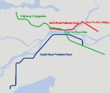
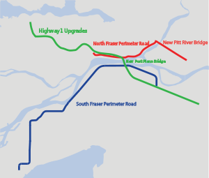
3.0 billion regional transportation project for Metro Vancouver that is being managed by the British Columbia Ministry of Transportation
British Columbia Ministry of Transportation
The British Columbia Ministry of Transportation and Infrastructure is the British Columbia government ministry responsible for transport infrastructure and law in the Canadian province of British Columbia...
. The ministry introduced the Gateway Program on January 31, 2005 as a means to address growing congestion and reduce travel times.
Port Mann / Highway 1
The Port Mann / Highway 1 (PMH1) Project includes the widening of Highway 1, a new Port Mann Bridge and upgrades to interchanges on British Columbia Highway 1 in order to address congestion through this corridor.The Port Mann Bridge
Port Mann Bridge
The Port Mann Bridge is a steel tied arch bridge that spans the Fraser River connecting Coquitlam to Surrey in British Columbia near Vancouver. The bridge consists of three spans with an orthotropic deck carrying five lanes of Trans-Canada Highway traffic, with approach spans of three steel plate...
will be replaced with a new 10-lane, tolled bridge.
The project will also feature rapid bus lanes. This will include transit priority access to Highway 1, park-and-ride facilities, new transit loops in Surrey and Langley as well as 20 new buses.
The bridge includes separated pedestrian and cycling lanes across the Port Mann Bridge
Port Mann Bridge
The Port Mann Bridge is a steel tied arch bridge that spans the Fraser River connecting Coquitlam to Surrey in British Columbia near Vancouver. The bridge consists of three spans with an orthotropic deck carrying five lanes of Trans-Canada Highway traffic, with approach spans of three steel plate...
, and is also being designed to accommodate the eventual addition of Light Rail Transit
Light Rail Transit
The name Light Rail Transit is used to refer to several light rail systems, as an official name or otherwise:* Please see List of tram and light-rail transit systems.-See also:* Light Rapid Transit * Light railway* Light rail...
underneath the bridge.
The project includes widening Highway 1 between McGill Street in Vancouver
Vancouver
Vancouver is a coastal seaport city on the mainland of British Columbia, Canada. It is the hub of Greater Vancouver, which, with over 2.3 million residents, is the third most populous metropolitan area in the country,...
and 216 Street in Langley
Langley, British Columbia (city)
The City of Langley is a municipality in Metro Vancouver. It lies directly east of the City of Surrey, adjacent to Cloverdale, and surrounded on the north, east and south by Township of Langley.-History:...
. The pre-design concept included one additional lane in each direction between the Port Mann Bridge
Port Mann Bridge
The Port Mann Bridge is a steel tied arch bridge that spans the Fraser River connecting Coquitlam to Surrey in British Columbia near Vancouver. The bridge consists of three spans with an orthotropic deck carrying five lanes of Trans-Canada Highway traffic, with approach spans of three steel plate...
and McGill Street. The bridge itself will feature five new lanes, two reserved for high-occupancy vehicles and commercial vehicles. On the Surrey
Surrey
Surrey is a county in the South East of England and is one of the Home Counties. The county borders Greater London, Kent, East Sussex, West Sussex, Hampshire and Berkshire. The historic county town is Guildford. Surrey County Council sits at Kingston upon Thames, although this has been part of...
side, two additional lanes will be built from the bridge to 200 Street, allowing for one HOV lane in each direction. Finally, there will be one additional lane in each direction on the section from 200 to 216 Streets.
Interchanges from Vancouver
Vancouver
Vancouver is a coastal seaport city on the mainland of British Columbia, Canada. It is the hub of Greater Vancouver, which, with over 2.3 million residents, is the third most populous metropolitan area in the country,...
to Langley
Langley, British Columbia (city)
The City of Langley is a municipality in Metro Vancouver. It lies directly east of the City of Surrey, adjacent to Cloverdale, and surrounded on the north, east and south by Township of Langley.-History:...
will also be upgraded to increase interchange capacity and improve safety.
The majority of these changes will occur within the existing right of way of Highway 1. The PMH1 project is scheduled to be finished in 2013.
South Fraser Perimeter Road
The South Fraser Perimeter RoadSouth fraser perimeter road
The South Fraser Perimeter Road is a $1.0 billion highway project for Metro Vancouver and is part of the British Columbia Ministry of Transportation's Gateway Program and is currently under construction.-Project scope and goals:...
(SFPR), a new four-lane, 80 km/h (50 mph) highway along the south side of the Fraser River
Fraser River
The Fraser River is the longest river within British Columbia, Canada, rising at Fraser Pass near Mount Robson in the Rocky Mountains and flowing for , into the Strait of Georgia at the city of Vancouver. It is the tenth longest river in Canada...
, will extend from Highway 17 in southwest Delta to 176 Street in Surrey, with connections to Highways 1, 91, and 99 and to TransLink's new Golden Ears Bridge
Golden Ears Bridge
The Golden Ears Bridge is a six-lane extradosed bridge in Metro Vancouver, British Columbia. It spans the Fraser River, connecting Langley on the south side with Pitt Meadows and Maple Ridge on the north side. The All Electronic Toll bridge, owned by TransLink, has a clearance of , and a total...
connector. The SFPR will provide a new east–west transportation corridor that will provide new connections to the Roberts Bank Superport
Roberts Bank Superport
Roberts Bank Superport is a twin-terminal port facility located on the mainland coastline of the Strait of Georgia in Delta, British Columbia. Opened in 1970 with Westshore Terminals as its only tenant, Roberts Bank was expanded in 1983–84, and in June 1997 opened a second terminal, the Deltaport...
. The stated goal is to reduce the volume of regional truck traffic on local roads and reduce idling on local roads.
The Burns Bog Conservation Society has expressed concerns that the South Fraser Perimeter Road will endanger Burns Bog
Burns Bog
The Burns Bog is the largest domed peat bog on the west coast of North America. It covers an area of about and occupies a quarter of Delta, British Columbia, about southeast of downtown Vancouver, and is bounded by BC Highway 10 on its south, the Annacis Highway on its east, and River Road, along...
. Attempts to mitigate these impacts have been made through refinements that occurred as a result of public consultation and the Environmental Assessment process. In response to the mitigation measures proposed, the Environmental Stewardship Branch of Environment Canada wrote that "the changes are not sufficient to alleviate its concerns related to the impacts of the Project on Pacific Water Shrew (PWS), hydrology, aerial deposition, and ecological integrity of Burns Bog".
The Gateway Program says that it is committed to protecting and supporting the restoration of Burns Bog. The SFPR project will be working with the Burns Bog Scientific Advisory Panel to develop systems that will improve the existing drainage and hydrology of the bog. Although the SFPR alignment does not go through the Burns Bog Ecological Conservancy Area, there is concern that it will affect the surrounding hydrology and have an adverse affect on the Conservancy Area.
It is estimated that over 90 hectares (222 acres) of farmland will also be lost to the project. There have also been concerns expressed about pollution near residential neighborhoods and schools.
The Wilderness Committee and other groups have criticized the SFPR, and the Gateway Program in general, for increasing greenhouse gas emissions. In the spring of 2011, a protest camp organized by StopThePave.org and the Council of Canadians
The Council of Canadians
The Council of Canadians is a progressive citizens' organization that advocates on behalf of its members across the country. Founded in 1985 to oppose the Canada-U.S...
occupied a SFPR construction site for almost two weeks.
The SFPR is expected to be completed by 2013.
North Fraser Perimeter Road
The North Fraser Perimeter Road (NFPR) was promoted as a way to provide a continuous route on the north side of the Fraser River from New Westminster to Maple RidgeMaple Ridge, British Columbia
Maple Ridge is a District Municipality in British Columbia, located in the northeastern section of Metro Vancouver. Maple Ridge has a population of approximately 68,949.-History:...
. TransLink is responsible for the section between the Queensborough Bridge
Queensborough Bridge
Queensborough Bridge is a highway bridge in New Westminster, British Columbia. It was built in 1960 by the City of New Westminster, costing $4 million. The bridge spans over the north arm of the Fraser River for road access to the suburb of Queensborough at the east end of Lulu Island.It has since...
and the border of Coquitlam.
The Gateway portion of this route was to originate from the Bailey bridge
Bailey bridge
The Bailey bridge is a type of portable, pre-fabricated, truss bridge. It was developed by the British during World War II for military use and saw extensive use by both British and the American military engineering units....
across the Brunette River. The one-lane wooden bridge was to be replaced with a new four-lane crossing. The route follows United Boulevard and turns onto the Mary Hill Bypass. East of the new bridge, Lougheed Highway continues east through Pitt Meadows and Maple Ridge. The intersection at Harris Road will be converted to a full interchange.
Pitt River Bridge and Mary Hill Interchange
The new Pitt River BridgePitt River Bridge
The Pitt River Bridge is a cable-stayed bridge that spans the Pitt River between Port Coquitlam and Pitt Meadows in British Columbia, Canada. The bridge is part of Highway 7, carrying Lougheed Highway across the river...
is a seven-lane cable-stayed bridge
Cable-stayed bridge
A cable-stayed bridge is a bridge that consists of one or more columns , with cables supporting the bridge deck....
that carries the Lougheed Highway over the Pitt River
Pitt River
The Pitt River in British Columbia, Canada is a large tributary of the Fraser River, entering it a few miles upstream from New Westminster and about 25 km ESE of Downtown Vancouver. The river, which begins in the Garibaldi Ranges of the Coast Mountains, is in two sections above and below Pitt...
; it was built between the two swing bridges that previously performed this duty. A new interchange has replaced the at-grade intersection of the Lougheed Highway and the Mary Hill Bypass.
The old swing bridges previously accommodated four lanes of traffic: Two on each bridge, with a counterflow
Reversible lane
A reversible lane , called a counterflow lane or contraflow lane in transport engineering nomenclature, is a lane in which traffic may travel in either direction, depending on certain conditions...
system for peak hours. The new bridge carries three lanes of general purpose traffic in each direction as well as one eastbound lane for slower-moving trucks accessing the Canadian Pacific intermodal yard at Kennedy Road.
The new bridge also includes separate pedestrian and cycling walkways. The new bridge is designed to accommodate the addition of light rapid transit
Light Rapid Transit
The name Light Rapid Transit is used by specific light rail systems, either as an official name or otherwise:* Please see List of tram and light-rail transit systems.-See also:* Light Rail Transit* light railway* light rail* tram/streetcar* Premetro...
.
The project is being funded by the federal and provincial governments. As part of its recent Asia-Pacific Gateway and Corridor Initiative
Asia-Pacific Gateway and Corridor Initiative
The Asia-Pacific Gateway and Corridor Initiative is an integrated set of investment and policy measures of the Canadian federal government that are focused on trade with the Asia-Pacific Region.-The Asia-Pacific Gateway and Corridor:...
, the Government of Canada committed $90 million in funding toward the construction of the new bridge and interchange; the province provided $108 million.
The new bridge and interchange were substantially completed by the end of 2009 to coincide with the opening of the Golden Ears Bridge
Golden Ears Bridge
The Golden Ears Bridge is a six-lane extradosed bridge in Metro Vancouver, British Columbia. It spans the Fraser River, connecting Langley on the south side with Pitt Meadows and Maple Ridge on the north side. The All Electronic Toll bridge, owned by TransLink, has a clearance of , and a total...
.
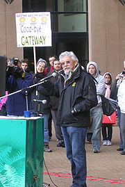
Criticism
Vancouver
Vancouver is a coastal seaport city on the mainland of British Columbia, Canada. It is the hub of Greater Vancouver, which, with over 2.3 million residents, is the third most populous metropolitan area in the country,...
city council and directors of the GVRD (now Metro Vancouver) have passed resolutions opposing the Highway 1 portion of the project.
Groups opposing the program include the Livable Region Coalition, a group based south of the Fraser called the Gateway 40 Network, a group of urban planners, the Society Promoting Environmental Conservation (SPEC), the Burns Bog Conservation Society, Sunbury Neighbourhood Association, South Fraser Action Networks, Bridgeview Community Action Group, Gateway Sucks, the Council of Canadians, and the Western Canada Wilderness Committee. These groups argue that increasing the highway's capacity will only increase traffic over the span and encourage suburban sprawl. The Livable Region Coalition urged the former Minister of Transportation, Kevin Falcon
Kevin Falcon
Kevin Falcon is a Canadian politician and is the current Deputy Premier of British Columbia, Canada. He is a Member of the Legislative Assembly for the district of Surrey-Cloverdale and is a member of the BC Liberals...
, to consider more viable solutions to reducing congestion, including more rapid transit
Rapid transit
A rapid transit, underground, subway, elevated railway, metro or metropolitan railway system is an electric passenger railway in an urban area with a high capacity and frequency, and grade separation from other traffic. Rapid transit systems are typically located either in underground tunnels or on...
and improved bus
Bus
A bus is a road vehicle designed to carry passengers. Buses can have a capacity as high as 300 passengers. The most common type of bus is the single-decker bus, with larger loads carried by double-decker buses and articulated buses, and smaller loads carried by midibuses and minibuses; coaches are...
routes.
The David Suzuki Foundation
David Suzuki Foundation
The David Suzuki Foundation is an environmental organization based in Vancouver, British Columbia, Canada It is a non-profit organization that is incorporated in both Canada and the United States, and is funded by over 40,000 donors...
claims the project violates the goals of the Livable Region Strategic Plan and does not consider alternative forms of transportation.
The provincial government studies, conducted as part of the Environmental Assessment Process, project an increase of 176,000 tonnes per year in greenhouse gas emissions. An analysis by SPEC found that these studies included emissions in Whatcom County, Washington
Whatcom County, Washington
Whatcom County is a county located in the U.S. state of Washington. Its name ultimately derives from the Lummi word Xwotʼqom, meaning "noisy water." As of 2010, the population was 201,140. The county seat is at Bellingham, which is also the county's largest city...
when calculating the baseline and left them out when calculating the impact of Gateway. When this is factored in the studies predict a 31% increase in on road emissions.
Groups supporting the project include Get Moving BC and the BC Truckers Association.
External links
- Official Gateway Program website Ministry of Transportation
- The Livable Region Coalition