
Pitt River
Encyclopedia

British Columbia
British Columbia is the westernmost of Canada's provinces and is known for its natural beauty, as reflected in its Latin motto, Splendor sine occasu . Its name was chosen by Queen Victoria in 1858...
, Canada
Canada
Canada is a North American country consisting of ten provinces and three territories. Located in the northern part of the continent, it extends from the Atlantic Ocean in the east to the Pacific Ocean in the west, and northward into the Arctic Ocean...
is a large tributary of the Fraser River
Fraser River
The Fraser River is the longest river within British Columbia, Canada, rising at Fraser Pass near Mount Robson in the Rocky Mountains and flowing for , into the Strait of Georgia at the city of Vancouver. It is the tenth longest river in Canada...
, entering it a few miles upstream from New Westminster and about 25 km ESE of Downtown Vancouver
Vancouver
Vancouver is a coastal seaport city on the mainland of British Columbia, Canada. It is the hub of Greater Vancouver, which, with over 2.3 million residents, is the third most populous metropolitan area in the country,...
. The river, which begins in the Garibaldi Ranges
Garibaldi Ranges
The Garibaldi Ranges are the next-to-southwesternmost subdivision of the Pacific Ranges of the Coast Mountains; only the North Shore Mountains are farther south. They lie between the valley formed by the pass between the Cheakamus River and Green River on the west and the valley of the Lillooet...
of the Coast Mountains
Coast Mountains
The Coast Mountains are a major mountain range, in the Pacific Coast Ranges, of western North America, extending from southwestern Yukon through the Alaska Panhandle and virtually all of the Coast of British Columbia. They are so-named because of their proximity to the sea coast, and are often...
, is in two sections above and below Pitt Lake
Pitt Lake
Pitt Lake is the second-largest lake in the Lower Mainland of British Columbia, being about 53.5 square kilometres in area. It is about 25 km long and about 4.5 km wide at its widest, and is also one of the world's largest tidal lakes, its confluence with the Fraser being only a few miles upstream...
and is on a more-or-less north-south course. Like the lake it is tidal in nature as the Fraser
Fraser River
The Fraser River is the longest river within British Columbia, Canada, rising at Fraser Pass near Mount Robson in the Rocky Mountains and flowing for , into the Strait of Georgia at the city of Vancouver. It is the tenth longest river in Canada...
's mouth is only a few miles downstream from their confluence.
The river was named for William Pitt the Younger
William Pitt the Younger
William Pitt the Younger was a British politician of the late 18th and early 19th centuries. He became the youngest Prime Minister in 1783 at the age of 24 . He left office in 1801, but was Prime Minister again from 1804 until his death in 1806...
. The first mention of the name, as "Pitts River", occurs in the 1827 journal kept by James McMillan
James McMillan (fur trader)
James McMillan was a fur trader and explorer for the North West Company and Hudson's Bay Company. He led some of the earliest surveys of the lower Fraser River and founded Fort Langley for the HBC in 1827, and was its first Chief Trader....
of the Hudson's Bay Company
Hudson's Bay Company
The Hudson's Bay Company , abbreviated HBC, or "The Bay" is the oldest commercial corporation in North America and one of the oldest in the world. A fur trading business for much of its existence, today Hudson's Bay Company owns and operates retail stores throughout Canada...
. The river has an alternate name, Quoitle, which is probably equivalent to Kwantlen
Kwantlen First Nation
The Kwantlen First Nation is the band government of the Kwantlen subgroup of the Stó:lō people in the Fraser Valley of British Columbia, Canada, located primarily at Fort Langley. They traditionally speak the Downriver dialect of Halkomelem, one of the Salishan family of languages...
.
East of the lower Pitt River, 20 km long, is the community of Pitt Meadows, while to its west are the cities of Coquitlam and Port Coquitlam; opposite its mouth is Surrey
Surrey, British Columbia
Surrey is a city in the province of British Columbia, Canada. It is a member municipality of Metro Vancouver, the governing body of the Greater Vancouver Regional District...
. Port Coquitlam and Pitt Meadows are connected by the Highway 7 bridges and the rail trestles of the double-tracked CPR
Canadian Pacific Railway
The Canadian Pacific Railway , formerly also known as CP Rail between 1968 and 1996, is a historic Canadian Class I railway founded in 1881 and now operated by Canadian Pacific Railway Limited, which began operations as legal owner in a corporate restructuring in 2001...
mainline, whose vast main western yards begin on the Pitt's western shore. The plain of the lower Pitt was berry marsh and bog prior to its dyking. The farmland is on the east bank in Pitt Meadows; the poorer soil quality and scrubland on the west shore has encouraged largescale suburbanization
Suburbanization
Suburbanization a term used to describe the growth of areas on the fringes of major cities. It is one of the many causes of the increase in urban sprawl. Many residents of metropolitan regions work within the central urban area, choosing instead to live in satellite communities called suburbs...
in Port Coquitlam. On the west shore in the upper stretches of the lower Pitt is Minnekhada Regional Park
Minnekhada Regional Park
Minnekhada Regional Park is a natural park situated in northeast Coquitlam, British Columbia, alongside Pitt-Addington Marsh and the Pitt River. It is over 200 hectares in size, and features trails, rock knolls, abundant trees, birds and other wildlife...
, residence of former governor-general Clarence Wallace. It was later sold to Daon Corp., who sold off portions. The Province then bought it, anticipating future development in the area; future provincial governments sold off even more portions.
The upper Pitt's basin is short but is fed by a number of icecaps and mountain streams, such that the river gets quite large only 50 km from its source in Garibaldi Provincial Park
Garibaldi Provincial Park
Garibaldi Provincial Park, also called Garibaldi Park, is a wilderness park located in British Columbia, Canada, about 70 kilometres north of Vancouver. The park is located to the east of the Sea to Sky Highway between Squamish and Whistler and covers an area of over 1,950 square kilometres...
. East of the upper Pitt is Golden Ears Provincial Park
Golden Ears Provincial Park
Golden Ears Provincial Park is a Provincial Park in British Columbia, Canada at 555.9 km². It is named after the prominent twin peaks which are commonly referred to as Golden Ears...
(formerly a part of Garibaldi Provincial Park
Garibaldi Provincial Park
Garibaldi Provincial Park, also called Garibaldi Park, is a wilderness park located in British Columbia, Canada, about 70 kilometres north of Vancouver. The park is located to the east of the Sea to Sky Highway between Squamish and Whistler and covers an area of over 1,950 square kilometres...
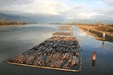
). Barge traffic from logging camps in the upper Pitt basin is a regular sight on the Pitt Lake
Pitt Lake
Pitt Lake is the second-largest lake in the Lower Mainland of British Columbia, being about 53.5 square kilometres in area. It is about 25 km long and about 4.5 km wide at its widest, and is also one of the world's largest tidal lakes, its confluence with the Fraser being only a few miles upstream...
as well as in the area of the two highway bridges and CPR mainline bridge
Canadian Pacific Railway
The Canadian Pacific Railway , formerly also known as CP Rail between 1968 and 1996, is a historic Canadian Class I railway founded in 1881 and now operated by Canadian Pacific Railway Limited, which began operations as legal owner in a corporate restructuring in 2001...
just up from the confluence of the Fraser
Fraser River
The Fraser River is the longest river within British Columbia, Canada, rising at Fraser Pass near Mount Robson in the Rocky Mountains and flowing for , into the Strait of Georgia at the city of Vancouver. It is the tenth longest river in Canada...
.
The Pitt is one of a number of north-south river-lake valleys which join the Fraser along the north side of the lower Fraser. The others are the valleys of the Coquitlam River
Coquitlam River
The Coquitlam River is located in between the cities of Coquitlam and Port Coquitlam, suburban municipalities located in the Metro Vancouver. This river is a tributary for the Fraser River. Each year hundreds of salmon return to spawn in the Coquitlam River. There is a reservoir near the...
, the Alouette River, the Stave River
Stave River
The Stave River is a tributary of the Fraser, joining it at the boundary between the municipalities of Maple Ridge and Mission, about 35 km east of Vancouver, British Columbia, Canada, in the Central Fraser Valley region....
, Suicide Creek (Norrish Creek
Norrish Creek
Norrish Creek is a tributary of the Fraser River. It is located in the Coast Mountains of British Columbia, Canada.- Course :Norrish Creek has its source in Dickson Lake, a medium sized, seldom visited reservoir at the bases of Mount Wardrop and Catherwood. The creek flows alongside Norrish Creek...
), the Chehalis River and, lastly, the valley of Harrison Lake
Harrison Lake
Harrison Lake is the largest lake in the southern Coast Mountains of Canada, being about 250 square kilometres in area. It is about 60 km in length and at its widest almost 9 km across. Its southern end, at the resort community of Harrison Hot Springs, is c. 95 km east of...
, 60 km east of the Pitt.