
Pitt River Bridge
Encyclopedia
The Pitt River Bridge is a cable-stayed bridge
that spans the Pitt River
between Port Coquitlam and Pitt Meadows in British Columbia
, Canada
. The bridge is part of Highway 7, carrying Lougheed Highway across the river. The current bridge opened on October 4, 2009.
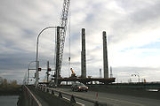
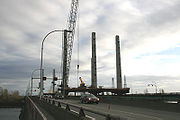 The original bridges were replaced with a cable-stayed bridge and a free-flowing interchange
to replace the Mary-Hill Bypass-Lougheed intersection. On October 4, 2009, four lanes of the new bridge opened to general traffic, soon expanding to three lanes for westbound traffic and four for eastbound traffic. The new span has been engineered to allow for different lane allocations in the future including an eighth lane and possible rapid transit. It also allows for up to 16 meters of vertical clearance for marine traffic. The new bridge structure was built between the two earlier bridges, which were subsequently demolished on November 22nd, 2010.http://www.th.gov.bc.ca/gateway/prb-maryhill/weekly_sched/marineclosure_20101115/notice_to_shipping.pdf
Each of the two spans had two lanes. During the morning and evening commute times, a counterflow lane was opened so that the traffic was three lanes in one direction, one lane in the other.
Cable-stayed bridge
A cable-stayed bridge is a bridge that consists of one or more columns , with cables supporting the bridge deck....
that spans the Pitt River
Pitt River
The Pitt River in British Columbia, Canada is a large tributary of the Fraser River, entering it a few miles upstream from New Westminster and about 25 km ESE of Downtown Vancouver. The river, which begins in the Garibaldi Ranges of the Coast Mountains, is in two sections above and below Pitt...
between Port Coquitlam and Pitt Meadows in British Columbia
British Columbia
British Columbia is the westernmost of Canada's provinces and is known for its natural beauty, as reflected in its Latin motto, Splendor sine occasu . Its name was chosen by Queen Victoria in 1858...
, Canada
Canada
Canada is a North American country consisting of ten provinces and three territories. Located in the northern part of the continent, it extends from the Atlantic Ocean in the east to the Pacific Ocean in the west, and northward into the Arctic Ocean...
. The bridge is part of Highway 7, carrying Lougheed Highway across the river. The current bridge opened on October 4, 2009.
New Bridge and Mary Hill Interchange Project
Interchange (road)
In the field of road transport, an interchange is a road junction that typically uses grade separation, and one or more ramps, to permit traffic on at least one highway to pass through the junction without directly crossing any other traffic stream. It differs from a standard intersection, at which...
to replace the Mary-Hill Bypass-Lougheed intersection. On October 4, 2009, four lanes of the new bridge opened to general traffic, soon expanding to three lanes for westbound traffic and four for eastbound traffic. The new span has been engineered to allow for different lane allocations in the future including an eighth lane and possible rapid transit. It also allows for up to 16 meters of vertical clearance for marine traffic. The new bridge structure was built between the two earlier bridges, which were subsequently demolished on November 22nd, 2010.http://www.th.gov.bc.ca/gateway/prb-maryhill/weekly_sched/marineclosure_20101115/notice_to_shipping.pdf
Original bridge
The original Pitt River Bridge (southern) span opened in 1957 by Premier W. A. C. Bennett. The second (northern) span was built in the 1978. The mid swing span of the south span had the distinction of sometimes not seating properly in the closed position becoming stuck and causing very long traffic line ups (especially before the north span was built), but this problem was fixed many years ago. The control house also operated the lane control system.Each of the two spans had two lanes. During the morning and evening commute times, a counterflow lane was opened so that the traffic was three lanes in one direction, one lane in the other.