
River Ellen
Encyclopedia
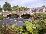
The River Ellen is a river in the English county
of Cumbria
(traditionally in Cumberland
).
 The river rises on the Uldale Fells and runs in a generally western direction, passing Uldale
, Ireby
, Boltongate
, Baggrow
and Blennerhasset parish boundary and Aspatria
.
From there, it continues southwest (instead of more northwesterly) past Oughterside
, Gilcrux
, Bullgill, Crosby
and Dearham
, before flowing into the Solway Firth
at Maryport
.
The river gives its name to the region of Allerdale
.
Tributaries include:
This river has produced pink freshwater pearls since pre-Roman
times.
It passes the boundaries of Netherhall School, Maryport
.
County
A county is a jurisdiction of local government in certain modern nations. Historically in mainland Europe, the original French term, comté, and its equivalents in other languages denoted a jurisdiction under the sovereignty of a count A county is a jurisdiction of local government in certain...
of Cumbria
Cumbria
Cumbria , is a non-metropolitan county in North West England. The county and Cumbria County Council, its local authority, came into existence in 1974 after the passage of the Local Government Act 1972. Cumbria's largest settlement and county town is Carlisle. It consists of six districts, and in...
(traditionally in Cumberland
Cumberland
Cumberland is a historic county of North West England, on the border with Scotland, from the 12th century until 1974. It formed an administrative county from 1889 to 1974 and now forms part of Cumbria....
).
Uldale
Uldale is a small village in Cumbria, England.It is about five miles from Caldbeck, two miles from Ireby with which it forms the civil parish of Ireby and Uldale and Aughertree, 11 miles from Wigton and 12 miles from Cockermouth....
, Ireby
Ireby, Cumbria
Ireby is a village in Cumbria, England, with a population of over 300.Ireby forms part of the civil parish of Ireby and Uldale; for local government purposes it is in the ward of Boltons, under the authority of Allerdale borough council. Historically it was in the county of Cumberland – since...
, Boltongate
Boltongate
Boltongate is a village in Cumbria, England. It is situated about north-east of Cockermouth.All Saints Church, Boltongate has a stone tunnel-vaulted roof said to be the only one of its kind in England. The nearby Rectory incorporates a 15th century pele tower....
, Baggrow
Baggrow
Baggrow is a small village in the parish of Allhallows situated north of the Lake District in the English county of Cumbria. In many parts of the village views of England's 4th highest peak Skiddaw, standing 931 metres above sea level, can be seen to the South East, some 9½ miles...
and Blennerhasset parish boundary and Aspatria
Aspatria
Aspatria is a small town and civil parish in Cumbria, England, and lies half way between Maryport and Wigton, on the A596. Historically within Cumberland, it is about away from the coast. It is approximately seven miles from the northern boundary of the Lake District, and located to the south east...
.
From there, it continues southwest (instead of more northwesterly) past Oughterside
Oughterside
Oughterside is a village in the Allerdale District, in the English county of Cumbria. Nearby settlements include the town of Aspatria and the villages of Hayton and Prospect. For transport there is the A596 road nearby.- References :...
, Gilcrux
Gilcrux
Gilcrux is a populated place and civil parish in West Cumbria, EnglandFormerly part of Cockermouth Rural District Gilcrux is now part of the district of Allerdale.-External links:...
, Bullgill, Crosby
Crosby, Cumbria
Crosby is a small village in Cumbria, England, three miles north-east of Maryport on the A596 road. It has a population of approximately 1000. The local primary school is Crosscanonby St. John's Church of England School. The only remaining public house in the village is The Stag Inn....
and Dearham
Dearham
Dearham is a village and civil parish in the Allerdale district of Cumbria, England. It is situated in West Cumbria, about east of Maryport and west of Cockermouth. According to the 2001 census it had a population of 2,028. It is a large, strung-out village...
, before flowing into the Solway Firth
Solway Firth
The Solway Firth is a firth that forms part of the border between England and Scotland, between Cumbria and Dumfries and Galloway. It stretches from St Bees Head, just south of Whitehaven in Cumbria, to the Mull of Galloway, on the western end of Dumfries and Galloway. The Isle of Man is also very...
at Maryport
Maryport
Maryport is a town and civil parish within the Allerdale borough of Cumbria, England, in the historic county of Cumberland. It is located on the A596 road north of Workington, and is the southernmost town on the Solway Firth. Maryport railway station is on the Cumbrian Coast Line. The town is in...
.
The river gives its name to the region of Allerdale
Allerdale
Allerdale is a non-metropolitan district of Cumbria, England, with borough status. Its council is based in Workington and the borough has a population of 93,492 according to the 2001 census....
.
Tributaries include:
- Dash Beck
- Gill Gooden
This river has produced pink freshwater pearls since pre-Roman
Roman Britain
Roman Britain was the part of the island of Great Britain controlled by the Roman Empire from AD 43 until ca. AD 410.The Romans referred to the imperial province as Britannia, which eventually comprised all of the island of Great Britain south of the fluid frontier with Caledonia...
times.
It passes the boundaries of Netherhall School, Maryport
Netherhall School, Maryport
Netherhall School is a secondary school in Maryport, Cumbria. The school is a registered sports college and has state of the art sports facilities. The school was built in the 1950s and has been open for 60 years...
.