
Goulburn-Oberon Road
Encyclopedia
New South Wales
New South Wales is a state of :Australia, located in the east of the country. It is bordered by Queensland, Victoria and South Australia to the north, south and west respectively. To the east, the state is bordered by the Tasman Sea, which forms part of the Pacific Ocean. New South Wales...
country road linking Goulburn
Goulburn, New South Wales
Goulburn is a provincial city in the Southern Tablelands of New South Wales, Australia in Goulburn Mulwaree Council Local Government Area. It is located south-west of Sydney on the Hume Highway and above sea-level. On Census night 2006, Goulburn had a population of 20,127 people...
near the Hume Highway
Hume Highway
The Hume Highway/Hume Freeway is one of Australia's major inter-city highways, running for 880 km between Sydney and Melbourne. It is part of the Auslink National Network and is a vital link for road freight to transport goods to and from the two cities as well as serving Albury-Wodonga and...
to Oberon
Oberon, New South Wales
-See also:*Oberon Correctional Centre*Mount Trickett*Mount Bindo*Shooters Hill-External links:***...
. The road is designated as Main Road 256 and is "seen as a future bypass of Sydney
Sydney
Sydney is the most populous city in Australia and the state capital of New South Wales. Sydney is located on Australia's south-east coast of the Tasman Sea. As of June 2010, the greater metropolitan area had an approximate population of 4.6 million people...
".
At its northern end, the road passes through imposing plantations of radiata pine trees that supply the timber complex of Oberon.
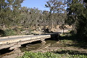
It is now fully sealed, having undergone extensive work between 2002 and 2008. The final section of around 5 km long, located between the Abercrombie River
Abercrombie River
The Abercrombie River is a river in New South Wales, Australia, flowing from Mount Werong westward to the Wyangala Dam near Cowra. The river is a tributary of the Lachlan, which it joins at Wyangala lake....
and the end of Wombeyan Caves Road
Wombeyan Caves Road
The Wombeyan Caves Road is a New South Wales country road linking Mittagong near the Hume Highway in the east to the Goulburn-Oberon Road at the locality of Richlands in the west. The road is designated as Main Road 258.-Route:...
was sealed in February 2008. In 2007 the Upper Lachlan Shire received a grant of $710,000 over 3 years from the New South Wales Government to cover one third of the cost of realigning and sealing that remaining section and will allocate $1,420,000 of council funds over those three years to complete the work. With the support of Oberon Council the work was completed in the first year.
In conjunction with O'Connell Road
O'Connell Road
O'Connell Road is a New South Wales rural road linking Oberon to the regional highway hub of Bathurst, where several roads including the Great Western Highway, Mid-Western Highway, Mitchell Highway and Bathurst-Ilford Road join...
from Oberon to Bathurst
Bathurst, New South Wales
-CBD and suburbs:Bathurst's CBD is located on William, George, Howick, Russell, and Durham Streets. The CBD is approximately 25 hectares and surrounds two city blocks. Within this block layout is banking, government services, shopping centres, retail shops, a park* and monuments...
, this scenic route provides a leisurely and surprisingly direct route between Bathurst and Goulburn. The descent into the Abercrombie River Gorge from the North is particularly scenic.
The Wombeyan Caves Road
Wombeyan Caves Road
The Wombeyan Caves Road is a New South Wales country road linking Mittagong near the Hume Highway in the east to the Goulburn-Oberon Road at the locality of Richlands in the west. The road is designated as Main Road 258.-Route:...
, leading through the Wombeyan Caves reserve and on to Mittagong
Mittagong, New South Wales
Mittagong is a town located in the Southern Highlands of New South Wales, Australia, in Wingecarribee Shire. At the 2006 census, Mittagong had a population of 7,460 people. The town can be seen as the gateway to the Southern Highlands when coming from Sydney. The town is close to Bowral, Berrima,...
starts at the locality of Richlands, around half way between Goulburn and Oberon. The Laggan-Taralga Road from Crookwell
Crookwell, New South Wales
Crookwell is a small town located in the Southern Tablelands of New South Wales, Australia, in the Upper Lachlan Shire. At the 2006 census, Crookwell had a population of 1,993 people. The town is at a relatively high altitude in Australian terms , and there are occasional snowfalls during the...
ends in the historic town of Taralga
Taralga, New South Wales
Taralga is a small village in the Southern Tablelands of New South Wales, Australia in Upper Lachlan Shire. It is located at the intersection of the Goulburn-Oberon Road and the Laggan-Taralga Road. It is accessible from Oberon to the north, Mittagong to the east, Goulburn to the south, and...
a little further south. The Bannaby road to the locality of Bannaby
Bannaby, New South Wales
Bannaby is a locality in the Southern Tablelands of New South Wales, Australia in Upper Lachlan Shire. It is located near the township of Taralga, on the Bannaby road. The locality consists of an Anglican Church and some woolsheds....
also starts in Taralga.
List of towns, villages and localities on the Goulburn to Oberon Road
- GoulburnGoulburn, New South WalesGoulburn is a provincial city in the Southern Tablelands of New South Wales, Australia in Goulburn Mulwaree Council Local Government Area. It is located south-west of Sydney on the Hume Highway and above sea-level. On Census night 2006, Goulburn had a population of 20,127 people...
- Tarlo
- Myrtleville
- TaralgaTaralga, New South WalesTaralga is a small village in the Southern Tablelands of New South Wales, Australia in Upper Lachlan Shire. It is located at the intersection of the Goulburn-Oberon Road and the Laggan-Taralga Road. It is accessible from Oberon to the north, Mittagong to the east, Goulburn to the south, and...
- Richlands
- Porters Retreat
- Black Springs
- OberonOberon, New South Wales-See also:*Oberon Correctional Centre*Mount Trickett*Mount Bindo*Shooters Hill-External links:***...