
Wombeyan Caves Road
Encyclopedia

New South Wales
New South Wales is a state of :Australia, located in the east of the country. It is bordered by Queensland, Victoria and South Australia to the north, south and west respectively. To the east, the state is bordered by the Tasman Sea, which forms part of the Pacific Ocean. New South Wales...
country road linking Mittagong
Mittagong, New South Wales
Mittagong is a town located in the Southern Highlands of New South Wales, Australia, in Wingecarribee Shire. At the 2006 census, Mittagong had a population of 7,460 people. The town can be seen as the gateway to the Southern Highlands when coming from Sydney. The town is close to Bowral, Berrima,...
near the Hume Highway
Hume Highway
The Hume Highway/Hume Freeway is one of Australia's major inter-city highways, running for 880 km between Sydney and Melbourne. It is part of the Auslink National Network and is a vital link for road freight to transport goods to and from the two cities as well as serving Albury-Wodonga and...
in the east to the Goulburn-Oberon Road
Goulburn-Oberon Road
The Goulburn to Oberon Road is a New South Wales country road linking Goulburn near the Hume Highway to Oberon. The road is designated as Main Road 256 and is "seen as a future bypass of Sydney"....
at the locality of Richlands in the west. The road is designated as Main Road 258.
Route
At its eastern end, the road starts at the Old Hume Highway just west of Mittagong. Access from the north of Mittagong is via Mittagong, while access from the south is via the half interchange at the southern end of the Mittagong Bypass section of the Hume Highway. It passes through farmland and the locality of High RangeHigh Range, New South Wales
High Range is a village located in the Southern Highlands of New South Wales, Australia near Bowral and Mittagong. The village is centred just off the Wombeyan Caves Road 55 km east of the Wombeyan Caves...
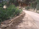
as a sealed road. Further west, it changes to unsealed and continues through farmland before entering the Wombeyan Caves area. The road conditions deteriorate substantially as the road goes further west until it reaches the main Wombeyan Caves reserve camping area. West of the camping area, the road is sealed as it climbs a tight, winding section up the mountain side. At the top of that hill, the road reverts to unsealed but is wider and straighter. Close to its western end, the road is a reasonable standard sealed road.
History
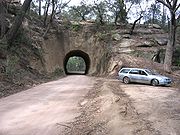
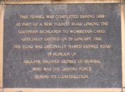
The road passes through a historical single lane tunnel carved through the sandstone ridge in a forest area part way through the farmland section. The tunnel is around 22 m long at ground level, but has a sandstone outcrop extending several metres further at its western end.The plaque at the eastern end of the tunnel states:
"This tunnel was completed during 1899 as part of a new tourist road linking the southern highlands to Wombeyan Caves. Officially opened on 29 January 1900, the road was originally named Duprez Road in honour of Adolphe Prosper Duprez of Bowral who was the driving force behind its construction."
Road conditions
Due to the extremely poor condition of the road for several kilometres east of the Wombeyan Caves camping area, it is strongly recommended to access the caves reserve from the Goulburn-Oberon Road. Regardless of the impression that might be given by road maps, the road should not be considered to be a through road unless you are in a 4WD or have a lot of time. The Hume HighwayHume Highway
The Hume Highway/Hume Freeway is one of Australia's major inter-city highways, running for 880 km between Sydney and Melbourne. It is part of the Auslink National Network and is a vital link for road freight to transport goods to and from the two cities as well as serving Albury-Wodonga and...
and Goulburn-Oberon Road
Goulburn-Oberon Road
The Goulburn to Oberon Road is a New South Wales country road linking Goulburn near the Hume Highway to Oberon. The road is designated as Main Road 256 and is "seen as a future bypass of Sydney"....
via Goulburn are a better option if you are not aiming to get to somewhere between the Wombeyan Caves camping area and the sandstone tunnel west of High Range.
Towns
- Wombeyan Caves
- MittagongMittagong, New South WalesMittagong is a town located in the Southern Highlands of New South Wales, Australia, in Wingecarribee Shire. At the 2006 census, Mittagong had a population of 7,460 people. The town can be seen as the gateway to the Southern Highlands when coming from Sydney. The town is close to Bowral, Berrima,...
- BowralBowral, New South Wales-Attractions:Bowral is perhaps the best known of the towns and villages of the Southern Highlands, and in recent years has become the commercial centre of the Wingecarribee Shire. Bowral is known for its boutiques, antique stores, gourmet restaurants, and rich coffee culture.Bowral is home to the...
- JoadjaJoadja, New South WalesJoadja is a ghost town in the Southern Highlands of New South Wales, Australia, in Wingecarribee Shire.It was a thriving mining town between 1870–1911. It was home for approximately 1100 people, many of Scots ancestry, and was connected to the nearby town of Mittagong by a narrow gauge railway that...
- High RangeHigh Range, New South WalesHigh Range is a village located in the Southern Highlands of New South Wales, Australia near Bowral and Mittagong. The village is centred just off the Wombeyan Caves Road 55 km east of the Wombeyan Caves...
- Richlands
- TaralgaTaralga, New South WalesTaralga is a small village in the Southern Tablelands of New South Wales, Australia in Upper Lachlan Shire. It is located at the intersection of the Goulburn-Oberon Road and the Laggan-Taralga Road. It is accessible from Oberon to the north, Mittagong to the east, Goulburn to the south, and...
See also
- Highways in AustraliaHighways in AustraliaThis is a list of highways in Australia, listed alphabetically along with each highway's route number and location. Note that some highways service more than one state or territory.-Route numbering systems:...
- List of highways in New South Wales