
Taralga, New South Wales
Encyclopedia
Taralga is a small village in the Southern Tablelands
of New South Wales
, Australia
in Upper Lachlan Shire. It is located at the intersection of the Goulburn-Oberon Road
and the Laggan-Taralga Road. It is accessible from Oberon
to the north, Mittagong
to the east, Goulburn
to the south, and Crookwell
to the west. At the 2006 census
, Taralga had a population of 812 people.
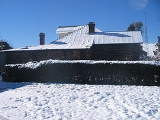
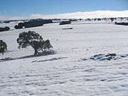
Taralga is located relatively close to the famous Wombeyan Caves. It is a very cold area and is frequently affected by snow in the winter months.
The population of Taralga has fluctuated over time - from 100 or so in 1863, to over 700 thirty years later, followed by a decline to half that size immediately after the depression of the 1890s. By the mid 1950s it had regained almost its largest size, but today houses around 400 people.
seems to have been in the 1830s after which they are not recorded by European history. Accordingly, they would have been pushed further west to less fertile plains after the disease brought by the Europeans. Tales of giving poisoned bread to Aborigines by settlers are also founded to be from this region.
Charles Throsby
passed through Taralga in 1819 journeyed from Cowpastures to Bathurst
in search of new grazing lands. By 1824, John Macarthur
's son James and his nephew Hannibal had established themselves in the Taralga region where they helped pioneer Australia's wool industry. A private village was established on land donated by James Macarthur and cleared by convicts in order to house and service members of the Macarthur family and their employees. The town's main street, Orchard Street, is located on the site of Macarthur's orchard.
An 1828 census revealed a small number of residents at Taralga suggesting the village was already under way by that time, although there were probably no more than a few buildings.
For the first few decades of being colonised, most of the settlers were convicts assigned to the landowners and it was they who largely cleared the land, built the huts and houses, and ran the farms. Taralga started to look like a town after the first few houses were built in the 1840s.
Taralga was officially established as a town in the 1860s, with a school in 1857, and churches—Presbyterian in 1861, St. Ignatius Roman Catholic in 1864, St. Lukes Anglican
in 1866 and Methodist (now the Historical Society building) in 1868. There were a number of stores, smiths and artisans' businesses and two hotels recorded in 1866. There was a large increase in population in Taralga after the 1860s, caused mainly by the gold rush
bringing new migrants to the area.
A railway to Taralga opened in 1926 and closed in 1957. It branched from the Crookwell line
at the locality of Roslyn. The line has been lifted and little remains of the formation.
 While the population of Taralga declined after the gold rush period, the charm and character of the town certainly did not. Today there are many historically significant buildings to be observed throughout the town. Small vineyards and beautiful countryside can be found in and around the town. There are two heritage listed hotels if one becomes parched, or the sports club with lawn bowling greens and tennis courts. The town also hosts the annual "Australia Day Rodeo" and the Taralga Tigers Rugby Club always attracts big crowds during the Winter months and in the summer touch football is a must do and see.
Southern Tablelands
The Southern Tablelands is a geographic area of the State of New South Wales, Australia. This area is located west of the Great Dividing Range.The area is characterised by flat country which has generally been extensively cleared and used for grazing purposes...
of New South Wales
New South Wales
New South Wales is a state of :Australia, located in the east of the country. It is bordered by Queensland, Victoria and South Australia to the north, south and west respectively. To the east, the state is bordered by the Tasman Sea, which forms part of the Pacific Ocean. New South Wales...
, Australia
Australia
Australia , officially the Commonwealth of Australia, is a country in the Southern Hemisphere comprising the mainland of the Australian continent, the island of Tasmania, and numerous smaller islands in the Indian and Pacific Oceans. It is the world's sixth-largest country by total area...
in Upper Lachlan Shire. It is located at the intersection of the Goulburn-Oberon Road
Goulburn-Oberon Road
The Goulburn to Oberon Road is a New South Wales country road linking Goulburn near the Hume Highway to Oberon. The road is designated as Main Road 256 and is "seen as a future bypass of Sydney"....
and the Laggan-Taralga Road. It is accessible from Oberon
Oberon, New South Wales
-See also:*Oberon Correctional Centre*Mount Trickett*Mount Bindo*Shooters Hill-External links:***...
to the north, Mittagong
Mittagong, New South Wales
Mittagong is a town located in the Southern Highlands of New South Wales, Australia, in Wingecarribee Shire. At the 2006 census, Mittagong had a population of 7,460 people. The town can be seen as the gateway to the Southern Highlands when coming from Sydney. The town is close to Bowral, Berrima,...
to the east, Goulburn
Goulburn, New South Wales
Goulburn is a provincial city in the Southern Tablelands of New South Wales, Australia in Goulburn Mulwaree Council Local Government Area. It is located south-west of Sydney on the Hume Highway and above sea-level. On Census night 2006, Goulburn had a population of 20,127 people...
to the south, and Crookwell
Crookwell, New South Wales
Crookwell is a small town located in the Southern Tablelands of New South Wales, Australia, in the Upper Lachlan Shire. At the 2006 census, Crookwell had a population of 1,993 people. The town is at a relatively high altitude in Australian terms , and there are occasional snowfalls during the...
to the west. At the 2006 census
Census in Australia
The Australian census is administered once every five years by the Australian Bureau of Statistics. The most recent census was conducted on 9 August 2011; the next will be conducted in 2016. Prior to the introduction of regular censuses in 1961, they had also been run in 1901, 1911, 1921, 1933,...
, Taralga had a population of 812 people.
Taralga is located relatively close to the famous Wombeyan Caves. It is a very cold area and is frequently affected by snow in the winter months.
The population of Taralga has fluctuated over time - from 100 or so in 1863, to over 700 thirty years later, followed by a decline to half that size immediately after the depression of the 1890s. By the mid 1950s it had regained almost its largest size, but today houses around 400 people.
History
The area around Taralga was the traditional land of the Burra Burra peoples, a warlike tribe who often clashed with neighbouring tribes and never lost a fight. Although no major clashes with the Europeans seem to have been recorded, nor tales of collaboration with them, their last great gathering or corroboreeCorroboree
A corroboree is a ceremonial meeting of Australian Aborigines. The word was coined by the European settlers of Australia in imitation of the Aboriginal word caribberie. At a corroboree Aborigines interact with the Dreamtime through dance, music and costume. Many ceremonies act out events from the...
seems to have been in the 1830s after which they are not recorded by European history. Accordingly, they would have been pushed further west to less fertile plains after the disease brought by the Europeans. Tales of giving poisoned bread to Aborigines by settlers are also founded to be from this region.
Charles Throsby
Charles Throsby
Charles Throsby was an Australian explorer, pioneer and parliamentarian. He opened up much new land beyond the Blue Mountains for colonial settlement. He was a grazier, and became a prominent member of New South Wales society.- Early life :...
passed through Taralga in 1819 journeyed from Cowpastures to Bathurst
Bathurst, New South Wales
-CBD and suburbs:Bathurst's CBD is located on William, George, Howick, Russell, and Durham Streets. The CBD is approximately 25 hectares and surrounds two city blocks. Within this block layout is banking, government services, shopping centres, retail shops, a park* and monuments...
in search of new grazing lands. By 1824, John Macarthur
John MacArthur
John MacArthur may refer to:* John Macarthur , Australian wool industry pioneer and Rum Rebel* John McArthur, Jr. , American architect* John McArthur , Union general during the American Civil War...
's son James and his nephew Hannibal had established themselves in the Taralga region where they helped pioneer Australia's wool industry. A private village was established on land donated by James Macarthur and cleared by convicts in order to house and service members of the Macarthur family and their employees. The town's main street, Orchard Street, is located on the site of Macarthur's orchard.
An 1828 census revealed a small number of residents at Taralga suggesting the village was already under way by that time, although there were probably no more than a few buildings.
For the first few decades of being colonised, most of the settlers were convicts assigned to the landowners and it was they who largely cleared the land, built the huts and houses, and ran the farms. Taralga started to look like a town after the first few houses were built in the 1840s.
Taralga was officially established as a town in the 1860s, with a school in 1857, and churches—Presbyterian in 1861, St. Ignatius Roman Catholic in 1864, St. Lukes Anglican
Anglican Church of Australia
The Anglican Church of Australia is a member church of the Anglican Communion. It was previously officially known as the Church of England in Australia and Tasmania...
in 1866 and Methodist (now the Historical Society building) in 1868. There were a number of stores, smiths and artisans' businesses and two hotels recorded in 1866. There was a large increase in population in Taralga after the 1860s, caused mainly by the gold rush
Gold rush
A gold rush is a period of feverish migration of workers to an area that has had a dramatic discovery of gold. Major gold rushes took place in the 19th century in Australia, Brazil, Canada, South Africa, and the United States, while smaller gold rushes took place elsewhere.In the 19th and early...
bringing new migrants to the area.
A railway to Taralga opened in 1926 and closed in 1957. It branched from the Crookwell line
Crookwell railway line, New South Wales
The Crookwell railway line is a disused branch railway line in the south of New South Wales, Australia. It has never officially been closed. It branched from the Main South line at North Goulburn and passed north through the localities of Kenmore and Roslyn to the town of Crookwell.-History:The...
at the locality of Roslyn. The line has been lifted and little remains of the formation.
Taralga Today
See also
- BannabyBannaby, New South WalesBannaby is a locality in the Southern Tablelands of New South Wales, Australia in Upper Lachlan Shire. It is located near the township of Taralga, on the Bannaby road. The locality consists of an Anglican Church and some woolsheds....
- Wombeyan Caves
- CrookwellCrookwell, New South WalesCrookwell is a small town located in the Southern Tablelands of New South Wales, Australia, in the Upper Lachlan Shire. At the 2006 census, Crookwell had a population of 1,993 people. The town is at a relatively high altitude in Australian terms , and there are occasional snowfalls during the...
- GoulburnGoulburn, New South WalesGoulburn is a provincial city in the Southern Tablelands of New South Wales, Australia in Goulburn Mulwaree Council Local Government Area. It is located south-west of Sydney on the Hume Highway and above sea-level. On Census night 2006, Goulburn had a population of 20,127 people...