
Glassell Park, Los Angeles, California
Encyclopedia
Glassell Park is a neighborhood in northeast Los Angeles
, California
.
and the Los Angeles River
on the west, the city of Glendale
on the northwest, Eagle Rock
on the northeast, Mount Washington on the southeast and Cypress Park
on the south. The district's boundaries are roughly the city of Glendale
on the north, the Los Angeles River on the west, Division Street on the southeast, El Paso Drive and York Boulevard on the northeast.
The neighborhood is split between Los Angeles City Council District 13 and District 14
, with a small portion in District 1. It is part of California's 31st congressional district
, lies within zip code
90065, and the area code is 323
.
The neighborhood is located in a relatively hilly region of Los Angeles. While the hills often provide spectacular views, they can also become unstable, as happened during the unusually wet 2004-05 rainy season, during which hillsides slid down and destroyed several houses. Like many hillside areas in Southern California
, hillside areas of Glassell Park are susceptible to wildfires, leading the LAFD
to impose parking restrictions on certain streets during high-fire-danger "red flag
" days.
, thoroughfares running through Glassell Park provide relatively easy access to most parts of Los Angeles, including the San Fernando Valley
and San Gabriel Valley
. The Glendale Freeway runs through the neighborhood, connecting with the Ventura Freeway
to the north and with the Golden State Freeway to the south and terminating shortly thereafter at Glendale Boulevard. Plans had originally called for the freeway to extend to Santa Monica
. Major arterial streets include Eagle Rock Boulevard and San Fernando Road
. Glassell Park also has a designated bike lane along Eagle Rock Blvd. south of York. There is a movement to connect these bike paths with a larger grid.
, granted in 1784 to Spanish army corporal José María Verdugo
. Attorney Andrew Glassell
received part of Rancho San Rafael from the lawsuit known as the Great Partition of 1871. Glassell eventually settled in the area with his family, for whom many streets, including Toland Way, Drew, Andrita and Marguarite Streets are named.
The development of Glassell Park began in the early 20th Century, as subdivisions between Verdugo and San Fernando Roads began to be sold in 1907. In 1912, the city of Los Angeles annexed most of Glassell Park, annexing the remainder in 1916. The Glassell family continued to subdivide their land, selling off what is now Forest Lawn Memorial Park
during the Great Depression
. The growing neighborhood was served by a line of the Los Angeles Railway
, which traveled in the median of Eagle Rock Boulevard towards Eagle Rock. Today, Glassell Park is rediscovering its history from the Verdugo era. Glassell Park also hosts the historical road of trade between the Verdugo Rancho and the fledging Pueblo of Los Angeles. This road is called Verdugo Road, which historically met up with San Fernando Road.
that began in the early 2000s. An influx of middle-class families have moved into the neighborhood, attracted by the abundance of Craftsman
homes and relatively low prices. Despite such gentrification
, sections of Glassell Park, however, have remained plagued by gang-related crime and violence.
Near the center of Glassell Park, on Verdugo Road, is the Glassell Park Recreation Center. Along San Fernando Road and adjacent to the L.A. River is the Rio de Los Angeles State Park, built on part of the Taylor Yard railway switching facility.
 The Los Angeles Unified School District
operates two public elementary schools and one middle school in Glassell Park:
The following private school
s are located in Glassell Park:
Glassell Park is home to three charter schools:
Library services are provided by Los Angeles Public Library
branch libraries in adjacent neighborhoods:
Los Angeles, California
Los Angeles , with a population at the 2010 United States Census of 3,792,621, is the most populous city in California, USA and the second most populous in the United States, after New York City. It has an area of , and is located in Southern California...
, California
California
California is a state located on the West Coast of the United States. It is by far the most populous U.S. state, and the third-largest by land area...
.
Geography
Glassell Park borders Atwater VillageAtwater Village, Los Angeles, California
Atwater Village is a neighborhood in northeast Los Angeles, California. It lies at an elevation of 404 feet .-Geography:Atwater Village lies between the Los Angeles River to the west and Glendale to the north and east...
and the Los Angeles River
Los Angeles River
The Los Angeles River is a river that starts in the San Fernando Valley, in the Simi Hills and Santa Susana Mountains, and flows through Los Angeles County, California, from Canoga Park in the western end of the San Fernando Valley, nearly southeast to its mouth in Long Beach...
on the west, the city of Glendale
Glendale, California
Glendale is a city in Los Angeles County, California, United States. As of the 2010 Census, the city population is 191,719, down from 194,973 at the 2000 census. making it the third largest city in Los Angeles County and the 22nd largest city in the state of California...
on the northwest, Eagle Rock
Eagle Rock, Los Angeles, California
In 1909, Hill Avenue, now Hill Drive, was one of Eagle Rock's most beautiful streets. Other streets were Royal Drive , Acacia Street , Kenilworth Avenue , Highland Avenue , and Fairmont Avenue...
on the northeast, Mount Washington on the southeast and Cypress Park
Cypress Park, Los Angeles, California
Cypress Park is a neighborhood in Northeast Los Angeles. It is located at the confluence of the Los Angeles River and Arroyo Seco and is less than 2.5 miles north of Downtown Los Angeles...
on the south. The district's boundaries are roughly the city of Glendale
Glendale, California
Glendale is a city in Los Angeles County, California, United States. As of the 2010 Census, the city population is 191,719, down from 194,973 at the 2000 census. making it the third largest city in Los Angeles County and the 22nd largest city in the state of California...
on the north, the Los Angeles River on the west, Division Street on the southeast, El Paso Drive and York Boulevard on the northeast.
The neighborhood is split between Los Angeles City Council District 13 and District 14
Los Angeles City Council District 14
Los Angeles City Council District 14 is one of the 15 districts of the Los Angeles City Council. It is a primarily Latino district in Boyle Heights and Northeast Los Angeles...
, with a small portion in District 1. It is part of California's 31st congressional district
California's 31st congressional district
California's 31st congressional district is a congressional district in the U.S. state of California based in Los Angeles County. It is currently the only congressional district entirely based within the city of Los Angeles and includes the heavily Hispanic/Latino portions of inner-city Los...
, lies within zip code
ZIP Code
ZIP codes are a system of postal codes used by the United States Postal Service since 1963. The term ZIP, an acronym for Zone Improvement Plan, is properly written in capital letters and was chosen to suggest that the mail travels more efficiently, and therefore more quickly, when senders use the...
90065, and the area code is 323
Area code 323
North American area code 323 is a California telephone area code which covers, roughly, the area of central Los Angeles . 323 also includes several gateway cities of the region, including Bell and Huntington Park...
.
The neighborhood is located in a relatively hilly region of Los Angeles. While the hills often provide spectacular views, they can also become unstable, as happened during the unusually wet 2004-05 rainy season, during which hillsides slid down and destroyed several houses. Like many hillside areas in Southern California
Southern California
Southern California is a megaregion, or megapolitan area, in the southern area of the U.S. state of California. Large urban areas include Greater Los Angeles and Greater San Diego. The urban area stretches along the coast from Ventura through the Southland and Inland Empire to San Diego...
, hillside areas of Glassell Park are susceptible to wildfires, leading the LAFD
Los Angeles Fire Department
The Los Angeles Fire Department is the agency that provides fire protection and emergency medical services for the city of Los Angeles....
to impose parking restrictions on certain streets during high-fire-danger "red flag
Red flag warning
A Red Flag Warning is a forecast warning issued by the United States National Weather Service to inform area firefighting and land management agencies that conditions are ideal for wildland fire ignition and propagation...
" days.
Transportation
Located 5 miles north of Downtown Los AngelesDowntown Los Angeles
Downtown Los Angeles is the central business district of Los Angeles, California, United States, located close to the geographic center of the metropolitan area...
, thoroughfares running through Glassell Park provide relatively easy access to most parts of Los Angeles, including the San Fernando Valley
San Fernando Valley
The San Fernando Valley is an urbanized valley located in the Los Angeles metropolitan area of southern California, United States, defined by the dramatic mountains of the Transverse Ranges circling it...
and San Gabriel Valley
San Gabriel Valley
The San Gabriel Valley is one of the principal valleys of Southern California, United States. It lies to the east of Los Angeles, to the north of the Puente Hills, to the south of the San Gabriel Mountains, and west of the Inland Empire. It derives its name from the San Gabriel River that flows...
. The Glendale Freeway runs through the neighborhood, connecting with the Ventura Freeway
Ventura Freeway
The Ventura Freeway is a freeway in southern California running from Ventura to Pasadena. It is the principal east-west route through Ventura County and in the southern San Fernando Valley in Los Angeles County. From Ventura to its intersection with the Hollywood Freeway in the southeastern San...
to the north and with the Golden State Freeway to the south and terminating shortly thereafter at Glendale Boulevard. Plans had originally called for the freeway to extend to Santa Monica
Santa Monica, California
Santa Monica is a beachfront city in western Los Angeles County, California, US. Situated on Santa Monica Bay, it is surrounded on three sides by the city of Los Angeles — Pacific Palisades on the northwest, Brentwood on the north, West Los Angeles on the northeast, Mar Vista on the east, and...
. Major arterial streets include Eagle Rock Boulevard and San Fernando Road
San Fernando Road
San Fernando Road is a major street in the city and county of Los Angeles. It starts off in Castaic as The Old Road, passing through Santa Clarita and the Newhall Pass, whereupon its intersection with Sierra Highway near the junction of the Golden State and the Antelope Valley Freeways, it...
. Glassell Park also has a designated bike lane along Eagle Rock Blvd. south of York. There is a movement to connect these bike paths with a larger grid.
History
The land that would later become Glassell Park was originally part of Rancho San RafaelRancho San Rafael
Rancho San Rafael was a Spanish land grant bordering the Los Angeles River and the Arroyo Seco in present day Los Angeles County, California, given in 1784 to Jose Maria Verdugo. The rancho includes the present day cities of Glendale, Eagle Rock, La Cañada, Montrose, and Verdugo City...
, granted in 1784 to Spanish army corporal José María Verdugo
Jose Maria Verdugo
José María Verdugo was a soldier from the Presidio of San Diego who was assigned to the Mission San Gabriel Arcángel at the time his land was granted by the Spanish Empire in 1784.-Spanish soldier:...
. Attorney Andrew Glassell
Andrew Glassell
Andrew Glassell was a Los Angeles real estate attorney and investor. He may be best known as one of the founders of the city of Orange, California.-Early life and career:...
received part of Rancho San Rafael from the lawsuit known as the Great Partition of 1871. Glassell eventually settled in the area with his family, for whom many streets, including Toland Way, Drew, Andrita and Marguarite Streets are named.
The development of Glassell Park began in the early 20th Century, as subdivisions between Verdugo and San Fernando Roads began to be sold in 1907. In 1912, the city of Los Angeles annexed most of Glassell Park, annexing the remainder in 1916. The Glassell family continued to subdivide their land, selling off what is now Forest Lawn Memorial Park
Forest Lawn Memorial Park, Glendale
Forest Lawn Memorial Park is a privately owned cemetery in Glendale, California. It is the original location of Forest Lawn, a chain of cemeteries in Southern California. The land was formerly part of Providencia Ranch.-History:...
during the Great Depression
Great Depression
The Great Depression was a severe worldwide economic depression in the decade preceding World War II. The timing of the Great Depression varied across nations, but in most countries it started in about 1929 and lasted until the late 1930s or early 1940s...
. The growing neighborhood was served by a line of the Los Angeles Railway
Los Angeles Railway
The Los Angeles Railway was a system of streetcars that operated in central Los Angeles, California and the immediate surrounding neighborhoods between from 1901 and 1963. Except for two short funicular railways it operated on tracks...
, which traveled in the median of Eagle Rock Boulevard towards Eagle Rock. Today, Glassell Park is rediscovering its history from the Verdugo era. Glassell Park also hosts the historical road of trade between the Verdugo Rancho and the fledging Pueblo of Los Angeles. This road is called Verdugo Road, which historically met up with San Fernando Road.
The neighborhood
Today Glassell Park is largely working class, Latino, White, and Filipino. The neighborhood has been significantly affected by the Southern California real estate boomUnited States housing bubble
The United States housing bubble is an economic bubble affecting many parts of the United States housing market in over half of American states. Housing prices peaked in early 2006, started to decline in 2006 and 2007, and may not yet have hit bottom as of 2011. On December 30, 2008 the...
that began in the early 2000s. An influx of middle-class families have moved into the neighborhood, attracted by the abundance of Craftsman
Arts and crafts
Arts and crafts comprise a whole host of activities and hobbies that are related to making things with one's hands and skill. These can be sub-divided into handicrafts or "traditional crafts" and "the rest"...
homes and relatively low prices. Despite such gentrification
Gentrification
Gentrification and urban gentrification refer to the changes that result when wealthier people acquire or rent property in low income and working class communities. Urban gentrification is associated with movement. Consequent to gentrification, the average income increases and average family size...
, sections of Glassell Park, however, have remained plagued by gang-related crime and violence.
Near the center of Glassell Park, on Verdugo Road, is the Glassell Park Recreation Center. Along San Fernando Road and adjacent to the L.A. River is the Rio de Los Angeles State Park, built on part of the Taylor Yard railway switching facility.
Education
Los Angeles Unified School District
Los Angeles Unified School District is the largest public school system in California. It is the 2nd largest public school district in the United States. Only the New York City Department of Education has a larger student population...
operates two public elementary schools and one middle school in Glassell Park:
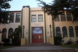
- Glassell Park Elementary SchoolGlassell Park Elementary SchoolGlassell Park Elementary School is an elementary school listed on the National Register of Historic Places.It is located at 2211 W. Avenue 30, in the Glassell Park neighborhood of Los Angeles, California. It is a PK-6 active school. The principal is Mr...
, which was added to the National Register of Historic PlacesNational Register of Historic PlacesThe National Register of Historic Places is the United States government's official list of districts, sites, buildings, structures, and objects deemed worthy of preservation...
in April 2007 - Fletcher Drive Elementary School
- Washington Irving Middle School
The following private school
Private school
Private schools, also known as independent schools or nonstate schools, are not administered by local, state or national governments; thus, they retain the right to select their students and are funded in whole or in part by charging their students' tuition, rather than relying on mandatory...
s are located in Glassell Park:
- Ribét Academy
- St. Bernard (CatholicCatholic schoolCatholic schools are maintained parochial schools or education ministries of the Catholic Church. the Church operates the world's largest non-governmental school system...
) School
Glassell Park is home to three charter schools:
- Celerity Octavia Charter School (K-6)
- Santa Rosa Charter Academy (SRCA)
- Los Feliz Charter School for the Arts (LFCSA) Charter Elementary School
Library services are provided by Los Angeles Public Library
Los Angeles Public Library
The Los Angeles Public Library system serves the residents of Los Angeles, California, United States. With over 6 million volumes, LAPL is one of the largest publicly funded library systems in the world. The system is overseen by a Board of Library Commissioners with five members appointed by the...
branch libraries in adjacent neighborhoods:
- Atwater Village branch, 3379 Glendale Boulevard
- Cypress Park branch, 1150 Cypress Avenue
- Eagle Rock branch 5027 Caspar Avenue
Notable residents
- Edward L. ThrasherEdward L. ThrasherEdward Lee Thrasher , who went by Edward L. Thrasher, was a builder, contractor and decorator who served on the Los Angeles, California, City Council between 1931 and 1942.-Biography:...
, builder, contractor and decorator who served on the Los Angeles City Council between 1931 and 1942