
Ghum, West Bengal
Encyclopedia
Ghum is a small hilly locality in the Darjeeling Himalayan hill region
of West Bengal
, India
. Ghum railway station of the Darjeeling Himalayan Railway
is the highest railway station in India. It is situated at an altitude of 2,225.7 m (7,407 ft). The place is the home of the Ghum Monastery and the Batasia Loop
, a bend of the Darjeeling Himalayan railway.
via Sonada
. Kalimpong is about 45 km away via Lopchu. Another road leads to Mongpu and then on to the Kalimpong-Siliguri road. There is a road to Kurseong via Dow Hill. Sukhiapokhri
, almost on the India-Nepal border, is 11 km on the road to Mirik
.
Construction of the Darjeeling Himalayan Railway started in 1879 and the railway track reached Ghum on 4 April 1881. Until 1878, the journey from Kolkata to Darjeeling took 5-6 days – using steam-engine-pulled trains, crossing the Ganges by steam ferry at Sahebganj, and then using bullock carts and palanquins. In 1878, Siliguri was put on the railway map of India, cutting down the journey to two days. In 2007, the train journey from Kolkata to New Jalpaiguri (a new railway station 6 km from Siliguri) takes about 10 hours. Thereafter it is 3-4 hours to Ghum or Darjeeling by road or 6-7 hours by the Darjeeling Himalayan Railway. Those who are not eager to travel all the way from New Jalpaiguri to Darjeeling by the slow train climbing up the hill can enjoy a ride on the tourist train from Darjeeling to Ghum and back.
After climbing from Siliguri to Ghum, the train starts descending about 182.9 m (1,000 ft) to Darjeeling, first crossing the graceful double loop at Batasia (meaning windy place).
Ghum is claimed by some tourist literature to be the highest railway station in the world. In this context, it may be noted that the Qingzang railway
in China, connecting Xining
, Qinghai Province
, to Lhasa
, Tibet Autonomous Region
, operates at heights of 4,000 metres to above 5,000 metres. The line was opened in 2006. In Switzerland
, the Jungfraubahn
(JB) is an 1 m (3 ft 33⁄8 in) gauge rack railway
which runs 9 kilometres from Kleine Scheidegg
to the highest railway station in Europe
at Jungfraujoch
(elevation 3471 m.)

The War Memorial consists of a sanctified raised oval platform, 37’ x 24’ , with a 9 feet (2.7 m) high bronze statue and a 30 feet (9.1 m) high triangular granite cenotaph, on a 3 foot (0.9144 m) octagonal base, with the Roll of honour engraved on it. The bronze statue was sculptured by Gautam Pal of Krishnanagar.
. It is located below Hill Cart road and Ghum.railway station. It enshrines an image of the Maitreya Buddha. This monastery built in 1875 belongs to the Yellow sect of the Buddhists who worship a 15 feet (4.6 m) statue of the ‘Coming Buddha’.. There are three other gompas in Ghum - Yigachoeling, the Sakyachoeling, and the Phin.
is 5 km from Ghum and is located 1100 feet (335.3 m) higher than Ghum. On a clear day, the entire Darjeeling area offers a grand view of Kanchanjunga, the third highest peak in the world, but Tiger Hill additionally offers a view of top of Mount Everest
, the
highest peak in the world. Thousands of tourists wake up early in the morning and rush to Tiger Hill for a glimpse of the famed sunrise. Many of them return without that view because Ghum and the surrounding areas are also an abode of the clouds, but few regret the experience whatever it is.
In the same region is Senchel water reservoir
, at a height of 8163 feet (2,488.1 m), for the supply of water to Darjeeling town.
Darjeeling Himalayan hill region
Darjeeling Himalayan hill region or Darjeeling Himalaya is the mountainous area on the North-Western side of the state of West Bengal in India. This region belongs to the Eastern Himalaya range. The whole of the Darjeeling district except the Siliguri subdivision constitutes the region. It arises...
of West Bengal
West Bengal
West Bengal is a state in the eastern region of India and is the nation's fourth-most populous. It is also the seventh-most populous sub-national entity in the world, with over 91 million inhabitants. A major agricultural producer, West Bengal is the sixth-largest contributor to India's GDP...
, India
India
India , officially the Republic of India , is a country in South Asia. It is the seventh-largest country by geographical area, the second-most populous country with over 1.2 billion people, and the most populous democracy in the world...
. Ghum railway station of the Darjeeling Himalayan Railway
Darjeeling Himalayan Railway
The Darjeeling Himalayan Railway, nicknamed the "Toy Train", is a narrow gauge railway from New Jalpaiguri to Darjeeling in West Bengal, run by the Indian Railways....
is the highest railway station in India. It is situated at an altitude of 2,225.7 m (7,407 ft). The place is the home of the Ghum Monastery and the Batasia Loop
Batasia Loop
The Batasia Loop was created to lower the gradient of ascent of the Darjeeling Himalayan Railway in Darjeeling district of West Bengal, India. At this point, the track spirals around over itself through a tunnel and over a hilltop.It was commissioned in 1919....
, a bend of the Darjeeling Himalayan railway.
Transport
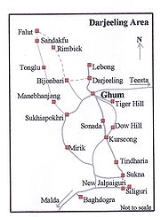
Ghum is the meeting point of several roads. The Hill Cart Road from Siliguri to Darjeeling runs through the town. It is 6 km from Darjeeling. It is 24 km from KurseongKurseong
Kurseong is a hill station situated in Darjeeling district of West Bengal, India.Located at an altitude of 1458 metres , Kurseong is just 30 km from Darjeeling...
via Sonada
Sonada
Sonada is a small town in the Darjeeling District of West Bengal, India. It is 17 km from Darjeeling town and 9 km from Kurseong. Mirik is 23 km away, Ghoom 5 km, Mangpu 8 km and Takdah 11 km. It lies on National Highway 55 connecting Darjeeling with Siliguri. Oaks Tea Estate, Mondakotee Tea...
. Kalimpong is about 45 km away via Lopchu. Another road leads to Mongpu and then on to the Kalimpong-Siliguri road. There is a road to Kurseong via Dow Hill. Sukhiapokhri
Sukhiapokhri
Sukhiapokhri is a small hilly locality in the Darjeeling district of West Bengal, India. Located almost on the India-Nepal border, it is 11 km from Ghum on the way to Mirik....
, almost on the India-Nepal border, is 11 km on the road to Mirik
Mirik
Mirik is a picturesque tourist spot nestled in the serene hills of Darjeeling district in West Bengal, India. The name Mirik comes from the Lepcha words Mir-Yok meaning "place burnt by fire"....
.
Construction of the Darjeeling Himalayan Railway started in 1879 and the railway track reached Ghum on 4 April 1881. Until 1878, the journey from Kolkata to Darjeeling took 5-6 days – using steam-engine-pulled trains, crossing the Ganges by steam ferry at Sahebganj, and then using bullock carts and palanquins. In 1878, Siliguri was put on the railway map of India, cutting down the journey to two days. In 2007, the train journey from Kolkata to New Jalpaiguri (a new railway station 6 km from Siliguri) takes about 10 hours. Thereafter it is 3-4 hours to Ghum or Darjeeling by road or 6-7 hours by the Darjeeling Himalayan Railway. Those who are not eager to travel all the way from New Jalpaiguri to Darjeeling by the slow train climbing up the hill can enjoy a ride on the tourist train from Darjeeling to Ghum and back.
After climbing from Siliguri to Ghum, the train starts descending about 182.9 m (1,000 ft) to Darjeeling, first crossing the graceful double loop at Batasia (meaning windy place).
Ghum is claimed by some tourist literature to be the highest railway station in the world. In this context, it may be noted that the Qingzang railway
Qingzang railway
The Qinghai–Xizang railway, Qingzang railway, or Qinghai–Tibet railway , is a high-elevation railway that connects Xining, Qinghai Province, to Lhasa, Tibet Autonomous Region, in People's Republic of China....
in China, connecting Xining
Xining
Xining is the capital of Qinghai province, People's Republic of China, and the largest city on the Tibetan Plateau. It has 2,208,708 inhabitants at the 2010 census whom 1,198,304 live in the built up area made of 4 urban districts.-History:...
, Qinghai Province
Qinghai
Qinghai ; Oirat Mongolian: ; ; Salar:) is a province of the People's Republic of China, named after Qinghai Lake...
, to Lhasa
Lhasa
Lhasa is the administrative capital of the Tibet Autonomous Region in the People's Republic of China and the second most populous city on the Tibetan Plateau, after Xining. At an altitude of , Lhasa is one of the highest cities in the world...
, Tibet Autonomous Region
Tibet Autonomous Region
The Tibet Autonomous Region , Tibet or Xizang for short, also called the Xizang Autonomous Region is a province-level autonomous region of the People's Republic of China , created in 1965....
, operates at heights of 4,000 metres to above 5,000 metres. The line was opened in 2006. In Switzerland
Rail transport in Switzerland
The railways of Switzerland include and narrow gauge .*Network size: 5,063 km*standard gauge: , of which is electrified.*narrow gauge: , of which is electrified...
, the Jungfraubahn
Jungfraubahn
The Jungfraubahn is an gauge rack railway electrified at 3-phase 1,125 volts 50 Hertz, which runs 9 kilometres from Kleine Scheidegg to the highest railway station in Europe at Jungfraujoch...
(JB) is an 1 m (3 ft 33⁄8 in) gauge rack railway
Rack railway
A rack-and-pinion railway is a railway with a toothed rack rail, usually between the running rails. The trains are fitted with one or more cog wheels or pinions that mesh with this rack rail...
which runs 9 kilometres from Kleine Scheidegg
Kleine Scheidegg
The Kleine Scheidegg is a high mountain pass below and between the Eiger and Lauberhorn peaks in the Bernese Oberland, Switzerland. It connects Grindelwald with Lauterbrunnen. The name means "minor watershed", even though it is actually higher than the neighbouring Grosse Scheidegg...
to the highest railway station in Europe
Europe
Europe is, by convention, one of the world's seven continents. Comprising the westernmost peninsula of Eurasia, Europe is generally 'divided' from Asia to its east by the watershed divides of the Ural and Caucasus Mountains, the Ural River, the Caspian and Black Seas, and the waterways connecting...
at Jungfraujoch
Jungfraujoch
The Jungfraujoch is a col or saddle between the Mönch and the Jungfrau in the Bernese Alps on the boundary between the cantons of Bern and Valais, inside the Jungfrau-Aletsch Protected Area....
(elevation 3471 m.)
War Memorial
Darjeeling hills has a high concentration of Indian Army servicemen and ex-servicemen. Since independence in 1947, seventy-six brave soldiers of the Darjeeling area have laid down their lives for their motherland. In 1976, Manish Gupta, then Deputy Commissioner of Darjeeling took the initiative to build a War Memorial and a committee was formed. In 1984, Batasia was selected as the site of the War Memorial. In 1991, Subhas Ghising, Chairman of Darjeeling Gorkha Autonomous Hill Council, agreed to finance the construction of the War Memorial.The War Memorial consists of a sanctified raised oval platform, 37’ x 24’ , with a 9 feet (2.7 m) high bronze statue and a 30 feet (9.1 m) high triangular granite cenotaph, on a 3 foot (0.9144 m) octagonal base, with the Roll of honour engraved on it. The bronze statue was sculptured by Gautam Pal of Krishnanagar.
Monasteries
Sampten Choling Gompa, is more popular as Ghum MonasteryGhoom Monastery
Ghum Monastery or Ghoom Monastery is the popular name of the Sampten Choling Monastery or Yiga Choeling Monastery located at Ghum at an elevation of 8,000 feet, 8 km from Darjeeling in the state of West Bengal, India....
. It is located below Hill Cart road and Ghum.railway station. It enshrines an image of the Maitreya Buddha. This monastery built in 1875 belongs to the Yellow sect of the Buddhists who worship a 15 feet (4.6 m) statue of the ‘Coming Buddha’.. There are three other gompas in Ghum - Yigachoeling, the Sakyachoeling, and the Phin.
Tiger Hill
Tiger HillTiger Hill, Darjeeling
Tiger Hill is the summit of Ghoom, the highest railway station on the Darjeeling Himalayan Railway – a UNESCO World Heritage Site. It is famous for spectacular sunrise view over the Himalayas...
is 5 km from Ghum and is located 1100 feet (335.3 m) higher than Ghum. On a clear day, the entire Darjeeling area offers a grand view of Kanchanjunga, the third highest peak in the world, but Tiger Hill additionally offers a view of top of Mount Everest
Mount Everest
Mount Everest is the world's highest mountain, with a peak at above sea level. It is located in the Mahalangur section of the Himalayas. The international boundary runs across the precise summit point...
, the
highest peak in the world. Thousands of tourists wake up early in the morning and rush to Tiger Hill for a glimpse of the famed sunrise. Many of them return without that view because Ghum and the surrounding areas are also an abode of the clouds, but few regret the experience whatever it is.
In the same region is Senchel water reservoir
Senchal Lake
Senchal lake, located 10 km to the south-east of Darjeeling, is the main reservoir of potable water for the town of Darjeeling, India. The lake is located at an altitude of 8,160 ft atop a hill. The hill also has a golf course and is one of the highest golf courses in the world. Senchal is a...
, at a height of 8163 feet (2,488.1 m), for the supply of water to Darjeeling town.