
Georgia State Route 57
Encyclopedia
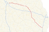
State Route 57 is a west–east state route located in the central part of the U.S. state
of Georgia
. The route travels from U.S. Route 80
/State Route 19 east of Macon
east, then southeast, to Interstate 95
north of Darien
.
and Wilkinson Counties
before arriving in Irwinton
. The route leaves Irwinton to the east, continuing to Wrightsville
. After a brief cosignage
with State Route 15 and State Route 78 in downtown Wrightsville, State Route 57 continues east. Just west of Swainsboro
, State Route 57 becomes cosigned with U.S. Route 80/State Route 26, and the three routes continue east into downtown Swainsboro. In downtown, State Route 57 departs U.S. Route 80/State Route 26 and becomes cosigned with U.S. Route 1
/State Route 4, and the three routes travel south. South of Swainsboro, State Route 57 departs and continues southeast. After intersecting Interstate 16
southeast of Stillmore
, the route continues southeast to the community of Cobbtown
, where the route becomes cosigned with State Route 23/State Route 121. The three routes travel south. South of Reidsville
, State Route 121 departs and State Routes 23 and 57 continue southeast into Glennville
, where the two routes become cosigned with State Route 144 shortly before entering downtown. In downtown, State Route 144 continues to the east, and State Routes 23 and 57 become cosigned with U.S. Route 25
/U.S. Route 301
, and all four routes travel southeast to Ludowici
. In Ludowici, State Route 57 departs the other three routes and continues southeast through the small community of Townsend
to its eastern terminus near Eulonia
at exit 58 on Interstate 95
, where State Route 99
also meets its northern terminus.
State Route 57 sees an Average Annual Daily Traffic of less than 5,000 vehicles for its length except around Macon, Reidsville, and other cities. The portion of State Route 57 east of the Wilkinson County line is part of the Fall Line Freeway
, an expressway
connecting Columbus
and Augusta
.
U.S. state
A U.S. state is any one of the 50 federated states of the United States of America that share sovereignty with the federal government. Because of this shared sovereignty, an American is a citizen both of the federal entity and of his or her state of domicile. Four states use the official title of...
of Georgia
Georgia (U.S. state)
Georgia is a state located in the southeastern United States. It was established in 1732, the last of the original Thirteen Colonies. The state is named after King George II of Great Britain. Georgia was the fourth state to ratify the United States Constitution, on January 2, 1788...
. The route travels from U.S. Route 80
U.S. Route 80
U.S. Route 80 is an east–west United States highway, much of which was once part of the early auto trail known as the Dixie Overland Highway. As the "0" in the route number indicates, it was originally a cross-country route, from the Atlantic to the Pacific...
/State Route 19 east of Macon
Macon, Georgia
Macon is a city located in central Georgia, US. Founded at the fall line of the Ocmulgee River, it is part of the Macon metropolitan area, and the county seat of Bibb County. A small portion of the city extends into Jones County. Macon is the biggest city in central Georgia...
east, then southeast, to Interstate 95
Interstate 95 in Georgia
Interstate 95, the main Interstate Highway on the east coast of the United States, serves the Atlantic coast of Georgia. It begins at the St. Marys River at the Florida state line north of Jacksonville and heads north past the border of South Carolina at the Savannah River...
north of Darien
Darien, Georgia
Darien is a city in McIntosh County, Georgia, United States. It lies on Georgia's coast at the mouth of the Altamaha River about 50 miles south of Savannah, and is part of the Brunswick, Georgia Metropolitan Statistical Area. The population of Darien was 1,719 at the 2000 census. The city is the...
.
Route description
From its western terminus at U.S. Route 80/State Route 19 east of Macon, State Route 57 travels east, through rural portions of TwiggsTwiggs County, Georgia
Twiggs County is a county located in the U.S. state of Georgia. It was created on December 14, 1809. As of 2000, the population was 10,590. The 2007 Census Estimate shows a population of 10,280...
and Wilkinson Counties
Wilkinson County, Georgia
Wilkinson County is a county located in the U.S. state of Georgia. It was created on May 11, 1803. As of 2000, the population was 10,220. The 2007 Census Estimate shows a population of 10,064...
before arriving in Irwinton
Irwinton, Georgia
Irwinton is a city in Wilkinson County, Georgia, United States. The population was 583 at the 2010 census. The city is the county seat of Wilkinson County.-Geography:Irwinton is located at ....
. The route leaves Irwinton to the east, continuing to Wrightsville
Wrightsville, Georgia
Wrightsville is a city in Johnson County, Georgia, United States. The population was 2,223 at the 2000 census. It was established February 23, 1886. It was named for James B. Wright, one of the members of the committee responsible for selecting the site for the town...
. After a brief cosignage
Concurrency (road)
A concurrency, overlap, or coincidence in a road network is an instance of one physical road bearing two or more different highway, motorway, or other route numbers...
with State Route 15 and State Route 78 in downtown Wrightsville, State Route 57 continues east. Just west of Swainsboro
Swainsboro, Georgia
Swainsboro is a city located in Emanuel County, Georgia. As of the 2000 census, the city had a total population of 6,943. The city is the county seat of Emanuel County.-Geography:...
, State Route 57 becomes cosigned with U.S. Route 80/State Route 26, and the three routes continue east into downtown Swainsboro. In downtown, State Route 57 departs U.S. Route 80/State Route 26 and becomes cosigned with U.S. Route 1
U.S. Route 1
U.S. Route 1 is a major north–south U.S. Highway that serves the East Coast of the United States. It runs 2,377 miles from Fort Kent, Maine at the Canadian border south to Key West, Florida. U.S. 1 generally parallels Interstate 95, though it is significantly farther west between...
/State Route 4, and the three routes travel south. South of Swainsboro, State Route 57 departs and continues southeast. After intersecting Interstate 16
Interstate 16
Interstate 16 , also known as Jim Gillis Historic Savannah Parkway or State Route 404 , is an intrastate Interstate Highway located entirely within the state of Georgia, United States...
southeast of Stillmore
Stillmore, Georgia
Stillmore is a town in Emanuel County, Georgia, United States. The population was 730 at the 2000 census.It is the home to David Emanuel Academy and the David Emanuel Academy Eagles who won the State GISA Basketball Championship in 2007.-Geography:...
, the route continues southeast to the community of Cobbtown
Cobbtown, Georgia
Cobbtown is a city in Tattnall County, Georgia, United States. The population was 311 at the 2000 census.-Geography:Cobbtown is located at ....
, where the route becomes cosigned with State Route 23/State Route 121. The three routes travel south. South of Reidsville
Reidsville, Georgia
Reidsville is a city in Tattnall County, Georgia, United States. The population was 2,235 at the 2000 census. The city is the county seat of Tattnall County...
, State Route 121 departs and State Routes 23 and 57 continue southeast into Glennville
Glennville, Georgia
Glennville is a city in Tattnall County, Georgia, United States. The population was 3,641 at the 2000 census.-Geography:Glennville is located at ....
, where the two routes become cosigned with State Route 144 shortly before entering downtown. In downtown, State Route 144 continues to the east, and State Routes 23 and 57 become cosigned with U.S. Route 25
U.S. Route 25
U.S. Route 25 is a north–south United States highway that runs for from Brunswick, Georgia to the Ohio state line in Covington, Kentucky.-Georgia:...
/U.S. Route 301
U.S. Route 301
U.S. Route 301 is a spur of U.S. Route 1 running through the South Atlantic States. It currently runs 1,099 miles from Glasgow, Delaware at U.S. Route 40 to Sarasota, Florida. It passes through the states of Delaware, Maryland, Virginia, North Carolina, South Carolina, Georgia, and Florida...
, and all four routes travel southeast to Ludowici
Ludowici, Georgia
Ludowici is a city in Long County, Georgia, United States. The population was 1,440 at the 2000 census. The city is the county seat of Long County...
. In Ludowici, State Route 57 departs the other three routes and continues southeast through the small community of Townsend
Townsend, Georgia
Townsend is an unincorporated community in McIntosh County, Georgia, United States. It lies along State Route 57 northwest of the city of Darien, the county seat of McIntosh County. Its elevation is 20 feet . Although it is unincorporated, it has a post office, with the ZIP code of 31331....
to its eastern terminus near Eulonia
Eulonia, Georgia
Eulonia is an unincorporated community in McIntosh County in the U.S. state of Georgia. It is part of the 'Brunswick, Georgia Metropolitan Statistical Area'. It is situated between Savannah and Brunswick just off Interstate 95.-Culture:...
at exit 58 on Interstate 95
Interstate 95 in Georgia
Interstate 95, the main Interstate Highway on the east coast of the United States, serves the Atlantic coast of Georgia. It begins at the St. Marys River at the Florida state line north of Jacksonville and heads north past the border of South Carolina at the Savannah River...
, where State Route 99
Georgia State Route 99
State Route 99 is a state highway located in southeast Georgia in Glynn County and McIntosh County. It roughly follows an old Indian trading trail....
also meets its northern terminus.
State Route 57 sees an Average Annual Daily Traffic of less than 5,000 vehicles for its length except around Macon, Reidsville, and other cities. The portion of State Route 57 east of the Wilkinson County line is part of the Fall Line Freeway
Fall Line Freeway
The Fall Line Freeway is a highway currently being constructed that will run the width of the state of Georgia from Columbus to Augusta, passing through several cities including Macon and Milledgeville. It will be designated State Route 540 upon completion, and it will be a four-lane divided...
, an expressway
Limited-access road
A limited-access road known by various terms worldwide, including limited-access highway, dual-carriageway and expressway, is a highway or arterial road for high-speed traffic which has many or most characteristics of a controlled-access highway , including limited or no access to adjacent...
connecting Columbus
Columbus, Georgia
Columbus is a city in and the county seat of Muscogee County, Georgia, United States, with which it is consolidated. As of the 2010 census, the city had a population of 189,885. It is the principal city of the Columbus, Georgia metropolitan area, which, in 2009, had an estimated population of 292,795...
and Augusta
Augusta, Georgia
Augusta is a consolidated city in the U.S. state of Georgia, located along the Savannah River. As of the 2010 census, the Augusta–Richmond County population was 195,844 not counting the unconsolidated cities of Hephzibah and Blythe.Augusta is the principal city of the Augusta-Richmond County...
.