
Georgetown, Colorado
Encyclopedia
The historic town of Georgetown is a Territorial Charter Municipality that is the county seat
of Clear Creek County
, Colorado
, United States
. The former silver
mining
camp along Clear Creek
in the Front Range
of the Rocky Mountains
was established in 1859 during the Pike's Peak Gold Rush. The federally designated Georgetown-Silver Plume National Historic District comprises Georgetown, the neighboring Town of Silver Plume
, and the Georgetown Loop Historic Mining & Railroad Park between the two towns. The town population was 1,088 at the U.S. Census 2000. The Georgetown Post Office
has the ZIP Code
80444.
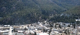
The town sits at an elevation of 8530 feet (2600 m), nestled in the mountains near the upper end of the valley of Clear Creek
in the mountains west of Denver
along Interstate 70. Although a small town today, the town was a historic center of the mining
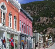
industry in Colorado during the late 19th century, earning the nickname the "Silver Queen of Colorado". It has evolved into a lively historical summer tourist center today with many preserved structures from the heyday of the Colorado Silver Boom
. The town stretches roughly north-south along Clear Creek, hemmed in by the mountains, with the historic downtown located at the southern (upper) end and modern development located at the northern (lower) end of town.
 The town was founded in 1859 during the Pike's Peak Gold Rush by George and David Griffith, two prospectors from Kentucky
. It was named "Georgetown" in honor of the older of the two brothers. Although founded during the gold rush, the town grew rapidly following the discovery of silver
on September 14, 1864 by James Huff at a site approximately 8 miles (12.9 km) up the canyon in the Argentine Pass
area. In the following years, thousands of mines were dug in the mountains surrounding the town and the town quickly grew into a center for prospectors and mine workers in the surrounding mountains. Located in the valley floor, the town itself was not a mining camp but a center of commerce and entertainment for miners in the surrounding mountains.
 Georgetown was incorporated on 1868-01-10, and a few months later it wrested the county seat
from nearby Idaho Springs
, which is a much larger community today. The historic courthouse dates from this year. Georgetown is the only Colorado municipality
that still operates under a charter
from the Territory of Colorado. The building of the narrow gauge Colorado Central Railroad
up the canyon from Golden
in the 1870s further increased the central position of the town. Although most of the railroad was later removed, a portion remained between the town and Silver Plume
and is operated today as a tourist railroad called the Georgetown Loop
. The town experienced its greatest growth and prosperity during the Colorado silver boom
of the 1880s when it rivaled Leadville
to the west as the mining capital of Colorado. At one time, before the collapse of the silver boom in 1893, the town population exceeded 10,000 and a movement arose briefly among local citizens to move the state capital there from Denver.
Following the collapse of the Silver Boom, the town population dwindled. In the 1950s the town began to experience a small renaissance as an après-ski
watering hole for the thousands of skiers
who passed through the town on their way down from the mountains at the ski areas near Loveland Pass
and Guanella Pass
. Small craft shops began to set up businesses in the once decrepit 19th century storefronts. By the late 1960s, the establishment of a museum in one of the historic hotels had made the town a popular summer tourist destination where visitors could relive the experience of walking among structures from the mining boom.
The historic downtown was used as the location for the filming of a scene from the 1978 movie Every Which Way But Loose starring Clint Eastwood
. The scene features the climactic showdown between Philo Beddoe (Eastwood's character) and the Black Widows motorcycle gang. The town was also used in the 1998 film Phantoms (film)
which included the historic Hotel de Paris, as well as the colonial-style post office.
The made-for-TV movie The Christmas Gift, starring John Denver
, was also filmed in Georgetown in 1986. The film is about a widower and his daughter who go to Georgetown for vacation and business and find the true meaning of Christmas.
According to the United States Census Bureau
, the town has a total area of 1 square miles (2.6 km²), of which, 0.9 square miles (2.3 km²) of it is land and 0.1 square mile (0.258998811 km²) of it (7.77%) is water.
of 2000, there were 1,088 people, 503 households, and 278 families residing in the town. The population density
was 1,146.2 people per square mile (442.2/km²). There were 670 housing units at an average density of 705.8 per square mile (272.3/km²). The racial makeup of the town was 95.96% White, 0.18% African American, 0.74% Native American, 0.28% Asian, 0.18% Pacific Islander, 1.10% from other races
, and 1.56% from two or more races. Hispanic or Latino of any race were 4.41% of the population.
There were 503 households out of which 24.1% had children under the age of 18 living with them, 44.1% were married couples
living together, 8.3% had a female householder with no husband present, and 44.7% were non-families. 34.6% of all households were made up of individuals and 5.2% had someone living alone who was 65 years of age or older. The average household size was 2.08 and the average family size was 2.67.
In the town the population was spread out with 19.0% under the age of 18, 7.9% from 18 to 24, 33.9% from 25 to 44, 31.0% from 45 to 64, and 8.2% who were 65 years of age or older. The median age was 39 years. For every 100 females there were 109.2 males. For every 100 females age 18 and over, there were 112.3 males.
The median income for a household in the town was $42,969, and the median income for a family was $53,333. Males had a median income of $35,952 versus $28,068 for females. The per capita income
for the town was $25,180. About 3.4% of families and 6.2% of the population were below the poverty line, including 7.1% of those under age 18 and 7.0% of those age 65 or over.
County seat
A county seat is an administrative center, or seat of government, for a county or civil parish. The term is primarily used in the United States....
of Clear Creek County
Clear Creek County, Colorado
Clear Creek County is one of the 64 counties of the state of Colorado of the United States. The county population was 9,322 at U.S. Census 2000. The county seat is Georgetown...
, Colorado
Colorado
Colorado is a U.S. state that encompasses much of the Rocky Mountains as well as the northeastern portion of the Colorado Plateau and the western edge of the Great Plains...
, United States
United States
The United States of America is a federal constitutional republic comprising fifty states and a federal district...
. The former silver
Silver
Silver is a metallic chemical element with the chemical symbol Ag and atomic number 47. A soft, white, lustrous transition metal, it has the highest electrical conductivity of any element and the highest thermal conductivity of any metal...
mining
Mining
Mining is the extraction of valuable minerals or other geological materials from the earth, from an ore body, vein or seam. The term also includes the removal of soil. Materials recovered by mining include base metals, precious metals, iron, uranium, coal, diamonds, limestone, oil shale, rock...
camp along Clear Creek
Clear Creek (Colorado)
Clear Creek is a tributary of the South Platte River, approximately long, in north central Colorado in the United States. The creek flows through Clear Creek Canyon in the Rocky Mountains directly west of Denver, descending through a long gorge to emerge on the Colorado Eastern Plains where it...
in the Front Range
Front Range
The Front Range is a mountain range of the Southern Rocky Mountains of North America located in the north-central portion of the U.S. State of Colorado and southeastern portion of the U.S. State of Wyoming. It is the first mountain range encountered moving west along the 40th parallel north across...
of the Rocky Mountains
Rocky Mountains
The Rocky Mountains are a major mountain range in western North America. The Rocky Mountains stretch more than from the northernmost part of British Columbia, in western Canada, to New Mexico, in the southwestern United States...
was established in 1859 during the Pike's Peak Gold Rush. The federally designated Georgetown-Silver Plume National Historic District comprises Georgetown, the neighboring Town of Silver Plume
Silver Plume, Colorado
The historic Town of Silver Plume is a Statutory Town located in Clear Creek County, Colorado, United States. Silver Plume is a former silver mining camp along Clear Creek in the Front Range of the Rocky Mountains...
, and the Georgetown Loop Historic Mining & Railroad Park between the two towns. The town population was 1,088 at the U.S. Census 2000. The Georgetown Post Office
United States Postal Service
The United States Postal Service is an independent agency of the United States government responsible for providing postal service in the United States...
has the ZIP Code
ZIP Code
ZIP codes are a system of postal codes used by the United States Postal Service since 1963. The term ZIP, an acronym for Zone Improvement Plan, is properly written in capital letters and was chosen to suggest that the mail travels more efficiently, and therefore more quickly, when senders use the...
80444.
The town sits at an elevation of 8530 feet (2600 m), nestled in the mountains near the upper end of the valley of Clear Creek
Clear Creek (Colorado)
Clear Creek is a tributary of the South Platte River, approximately long, in north central Colorado in the United States. The creek flows through Clear Creek Canyon in the Rocky Mountains directly west of Denver, descending through a long gorge to emerge on the Colorado Eastern Plains where it...
in the mountains west of Denver
Denver, Colorado
The City and County of Denver is the capital and the most populous city of the U.S. state of Colorado. Denver is a consolidated city-county, located in the South Platte River Valley on the western edge of the High Plains just east of the Front Range of the Rocky Mountains...
along Interstate 70. Although a small town today, the town was a historic center of the mining
Mining
Mining is the extraction of valuable minerals or other geological materials from the earth, from an ore body, vein or seam. The term also includes the removal of soil. Materials recovered by mining include base metals, precious metals, iron, uranium, coal, diamonds, limestone, oil shale, rock...
industry in Colorado during the late 19th century, earning the nickname the "Silver Queen of Colorado". It has evolved into a lively historical summer tourist center today with many preserved structures from the heyday of the Colorado Silver Boom
Colorado Silver Boom
The Colorado Silver Boom was a dramatic expansionist period of silver mining activity in the U.S. state of Colorado in the late 19th century. The boom started in 1879 with the discovery of silver at Leadville...
. The town stretches roughly north-south along Clear Creek, hemmed in by the mountains, with the historic downtown located at the southern (upper) end and modern development located at the northern (lower) end of town.
History
Kentucky
The Commonwealth of Kentucky is a state located in the East Central United States of America. As classified by the United States Census Bureau, Kentucky is a Southern state, more specifically in the East South Central region. Kentucky is one of four U.S. states constituted as a commonwealth...
. It was named "Georgetown" in honor of the older of the two brothers. Although founded during the gold rush, the town grew rapidly following the discovery of silver
Silver
Silver is a metallic chemical element with the chemical symbol Ag and atomic number 47. A soft, white, lustrous transition metal, it has the highest electrical conductivity of any element and the highest thermal conductivity of any metal...
on September 14, 1864 by James Huff at a site approximately 8 miles (12.9 km) up the canyon in the Argentine Pass
Argentine Pass
Argentine Pass, elevation , is a high mountain pass that crosses the Continental Divide in the Front Range of the Rocky Mountains of central Colorado in the United States....
area. In the following years, thousands of mines were dug in the mountains surrounding the town and the town quickly grew into a center for prospectors and mine workers in the surrounding mountains. Located in the valley floor, the town itself was not a mining camp but a center of commerce and entertainment for miners in the surrounding mountains.
County seat
A county seat is an administrative center, or seat of government, for a county or civil parish. The term is primarily used in the United States....
from nearby Idaho Springs
Idaho Springs, Colorado
The City of Idaho Springs is a municipality in the U.S. state of Colorado that is the most populous settlement in Clear Creek County, Colorado. Idaho Springs is located in Clear Creek Canyon, in the mountains upstream from Golden, some thirty miles west of Denver...
, which is a much larger community today. The historic courthouse dates from this year. Georgetown is the only Colorado municipality
Colorado municipalities
The U.S. state of Colorado currently has 271 active incorporated municipalities, including 196 towns, 73 cities, and two consolidated city and county governments.-Municipal government:...
that still operates under a charter
Charter
A charter is the grant of authority or rights, stating that the granter formally recognizes the prerogative of the recipient to exercise the rights specified...
from the Territory of Colorado. The building of the narrow gauge Colorado Central Railroad
Colorado Central Railroad
The Colorado Central Railroad was a U.S. railroad company that operated in Colorado and southeastern Wyoming in the late 19th century. Originally founded in the Colorado Territory in the wake of the Colorado Gold Rush to ship gold from the mountains, it eventually expanded from its initial...
up the canyon from Golden
Golden, Colorado
The City of Golden is a home rule municipality that is the county seat of Jefferson County, Colorado, United States. Golden lies along Clear Creek at the edge of the foothills of the Front Range of the Rocky Mountains. Founded during the Pike's Peak Gold Rush on 16 June 1859, the mining camp was...
in the 1870s further increased the central position of the town. Although most of the railroad was later removed, a portion remained between the town and Silver Plume
Silver Plume, Colorado
The historic Town of Silver Plume is a Statutory Town located in Clear Creek County, Colorado, United States. Silver Plume is a former silver mining camp along Clear Creek in the Front Range of the Rocky Mountains...
and is operated today as a tourist railroad called the Georgetown Loop
Georgetown Loop
The Georgetown Loop Railroad is a narrow gauge heritage railroad located in the Rocky Mountains in Clear Creek County, Colorado, in the United States....
. The town experienced its greatest growth and prosperity during the Colorado silver boom
Colorado Silver Boom
The Colorado Silver Boom was a dramatic expansionist period of silver mining activity in the U.S. state of Colorado in the late 19th century. The boom started in 1879 with the discovery of silver at Leadville...
of the 1880s when it rivaled Leadville
Leadville, Colorado
Leadville is a Statutory City that is the county seat of, and the only municipality in, Lake County, Colorado, United States. Situated at an elevation of , Leadville is the highest incorporated city and the second highest incorporated municipality in the United States...
to the west as the mining capital of Colorado. At one time, before the collapse of the silver boom in 1893, the town population exceeded 10,000 and a movement arose briefly among local citizens to move the state capital there from Denver.
Following the collapse of the Silver Boom, the town population dwindled. In the 1950s the town began to experience a small renaissance as an après-ski
Après-ski
Après-ski refers to going out, having drinks, dancing, and generally socializing after skiing. It is popular in the Alps, where skiers often stop at bars on their last run of the day while still wearing all their ski gear. The concept is similar to the nineteenth hole in golf. This can also...
watering hole for the thousands of skiers
Skiing
Skiing is a recreational activity using skis as equipment for traveling over snow. Skis are used in conjunction with boots that connect to the ski with use of a binding....
who passed through the town on their way down from the mountains at the ski areas near Loveland Pass
Loveland Pass
Loveland Pass, elevation 11,990 ft. above sea level, is a high mountain pass in the Rocky Mountains of north-central Colorado, U.S.A.....
and Guanella Pass
Guanella Pass
Guanella Pass is a high mountain pass in the Rocky Mountains of central Colorado, US.The pass is located in southwestern Clear Creek County, in the Front Range west of Denver and south of Georgetown....
. Small craft shops began to set up businesses in the once decrepit 19th century storefronts. By the late 1960s, the establishment of a museum in one of the historic hotels had made the town a popular summer tourist destination where visitors could relive the experience of walking among structures from the mining boom.
The historic downtown was used as the location for the filming of a scene from the 1978 movie Every Which Way But Loose starring Clint Eastwood
Clint Eastwood
Clinton "Clint" Eastwood, Jr. is an American film actor, director, producer, composer and politician. Eastwood first came to prominence as a supporting cast member in the TV series Rawhide...
. The scene features the climactic showdown between Philo Beddoe (Eastwood's character) and the Black Widows motorcycle gang. The town was also used in the 1998 film Phantoms (film)
Phantoms (film)
Phantoms is a 1998 American horror film adapted from the 1983 novel Phantoms by Dean Koontz. Joe Chappelle directed the film, and Koontz wrote the screenplay. The film takes place in the peaceful town of Snowfield, Colorado, where something evil has wiped out the community...
which included the historic Hotel de Paris, as well as the colonial-style post office.
The made-for-TV movie The Christmas Gift, starring John Denver
John Denver
Henry John Deutschendorf, Jr. , known professionally as John Denver, was an American singer/songwriter, activist, and humanitarian. After growing up in numerous locations with his military family, Denver began his music career in folk music groups in the late 1960s. His greatest commercial success...
, was also filmed in Georgetown in 1986. The film is about a widower and his daughter who go to Georgetown for vacation and business and find the true meaning of Christmas.
Geography
Georgetown is located at 39°42′45"N 105°41′45"W (39.712381, -105.695845).According to the United States Census Bureau
United States Census Bureau
The United States Census Bureau is the government agency that is responsible for the United States Census. It also gathers other national demographic and economic data...
, the town has a total area of 1 square miles (2.6 km²), of which, 0.9 square miles (2.3 km²) of it is land and 0.1 square mile (0.258998811 km²) of it (7.77%) is water.
Demographics
As of the censusCensus
A census is the procedure of systematically acquiring and recording information about the members of a given population. It is a regularly occurring and official count of a particular population. The term is used mostly in connection with national population and housing censuses; other common...
of 2000, there were 1,088 people, 503 households, and 278 families residing in the town. The population density
Population density
Population density is a measurement of population per unit area or unit volume. It is frequently applied to living organisms, and particularly to humans...
was 1,146.2 people per square mile (442.2/km²). There were 670 housing units at an average density of 705.8 per square mile (272.3/km²). The racial makeup of the town was 95.96% White, 0.18% African American, 0.74% Native American, 0.28% Asian, 0.18% Pacific Islander, 1.10% from other races
Race (United States Census)
Race and ethnicity in the United States Census, as defined by the Federal Office of Management and Budget and the United States Census Bureau, are self-identification data items in which residents choose the race or races with which they most closely identify, and indicate whether or not they are...
, and 1.56% from two or more races. Hispanic or Latino of any race were 4.41% of the population.
There were 503 households out of which 24.1% had children under the age of 18 living with them, 44.1% were married couples
Marriage
Marriage is a social union or legal contract between people that creates kinship. It is an institution in which interpersonal relationships, usually intimate and sexual, are acknowledged in a variety of ways, depending on the culture or subculture in which it is found...
living together, 8.3% had a female householder with no husband present, and 44.7% were non-families. 34.6% of all households were made up of individuals and 5.2% had someone living alone who was 65 years of age or older. The average household size was 2.08 and the average family size was 2.67.
In the town the population was spread out with 19.0% under the age of 18, 7.9% from 18 to 24, 33.9% from 25 to 44, 31.0% from 45 to 64, and 8.2% who were 65 years of age or older. The median age was 39 years. For every 100 females there were 109.2 males. For every 100 females age 18 and over, there were 112.3 males.
The median income for a household in the town was $42,969, and the median income for a family was $53,333. Males had a median income of $35,952 versus $28,068 for females. The per capita income
Per capita income
Per capita income or income per person is a measure of mean income within an economic aggregate, such as a country or city. It is calculated by taking a measure of all sources of income in the aggregate and dividing it by the total population...
for the town was $25,180. About 3.4% of families and 6.2% of the population were below the poverty line, including 7.1% of those under age 18 and 7.0% of those age 65 or over.
See also
- State of Colorado
- Colorado cities and towns
- Colorado municipalitiesColorado municipalitiesThe U.S. state of Colorado currently has 271 active incorporated municipalities, including 196 towns, 73 cities, and two consolidated city and county governments.-Municipal government:...
- Colorado municipalities
- Colorado countiesColorado countiesThe U.S state of Colorado is divided into 64 counties. Counties are important units of government in Colorado since the state has no secondary civil subdivisions, such as townships...
- Clear Creek County, ColoradoClear Creek County, ColoradoClear Creek County is one of the 64 counties of the state of Colorado of the United States. The county population was 9,322 at U.S. Census 2000. The county seat is Georgetown...
- Clear Creek County, Colorado
- Colorado geography
- Clear Creek (Colorado)Clear Creek (Colorado)Clear Creek is a tributary of the South Platte River, approximately long, in north central Colorado in the United States. The creek flows through Clear Creek Canyon in the Rocky Mountains directly west of Denver, descending through a long gorge to emerge on the Colorado Eastern Plains where it...
- Clear Creek (Colorado)
- Colorado history
- Territory of Colorado
- Colorado Silver BoomColorado Silver BoomThe Colorado Silver Boom was a dramatic expansionist period of silver mining activity in the U.S. state of Colorado in the late 19th century. The boom started in 1879 with the discovery of silver at Leadville...
- Georgetown-Silver Plume National Historic District
- Colorado metropolitan areasColorado metropolitan areasThe metropolitan areas of the State of Colorado include the urban statistical areas defined by the United States Office of Management and Budget and regions of urban population defined by other organizations.-Census statistical areas:...
- Boulder Metropolitan Statistical Area
- Denver-Aurora-Boulder Combined Statistical AreaDenver-Aurora-Boulder Combined Statistical Areathumb|300px|Map of the 12-county Denver-Aurora-Boulder Combined Statistical AreaThe Denver-Aurora-Boulder, CO Combined Statistical Area is a United States Census Bureau defined Combined Statistical Area located in the Denver region of the state of Colorado...
- North Central Colorado Urban AreaNorth Central Colorado Urban Areathumb|240px|An enlargeable map of the 13-county North Central Colorado Urban AreaThe North Central Colorado Urban Area comprises the four contiguous metropolitan statistical areas in the north central region of the State of Colorado: the Denver-Aurora Metropolitan Statistical Area, the Boulder...
- Front Range Urban CorridorFront Range Urban CorridorThe Front Range Urban Corridor is an oblong region of urban population located along the eastern face of the Southern Rocky Mountains in the U.S. states of Colorado and Wyoming. The corridor derives its name from the Front Range, the mountain range that defines the west central boundary of the...
- Colorado cities and towns
- United States Forest ServiceUnited States Forest ServiceThe United States Forest Service is an agency of the United States Department of Agriculture that administers the nation's 155 national forests and 20 national grasslands, which encompass...
- Arapaho National ForestArapaho National ForestArapaho National Forest is a National Forest located in north-central Colorado, United States. The facility is managed jointly with the Roosevelt National Forest and the Pawnee National Grassland from the United States Forest Service office in Fort Collins, Colorado...
- Arapaho National Forest
Local publication
- Historic Georgetown: Centennial Gazette 1868–1968