
Geography of Liechtenstein
Encyclopedia
Liechtenstein
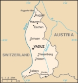
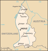
The Principality of Liechtenstein is a doubly landlocked alpine country in Central Europe, bordered by Switzerland to the west and south and by Austria to the east. Its area is just over , and it has an estimated population of 35,000. Its capital is Vaduz. The biggest town is Schaan...
encompasses most of the right (eastern) half of the Rhine Valley
Rhine Valley
The Rhine Valley is a glacial alpine valley, formed by the Alpine Rhine , i.e. the section of the Rhine River between the confluence of the Anterior Rhine and Posterior Rhine at Reichenau and its mouth at Lake Constance....
, wedged between Austria
Austria
Austria , officially the Republic of Austria , is a landlocked country of roughly 8.4 million people in Central Europe. It is bordered by the Czech Republic and Germany to the north, Slovakia and Hungary to the east, Slovenia and Italy to the south, and Switzerland and Liechtenstein to the...
and Switzerland
Switzerland
Switzerland name of one of the Swiss cantons. ; ; ; or ), in its full name the Swiss Confederation , is a federal republic consisting of 26 cantons, with Bern as the seat of the federal authorities. The country is situated in Western Europe,Or Central Europe depending on the definition....
.
Along with Uzbekistan
Uzbekistan
Uzbekistan , officially the Republic of Uzbekistan is a doubly landlocked country in Central Asia and one of the six independent Turkic states. It shares borders with Kazakhstan to the west and to the north, Kyrgyzstan and Tajikistan to the east, and Afghanistan and Turkmenistan to the south....
, Liechtenstein is one of only two doubly landlocked countries in the world; great variety of microclimate
Microclimate
A microclimate is a local atmospheric zone where the climate differs from the surrounding area. The term may refer to areas as small as a few square feet or as large as many square miles...
s based on elevation
Data from the CIA Factbook:
- Geographic coordinates:
47°10′N 9°32′E
- AreaAreaArea is a quantity that expresses the extent of a two-dimensional surface or shape in the plane. Area can be understood as the amount of material with a given thickness that would be necessary to fashion a model of the shape, or the amount of paint necessary to cover the surface with a single coat...
: 160 km²1 E8 m²To help compare different orders of magnitude and geographical regions, listed below are areas between 100 km2 and 1000 km2. See also areas of other orders of magnitude.* Areas less than 100 km2* 100 km2 is equal to:** 1 E+8 m²...
(land, 0 km² water) - Land boundaries: total: 76 km1 E4 mTo help compare different orders of magnitude this page lists lengths between 10 and 100 kilometres . The myriametre is a deprecated unit name; the prefix myria- is obsolete, not included among the prefixes when the International System of Units was introduced in 1960.Distances shorter than 10...
; border countries: Austria 35 km, Switzerland 41 km - Coastline: 0 km (landlocked)
- Maritime claims: none (landlocked)
- ClimateClimateClimate encompasses the statistics of temperature, humidity, atmospheric pressure, wind, rainfall, atmospheric particle count and other meteorological elemental measurements in a given region over long periods...
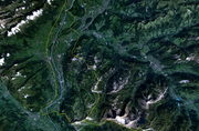
: continental; cold, cloudy winters with frequent snow or rain; cool to moderately warm, cloudy, humid summers, great variety of microclimates based on elevation - TerrainTerrainTerrain, or land relief, is the vertical and horizontal dimension of land surface. When relief is described underwater, the term bathymetry is used...
: mostly mountainous (Alps) with Rhine Valley in western third - Natural resourcesNatural ResourcesNatural Resources is a soul album released by Motown girl group Martha Reeves and the Vandellas in 1970 on the Gordy label. The album is significant for the Vietnam War ballad "I Should Be Proud" and the slow jam, "Love Guess Who"...
: hydroelectric potential, arable land - Lake: The only lake in Liechtenstein is the Gampriner SeeleGampriner SeeleGampriner Seele is the only lake in Liechtenstein. It was created by a flood of the Rhine River with enormous erosion in 1927. The lake lies on 435 metres above Sea Level in the village of Bendern–Gamprin....
. - Land use: arable land: 24%, permanent crops: 0%, permanent pastures: 16%, forests and woodland: 35%, other: 25% (1993 est.)
- Natural hazards: Death by mountain, e.g. avalanches,.
- Environment - international agreements:
- party to:
Air Pollution
Convention on Long-Range Transboundary Air Pollution
The Convention on Long-Range Transboundary Air Pollution, often abbreviated as Air Pollution or CLRTAP, is intended to protect the human environment against air pollution and to gradually reduce and prevent air pollution, including long-range transboundary air pollution.-Overview:The convention...
,
Air Pollution-Nitrogen Oxides
Nitrogen Oxide Protocol
Protocol to the 1979 Convention on Long-Range Transboundary Air Pollution Concerning the Control of Emissions of Nitrogen Oxides or Their Transboundary Fluxes, opened for signature on 31 October 1988 and entered into force on 14 February 1991, was to provide for the control or reduction of nitrogen...
,
Air Pollution-Sulphur 85, Air Pollution-Sulphur 94
Sulphur Emissions Reduction Protocol
The Protocol to the 1979 Convention on Long-Range Transboundary Air Pollution on the Reduction of Sulphur Emissions or Their Transboundary Fluxes by at Least 30% is an agreement to provide for a 30% reduction in sulphur emissions or transboundary fluxes by 1993....
,
Air Pollution-Volatile Organic Compounds
Volatile Organic Compounds Protocol
The Protocol to the 1979 Convention on Long-Range Transboundary Air Pollution Concerning the Control of Emissions of Volatile Organic Compounds or Their Transboundary Fluxes is an agreement to provide for the control and reduction of emissions of volatile organic compounds in order to reduce their...
,
Biodiversity
Convention on Biological Diversity
The Convention on Biological Diversity , known informally as the Biodiversity Convention, is an international legally binding treaty...
,
Climate Change
United Nations Framework Convention on Climate Change
The United Nations Framework Convention on Climate Change is an international environmental treaty produced at the United Nations Conference on Environment and Development , informally known as the Earth Summit, held in Rio de Janeiro from June 3 to 14, 1992...
,
Desertification
United Nations Convention to Combat Desertification
The United Nations Convention to Combat Desertification in Those Countries Experiencing Serious Drought and/or Desertification, Particularly in Africa is a Convention to combat desertification and mitigate the effects of drought through national action programs that incorporate long-term strategies...
,
Endangered Species,
Hazardous Wastes
Basel Convention
The Basel Convention on the Control of Transboundary Movements of Hazardous Wastes and Their Disposal, usually known simply as the Basel Convention, is an international treaty that was designed to reduce the movements of hazardous waste between nations, and specifically to prevent transfer of...
,
Ozone Layer Protection,
Wetlands,
-
- signed, but not ratified:
Air Pollution-Persistent Organic Pollutants,
Climate Change-Kyoto Protocol
Kyoto Protocol
The Kyoto Protocol is a protocol to the United Nations Framework Convention on Climate Change , aimed at fighting global warming...
,
Law of the Sea
United Nations Convention on the Law of the Sea
The United Nations Convention on the Law of the Sea , also called the Law of the Sea Convention or the Law of the Sea treaty, is the international agreement that resulted from the third United Nations Conference on the Law of the Sea , which took place from 1973 through 1982...
- Extreme points:
- North - River Rhine 47°16′15"N 9°31′51"E
- South - summit of MazorakopfMazorakopfMazorakopf or Falknishorn is a mountain on the border between Switzerland and Liechtenstein. It is the southernmost point of the principality of Liechtenstein....
/Falknishorn (2452 m) 47°2′55"N 9°33′26"E - East - border post 28, above Nenzinger Himmel 47°2′55"N 9°33′26"E
- West - River Rhine 47°3′46"N 9°28′18"E
- highest - Vorder Grauspitz (2599 m) 47°3′10"N 9°34′54"E
- lowest - Bangserfeld (429 m) 47°15′57"N 9°32′14"E