
Geography of Kuwait
Encyclopedia

Kuwait
The State of Kuwait is a sovereign Arab state situated in the north-east of the Arabian Peninsula in Western Asia. It is bordered by Saudi Arabia to the south at Khafji, and Iraq to the north at Basra. It lies on the north-western shore of the Persian Gulf. The name Kuwait is derived from the...
is situated in Southwest Asia
Southwest Asia
Western Asia, West Asia, Southwest Asia or Southwestern Asia are terms that describe the westernmost portion of Asia. The terms are partly coterminous with the Middle East, which describes a geographical position in relation to Western Europe rather than its location within Asia...
, bordering the Persian Gulf
Persian Gulf
The Persian Gulf, in Southwest Asia, is an extension of the Indian Ocean located between Iran and the Arabian Peninsula.The Persian Gulf was the focus of the 1980–1988 Iran-Iraq War, in which each side attacked the other's oil tankers...
, between Iraq
Iraq
Iraq ; officially the Republic of Iraq is a country in Western Asia spanning most of the northwestern end of the Zagros mountain range, the eastern part of the Syrian Desert and the northern part of the Arabian Desert....
and Saudi Arabia
Saudi Arabia
The Kingdom of Saudi Arabia , commonly known in British English as Saudi Arabia and in Arabic as as-Sa‘ūdiyyah , is the largest state in Western Asia by land area, constituting the bulk of the Arabian Peninsula, and the second-largest in the Arab World...
. Once a small Persian Gulf sheikhdom known locally as a center for pearl diving and boat construction, Kuwait came to international prominence in the post-World War II
World War II
World War II, or the Second World War , was a global conflict lasting from 1939 to 1945, involving most of the world's nations—including all of the great powers—eventually forming two opposing military alliances: the Allies and the Axis...
era largely because of its enormous oil
Petroleum
Petroleum or crude oil is a naturally occurring, flammable liquid consisting of a complex mixture of hydrocarbons of various molecular weights and other liquid organic compounds, that are found in geologic formations beneath the Earth's surface. Petroleum is recovered mostly through oil drilling...
revenues. Yet its history as an autonomous political entity is much older, dating back to the eighteenth century. At that time, the town of Kuwait was settled by migrants from central Arabia who arrived at what was then a lightly populated fishing village under the suzerainty of the Bani Khalid
Bani Khalid
.'Bani Khalid'. is an Arab tribal confederation of eastern and central Arabia. The tribe dominated the eastern region of modern-day Saudi Arabia from 1670 to 1793, and again under the auspices of the Ottoman Empire for a brief period in the early 19th century...
tribe of Arabia. Members of one family, the Al Sabah, have ruled Kuwait from that time.
Since 2007 Kuwait has been ruled by Shaykh sabah al Ahmad al Jabir Al Sabah and his designated successor, Shaykh Nawaf al Ahmaid al Jabir Al Sabah, the prime minister and crown prince
Crown Prince
A crown prince or crown princess is the heir or heiress apparent to the throne in a royal or imperial monarchy. The wife of a crown prince is also titled crown princess....
. In the postwar period, these men have supported, with some ambivalence, the strengthening of popular participation in decision making as provided for in the constitution.
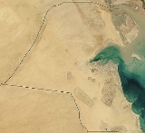
Kuwait is located at the far northwestern corner of the Persian Gulf. It is a small state of 17,820 square kilometers, a little smaller than the state of New Jersey. At its most distant points, it is about 200 kilometers north to south and 170 kilometers east to west.
Geographic coordinates:
- 29°30′N 47°30′E
Boundaries
Shaped roughly like a triangle, Kuwait borders the Persian GulfPersian Gulf
The Persian Gulf, in Southwest Asia, is an extension of the Indian Ocean located between Iran and the Arabian Peninsula.The Persian Gulf was the focus of the 1980–1988 Iran-Iraq War, in which each side attacked the other's oil tankers...
to the east, with 195 kilometers of coast. Kuwait includes within its territory nine Persian Gulf
Persian Gulf
The Persian Gulf, in Southwest Asia, is an extension of the Indian Ocean located between Iran and the Arabian Peninsula.The Persian Gulf was the focus of the 1980–1988 Iran-Iraq War, in which each side attacked the other's oil tankers...
islands, two of which, Bubiyan (the largest) and Warbah
Warbah Island
Warbah Island is an island belonging to Kuwait, located in the Persian Gulf, near the mouth of the Euphrates River. It is located roughly east of the Kuwaiti mainland, north of Bubiyan Island and south of the Iraqi mainland. It is roughly long and wide with a total area of...
, are largely uninhabited but strategically important. The island of Faylakah, at the mouth of Kuwait Bay, is also largely uninhabited as people did not return to their homes after the Iraqi invasion. It is believed to be the outermost point of the ancient civilization of Dilmun
Dilmun
Dilmun or Telmun is a land mentioned by Mesopotamian civilizations as a trade partner, a source of the metal copper, and an entrepôt of the Mesopotamia-to-Indus Valley Civilization trade route...
, which was centered in what is present-day Bahrain. Faylakah is the site of an ancient Greek temple built by the forces of Alexander the Great. Kuwait's most prominent geographic feature is Kuwait Bay, which indents the shoreline for about forty kilometers, providing natural protection for the port of Kuwait and accounting for nearly onehalf the state's shoreline.
To the south and west, Kuwait shares a long border of 250 kilometers with Saudi Arabia. The boundary between Kuwait and Saudi Arabia was set by the Treaty of Al Uqayr in 1922, which also established the Kuwait-Saudi Arabia neutral zone of 5,700 square kilometers. In 1966 Kuwait and Saudi Arabia agreed to divide the Neutral Zone; the partitioning agreement making each country responsible for administration in its portion was signed in December 1969. The resources in the area, since known as the Divided Zone, are not affected by the agreement, and the oil from onshore and offshore fields continues to be shared equally between the two countries.
The third side of the triangle is the 240 kilometers of historically contested border to the north and west that Kuwait shares with Iraq. Although the Iraqi government, which had first asserted a claim to rule Kuwait in 1938, recognized the borders with Kuwait in 1963 (based on agreements made earlier in the century), it continued to press Kuwait for control over Bubiyan and Warbah islands through the 1960s and 1970s. In August 1990, Iraq invaded Kuwait and, shortly thereafter, formally incorporated the entire country into Iraq. Under United Nations
United Nations
The United Nations is an international organization whose stated aims are facilitating cooperation in international law, international security, economic development, social progress, human rights, and achievement of world peace...
(UN) Security Council Resolution 687, after the restoration of Kuwaiti sovereignty in 1991, a UN commission undertook formal demarcation of the borders on the basis of those agreed to in 1963. The boundary was demarcated in 1992, but Iraq refuses to accept the commission's findings.
Recent events from 2008 to the present day have seen the positive advancement of maritime border relations with Iraq with the development of the Khawr Abd Allah (KAA) Protocols. The non-legally binding KAA Protocols were developed and mediated between the heads of the Kuwaiti and Iraqi navies by Major David Hammond Royal Marines, the British naval lawyer and legal advisor to Combined Task Force 158
Combined Task Force 158
Combined Task Force Iraqi Maritime or CTF IM is an international naval task group, established as a result of Operation Iraqi Freedom. It consists of naval assets from the United States Navy and Coast Guard, the Royal Australian Navy and the Royal Navy, working alongside elements of the Iraqi...
. This included the production of the KAA Interoperability Admiralty Chart by Major Hammond and which was subsequently distributed to both countries, having been produced by the United Kingdom Hydrographic Office. On November 11, 2008, the KAA Protocols were historically signed at Kuwait Naval Base having been verbally agreed onboard HMS Chatham (F87)
HMS Chatham (F87)
HMS Chatham was a Batch 3 Type 22 frigate of the British Royal Navy. She has the rare honour of a motto in English; Up and at 'em, being the rallying cry of the Medway town football and rugby teams. The motto has subsequently been translated back into Latin as Surge et vince...
on 8 May 2008. The signing meeting saw the first formal meeting of the heads of respective navies since before the 1991 Gulf War
Gulf War
The Persian Gulf War , commonly referred to as simply the Gulf War, was a war waged by a U.N.-authorized coalition force from 34 nations led by the United States, against Iraq in response to Iraq's invasion and annexation of Kuwait.The war is also known under other names, such as the First Gulf...
. Subsequently, the success of the non-legally binding protocols was reported to the US Congress on January 9, 2009 in the Measuring Stability and Security in Iraq Report.
Climate
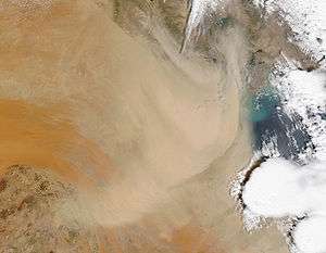
The summers are relentlessly long, punctuated mainly by dramatic dust storms in June and July when northwesterly winds cover the cities in sand. In late summer, which is more humid, there are occasional sharp, brief thunderstorms. By November, all of the hot weather is over, and colder winter weather sets in, dropping temperatures to as low as 0 °C (32 °F) at night; daytime temperature is in the 15–20 °C (59–68 °F) range. Frost occurs when the temperatures are at least below 5 °C (41 °F); rain is more common and falls mostly in the winter and spring. Kuwait's Winter is colder compared to all the other Persian Gulf countries like Bahrain, Qatar or UAE. Kuwait experiences colder weather because is in a northern position, and because of cold winds from upper Iraq and Iran.
and this and that he :)
Area boundaries
Area:- Total: 17,820 km²
- Land: 17,820 km²
- Water: 0 km²
Area—comparative:
- Slightly smaller than New JerseyNew JerseyNew Jersey is a state in the Northeastern and Middle Atlantic regions of the United States. , its population was 8,791,894. It is bordered on the north and east by the state of New York, on the southeast and south by the Atlantic Ocean, on the west by Pennsylvania and on the southwest by Delaware...
Land boundaries:
- Total: 462 km
- Border countries: IraqIraqIraq ; officially the Republic of Iraq is a country in Western Asia spanning most of the northwestern end of the Zagros mountain range, the eastern part of the Syrian Desert and the northern part of the Arabian Desert....
240 km, Saudi ArabiaSaudi ArabiaThe Kingdom of Saudi Arabia , commonly known in British English as Saudi Arabia and in Arabic as as-Sa‘ūdiyyah , is the largest state in Western Asia by land area, constituting the bulk of the Arabian Peninsula, and the second-largest in the Arab World...
222 km
Coastline:
- 499 km
Maritime claims:
- Territorial sea: 12 nmi (22.2 km; 13.8 mi)
Elevation extremes:
- Lowest point: Persian GulfPersian GulfThe Persian Gulf, in Southwest Asia, is an extension of the Indian Ocean located between Iran and the Arabian Peninsula.The Persian Gulf was the focus of the 1980–1988 Iran-Iraq War, in which each side attacked the other's oil tankers...
0 m - Highest point: unnamed location 306 m
Resources and land use
Natural resources:- PetroleumPetroleumPetroleum or crude oil is a naturally occurring, flammable liquid consisting of a complex mixture of hydrocarbons of various molecular weights and other liquid organic compounds, that are found in geologic formations beneath the Earth's surface. Petroleum is recovered mostly through oil drilling...
, fishFishFish are a paraphyletic group of organisms that consist of all gill-bearing aquatic vertebrate animals that lack limbs with digits. Included in this definition are the living hagfish, lampreys, and cartilaginous and bony fish, as well as various extinct related groups...
, shrimpShrimpShrimp are swimming, decapod crustaceans classified in the infraorder Caridea, found widely around the world in both fresh and salt water. Adult shrimp are filter feeding benthic animals living close to the bottom. They can live in schools and can swim rapidly backwards. Shrimp are an important...
, natural gasNatural gasNatural gas is a naturally occurring gas mixture consisting primarily of methane, typically with 0–20% higher hydrocarbons . It is found associated with other hydrocarbon fuel, in coal beds, as methane clathrates, and is an important fuel source and a major feedstock for fertilizers.Most natural...
Land use:
- Arable land: 0.84%
- Permanent crops: 0.17%
- Other: 98.99% (2005 est.)
Irrigated land:
- 130 km² (2003 est.)
Environmental concerns
Natural hazards:- Sudden cloudbursts are common from October to April; they bring heavy rain which can damage roads and houses; sandstorms and dust storms occur throughout the year, but are most common between March and August
Environment—current issues:
- Limited natural fresh water resources; some of world's largest and most sophisticated desalination facilities provide much of the water; air and water pollution; desertification
Environment—international agreements:
- Party to: Climate ChangeUnited Nations Framework Convention on Climate ChangeThe United Nations Framework Convention on Climate Change is an international environmental treaty produced at the United Nations Conference on Environment and Development , informally known as the Earth Summit, held in Rio de Janeiro from June 3 to 14, 1992...
, DesertificationDesertificationDesertification is the degradation of land in drylands. Caused by a variety of factors, such as climate change and human activities, desertification is one of the most significant global environmental problems.-Definitions:...
, Environmental Modification, Hazardous Wastes, Law of the SeaLaw of the seaLaw of the sea may refer to:* United Nations Convention on the Law of the Sea* Admiralty law* The Custom of the Sea...
, Marine Dumping, Nuclear Test Ban, Ozone Layer Protection - Signed, but not ratified: BiodiversityBiodiversityBiodiversity is the degree of variation of life forms within a given ecosystem, biome, or an entire planet. Biodiversity is a measure of the health of ecosystems. Biodiversity is in part a function of climate. In terrestrial habitats, tropical regions are typically rich whereas polar regions...
, Endangered SpeciesEndangered speciesAn endangered species is a population of organisms which is at risk of becoming extinct because it is either few in numbers, or threatened by changing environmental or predation parameters...
, Marine Dumping
Geography—note:
- Strategic location at head of Persian GulfPersian GulfThe Persian Gulf, in Southwest Asia, is an extension of the Indian Ocean located between Iran and the Arabian Peninsula.The Persian Gulf was the focus of the 1980–1988 Iran-Iraq War, in which each side attacked the other's oil tankers...