

Geography of Houston
Encyclopedia
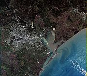
Houston is located in the gulf coastal plains biome
Biome
Biomes are climatically and geographically defined as similar climatic conditions on the Earth, such as communities of plants, animals, and soil organisms, and are often referred to as ecosystems. Some parts of the earth have more or less the same kind of abiotic and biotic factors spread over a...
, and its vegetation is classified as temperate grassland. Much of the city was built on marsh
Marsh
In geography, a marsh, or morass, is a type of wetland that is subject to frequent or continuous flood. Typically the water is shallow and features grasses, rushes, reeds, typhas, sedges, other herbaceous plants, and moss....
es, swamp
Swamp
A swamp is a wetland with some flooding of large areas of land by shallow bodies of water. A swamp generally has a large number of hammocks, or dry-land protrusions, covered by aquatic vegetation, or vegetation that tolerates periodical inundation. The two main types of swamp are "true" or swamp...
, or prairie
Prairie
Prairies are considered part of the temperate grasslands, savannas, and shrublands biome by ecologists, based on similar temperate climates, moderate rainfall, and grasses, herbs, and shrubs, rather than trees, as the dominant vegetation type...
—all of which can still be seen in surrounding areas.
Much of Houston is very flat, making flooding a recurring problem for its residents. The city stands about 50 feet above sea level—the highest area within city limits being 90 feet. However, coastal subsidence has caused the elevation to drop 10 feet or more in certain areas. The subsidence was caused by extensive use of ground water and the extraction of oil and natural gas. The city turned to ground-level water sources such as Lake Houston
Lake Houston
Lake Houston is a reservoir on the west fork of the San Jacinto River, 15 miles northeast of downtown Houston, Texas, USA. The reservoir is the secondary municipal water supply for the city of Houston after Lake Livingston....
which was created in 1953 and Lake Conroe
Lake Conroe
Lake Conroe is a 21,000 acre lake in Montgomery County, Texas, United States. Even though it is named Lake Conroe, only a small portion of the lake is in Conroe, Texas. Most of the lake is in Montgomery, Texas and Willis, Texas. The lake lies on the West Fork of the San Jacinto River just west of...
of which Houston owns two-thirds interest.
Houston has four major bayou
Bayou
A bayou is an American term for a body of water typically found in flat, low-lying areas, and can refer either to an extremely slow-moving stream or river , or to a marshy lake or wetland. The name "bayou" can also refer to creeks that see level changes due to tides and hold brackish water which...
s passing through the city: Buffalo Bayou
Buffalo Bayou
Buffalo Bayou is a main waterway flowing through Houston, in Harris County, Texas, USA. It begins in Katy, Fort Bend County, Texas and flows approximately east to the Houston Ship Channel and then into Galveston Bay and the Gulf of Mexico...
, which runs into downtown and the Houston Ship Channel
Houston Ship Channel
The Houston Ship Channel, located in Houston, Texas, is part of the Port of Houston—one of the United States's busiest seaports. The channel is the conduit for ocean-going vessels between the Houston-area shipyards and the Gulf of Mexico.-Overview:...
; and three of its tributaries: Brays Bayou, which runs along the Texas Medical Center
Texas Medical Center
The Texas Medical Center is the largest medical center in the world with one of the highest densities of clinical facilities for patient care, basic science, and translational research...
; White Oak Bayou, which runs through the Heights and near the northwest area; and Sims Bayou, which runs through the south of Houston and downtown Houston. The ship channel goes past Galveston
Galveston, Texas
Galveston is a coastal city located on Galveston Island in the U.S. state of Texas. , the city had a total population of 47,743 within an area of...
and into the Gulf of Mexico
Gulf of Mexico
The Gulf of Mexico is a partially landlocked ocean basin largely surrounded by the North American continent and the island of Cuba. It is bounded on the northeast, north and northwest by the Gulf Coast of the United States, on the southwest and south by Mexico, and on the southeast by Cuba. In...
.
Geology
Underpinning Houston's land surface are unconsolidated clayClay
Clay is a general term including many combinations of one or more clay minerals with traces of metal oxides and organic matter. Geologic clay deposits are mostly composed of phyllosilicate minerals containing variable amounts of water trapped in the mineral structure.- Formation :Clay minerals...
s, clay shale
Shale
Shale is a fine-grained, clastic sedimentary rock composed of mud that is a mix of flakes of clay minerals and tiny fragments of other minerals, especially quartz and calcite. The ratio of clay to other minerals is variable. Shale is characterized by breaks along thin laminae or parallel layering...
s, and poorly-cemented sand
Sand
Sand is a naturally occurring granular material composed of finely divided rock and mineral particles.The composition of sand is highly variable, depending on the local rock sources and conditions, but the most common constituent of sand in inland continental settings and non-tropical coastal...
s up to several miles deep. The region's geology
Geology
Geology is the science comprising the study of solid Earth, the rocks of which it is composed, and the processes by which it evolves. Geology gives insight into the history of the Earth, as it provides the primary evidence for plate tectonics, the evolutionary history of life, and past climates...
developed from stream deposits from the erosion of the Rocky Mountains
Rocky Mountains
The Rocky Mountains are a major mountain range in western North America. The Rocky Mountains stretch more than from the northernmost part of British Columbia, in western Canada, to New Mexico, in the southwestern United States...
. These sediment
Sediment
Sediment is naturally occurring material that is broken down by processes of weathering and erosion, and is subsequently transported by the action of fluids such as wind, water, or ice, and/or by the force of gravity acting on the particle itself....
s consist of a series of sands and clays deposited on decaying organic matter that, over time, transformed into oil and natural gas. Beneath these tiers is a water-deposited layer of halite
Halite
Halite , commonly known as rock salt, is the mineral form of sodium chloride . Halite forms isometric crystals. The mineral is typically colorless or white, but may also be light blue, dark blue, purple, pink, red, orange, yellow or gray depending on the amount and type of impurities...
, a rock salt. The porous layers were compressed over time and forced upward. As it pushed upward, the salt dragged surrounding sediments into dome shapes, often trapping oil and gas that seeped from the surrounding porous sands. This thick rich soil also provides a good environment for rice farming in suburban outskirts that the city continues to grow into near Katy
Katy, Texas
Katy is a city located in Harris, Fort Bend and Waller Counties in the U.S. state of Texas, within the Houston–Sugar Land–Baytown metropolitan area...
. Evidence of past rice
Rice
Rice is the seed of the monocot plants Oryza sativa or Oryza glaberrima . As a cereal grain, it is the most important staple food for a large part of the world's human population, especially in East Asia, Southeast Asia, South Asia, the Middle East, and the West Indies...
farming is even still evident in developed areas as there is an abundance of rich dark loamy top soil.
The Houston region is generally earthquake
Earthquake
An earthquake is the result of a sudden release of energy in the Earth's crust that creates seismic waves. The seismicity, seismism or seismic activity of an area refers to the frequency, type and size of earthquakes experienced over a period of time...
-free. While the city of Houston contains 86 mapped and historically active surface faults
Geologic fault
In geology, a fault is a planar fracture or discontinuity in a volume of rock, across which there has been significant displacement along the fractures as a result of earth movement. Large faults within the Earth's crust result from the action of tectonic forces...
with an aggregate length of 149 miles (240 km), the clay below the surface precludes the buildup of friction that produces ground shaking in earthquakes. These faults generally move at a smooth rate in what is termed "fault creep."
Cityscape


John Kirby Allen
John Kirby Allen was born in Canasareaugh, near Syracuse in the U.S. state of New York. He, along with his older brother, Augustus Chapman Allen, founded Houston, Texas in 1836. John Kirby Allen was never married...
and Augustus Chapman Allen
Augustus Chapman Allen
Augustus Chapman Allen , along with his younger brother, John Kirby Allen, founded the City of Houston in the U.S. state of Texas. He was born on July 4, 1806, in Canasareaugh, New York, to Sarah and Roland Allen.- Early years :...
—divided it into political geographic districts called "wards." The ward designation is the progenitor of the current-day Houston City Council districts—there are nine in all.
Locations in Houston are generally classified as either being inside or outside Interstate 610
Interstate 610 (Texas)
Interstate 610 is a freeway that forms a forty-two-mile loop around the downtown sector of city of Houston, Texas. Interstate 610, colloquially known as "The Loop", "Loop 610", "The 610 Loop", or just "610", traditionally marks the border between the inner city of Houston and its surrounding areas...
, known as the "610 Loop" or simply "The Loop". Inside the loop generally encompasses the central business district, and has come to define an urban lifestyle and state of mind. The appellation “inner looper” carries with it the expectation of someone who appreciates cosmopolitan-style city life.
The outlying areas of Houston, the airports and the city's suburbs and enclaves are outside the Loop. Another ring road, Beltway 8
State Highway Beltway 8 (Texas)
Beltway 8 , the Sam Houston Parkway, along with the Sam Houston Tollway, is an beltway around the city of Houston, Texas, United States, lying entirely within Harris County. Beltway 8, a state highway, runs mostly along the frontage roads, only using the main lanes where they are free...
(also known simply as the "Beltway" or as the "Sam Houston Tollway"), encircles the city another 5 miles (8 km) farther out. Parts of Beltway 8 are toll roads, but for most of the route motorists can drive in the adjacent "feeder" or service roads at no charge. The third ring road, State Highway 99
State Highway 99 (Texas)
State Highway 99, also known as the Grand Parkway, is a Texas highway, which opened its first section in 1994. When State Highway 99 is complete, it will be the longest beltway in the world, and the third loop within the Houston–Sugar Land–Baytown metropolitan area, with Interstate 610 being...
(also known as the Grand Parkway), is under construction.
Houston, being the largest city in the United States without zoning laws, has grown in an unusual manner. Rather than a single "downtown
Downtown Houston
Downtown Houston is the largest business district of Houston, Texas, United States. Downtown Houston, the city's central business district, contains the headquarters of many prominent companies. There is an extensive network of pedestrian tunnels and skywalks connecting the buildings of the district...
" as the center of the city's employment, five additional business district
Central business district
A central business district is the commercial and often geographic heart of a city. In North America this part of a city is commonly referred to as "downtown" or "city center"...
s have grown throughout the inner-city—they are Uptown
Uptown Houston
The Uptown District of Houston is located 6.2 miles west of downtown and is centered along Post Oak Boulevard, Westheimer Road , and the Galleria...
, Texas Medical Center
Texas Medical Center
The Texas Medical Center is the largest medical center in the world with one of the highest densities of clinical facilities for patient care, basic science, and translational research...
, Greenway Plaza
Greenway Plaza
Greenway Plaza is a master-planned mixed-use development off U.S. Highway 59 in Houston, Texas, United States, five miles west of Downtown Houston and three miles east of Uptown Houston. Greenway Plaza is Houston's first totally planned business-commercial-residential complex developed by the...
, Westchase
Westchase, Houston, Texas
Westchase is a business management district, with some residential and retail elements, located in western Houston, Texas, United States. The district is bounded roughly by Westheimer Road on the north, Gessner Road on the east, Wilcrest Drive on the west, and the Westpark Tollway on the south...
, and Greenspoint
Greenspoint, Houston, Texas
The Greater Greenspoint District is an edge city in northern Harris County, Texas, United States. Portions of the district are in the City of Houston while portions are in unincorporated areas...
. If these business districts were combined, they would form the third-largest downtown in the United States. The city also has the third-largest skyline
Skyline
A skyline is the overall or partial view of a city's tall buildings and structures consisting of many skyscrapers in front of the sky in the background. It can also be described as the artificial horizon that a city's overall structure creates. Skylines serve as a kind of fingerprint of a city, as...
in the country (after New York City and Chicago), but because it is spread over a few miles, pictures of the city show—for the most part—the main downtown area.