
.gif)
State Highway Beltway 8 (Texas)
Encyclopedia
Houston, Texas
Houston is the fourth-largest city in the United States, and the largest city in the state of Texas. According to the 2010 U.S. Census, the city had a population of 2.1 million people within an area of . Houston is the seat of Harris County and the economic center of , which is the ...
, United States
United States
The United States of America is a federal constitutional republic comprising fifty states and a federal district...
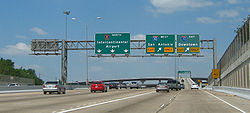
, lying entirely within Harris County. Beltway 8, a state highway
State highway
State highway, state road or state route can refer to one of three related concepts, two of them related to a state or provincial government in a country that is divided into states or provinces :#A...
, runs mostly along the frontage road
Frontage road
A frontage road is a non-limited access road running parallel to a higher-speed road, usually a freeway, and feeding it at appropriate points of access...
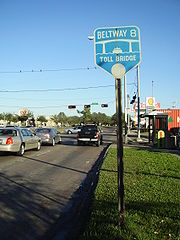
s, only using the main lanes where they are free (mostly on the north side of Houston). The main lanes elsewhere are the Sam Houston Tollway, a toll road
Toll road
A toll road is a privately or publicly built road for which a driver pays a toll for use. Structures for which tolls are charged include toll bridges and toll tunnels. Non-toll roads are financed using other sources of revenue, most typically fuel tax or general tax funds...
owned and operated by the Harris County Toll Road Authority
Harris County Toll Road Authority
The Harris County Toll Road Authority maintains and operates a toll road system in the Houston/Harris County area...
(HCTRA). East of Houston, the Tollway crosses the Houston Ship Channel
Houston Ship Channel
The Houston Ship Channel, located in Houston, Texas, is part of the Port of Houston—one of the United States's busiest seaports. The channel is the conduit for ocean-going vessels between the Houston-area shipyards and the Gulf of Mexico.-Overview:...
on the Sam Houston Ship Channel Bridge
Sam Houston Ship Channel Bridge
Sam Houston Tollway Ship Channel Bridge is a bridge in Harris County, Texas. It was acquired from the-then Texas Turnpike Authority on May 5, 1994 and is now a part of the Harris County Toll Road Authority system. The bridge opened to traffic in May 1982...
, a toll bridge
Toll bridge
A toll bridge is a bridge over which traffic may pass upon payment of a toll, or fee.- History :The practice of collecting tolls on bridges probably harks back to the days of ferry crossings where people paid a fee to be ferried across stretches of water. As boats became impractical to carry large...
; this forms a gap in Beltway 8 between Interstate Highway 10 (Baytown-East Freeway) and State Highway 225 (La Porte Freeway).
Beltway 8 is the intermediate beltway in the Houston area. The inner beltway - Interstate Highway 610 - lies completely within Houston (except for an approximate two mile (3 km) stretch that runs through the City of Bellaire
Bellaire, Texas
Bellaire is a city in southwest Harris County, Texas, United States, within the metropolitan area. As of the 2000 U.S. Census, the city population was 15,642 and is completely surrounded by the cities of Houston and West University Place....
), and the outer beltway - State Highway 99
State Highway 99 (Texas)
State Highway 99, also known as the Grand Parkway, is a Texas highway, which opened its first section in 1994. When State Highway 99 is complete, it will be the longest beltway in the world, and the third loop within the Houston–Sugar Land–Baytown metropolitan area, with Interstate 610 being...
(Grand Parkway) - is nowhere near complete.
Portions of the West Belt, as sections of the Beltway are called by their compass names, are in various stages of expansion due to high traffic volumes.
The Tollway's construction was piecemealed from the opening of the West Belt in the mid-1970s to the completion of the South Belt in the mid-1990s. The Jesse H. Jones Memorial Bridge
Sam Houston Ship Channel Bridge
Sam Houston Tollway Ship Channel Bridge is a bridge in Harris County, Texas. It was acquired from the-then Texas Turnpike Authority on May 5, 1994 and is now a part of the Harris County Toll Road Authority system. The bridge opened to traffic in May 1982...
, the Tollway's crossing of the Houston Ship Channel
Houston Ship Channel
The Houston Ship Channel, located in Houston, Texas, is part of the Port of Houston—one of the United States's busiest seaports. The channel is the conduit for ocean-going vessels between the Houston-area shipyards and the Gulf of Mexico.-Overview:...
, was constructed by the then-Texas Turnpike Authority (TTA) and was opened in 1982.
Like other toll roads in the Houston area
Greater Houston
Houston–Sugar Land–Baytown is a 10-county metropolitan area defined by the Office of Management and Budget. It is located along the Gulf Coast region in the U.S. state of Texas...
, the speed limit is 65 mi/h.
Despite recent speculation about the possibility of the Sam Houston Tollway being sold by HCTRA to a private firm, the Harris County Commissioners Court unanimously voted to keep the tollway in the hands of HCTRA.
As of September 3, 2007 the toll has increased by $0.25 system wide with some exceptions.
History
In 1989 the The BanglesThe Bangles
The Bangles are an American all-female band that originated in the early 1980s, scoring several hit singles during the decade.-Formation and early years :...
performed at the opening of the segment of Beltway 8 between Interstate 10
Interstate 10
Interstate 10 is the fourth-longest Interstate Highway in the United States, after I-90, I-80, and I-40. It is the southernmost east–west, coast-to-coast Interstate Highway, although I-4 and I-8 are further south. It stretches from the Pacific Ocean at State Route 1 in Santa Monica,...
(Katy Freeway) and U.S. Route 290. On Saturday July 7, 1990, a ceremony, called Road Party II, took place for the opening of the section of Beltway 8 between Interstate 45
Interstate 45
Interstate 45 is an intrastate Interstate Highway located entirely within the U.S. state of Texas. It connects the cities of Dallas and Houston, continuing southeast from Houston to Galveston over the Galveston Causeway to the Gulf of Mexico...
(the North Freeway) and Highway 290, the final segment. Organizers had planned for a crowd of 100,000. KLOL, a radio station, sponsored the event. Jerry Lightfoot & The Essential Band did the opening 80 minute set. The band Huey Lewis and the News
Huey Lewis and the News
Huey Lewis and the News is an American rock band based in San Francisco, California. They had a run of hit singles during the 1980s and early 1990s, eventually scoring a total of 19 top-ten singles across the Billboard Hot 100, Adult Contemporary and Mainstream Rock charts...
performed at the ceremony. The 290-45 segment opened on Sunday July 6, 1990. The project was on schedule and $133 million in 1990 U.S. dollars under budget.
On February 26, 2011, construction of the main lanes between U.S. Highway 59 (Eastex Freeway) and U.S. Highway 90 (Crosby Freeway) was completed, thus completing the entire Beltway system. This section was originally set to be completed between 2007 and 2009, but funding issues delayed its completion. The project cost $400 million and was completed ahead of schedule and under budget. The new 13 miles (20.9 km) section has three lanes in each direction, and an EZ Tag
EZ TAG
EZ TAG is an electronic toll collection system in Houston, Texas, United States that allows motorists to pay tolls without stopping at toll booths. Motorists with the Tags are allowed to use lanes reserved exclusively for them on all Harris County Toll Road Authority roads...
or TxTag
TxTAG
TxTag , operated by the Texas Department of Transportation , is one of three interoperable electronic toll collection systems in Texas.-Current system status:The TxTag brand name is used on the following highways:* Operated by TxDOT:...
will be required to access it. Almost 60 years had passed between the planning of Beltway 8 and the opening of the final section.
Enforcement
AMBER Alert
An AMBER Alert or a Child Abduction Emergency is a child abduction alert bulletin in several countries throughout the world, issued upon the suspected abduction of a child, since 1996...
. When a flagged vehicle is detected, it notifies the closest law enforcement officer to investigate. At this time, Precinct 5 Constables and Harris County Sheriff's Office
Harris County Sheriff's Office
The Harris County Sheriff's Office is a local law enforcement agency serving the over three million citizens of Harris County, Texas, United States. It is headquartered in the 1200 Jail in Downtown Houston.As of the 2000 U.S...
are being notified, but Houston Police Department
Houston Police Department
The Houston Police Department is the primary law enforcement agency serving the City of Houston, Texas, United States and some surrounding areas. Its headquarters are in 1200 Travis in Downtown Houston....
has shown interest and wishes to be included to be notified. The total number of cameras that are planned for the system is 35.
Free sections
The longest free section of main lanes is on the north side of Houston, stretching from Ella Boulevard east to Mesa Dr. This is maintained by the Texas Department of TransportationTexas Department of Transportation
The Texas Department of Transportation is a governmental agency in the U.S. state of Texas. Its stated mission is to "work cooperatively to provide safe, effective and efficient movement of people and goods" throughout the state...
east of roughly the Hardy Toll Road
Hardy Toll Road
The Hardy Toll Road runs from Interstate 610, near central Houston, to Interstate 45, north of Houston just below the Harris County line. The road generally parallels Interstate 45. The portion from I-610 to Crosstimbers Road is known as Spur 548, although this is unsigned.Construction on the...
interchange
Interchange (road)
In the field of road transport, an interchange is a road junction that typically uses grade separation, and one or more ramps, to permit traffic on at least one highway to pass through the junction without directly crossing any other traffic stream. It differs from a standard intersection, at which...
. It includes the interchanges with US 59, the Hardy Toll Road, and Interstate Highway 45 (North Freeway).
Three shorter free sections also exist:
- North of Wallisville Road to Jacinto Port Boulevard, including the Interstate Highway 10 (Baytown-East Freeway) interchange
- State Highway 3State Highway 3 (Texas)State Highway 3, or SH 3, is a state highway in the U.S. state of Texas that runs from Interstate 45 in Houston near William P. Hobby Airport to State Highway 146, northwest of Galveston...
(Galveston Road) to Beamer Road, including the Interstate Highway 45 (Gulf Freeway) interchange - West Airport Boulevard to Beechnut Street, including the U.S. Highway 59 (Southwest Freeway) interchange
These all exist in order to allow federal funding to have been used to build the freeway-to-freeway interchanges at the Baytown-East, Gulf and Southwest Freeways.
The frontage road
Frontage road
A frontage road is a non-limited access road running parallel to a higher-speed road, usually a freeway, and feeding it at appropriate points of access...
s are generally continuous, and allow for slower free travel along the tolled segments. Only one break exists in the frontage roads; there are also several locations where one must turn to stay on them:
- Jacinto Port Boulevard to State Highway 225 - the frontage roads do not cross the Houston Ship ChannelHouston Ship ChannelThe Houston Ship Channel, located in Houston, Texas, is part of the Port of Houston—one of the United States's busiest seaports. The channel is the conduit for ocean-going vessels between the Houston-area shipyards and the Gulf of Mexico.-Overview:...
(and thus that piece of Beltway 8 was removed in 1978) - Deerwood Drive to Boheme Drive - both directions are on the east side of the Tollway for the crossing of Buffalo BayouBuffalo BayouBuffalo Bayou is a main waterway flowing through Houston, in Harris County, Texas, USA. It begins in Katy, Fort Bend County, Texas and flows approximately east to the Houston Ship Channel and then into Galveston Bay and the Gulf of Mexico...
- West Little York Road to U.S. Highway 290 (Northwest Freeway) - both directions shift to the west side, intersecting US 290 at Senate Avenue, northwest of the Tollway
- At the Katy FreewayInterstate 10 in TexasInterstate 10 is the major east–west Interstate Highway in the Southern United States. In the U.S. state of Texas, it runs east from El Paso, near the border with New Mexico, through San Antonio and Houston to the border with Louisiana in Orange, Texas....
, some of the frontage road lanes bypass the intersection, allowing vehicles on the frontage road to travel through the interchange without stopping at traffic lights.
Lane configuration
The lane count is for mainlanes only, unless otherwise noted. Starting at U.S. Highway 290, and moving in a clockwise direction, mainlane counts are as follows:- 3 lanes each way between U.S. Highway 290 and State Highway 249 (work started in late 2006 to add a fourth lane in the clockwise direction)
- 4 lanes each way between Gessner Road and Interstate 45
- 3 lanes each way between Interstate 45 and J.F.K Boulevard
- 4 lanes each way between J.F.K Boulevard and U.S. Highway 59 (Eastex Freeway)
- 3 lanes each way between U.S. Highway 59 (Eastex Freeway) and Interstate 10 (East Freeway)
- 2 lanes each way between Interstate 10 (East Freeway) and State Highway 3 (Galveston Road)
- 3 lanes each way between State Highway 3 (Galveston Road) and Beamer Road
- 2 lanes each way between Beamer Road and U.S. Highway 59 (Southwest Freeway)
- 4 lanes each way between U.S. Highway 59 (Southwest Freeway) and U.S. Highway 290 (portions between Highway 59 and Westpark Tollway)
Exit list
Clockwise reads down and counterclockwise reads up.|-
|rowspan=72|Harris
Harris County, Texas
As of the 2010 Census, the population of the county was 4,092,459, White Americans made up 56.6% of Harris County's population; non-Hispanic whites represented 33.0% of the population. Black Americans made up 18.9% of the population. Native Americans made up 0.7% of Harris County's population...
|rowspan=5|Pasadena
Pasadena, Texas
Pasadena is a city in the U.S. state of Texas within the metropolitan area. It is the second-largest city in Harris County, 17th-largest in Texas, and 162nd largest in the United States. The area was founded in 1893 by John H. Burnett of Galveston....
|0.0
|
|
|-
|
|Red Bluff Road, Pasadena Boulevard
|
|-
|
|Spencer Highway, Vista Road, Pine Street
|
|-
|
|Fairmont Parkway, Vista Road
|
|-
|
|Genoa-Red Bluff Road, Preston Road, Crenshaw Road
|Clockwise exit is via the Fairmont Parkway exit
|-
|rowspan=11|Houston
|7.5
|
|
|-
|8.6
|
|
|-
|
|Sabo Road
|Clockwise exit and counterclockwise entrance
|-
|
|Beamer Road, Sabo Road, Hughes Road
|
|-
|
|Blackhawk Road
|Clockwise exit is via the Beamer Road exit
|-
|
|Pearland Parkway, Monroe Road
|Counterclockwise exit is via the SH 35 Hobby Airport exit
|-
|13.6
|
|
|-
|
|Mykawa Road
|Counterclockwise exit and clockwise entrance
|-
|
|South Wayside Drive
|
|-
|
|M.L. King Boulevard
|Clockwise exit and counterclockwise entrance
|-
|
|
|
|-
|
|
|
|
|-
|
|
|Kirby Drive
|Counterclockwise exit and clockwise entrance
|-
|
|
|
|
|-
|rowspan=4|Houston
|
|South Post Oak Road
|Counterclockwise exit is via the West Fuqua Street exit
|-
|
|West Fuqua Street
|
|-
|
|
|
|-
|
|Fondren Road
|Counterclockwise exit is via the US 90 Alt. exit
|-
|rowspan=2|Missouri City
Missouri City, Texas
Missouri City is a city located in the U.S. state of Texas within the metropolitan area. The city is mostly in Fort Bend County with a small portion within Harris County. As of the 2000 U.S...
|
|
|
|-
|
|South Gessner Road
|Counterclockwise exit is via West Airport Boulevard
|-
|rowspan=19|Houston
|
|West Airport Boulevard
|
|-
|
|West Bellfort Boulevard
|Clockwise exit and counterclockwise entrance
|-
|31.1
|
|
|-
|
|
|Counterclockwise exit only
|-
|32.2
|Bissonnet Street
|Counterclockwise CCW exit and clockwise entrance
|-
|
|Beechnut Street
|
|-
|
|Bellaire Boulevard, Westpark Drive
|
|-
|
|
|
|-
|36.3
|Westheimer Road
Westheimer Road
Westheimer Road is an arterial road in the western half of Houston, Texas, United States. It runs from Bagby Street west to the Westpark Tollway. Westheimer Road runs roughly parallel to and south of Buffalo Bayou throughout its course. The street was named after Michael Louis Westheimer, a...
(FM 1093), Richmond Avenue
|
|-
|
|Briar Forest Drive
|
|-
|
|Deerwood Drive
|Counterclockwise exit only
|-
|
|Boheme Drive
|Clockwise exit only
|-
|
|Memorial Drive
|Clockwise exit and counterclockwise entrance
|-
|39.6
|
|
|-
|
|Westview Drive
|Counterclockwise exit and clockwise entrance
|-
|
|Hammerly Boulevard, Kempwood Drive
|
|-
|
|Clay Road, Tanner Road, Kempwood Drive
|
|-
|
|West Little York Road
|Clockwise exit and counterclockwise entrance
|-
|46.0
|
|
|-
|
|
|West Road, Philippine Street
|
|-
|
|
|Fallbrook Drive, Windfern Road
|Counterclockwise exit is via the Gessner Road exit
|-
|
|
|Gessner Road, Fairbanks North Houston Road
|
|-
|
|52.3
|
|
|-
|
|
|Antoine Drive, Wirt Rd, Bammel North Houston Road
|Clockwise exit is via the SH 249 exit
|-
|
|
|Veterans Memorial Drive, T.C. Jester Boulevard
|No counterclockwise exit
|-
|rowspan=5|Houston
|
|
|
|-
|58.5
|
|
|-
|
|Greenspoint Drive, Imperial Valley Drive
|
|-
|
|Imperial Valley Drive
|Clockwise exit is via the Greenspoint Drive exit
|-
|
|
|
|-
|
|
|Aldine-Westfield Road
|No clockwise entrance
|-
|rowspan=3|Houston
|
|JFK Boulevard, Vickery Drive - Bush Intercontinental Airport
|
|-
|
|Lee Road, Vickery Drive
|
|-
|65.6
|
|
|-
|
|
|Mesa Drive
|
|-
|
|
|Wilson Road
|
|-
|
|
|John Ralston Road, Lockwood Road
|
|-
|
|
|West Lake Houston Parkway
West Lake Houston Parkway
The West Lake Houston Parkway serves as a major access road between the developing portion of Beltway 8 and the neighborhoods of Summerwood, Atascocita and Kingwood in the Greater Houston Area. The start of the road is just West of the Beltway in a developing neighborhood...
|
|-
|
|
|Winfield Road, North Lake Houston Parkway, CE King Parkway /
|
|-
|
|
|Garrett Road, Little York Road
|
|-
|
|
|, Tidwell Road
|
|-
|
|
|Wallisville Road
|
|-
|
|
|Woodforest Boulevard
|
|-
|
|
|Market Steet
|Counterclockwise exit and clockwise entrance
|-
|
|83.13
|
|
|-
|
|
|Jacinto Port Boulevard
|Clockwise exit and counterclockwise entrance