
Garkha
Encyclopedia
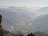
Garkha is the Himalayan fertile and lush green mountain country in front of Askot
region of Uttarakhand
state of India
in the Pithoragarh district
. This region tilted from South West to North East. Literally in Kumauni it means the herds of cows. Well linked with roads with Ogla
at its entry point. This place lies in the Kanalichhina
development block of Didihat
tehsil and sub division. This area is lies on the mountain on the northern slopes of western Himalayas.This place is full of Rhododendron
, Quercus, Myrica
and Pinus forests.In this place many villages lies between Dhanlek peak and Bagarihat and the plains of Titari on the left bank of river Kali on one at lower side. Once ruled by Rajbar
of Askot
and this place was long under the Gorkha
Kings of Nepal
. This area was the main area of commerce with river trade point at once flourshing trade city of Bagdihat, on the banks of river Kali.The main villages of the region are Ogla, Sighali, Sunakot, Digara, Udma, Barakot, Majhera, Agaon,Pantgaon,Naret, Ojhagaon,Bhulkhet, Bhagichaura-Town of Garkha(In Dangti Gram Sabha), Dangti, Dungara, Dokuna, Pasma, Bagadihat, Titari and Chausala.This region is scenically majestic with the view of Panchchuli
, Chhiplakot
and Annapurna
peaks of Himalaya.

Askot
Askot or Askote is a small Himalayan town in Pithoragarh district of Uttarakhand in India. It is the part of Kanalichhina development Block and Didihat Tehsil....
region of Uttarakhand
Uttarakhand
Uttarakhand , formerly Uttaranchal, is a state in the northern part of India. It is often referred to as the Land of Gods due to the many holy Hindu temples and cities found throughout the state, some of which are among Hinduism's most spiritual and auspicious places of pilgrimage and worship...
state of India
India
India , officially the Republic of India , is a country in South Asia. It is the seventh-largest country by geographical area, the second-most populous country with over 1.2 billion people, and the most populous democracy in the world...
in the Pithoragarh district
Pithoragarh District
Pithoragarh district is the easternmost Himalayan district in the state of Uttarakhand, India. It is naturally landscaped with high Himalayan mountains, snow capped peaks, passes, valleys, alpine meadows, forests, waterfalls, perennial rivers, glaciers and springs. The flora and fauna of this area...
. This region tilted from South West to North East. Literally in Kumauni it means the herds of cows. Well linked with roads with Ogla
Ogla
Ogla is a small scenic place in the Pithoragarh district of Uttarakhand state of India in the Didihat tehsil. It lies in the crossroads of Kailash Man sarover pilgrimage highway. It is a nice place for refreshment with local cuisine. Askot Musk Deer Sanctuary is situated near this place. Charama,...
at its entry point. This place lies in the Kanalichhina
Kanalichhina
Kanalichhina is the development block in Pithoragarh district of Uttarakhand state of India. The geographical latitude of this place is 29°40'33"N and the longitude is 80°16'20"E. Kanalichhina is so named after 'Chhin' in Kumauni means an open deep space between two hillocks characterized by...
development block of Didihat
Didihat
Didihat is a town and a nagar panchayat in Pithoragarh district in the state of Uttarakhand, India.-Etymology:Didihat is named after Kumauni language word 'Dand' means a small hillock.-Demographics:...
tehsil and sub division. This area is lies on the mountain on the northern slopes of western Himalayas.This place is full of Rhododendron
Rhododendron
Rhododendron is a genus of over 1 000 species of woody plants in the heath family, most with showy flowers...
, Quercus, Myrica
Myrica
Myrica is a genus of about 35–50 species of small trees and shrubs in the family Myricaceae, order Fagales. The genus has a wide distribution, including Africa, Asia, Europe, North America and South America, and missing only from Australasia...
and Pinus forests.In this place many villages lies between Dhanlek peak and Bagarihat and the plains of Titari on the left bank of river Kali on one at lower side. Once ruled by Rajbar
Rajbar
Rajbhar or Rajwar was the title of the erstwhile medieval Kings of Askot in Pithoragarh district of the Kumaon region of the Uttarakhand state of India.-Origin:...
of Askot
Askot
Askot or Askote is a small Himalayan town in Pithoragarh district of Uttarakhand in India. It is the part of Kanalichhina development Block and Didihat Tehsil....
and this place was long under the Gorkha
Gurkha
Gurkha are people from Nepal who take their name from the Gorkha District. Gurkhas are best known for their history in the Indian Army's Gorkha regiments, the British Army's Brigade of Gurkhas and the Nepalese Army. Gurkha units are closely associated with the kukri, a forward-curving Nepalese knife...
Kings of Nepal
Nepal
Nepal , officially the Federal Democratic Republic of Nepal, is a landlocked sovereign state located in South Asia. It is located in the Himalayas and bordered to the north by the People's Republic of China, and to the south, east, and west by the Republic of India...
. This area was the main area of commerce with river trade point at once flourshing trade city of Bagdihat, on the banks of river Kali.The main villages of the region are Ogla, Sighali, Sunakot, Digara, Udma, Barakot, Majhera, Agaon,Pantgaon,Naret, Ojhagaon,Bhulkhet, Bhagichaura-Town of Garkha(In Dangti Gram Sabha), Dangti, Dungara, Dokuna, Pasma, Bagadihat, Titari and Chausala.This region is scenically majestic with the view of Panchchuli
Panchchuli
The Panchchuli peaks are a group of five snow-capped Himalayan peaks lying at the end of the eastern Kumaon region, near Munsiyari, in Pithoragarh district, Uttarakhand state, India. The peaks have altitudes ranging from to . They form the watershed between the Gori and the Darmaganga valleys....
, Chhiplakot
Chhiplakot
Chhiplakot is the High Himalayan Mountain in the Pithoragarh district of Uttarakhand, India at an altitude of 3290 meters. Full of alpine flora and vegetation, Chhiplakot is famous for its lush green alpine meadow called Bugyal. The slopes provide a skii range, and a local cave plays host to a...
and Annapurna
Annapurna
Annapurna is a section of the Himalayas in north-central Nepal that includes Annapurna I, thirteen additional peaks over and 16 more over ....
peaks of Himalaya.