
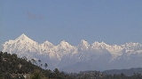
Panchchuli
Encyclopedia
The Panchchuli peaks are a group of five snow-capped Himalayan peaks lying at the end of the eastern Kumaon
region, near Munsiyari
, in Pithoragarh district
, Uttarakhand
state, India
. The peaks have altitudes ranging from 6334 metres (20,781 ft) to 6904 metres (22,651 ft). They form the watershed
between the Gori and the Darmaganga valleys. Panchchuli is also located on the Gori Ganga-Lassar Yankti divide. The group lies 138 km (86 mi) from Pithoragarh.
The five peaks on the Panchchuli massif
are numbered from northwest to southeast. The highest peak is Panchchuli II, which was first scaled by an Indo-Tibetan Border Police
expedition, led by Mahendra Singh, on 26 May, 1973. The group's name is derived the legendary Pandavas's "Five Chulis" (cooking hearths), where they cooked their last meal before proceeding toward their heavenly abode.
The coordinates of this peak are Latitude 30°13'12" Longitude 80° 25'12".
team, led by Mahendra Singh, on 26 May 1973. They climbed from the Balati plateau and via the southwest ridge to the summit. The coordinates of the peak are Latitude 30°12'51" Longitude 80°25'39".
expedition led by John Nankervis. The expedition members who summited were; John Nankervis (Wellington), Peter Cammell (Auckland), John Cocks (Dunedin), and Nick Shearer (Oamaru). Peter Platts (Christchurch) assisted the expedition as far as camp 2. The coordinates of this peak are Latitude 30°11'24" Longitude 80°27'00".
and Harish Kapadia
by the south ridge. The coordinates of this peak are Latitude 30°10'48" Longitude 80°28'12".
Kumaon Division
For Kumaoni/Kumauni People see Kumauni PeopleKumaon or Kumaun is one of the two regions and administrative divisions of Uttarakhand, a mountainous state of northern India, the other being Garhwal. It includes the districts of Almora, Bageshwar, Champawat, Nainital, Pithoragarh, and Udham Singh Nagar...
region, near Munsiyari
Munsiyari
Munsyari is the name of a town and a tehsil in the Pithoragarh District in the hill-state of Uttarakhand, India.It lies at the base of the great Himalayan mountain range, at an elevation of about , and is a starting point of various treks into the interior of the range.- Overview :Its name refers...
, in Pithoragarh district
Pithoragarh District
Pithoragarh district is the easternmost Himalayan district in the state of Uttarakhand, India. It is naturally landscaped with high Himalayan mountains, snow capped peaks, passes, valleys, alpine meadows, forests, waterfalls, perennial rivers, glaciers and springs. The flora and fauna of this area...
, Uttarakhand
Uttarakhand
Uttarakhand , formerly Uttaranchal, is a state in the northern part of India. It is often referred to as the Land of Gods due to the many holy Hindu temples and cities found throughout the state, some of which are among Hinduism's most spiritual and auspicious places of pilgrimage and worship...
state, India
India
India , officially the Republic of India , is a country in South Asia. It is the seventh-largest country by geographical area, the second-most populous country with over 1.2 billion people, and the most populous democracy in the world...
. The peaks have altitudes ranging from 6334 metres (20,781 ft) to 6904 metres (22,651 ft). They form the watershed
Water divide
A drainage divide, water divide, divide or watershed is the line separating neighbouring drainage basins...
between the Gori and the Darmaganga valleys. Panchchuli is also located on the Gori Ganga-Lassar Yankti divide. The group lies 138 km (86 mi) from Pithoragarh.
The five peaks on the Panchchuli massif
Massif
In geology, a massif is a section of a planet's crust that is demarcated by faults or flexures. In the movement of the crust, a massif tends to retain its internal structure while being displaced as a whole...
are numbered from northwest to southeast. The highest peak is Panchchuli II, which was first scaled by an Indo-Tibetan Border Police
Indo-Tibetan Border Police
The Indo-Tibetan Border Police is an Indian force conceived on October 24, 1962 for security along the India's border with the Tibet Autonomous Region of China, border covering 2115 kilometres...
expedition, led by Mahendra Singh, on 26 May, 1973. The group's name is derived the legendary Pandavas's "Five Chulis" (cooking hearths), where they cooked their last meal before proceeding toward their heavenly abode.
Five peaks of Panchchuli
Panchchuli-1 (6,355 m)
The first ascent of this peak was done by Indo-Tibet Border Police (ITBP) team in 1972, via Uttari Balati glacier, led by Hukam Singh.The coordinates of this peak are Latitude 30°13'12" Longitude 80° 25'12".
Panchchuli-2 (6,904 m)
This is the highest peak in the group. It was first climbed successfully by an Indo-Tibetan Border PoliceIndo-Tibetan Border Police
The Indo-Tibetan Border Police is an Indian force conceived on October 24, 1962 for security along the India's border with the Tibet Autonomous Region of China, border covering 2115 kilometres...
team, led by Mahendra Singh, on 26 May 1973. They climbed from the Balati plateau and via the southwest ridge to the summit. The coordinates of the peak are Latitude 30°12'51" Longitude 80°25'39".
Panchchuli-3 (6,312 m)
This peak is climbed successfully in 2001 through south eastern ridge. The coordinates of this peak are Latitude 30°12'00" Longitude 80°26'24".Panchchuli-4 (6,334 m)
The first ascent of this peak was made in 1995 by a New ZealandNew Zealand
New Zealand is an island country in the south-western Pacific Ocean comprising two main landmasses and numerous smaller islands. The country is situated some east of Australia across the Tasman Sea, and roughly south of the Pacific island nations of New Caledonia, Fiji, and Tonga...
expedition led by John Nankervis. The expedition members who summited were; John Nankervis (Wellington), Peter Cammell (Auckland), John Cocks (Dunedin), and Nick Shearer (Oamaru). Peter Platts (Christchurch) assisted the expedition as far as camp 2. The coordinates of this peak are Latitude 30°11'24" Longitude 80°27'00".
Panchchuli-5 (6,437 m)
The first ascent of this peak was made in 1992 by an Indo-British team jointly led by Chris BoningtonChris Bonington
Sir Christian John Storey Bonington, CVO, CBE, DL is a British mountaineer.His career has included nineteen expeditions to the Himalayas, including four to Mount Everest and the first ascent of the south face of Annapurna.-Early life and expeditions:Educated at University College School in...
and Harish Kapadia
Harish Kapadia
Harish Kapadia is a distinguished Himalayan Mountaineer from India. He has been awarded the Patron's Medal of the Royal Geographic Society, UK and the Life Time Achievement Award for Adventure by the President of India and the King Albert Mountain Award presented by The King Albert I Memorial...
by the south ridge. The coordinates of this peak are Latitude 30°10'48" Longitude 80°28'12".
Approaches to Panch-Chuli
- Eastern approach: via the Sona GlacierSona GlacierSona Glacier is the Himalayan glacier situated in the eastern part of Uttarakhand in the Pithoragarh district of India.Sona Glacier is located at the base of five peaks of Panchchuli in the Lassar Yankti - Darma valley.With Meola glacier it forms the famous Panchchuli glacier as mixed glacial system...
and Meola GlacierMeola GlacierMeola Glacier or Athasi-Balati Glacier is the Himalayan glacier situated in the eastern part of Uttarakhand in the Pithoragarh district of India. Meola Glacier is located at the base of the five peaks of Panchchuli in the Lassar Yankti valley....
. - Western approach: through the Uttari Balati Glacier via Balati Plateau.