
Grey Friar
Encyclopedia
Grey Friar is a fell
in the English Lake District
, it is one of the Coniston Fells
and is situated 13 kilometres west-south-west of Ambleside
. It reaches a height of 770 metres (2,526 feet) and stands to the north west of the other Coniston Fells, a little off the beaten track and tends to be the least visited of the group. It is quite a large fell and forms the eastern wall of the Duddon Valley
for several kilometres, in fact all drainage from Grey Friar goes to the Duddon Valley and not to Coniston Water
.
and runs south for around 10 miles before petering out at Broughton in Furness on the Duddon Estuary. Grey Friar is the only major fell in the group not to stand on this main axis, rising to the west of Great Carrs
across the depression of Fairfield.
Bounded to the north and west by the infant Duddon, Grey Friar has long rough slopes on this side with many small areas of crag. The southern perimeter is formed by Seathwaite Tarn
and its attendant streams. The tarn
was originally a much smaller waterbody, but was raised early in the 20th century to provide drinking water for the Barrow in Furness area. The dam is almost 400 yards long and is concrete cored with slate buttresses, the resulting depth of the tarn
being around 80 ft. Water is not abstracted directly from the tarn, but flows some distance downriver to an off-take weir. Since Grey Friar curves southward, the main ridge stands across the tarn, Brim Fell
and the back of Dow Crag
forming the opposing slope.
extensively in the past, the Seathwaite mine was situated on the southern slopes above Seathwaite Tarn while the Cockley Beck mine stood on the fells lower north western slopes, they operated in the mid-19th century and were nowhere near as profitable or extensive as the main Coniston
copper mines in the so called “Coppermines Valley”.
or Cockley Beck.
Rock”.
Fell
“Fell” is a word used to refer to mountains, or certain types of mountainous landscape, in Scandinavia, the Isle of Man, and parts of northern England.- Etymology :...
in the English Lake District
Lake District
The Lake District, also commonly known as The Lakes or Lakeland, is a mountainous region in North West England. A popular holiday destination, it is famous not only for its lakes and its mountains but also for its associations with the early 19th century poetry and writings of William Wordsworth...
, it is one of the Coniston Fells
Furness Fells
The Furness Fells are those hills and mountains in the Furness region of Cumbria, England. Historically part of Lancashire, the Furness Fells or High Furness is the name given to the upland part of Furness, that is, that part of Furness lying north of the line between Ulverston and Ireleth...
and is situated 13 kilometres west-south-west of Ambleside
Ambleside
Ambleside is a town in Cumbria, in North West England.Historically within the county of Westmorland, it is situated at the head of Windermere, England's largest lake...
. It reaches a height of 770 metres (2,526 feet) and stands to the north west of the other Coniston Fells, a little off the beaten track and tends to be the least visited of the group. It is quite a large fell and forms the eastern wall of the Duddon Valley
Duddon Valley
The Duddon Valley is a valley in the Lake District National Park in Cumbria, England. The River Duddon flows through the valley, rising in the mountains between Eskdale and Langdale, before flowing into the Irish Sea near Broughton in Furness...
for several kilometres, in fact all drainage from Grey Friar goes to the Duddon Valley and not to Coniston Water
Coniston Water
Coniston Water in Cumbria, England is the third largest lake in the English Lake District. It is five miles long, half a mile wide, has a maximum depth of 184 feet , and covers an area of . The lake has an elevation of 143 feet above sea level...
.
Topography
The Coniston (or Furness) Fells form the watershed between Coniston Water and the Duddon valley to the west. The range begins at Wrynose PassWrynose Pass
The Wrynose Pass is a mountain pass in the Lake District National Park in Cumbria, England between the Duddon Valley and Little Langdale.-Road:...
and runs south for around 10 miles before petering out at Broughton in Furness on the Duddon Estuary. Grey Friar is the only major fell in the group not to stand on this main axis, rising to the west of Great Carrs
Great Carrs
Great Carrs is a fell in the English Lake District. It stands above Wrynose Pass in the southern part of the District.-Topography:The Coniston Fells form the watershed between Coniston Water and the Duddon valley to the west. The range begins at Wrynose Pass and runs south for around 10 miles...
across the depression of Fairfield.
Bounded to the north and west by the infant Duddon, Grey Friar has long rough slopes on this side with many small areas of crag. The southern perimeter is formed by Seathwaite Tarn
Seathwaite Tarn
Seathwaite Tarn is a reservoir in the Furness Fells within the English Lake District. It is located to the south of Grey Friar and to the west of Brim Fell and north east of the village of Seathwaite on the east of the Duddon Valley.In order to create a source of drinking water the existing tarn...
and its attendant streams. The tarn
Tarn (lake)
A tarn is a mountain lake or pool, formed in a cirque excavated by a glacier. A moraine may form a natural dam below a tarn. A corrie may be called a cirque.The word is derived from the Old Norse word tjörn meaning pond...
was originally a much smaller waterbody, but was raised early in the 20th century to provide drinking water for the Barrow in Furness area. The dam is almost 400 yards long and is concrete cored with slate buttresses, the resulting depth of the tarn
Tarn (lake)
A tarn is a mountain lake or pool, formed in a cirque excavated by a glacier. A moraine may form a natural dam below a tarn. A corrie may be called a cirque.The word is derived from the Old Norse word tjörn meaning pond...
being around 80 ft. Water is not abstracted directly from the tarn, but flows some distance downriver to an off-take weir. Since Grey Friar curves southward, the main ridge stands across the tarn, Brim Fell
Brim Fell
Brim Fell is a fell in the English Lake District. It stands to the west of Coniston village in the southern part of the District.-Topography:The Coniston Fells form the watershed between Coniston Water and the Duddon valley to the west...
and the back of Dow Crag
Dow Crag
Dow Crag is a fell in the English Lake District near Coniston, Cumbria. The eastern face is one of the many rock faces in the Lake District used for rock climbing....
forming the opposing slope.
Mining
The fell has been mined for copperCopper
Copper is a chemical element with the symbol Cu and atomic number 29. It is a ductile metal with very high thermal and electrical conductivity. Pure copper is soft and malleable; an exposed surface has a reddish-orange tarnish...
extensively in the past, the Seathwaite mine was situated on the southern slopes above Seathwaite Tarn while the Cockley Beck mine stood on the fells lower north western slopes, they operated in the mid-19th century and were nowhere near as profitable or extensive as the main Coniston
Coniston, Cumbria
Coniston is a village and civil parish in the Furness region of Cumbria, England. It is located in the southern part of the Lake District National Park, between Coniston Water, the third longest lake in the Lake District, and Coniston Old Man; about north east of Barrow-in-Furness.-Geography and...
copper mines in the so called “Coppermines Valley”.
Ascents
Grey Friar can be climbed from several locations; it is often ascended along with the other six Coniston fells and this walk is usually started at Coniston village. Direct ascents of the fell can be started from the Duddon valley, the top of the Wrynose PassWrynose Pass
The Wrynose Pass is a mountain pass in the Lake District National Park in Cumbria, England between the Duddon Valley and Little Langdale.-Road:...
or Cockley Beck.
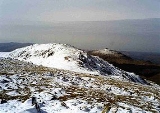
Summit and view
The summit of the fell is stony with two cairned rock outcrops, the south easterly is the higher while the north westerly offers the better view. There is a good view of the Scafell massif and the other Coniston fells are well seen along the ridge to the south. 200 metres north west of the main summit is a distinctive pointed rock, often called the “MatterhornMatterhorn
The Matterhorn , Monte Cervino or Mont Cervin , is a mountain in the Pennine Alps on the border between Switzerland and Italy. Its summit is 4,478 metres high, making it one of the highest peaks in the Alps. The four steep faces, rising above the surrounding glaciers, face the four compass points...
Rock”.