

Fulton Street Line (elevated)
Encyclopedia
Brooklyn
Brooklyn is the most populous of New York City's five boroughs, with nearly 2.6 million residents, and the second-largest in area. Since 1896, Brooklyn has had the same boundaries as Kings County, which is now the most populous county in New York State and the second-most densely populated...
, New York City
New York City
New York is the most populous city in the United States and the center of the New York Metropolitan Area, one of the most populous metropolitan areas in the world. New York exerts a significant impact upon global commerce, finance, media, art, fashion, research, technology, education, and...
, United States
United States
The United States of America is a federal constitutional republic comprising fifty states and a federal district...
. It ran above Fulton Street
Fulton Street (Brooklyn)
Fulton Street, named after engineer Robert Fulton, exists mainly in two parts in what are today two boroughs of New York City which Fulton linked by his steam ferries, and each segment has its own distinct identity. This entry deals with Fulton Street in Brooklyn, which now begins at the...
from Fulton Ferry, Brooklyn
Fulton Ferry, Brooklyn
Fulton Ferry is a neighborhood in the New York City borough of Brooklyn. The neighborhood is named for a prominent ferry line crossing the East River between Manhattan and Brooklyn, and is also the name of the ferry slip on the Brooklyn side...
in Downtown Brooklyn
Downtown Brooklyn
Downtown Brooklyn is the third largest central business district in New York City , and is located in the northwestern section of the borough of Brooklyn...
east to East New York
East New York, Brooklyn
East New York is a residential neighborhood located in the Eastern section of the borough of Brooklyn in New York City, United States. The neighborhood is part of Brooklyn Community Board 5...
, and then south on Van Sinderen Avenue (southbound) and Snediker Avenue (northbound), east on Pitkin Avenue, north on Euclid Avenue, and east on Liberty Avenue to Ozone Park, Queens
Ozone Park, Queens
Ozone Park is a working class neighborhood located in the southwestern section of the New York City borough of Queens bordering Woodhaven, Richmond Hill, South Ozone Park, Howard Beach, and City Line, Brooklyn....
. The portion in Brooklyn has been torn down, but most of the line in Queens
Queens
Queens is the easternmost of the five boroughs of New York City. The largest borough in area and the second-largest in population, it is coextensive with Queens County, an administrative division of New York state, in the United States....
has been connected to the New York City Subway
New York City Subway
The New York City Subway is a rapid transit system owned by the City of New York and leased to the New York City Transit Authority, a subsidiary agency of the Metropolitan Transportation Authority and also known as MTA New York City Transit...
and is now part of the IND Fulton Street Line
IND Fulton Street Line
The IND Fulton Street Line is a rapid transit line of the IND Division of the New York City Subway, extending from the Cranberry Street Tunnel under the East River through all of central Brooklyn to a terminus in Ozone Park, Queens. The IND Rockaway Line branches from it. It forms part of the A...
, an underground line that replaced the elevated line in Brooklyn. The structure was the main line of the Kings County Elevated Railway
Kings County Elevated Railway
The Kings County Elevated Railway Company was a builder and operator of elevated railway lines in Kings County, New York, now coextensive with the borough of Brooklyn in New York City. Its original services were operated with steam locomotives....
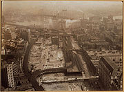
, first opened in 1888.
History
The Kings County Elevated RailwayKings County Elevated Railway
The Kings County Elevated Railway Company was a builder and operator of elevated railway lines in Kings County, New York, now coextensive with the borough of Brooklyn in New York City. Its original services were operated with steam locomotives....
opened the line, from dual western terminals at Fulton Ferry
Fulton Ferry, Brooklyn
Fulton Ferry is a neighborhood in the New York City borough of Brooklyn. The neighborhood is named for a prominent ferry line crossing the East River between Manhattan and Brooklyn, and is also the name of the ferry slip on the Brooklyn side...
and Brooklyn Bridge
Brooklyn Bridge
The Brooklyn Bridge is one of the oldest suspension bridges in the United States. Completed in 1883, it connects the New York City boroughs of Manhattan and Brooklyn by spanning the East River...
(Sands Street) east to Nostrand Avenue, on April 24, 1888. It was extended east to Albany Avenue on May 30, 1888; Albany Avenue was an eastbound-only station, and the westbound station just beyond at Sumner Avenue had yet to be completed, so it temporarily served both directions. The line was further extended to Ralph Avenue on September 20, 1888 and completed to BMT Fulton Street Line at the west end of East New York
East New York, Brooklyn
East New York is a residential neighborhood located in the Eastern section of the borough of Brooklyn in New York City, United States. The neighborhood is part of Brooklyn Community Board 5...
in early November.
The Fulton Elevated Railroad was incorporated on July 6, 1888 to build a disconnected line from Greenpoint
Greenpoint, Brooklyn
Greenpoint is the northernmost neighborhood in the New York City borough of Brooklyn. It is bordered on the southwest by Williamsburg at the Bushwick inlet, on the southeast by the Brooklyn-Queens Expressway and East Williamsburg, on the north by Newtown Creek and Long Island City, Queens at the...
south through Williamsburg
Williamsburg, Brooklyn
Williamsburg is a neighborhood in the New York City borough of Brooklyn, bordering Greenpoint to the north, Bedford-Stuyvesant to the south, Bushwick to the east and the East River to the west. The neighborhood is part of Brooklyn Community Board 1. The neighborhood is served by the NYPD's 90th ...
to Kent and Myrtle Avenues, and to extend the Kings County Elevated east beyond Rockaway Avenue to the city line. The former was not built, but construction soon began on the latter. The first piece, over Fulton Street and Williams Place, opened on July 4, 1889, connecting with the Long Island Rail Road
Long Island Rail Road
The Long Island Rail Road or LIRR is a commuter rail system serving the length of Long Island, New York. It is the busiest commuter railroad in North America, serving about 81.5 million passengers each year. Established in 1834 and having operated continuously since then, it is the oldest US...
's Manhattan Crossing station at the new terminal at Atlantic Avenue. It was extended further, over Snediker Avenue and Pitkin Avenue, to Van Siclen Avenue on November 18, 1889; due to a shortage of wood for a storage yard, a temporary shuttle was operated between Pennsylvania Avenue and Van Siclen Avenue until mid-December. Construction above Pitkin Avenue progressed to Linwood Street on February 22, 1892 and Montauk Avenue on March 21, 1892. The line was completed to Grant Avenue at City Line
City Line, Brooklyn
City Line is a sub-section of the East New York neighborhood in Brooklyn, New York City, bordering the neighborhoods of Cypress Hills to the north and Ozone Park, Queens to the east, and the Shore Parkway to the south...
on July 16, 1894, with the opening of a structure above Pitkin Avenue, Euclid Avenue, and Liberty Avenue.
The Kings County Elevated leased the Brooklyn and Brighton Beach Railroad on February 5, 1896. A two-block elevated connection between Franklin Avenue station and the Brighton Beach Line's Bedford station, including a new station at Dean Street
Dean Street (BMT Franklin Avenue Line)
Dean Street was a station on the BMT Franklin Avenue Line of the New York City Subway, with its entrance on Dean Street west of Franklin Avenue in the Bedford-Stuyvesant neighborhood of Brooklyn.- History :...
, opened on August 15, 1896, and the Kings County Elevated began operating trains between the Brooklyn Bridge (Sands Street) and Brighton Beach.
The final extension, from Grant Avenue east to Lefferts Avenue
Ozone Park-Lefferts Boulevard (IND Fulton Street Line)
Ozone Park – Lefferts Boulevard is an elevated terminal station on the IND Fulton Street Line of the New York City Subway, located at the intersection of Lefferts Boulevard and Liberty Avenue in Queens...
, was built under the Dual Contracts and opened on September 25, 1915. The Dual Contracts also triple-tracked the line. Trains last ran on the line west of Rockaway Avenue on May 31, 1940; a free transfer was provided to the IND Fulton Street Line
IND Fulton Street Line
The IND Fulton Street Line is a rapid transit line of the IND Division of the New York City Subway, extending from the Cranberry Street Tunnel under the East River through all of central Brooklyn to a terminus in Ozone Park, Queens. The IND Rockaway Line branches from it. It forms part of the A...
at Rockaway Avenue
Rockaway Avenue (IND Fulton Street Line)
Rockaway Avenue is a local station on the IND Fulton Street Line of the New York City Subway, located at the intersection of Rockaway Avenue and Fulton Street in Brooklyn. It is served by the C train all times except late nights when the A train takes over service.-Description:This is a four-track...
and a new "Fulton–Lexington Avenue
BMT 12
12 was the Brooklyn-Manhattan Transit Corporation's designation for trains that used the BMT Lexington Avenue Line. This number was used on service listings on company maps, but was never displayed on train equipment, nor were trains referred to as "12 trains" in the manner of the current system,...
" service via the Lexington Avenue Elevated west of East New York
East New York, Brooklyn
East New York is a residential neighborhood located in the Eastern section of the borough of Brooklyn in New York City, United States. The neighborhood is part of Brooklyn Community Board 5...
was introduced. The line west of Hudson Street was closed on April 26, 1956, and IND Fulton Street Line
IND Fulton Street Line
The IND Fulton Street Line is a rapid transit line of the IND Division of the New York City Subway, extending from the Cranberry Street Tunnel under the East River through all of central Brooklyn to a terminus in Ozone Park, Queens. The IND Rockaway Line branches from it. It forms part of the A...
trains began using the line east of Hudson Street on April 29.
Service patterns
The primary service pattern was a simple one-end-to-the-other operation, until May 31, 1940, when the 13 was cut back to Rockaway AvenueRockaway Avenue (BMT Fulton Street Line)
Rockaway Avenue was a station on the demolished BMT Fulton Street Line, served by the 13 train throughout its existence. It had two tracks and two side platforms, and a center island platform...
, and the BMT 12
BMT 12
12 was the Brooklyn-Manhattan Transit Corporation's designation for trains that used the BMT Lexington Avenue Line. This number was used on service listings on company maps, but was never displayed on train equipment, nor were trains referred to as "12 trains" in the manner of the current system,...
took over operations from downtown Brooklyn to Lefferts Boulevard.
Station listing
Most Fulton Street trains left the line at Sands Street and ended at Park RowPark Row (BMT station)
Park Row was a major elevated railway terminal constructed over the New York end of the Brooklyn Bridge, across from New York City Hall in Manhattan that served as the terminal for BMT services operating over the Brooklyn Bridge from the BMT Fulton Street Line, BMT Myrtle Avenue Line and their...
rather than Fulton Ferry.
| Miles from Fulton Ferry | Name | Location | Opened | Closed | Notes |
|---|---|---|---|---|---|
| 0.00 | Fulton Ferry Fulton Ferry (BMT Fulton Street Line) Fulton Ferry was a station on the demolished BMT Fulton Street Line. It had 2 tracks and 2 side platforms. The next stop to the south was Court Street. The station closed on May 31, 1940.-References:http://stationreporter.net/fultonel.htm... |
Fulton Ferry Fulton Ferry, Brooklyn Fulton Ferry is a neighborhood in the New York City borough of Brooklyn. The neighborhood is named for a prominent ferry line crossing the East River between Manhattan and Brooklyn, and is also the name of the ferry slip on the Brooklyn side... |
April 24, 1888 | May 31, 1940 | |
| N/A | Sands Street Sands Street (BMT station) Sands Street was a station on the demolished BMT Myrtle Avenue Line. It was a large complex with 2 levels. The upper level served trains going to Park Row. It had 4 tracks and 2 island platforms with the outside of the platforms serving streetcars. The lower level had a terminal and a loop for... |
Fulton Street and Sands Street | April 24, 1888 | May 31, 1940 | |
| 0.52/0.68 | Clark Street (eastbound) Tillary Street (westbound) |
Fulton Street, Clark Street, and Tillary Street | April 24, 1888 | ||
| 0.74 | Court Street Court Street (BMT Fulton Street Line) Court Street was a station on the demolished BMT Fulton Street Line. It had 2 tracks and 2 side platforms. The next stop to the west was Fulton Ferry for some trains and Sands Street for the rest. The next stop to the east was Boerum Place. It closed on May 31,... (eastbound) Myrtle Avenue (westbound) |
Fulton Street, Court Street, and Myrtle Avenue | April 24, 1888 | May 31, 1940 | |
| 0.91 | Boerum Place Boerum Place (BMT Fulton Street Line) Boerum Place was a station on the demolished BMT Fulton Street Line.It had 2 tracks and 2 offset side platforms. It was served by trains of the BMT Fulton Street Line, and until 1920, trains of the BMT Brighton Line. The next stop to the east was Elm Street-Duffield Street. The next stop to the... |
Fulton Street and Boerum Place | April 24, 1888 | May 31, 1940 | |
| 1.18 | Elm Place-Duffield Street Elm Place-Duffield Street (BMT Fulton Street Line) Elm Place-Duffield Street was a station on the demolished BMT Fulton Street Line in Brooklyn, New York City, United States.It had 2 tracks and 2 offset side platforms. It was served by trains of the BMT Fulton Street Line, and until 1920, trains of the BMT Brighton Line. The next stop to the east... |
Fulton Street, Elm Place, and Duffield Street | April 24, 1888 | May 31, 1940 | |
| 1.37 | Flatbush Avenue Flatbush Avenue (BMT Fulton Street Line) Flatbush Avenue was a station on the demolished BMT Fulton Street Line.It had 2 tracks and i island platform. It was served by trains of the BMT Fulton Street Line, and until 1920, trains of the BMT Brighton Line. The next stop to the east was Cumberland Avenue. The next stop to the west was Elm... |
Fulton Street and Flatbush Avenue | April 24, 1888 | May 31, 1940 | |
| 1.63 | Lafayette Avenue | Fulton Street and Lafayette Avenue | April 24, 1888 | May 31, 1940 | |
| 1.88 | Cumberland Avenue Cumberland Avenue (BMT Fulton Street Line) Cumberland Avenue was a station on the demolished BMT Fulton Street Line.It had 2 tracks and 2 offset side platforms. It was served by trains of the BMT Fulton Street Line, and until 1920, trains of the BMT Brighton Line. The next stop to the east was Vanderbilt Avenue. The next stop to the west... |
Fulton Street and Cumberland Street | April 24, 1888 | May 31, 1940 | connection to Greene and Gates Avenues Line Greene and Gates Avenues Line The Greene and Gates Avenues Line is a public transit line in Brooklyn, New York City, United States, running mostly along Fulton Street, Greene Avenue, and Gates Avenue between Downtown Brooklyn and Ridgewood, Queens... streetcars |
| 2.14 | Vanderbilt Avenue Vanderbilt Avenue (BMT Fulton Street Line) Vanderbilt Avenue was a station on the demolished BMT Fulton Street Line.It had 2 tracks and 2 side platforms. It was served by trains of the BMT Fulton Street Line, and until 1920, trains of the BMT Brighton Line. The next stop to the east was Grand Avenue. The next stop to the west was Cumberland... |
Fulton Street and Vanderbilt Avenue | April 24, 1888 | May 31, 1940 | connection to Vanderbilt Avenue Line Vanderbilt Avenue Line The Vanderbilt Avenue Line is a public transit line in Brooklyn, New York City, running along 7th Avenue and Vanderbilt Avenue between Kensington and Dumbo... streetcars |
| 2.48 | Grand Avenue Grand Avenue (BMT Fulton Street Line) Grand Avenue was a station on the demolished BMT Fulton Street Line. It had two tracks and two offset side platforms. It was served by trains of the BMT Fulton Street Line, and until 1920, trains of the BMT Brighton Line. The next stop to the east was Franklin Avenue . The next stop to the west was... |
Fulton Street and Grand Avenue | April 24, 1888 | May 31, 1940 | connection to Putnam Avenue Line Putnam Avenue Line The Putnam Avenue Line is a public transit line in Brooklyn, New York City, United States, running mostly along Fulton Street, Putnam Avenue, and Halsey Street between downtown Brooklyn and Ridgewood, Queens... streetcars |
| 2.81 | Franklin Avenue | Fulton Street and Franklin Avenue | April 24, 1888 | May 31, 1940 | connection to Brighton Beach Line trains and Franklin Avenue Line streetcars |
| 3.15 | Nostrand Avenue Nostrand Avenue (BMT Fulton Street Line) Nostrand Avenue was a station on the demolished BMT Fulton Street Line. It had 2 tracks and 2 side platforms. It was served by trains of the BMT Fulton Street Line. The next stop to the east was Brooklyn-Tompkins Avenue. The next stop to the west was Franklin Avenue. It closed on May 31,... |
Fulton Street and Nostrand Avenue | April 24, 1888 | May 31, 1940 | connection to Nostrand Avenue Line Nostrand Avenue Line (surface) The Nostrand Avenue Line is a public transit line in Brooklyn, New York City, United States, running mostly along Nostrand Avenue, as well as northbound on New York Avenue and Bedford Avenue , between Sheepshead Bay and Williamsburg... , Lorimer Street Line Lorimer Street Line The Lorimer Street Line is a public transit line in Brooklyn, New York City, United States, running along Lorimer Street, Franklin Avenue, and Classon Avenue between Bedford–Stuyvesant and Greenpoint... , Marcy Avenue Line, and Ocean Avenue Line streetcars |
| 3.44/3.47 | Brooklyn Avenue (eastbound) Tompkins Avenue (westbound)Brooklyn-Tompkins Avenue Brooklyn-Tompkins Avenue (BMT Fulton Street Line) Brooklyn-Tompkins Avenue was a station on the demolished BMT Fulton Street Line.It had 2 tracks and 2 side platforms. It was served by trains of the BMT Fulton Street Line. The next stop to the east was Albany-Sumner Avenue. The next stop to the west was Nostrand Avenue. It closed on May 31,... |
Fulton Street, Tompkins Avenue, and Brooklyn Avenue | May 30, 1888 | May 31, 1940 | connection to Tompkins Avenue Line streetcars |
| 3.78 | Albany Avenue (eastbound) Sumner Avenue (westbound)Albany-Sumner Avenue Albany-Sumner Avenue (BMT Fulton Street Line) Albany-Sumner Avenue was a station on the demolished BMT Fulton Street Line.It had 2 tracks and 2 side platforms. It was served by trains of the BMT Fulton Street Line. The next stop to the east was Utica Avenue. The next stop to the west was Brooklyn-Tompkins Avenue. It closed on May 31,... |
Fulton Street, Albany Avenue, and Sumner Avenue | May 30, 1888 | connection to Sumner Avenue Line streetcars | |
| Troy Avenue | Fulton Street and Troy Avenue | mid-1888 | May 31, 1940 | ||
| 4.15 | Reid Avenue Reid Avenue (BMT Fulton Street Line) Reid Avenue was a station on the demolished BMT Fulton Street Line. It had 2 tracks and 2 side platforms. It was served by trains of the BMT Fulton Street Line. The next stop to the east was Ralph Avenue. The next stop to the west was Albany-Sumner Avenue. It closed on May 31,... |
Fulton Street, Reid Avenue, and Utica Avenue | mid-1888 | May 31, 1940 | connection to Reid Avenue Line streetcars |
| 4.60 | Ralph Avenue Ralph Avenue (BMT Fulton Street Line) Ralph Avenue was a station on the demolished BMT Fulton Street Line.It had 2 tracks and 2 side platforms. It was served by trains of the BMT Fulton Street Line. The next stop to the east was Saratoga Avenue. The next stop to the west was Utica Avenue. It closed on May 31,... |
Fulton Street and Ralph Avenue | September 20, 1888 | May 31, 1940 | connection to Ralph Avenue Line Ralph Avenue Line The Ralph Avenue Line is a surface transit line on Ralph Avenue in Brooklyn, New York City, United States. Once a streetcar line, it is now part of the B47 bus route, operated by the New York City Transit Authority, and prior to 1995, it was the B78 route; the northern part of the route was part of... streetcars |
| Saratoga Avenue Saratoga Avenue (BMT Fulton Street Line) Saratoga Avenue was a station on the demolished BMT Fulton Street Line.It had 2 tracks and 2 side platforms. It was served by trains of the BMT Fulton Street Line. The next stop to the east was Rockaway Avenue. The next stop to the west was Ralph Avenue. It closed on May 31,... |
Fulton Street and Saratoga Avenue | December 3, 1888 | May 31, 1940 | ||
| 5.18 | Rockaway Avenue Rockaway Avenue (BMT Fulton Street Line) Rockaway Avenue was a station on the demolished BMT Fulton Street Line, served by the 13 train throughout its existence. It had two tracks and two side platforms, and a center island platform... |
Fulton Street and Rockaway Avenue | early November 1888 | April 26, 1956 | connection to Wilson Avenue Line Wilson Avenue Line The Wilson Avenue Line is a public transit line in Brooklyn, New York City, United States, running along Wilson Avenue and Rockaway Avenue between Williamsburg and Canarsie... streetcars |
| Manhattan Junction | Fulton Street and Sackman Street | by 1892 | remainder of complex still exists as Broadway Junction Broadway Junction (New York City Subway) Broadway Junction is a New York City Subway station complex shared by the elevated BMT Canarsie Line and BMT Jamaica Line, and the underground IND Fulton Street Line. It was also served by trains of the Fulton Street Elevated until that line closed in 1956... serving the trains |
||
| Atlantic Avenue | Williams Place, Snediker Avenue, and Atlantic Avenue | July 4, 1889 | present | still serves the train connection to Long Island Rail Road Long Island Rail Road The Long Island Rail Road or LIRR is a commuter rail system serving the length of Long Island, New York. It is the busiest commuter railroad in North America, serving about 81.5 million passengers each year. Established in 1834 and having operated continuously since then, it is the oldest US... at East New York East New York (LIRR station) East New York is a station on the Long Island Rail Road's Atlantic Branch in East New York, Brooklyn, where that branch passes through the historic Jamaica Pass. It is located at ground level, in the median of Atlantic Avenue, and underneath the elevated main lanes of Atlantic Avenue, with one side... station |
|
| Eastern Parkway Eastern Parkway (BMT Fulton Street Line) Eastern Parkway was a station on the demolished BMT Fulton Street Line.It had 2 tracks and 1 island platform. It was served by trains of the BMT Fulton Street Line. The next stop to the east was Pennsylvania Avenue. The next stop to the west was Atlantic Avenue. It closed on April 26,... |
Snediker Avenue and Eastern Parkway (Pitkin Avenue) | November 18, 1889 | between 1912 and 1924 | ||
| Hinsdale Street | Pitkin Avenue and Hinsdale Street | between 1912 and 1924 | April 26, 1956 | connection to Bergen Street Line Bergen Street Line The Bergen Street Line is a public transit line in Brooklyn, New York City, United States, running westbound mostly along Bergen Street, as well as eastbound on Dean Street , between downtown Brooklyn and Ocean Hill... streetcars |
|
| Pennsylvania Avenue Pennsylvania Avenue (BMT Fulton Street Line) Pennsylvania Avenue was a station on the demolished BMT Fulton Street Line.It had 2 tracks and 1 island platforms. It was served by trains of the BMT Fulton Street Line. The next stop to the east was Van Siclen Avenue. The next stop to the west was Eastern Parkway. It closed on April 26,... |
Pitkin Avenue and Pennsylvania Avenue | November 18, 1889 | April 26, 1956 | ||
| Van Siclen Avenue Van Siclen Avenue (BMT Fulton Street Line) Van Siclen Avenue was a station on the demolished BMT Fulton Street Line. It had 2 tracks and 1 island platform. It was served by trains of the BMT Fulton Street Line. The next stop to the east was Linwood Street. The next stop to the west was Pennsylvania Avenue. It closed on April 26,... |
Pitkin Avenue and Van Siclen Avenue | November 18, 1889 | April 26, 1956 | ||
| Linwood Street Linwood Street (BMT Fulton Street Line) Linwood Street was a station on the demolished BMT Fulton Street Line. It had 2 tracks and 1 island platform. It was served by trains of the BMT Fulton Street Line. The next stop to the east was Montauk Avenue. The next stop to the west was Van Siclen Avenue. It closed on April 26,... |
Pitkin Avenue and Linwood Street | February 22, 1892 | April 26, 1956 | ||
| Montauk Avenue Montauk Avenue (BMT Fulton Street Line) Montauk Avenue was a station on the demolished BMT Fulton Street Line.It had 2 tracks and 1 island platforms. It was served by trains of the BMT Fulton Street Line. The next stop to the east was Chestnut Street. The next stop to the west was Linwood Street. It closed on April 26,... |
Pitkin Avenue and Montauk Avenue | March 21, 1892 | April 26, 1956 | ||
| Chestnut Street Chestnut Street (BMT Fulton Street Line) Chestnut Street was a station on the demolished BMT Fulton Street Line.It had 2 tracks and 1 island platform. It was served by trains of the BMT Fulton Street Line. The next stop to the east was Crescent Street. The next stop to the west was Montauk Avenue. It closed on April 26,... |
Pitkin Avenue and Chestnut Street | July 16, 1894 | April 26, 1956 | ||
| Crescent Street Crescent Street (BMT Fulton Street Line) Crescent Street was a station on the demolished BMT Fulton Street Line.It had 2 tracks and 1 island platform. It was served by trains of the BMT Fulton Street Line. The next stop to the east was Grant Avenue. The next stop to the west was Chestnut Street. It closed on April 26,... |
Liberty Avenue and Crescent Street | July 16, 1894 | April 26, 1956 | ||
| Grant Avenue Grant Avenue (BMT Fulton Street Line) Grant Avenue was a station on the demolished BMT Fulton Street Line. It had two tracks and one island platform. It was the eastern terminal of the line until September 25, 1915, when Hudson Street–80th Street opened. The next stop to the west was Crescent Street. It closed on April 26,... |
Liberty Avenue and Grant Avenue | July 16, 1894 | April 26, 1956 | ||
| Hudson Street–80th Street | Liberty Avenue and 80th Street | September 25, 1915 | present | still serves the train | |
| Boyd Avenue–88th Street | Liberty Avenue and 88th Street | September 25, 1915 | present | still serves the train | |
| Rockaway Boulevard | Liberty Avenue and Rockaway Boulevard | September 25, 1915 | present | still serves the train | |
| Oxford Avenue–104th Street | Liberty Avenue and 104th Street | September 25, 1915 | present | still serves the train | |
| Greenwood Avenue–111th Street | Liberty Avenue and 111th Street | September 25, 1915 | present | still serves the train | |
| Lefferts Avenue–119th Street | Liberty Avenue and Lefferts Boulevard | September 25, 1915 | present | still serves the train |