

Fuencaliente
Encyclopedia
Fuencaliente, also Fuencaliente de la Palma (Spanish
meaning "hot spring") is located on the southern tip of La Palma
in the province of Santa Cruz de Tenerife
of the Canary Islands
. The seat of the municipality is Los Canarios which is located near Los Quemadas. It has been the seat since 1837. Valle Gran Rey is linked with a main highway encircling every part of the island and is located WSW of the capital Santa Cruz de la Palma
.
Fuencaliente offers panoramic views of El Hierro
to the south and La Gomera
to the southeast. In historic times, the territory was occupied by the Guanches
as Ahenguareme.
. The English brought these wine trees and produced for over 300 years. The today's production since 1945 produces 2 million litres of wine per year, it also has 800 ha of vineyards. Banana plantation is the second agricultural production.
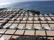
(438 m) is situated to the north and San Antonio is 657 m. About 70% of the municipality are protected areas including the famous parklands including Cumbre Vieja Natural Park or Parque natural de Cumbre Vieja, Reserva natural de los Volcanes de Fuencaliente = Fuencaliente Volcanos Natural Reserve, el Tamanca Protected Countryside/Paisaje protegido de Tamanca y el Sitio de interés científico de las Salinas de Fuencaliente (Salinas de Fuencaliente Scientific Sites of Interest) featuring salt paddies near the shoreline.
s.
Spanish language
Spanish , also known as Castilian , is a Romance language in the Ibero-Romance group that evolved from several languages and dialects in central-northern Iberia around the 9th century and gradually spread with the expansion of the Kingdom of Castile into central and southern Iberia during the...
meaning "hot spring") is located on the southern tip of La Palma
La Palma
La Palma is the most north-westerly of the Canary Islands. La Palma has an area of 706 km2 making it the fifth largest of the seven main Canary Islands...
in the province of Santa Cruz de Tenerife
Santa Cruz de Tenerife
Santa Cruz de Tenerife is the capital , second-most populous city of the Autonomous Community of the Canary Islands and the 21st largest city in Spain, with a population of 222,417 in 2009...
of the Canary Islands
Canary Islands
The Canary Islands , also known as the Canaries , is a Spanish archipelago located just off the northwest coast of mainland Africa, 100 km west of the border between Morocco and the Western Sahara. The Canaries are a Spanish autonomous community and an outermost region of the European Union...
. The seat of the municipality is Los Canarios which is located near Los Quemadas. It has been the seat since 1837. Valle Gran Rey is linked with a main highway encircling every part of the island and is located WSW of the capital Santa Cruz de la Palma
Santa Cruz de La Palma
Santa Cruz de la Palma is located on the eastern part of the island of La Palma in the province of Santa Cruz de Tenerife of the Canary Islands. Santa Cruz de la Palma is the second largest city and is the capital of the island...
.
Fuencaliente offers panoramic views of El Hierro
El Hierro
El Hierro, nicknamed Isla del Meridiano , is the smallest and farthest south and west of the Canary Islands , in the Atlantic Ocean off the coast of Africa, with a population of 10,162 .- Name :The name El Hierro, although phonetically identical to the Spanish word for 'iron', is generally thought...
to the south and La Gomera
La Gomera
La Gomera is one of Spain's Canary Islands, located in the Atlantic Ocean off the coast of Africa. In area, it is the second-smallest of the seven main islands of this group.- Political organization :...
to the southeast. In historic times, the territory was occupied by the Guanches
Guanches
Guanches is the name given to the aboriginal Berber inhabitants of the Canary Islands. It is believed that they migrated to the archipelago sometime between 1000 BCE and 100 BCE or perhaps earlier...
as Ahenguareme.
Geography
The coastline and the valley areas are made up of farmlands, while the mountainous areas are forested or grassy to the central and the northern parts.Economy
Its main industry are agriculture which produces wine, fishery and also tourism. The vineyards throughout Fuencaliente is famous malvasiaMalvasia
Malvasia is a group of wine grape varieties grown historically in the Mediterranean region, Balearic islands, Canary Islands and the island of Madeira, but now grown in many of the winemaking regions of the world...
. The English brought these wine trees and produced for over 300 years. The today's production since 1945 produces 2 million litres of wine per year, it also has 800 ha of vineyards. Banana plantation is the second agricultural production.
History
The origin of the name comes from a nearby spring known as Fuente Santa located near the coastline which is presently known as Playa de Echentive and was separated by lava and eliminated the springs in the 18th century. In 1971, Teneguía created a volcanic eruption and caused some damages to most of the properties. It also added small hectares of land to the island. Recently, the Canarian Council of Public Works in collaboration with the municipality had made a sounding in an area where water under the ground is at 60 °C. The objective in the future is that a gallery will be built in the area to extract these waters and take advantage of them in a special pool.Sites of interest
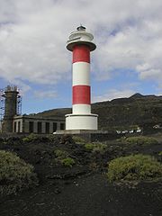
Fuencaliente's landmarks includes the Fuencaliente Volcano, a paddy-like farm named Salinas de Fuencaliente or Salinas Teneguía. A volcano named TeneguíaTeneguía
Teneguía is a cinder cone volcano situated on the island of La Palma, one of the Canary Islands.-1971 Eruption:This volcano is the source of the last volcanic eruption on Spanish soil –from October 26 to November 28, 1971. Earthquakes preceded the eruption...
(438 m) is situated to the north and San Antonio is 657 m. About 70% of the municipality are protected areas including the famous parklands including Cumbre Vieja Natural Park or Parque natural de Cumbre Vieja, Reserva natural de los Volcanes de Fuencaliente = Fuencaliente Volcanos Natural Reserve, el Tamanca Protected Countryside/Paisaje protegido de Tamanca y el Sitio de interés científico de las Salinas de Fuencaliente (Salinas de Fuencaliente Scientific Sites of Interest) featuring salt paddies near the shoreline.
Subdivisions
- Las Caletas (pop: 191)
- Los Canarios (pop: 755)
- El CharcoEl CharcoEl Charco is a town and municipality in the Nariño Department, Colombia....
(pop: 33) - La Fajana (pop: 43)
- Las Indias (pop: 646)
- Los Quemados (pop: 246)
Historical population
| Year | Population | Change | Density |
|---|---|---|---|
| 1900 | 1,650 | - | - |
| 1910 | 1,833 | 183 | - |
| 1920 | 1,841 | 8 | - |
| 1930 | 1,966 | 125 | - |
| 1940 | 2,212 | 246 | - |
| 1950 | 2,270 | 58 | - |
| 1960 | 1,943 | -327 | - |
| 1970 | 1,749 | -194 | - |
| 1980 | 1,664 | -85 | |
| 1990 | 1,822 | 158 | - |
| 1991 | 1,731 | - | - |
| 1996 | 1,735 | - | - |
| 2001 | 1,833 | - | 32.73/km² |
| 2002 | 1,801 | - | - |
| 2003 | 1,857 | - | - |
| 2004 | 1,877 | - | 33.03/km² |
| 2005 | 1,913 | - | - |
Other
Fuencaliente de la Palma has schools, a few lyceums, a gymnasium, churches, a small beach, a small port, a post office and a few squares plazaPlaza
Plaza is a Spanish word related to "field" which describes an open urban public space, such as a city square. All through Spanish America, the plaza mayor of each center of administration held three closely related institutions: the cathedral, the cabildo or administrative center, which might be...
s.
External links
- Map and aerial photos
- Street map: Street map from Mapquest, MapPoint or Google
- Satellite images: Google