
Fries, Virginia
Encyclopedia
Fries is a town in Grayson County
, Virginia
, United States
. The population was 484 as of the 200\10 census. Fries is part of the Blue Ridge
area, and shares in that region's old-time music
al traditions. The small town is home to the Festival by the New River, held in September at the town park on the banks of the New River, and the Old-Time Fiddlers' and Bluegrass Convention in August, hosted by the local volunteer fire department
.
.
and traditional, or "old-timey
" music and musicians, the region around Mount Airy
, North Carolina
is one of the few areas of the United States where this music has remained strongest, even among young people. The Old Fiddler's Convention, one of the most prominent traditional music contests in the United States, has been held annually in the nearby city of Galax since 1935. It has long attracted the best up-and-coming musicians in the bluegrass firmament. The Blue Ridge Music Center
with its amphitheather and music museum of old-time music is just a short distance away on the Blue Ridge Parkway
at Milepost 213.
According to the United States Census Bureau
, the town has a total area of 0.8 square miles (2.1 km²), of which, 0.6 square miles (1.7 km²) of it is land and 0.2 square miles (0.4 km²) of it (19.75%) is water.
 As of the census
of 2010, there were 484 people, 255 households, and 144 families residing in the town.
The following data is from the census
of 2000. The population density
was 947.8 people per square mile (364.7/km²). There were 337 housing units at an average density of 520.2 per square mile (200.2/km²). The racial makeup of the town was 98.70% White, 0.65% African American, 0.16% Native American, 0.16% from other races
, and 0.33% from two or more races. Hispanic or Latino of any race were 0.98% of the population.
There were 298 households out of which 17.4% had children under the age of 18 living with them, 46.3% were married couples
living together, 9.1% had a female householder with no husband present, and 40.6% were non-families. 39.3% of all households were made up of individuals and 23.8% had someone living alone who was 65 years of age or older. The average household size was 2.06 and the average family size was 2.71.
In the town the population was spread out with 16.8% under the age of 18, 7.0% from 18 to 24, 19.4% from 25 to 44, 28.8% from 45 to 64, and 28.0% who were 65 years of age or older. The median age was 49 years. For every 100 females there were 75.9 males. For every 100 females age 18 and over, there were 72.1 males.
The median income for a household in the town was $21,250, and the median income for a family was $30,250. Males had a median income of $27,946 versus $18,472 for females. The per capita income
for the town was $13,107. About 14.1% of families and 17.8% of the population were below the poverty line, including 26.8% of those under age 18 and 14.4% of those age 65 or over.
starts in Fries.
The historic Fries Recreation Center is located in downtown Fries http://www.friesreccenter.com
In 1910 an increasing need was seen for a community center for the employees of the mill. A site was selected that would be central for the townspeople and construction was begun for the Fries Lyceum.
The building provided reading rooms, and a skating rink became the gathering place for the young people of the town. In 1923, the Lyceum was renovated and reorganized as a Young Men's Christian Association (YMCA). The building now contained the only
gymnasium in the Carroll-Grayson area, along with a movie theatre. The need to expand was seen again in the late 1940s, and in 1948, a new lobby, bowling alley, kitchen and dining area, library, and additional game rooms were added. The swimming pool built in the front, facing new River, was the most popular addition.
Through the years semi-professional baseball was sponsored by the "Y". It has housed meetings for the Fries Garden Club,
organized in 1932, Fries Lions Club organized in 1938, and the Fries Women's Club organized in 1953.
The Fries Recreation center now hosts The Boy and Girl Scouts of America, Red Cross Training Courses, Hunter Safety Courses,
visiting community minded college students, and many more groups and activities.
The Fries Recreation Center also houses the Fries Town Hall and the Fries Police Department
Excerpts from Fries Recreation Center History
were written by Martha Nichols and Avery Bond
Grayson County, Virginia
As of the census of 2000, there were 17,917 people, 7,259 households, and 5,088 families residing in the county. The population density was 40 people per square mile . There were 9,123 housing units at an average density of 21 per square mile...
, Virginia
Virginia
The Commonwealth of Virginia , is a U.S. state on the Atlantic Coast of the Southern United States. Virginia is nicknamed the "Old Dominion" and sometimes the "Mother of Presidents" after the eight U.S. presidents born there...
, United States
United States
The United States of America is a federal constitutional republic comprising fifty states and a federal district...
. The population was 484 as of the 200\10 census. Fries is part of the Blue Ridge
Blue Ridge Mountains
The Blue Ridge Mountains are a physiographic province of the larger Appalachian Mountains range. This province consists of northern and southern physiographic regions, which divide near the Roanoke River gap. The mountain range is located in the eastern United States, starting at its southern-most...
area, and shares in that region's old-time music
Old-time music
Old-time music is a genre of North American folk music, with roots in the folk music of many countries, including England, Scotland, Ireland and countries in Africa. It developed along with various North American folk dances, such as square dance, buck dance, and clogging. The genre also...
al traditions. The small town is home to the Festival by the New River, held in September at the town park on the banks of the New River, and the Old-Time Fiddlers' and Bluegrass Convention in August, hosted by the local volunteer fire department
Fire department
A fire department or fire brigade is a public or private organization that provides fire protection for a certain jurisdiction, which typically is a municipality, county, or fire protection district...
.
History
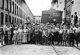
The Town of Fries is located on the north banks of the New River about 24 kilometers north-east of the Grayson County seat in Independence. It was named for North Carolina cotton mill owner Colonel Francis Fries. Jim 'Pipe' Carico (of Stephens Creek, Virginia, the nearest incorporated town) contacted Fries in 1900 and proposed Bartlett Falls on New River as a site for a hydroelectric dam that could power a cotton mill. Fries purchased the surrounding rural farmland then hired a local labor force to build a dam, a cotton mill and a full-service company owned town. By 1901, the New River Train was extended to the mill site and Fries petioned the Virginia State Legislature to incorrpoarate the new town of Carico, VA in honor of Jim 'Pipe' Carico. For reasons that are not well documented, the town name was instead legislatively changed to Fries, Virginia and officially incorporated in 1902. Despite the heavy reliance on manual labor, mules and oxen, the town's construction progressed quickly and the open call for employment spurred migration to the town. Around 300 houses, a post office, a church and a company commissary were wedged into the surrounding hillside before the mill began operation in February 1903. The mill continued in operation until 1989. At the time the mill closed, it employed 1,700 people. Fries High School also closed in 1989. The students from Fries, along with students from nearby Independence High School were combined to form Grayson County High School, located in IndependenceIndependence, Virginia
Independence is a town in Grayson County, Virginia, United States. The population was 971 at the 2000 census. It is the county seat of Grayson County. Independence is home to a major town celebration on July 4 every year, held in front of the 1908 courthouse. It features bluegrass and old-time...
.
Culture
Although the entire Appalachian region is known for its BluegrassBluegrass music
Bluegrass music is a form of American roots music, and a sub-genre of country music. It has mixed roots in Scottish, English, Welsh and Irish traditional music...
and traditional, or "old-timey
Old-time music
Old-time music is a genre of North American folk music, with roots in the folk music of many countries, including England, Scotland, Ireland and countries in Africa. It developed along with various North American folk dances, such as square dance, buck dance, and clogging. The genre also...
" music and musicians, the region around Mount Airy
Mount Airy, North Carolina
Mount Airy is a city in Surry County, North Carolina, United States. As of the 2010 census, the city population was 10,388.-History:Mount Airy was settled in the 1750s as a stagecoach stop on the road between Winston-Salem and Galax, Virginia. It was named for a nearby plantation...
, North Carolina
North Carolina
North Carolina is a state located in the southeastern United States. The state borders South Carolina and Georgia to the south, Tennessee to the west and Virginia to the north. North Carolina contains 100 counties. Its capital is Raleigh, and its largest city is Charlotte...
is one of the few areas of the United States where this music has remained strongest, even among young people. The Old Fiddler's Convention, one of the most prominent traditional music contests in the United States, has been held annually in the nearby city of Galax since 1935. It has long attracted the best up-and-coming musicians in the bluegrass firmament. The Blue Ridge Music Center
Blue Ridge Music Center
The Blue Ridge Music Center is part of the Blue Ridge Parkway system and is located at Milepost 213 near Galax, Virginia. The center celebrates the history and performance of old time mountain music of Virginia and North Carolina and is largely concerned with local artists who best show this...
with its amphitheather and music museum of old-time music is just a short distance away on the Blue Ridge Parkway
Blue Ridge Parkway
The Blue Ridge Parkway is a National Parkway and All-American Road in the United States, noted for its scenic beauty. It runs for 469 miles , mostly along the famous Blue Ridge, a major mountain chain that is part of the Appalachian Mountains...
at Milepost 213.
Geography
Fries is located at 36°42′56"N 80°58′33"W (36.715537, -80.975849).According to the United States Census Bureau
United States Census Bureau
The United States Census Bureau is the government agency that is responsible for the United States Census. It also gathers other national demographic and economic data...
, the town has a total area of 0.8 square miles (2.1 km²), of which, 0.6 square miles (1.7 km²) of it is land and 0.2 square miles (0.4 km²) of it (19.75%) is water.
Demographics
Census
A census is the procedure of systematically acquiring and recording information about the members of a given population. It is a regularly occurring and official count of a particular population. The term is used mostly in connection with national population and housing censuses; other common...
of 2010, there were 484 people, 255 households, and 144 families residing in the town.
The following data is from the census
Census
A census is the procedure of systematically acquiring and recording information about the members of a given population. It is a regularly occurring and official count of a particular population. The term is used mostly in connection with national population and housing censuses; other common...
of 2000. The population density
Population density
Population density is a measurement of population per unit area or unit volume. It is frequently applied to living organisms, and particularly to humans...
was 947.8 people per square mile (364.7/km²). There were 337 housing units at an average density of 520.2 per square mile (200.2/km²). The racial makeup of the town was 98.70% White, 0.65% African American, 0.16% Native American, 0.16% from other races
Race (United States Census)
Race and ethnicity in the United States Census, as defined by the Federal Office of Management and Budget and the United States Census Bureau, are self-identification data items in which residents choose the race or races with which they most closely identify, and indicate whether or not they are...
, and 0.33% from two or more races. Hispanic or Latino of any race were 0.98% of the population.
There were 298 households out of which 17.4% had children under the age of 18 living with them, 46.3% were married couples
Marriage
Marriage is a social union or legal contract between people that creates kinship. It is an institution in which interpersonal relationships, usually intimate and sexual, are acknowledged in a variety of ways, depending on the culture or subculture in which it is found...
living together, 9.1% had a female householder with no husband present, and 40.6% were non-families. 39.3% of all households were made up of individuals and 23.8% had someone living alone who was 65 years of age or older. The average household size was 2.06 and the average family size was 2.71.
In the town the population was spread out with 16.8% under the age of 18, 7.0% from 18 to 24, 19.4% from 25 to 44, 28.8% from 45 to 64, and 28.0% who were 65 years of age or older. The median age was 49 years. For every 100 females there were 75.9 males. For every 100 females age 18 and over, there were 72.1 males.
The median income for a household in the town was $21,250, and the median income for a family was $30,250. Males had a median income of $27,946 versus $18,472 for females. The per capita income
Per capita income
Per capita income or income per person is a measure of mean income within an economic aggregate, such as a country or city. It is calculated by taking a measure of all sources of income in the aggregate and dividing it by the total population...
for the town was $13,107. About 14.1% of families and 17.8% of the population were below the poverty line, including 26.8% of those under age 18 and 14.4% of those age 65 or over.
Recreation
New River Trail State ParkNew River Trail State Park
New River Trail State Park is a state park located in southern Virginia, United States. It parallels of the New River along an old railroad right-of-way, and is a designated National Recreation Trail....
starts in Fries.
The historic Fries Recreation Center is located in downtown Fries http://www.friesreccenter.com
In 1910 an increasing need was seen for a community center for the employees of the mill. A site was selected that would be central for the townspeople and construction was begun for the Fries Lyceum.
The building provided reading rooms, and a skating rink became the gathering place for the young people of the town. In 1923, the Lyceum was renovated and reorganized as a Young Men's Christian Association (YMCA). The building now contained the only
gymnasium in the Carroll-Grayson area, along with a movie theatre. The need to expand was seen again in the late 1940s, and in 1948, a new lobby, bowling alley, kitchen and dining area, library, and additional game rooms were added. The swimming pool built in the front, facing new River, was the most popular addition.
Through the years semi-professional baseball was sponsored by the "Y". It has housed meetings for the Fries Garden Club,
organized in 1932, Fries Lions Club organized in 1938, and the Fries Women's Club organized in 1953.
The Fries Recreation center now hosts The Boy and Girl Scouts of America, Red Cross Training Courses, Hunter Safety Courses,
visiting community minded college students, and many more groups and activities.
The Fries Recreation Center also houses the Fries Town Hall and the Fries Police Department
Excerpts from Fries Recreation Center History
were written by Martha Nichols and Avery Bond