
Fort Southwest Point
Encyclopedia
Fort Southwest Point was a federal frontier outpost at what is now Kingston, Tennessee
, in the southeastern United States. Constructed in 1797 and garrisoned by federal soldiers until 1811, the fort served as a major point of interaction between the Cherokee
and the United States government as well as a way station for early migrants travelling between Knoxville
and Nashville
.
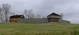
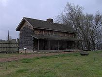
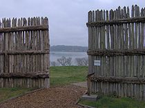
Although there are no records and few contemporary descriptions pertaining to the fort's design and structure, archaeological excavations conducted in the 1970s and 1980s have determined the fort's layout. Based on these findings, the City of Kingston and the Tennessee Division of Archaeology
have reconstructed part of the fort. The site is managed by the City of Kingston.
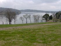 The Fort Southwest Point site is situated on a hill overlooking the confluence of the Tennessee River
and the Clinch River
. This confluence is now part of the Watts Bar Lake
impoundment of the Tennessee River, created by the completion of Watts Bar Dam
in 1942. The Emory River
empties into the Clinch approximately 5 miles (8 km) upstream from Southwest Point.
The Fort Southwest Point site is part of Southwest Point Park, which serves as both a historical and recreational area. The park is located along Tennessee State Route 58 approximately 2 miles (3.2 km) south of Interstate 40
and 1 miles (1.6 km) south of U.S. Route 70
.
in 1779, Colonel Arthur Campbell suggested the confluence of the Clinch and Tennessee as a possible site for a fort to the governor of Virginia
. Although Virginia never acted on Campbell's advice, the end of the war brought a flood of settlers into the Tennessee Valley, leading to increased conflict with the valley's Cherokee inhabitants. During this period, two events occurred that greatly enchanced Southwest Point's strategic importance: the construction of the Avery Trace in 1788 and the signing of the Treaty of Holston in 1791. The Avery Trace, which began at Southwest Point, became the key road connecting East Tennessee and Middle Tennessee until around 1800. The Treaty of Holston fixed the boundary between U.S. and Cherokee lands at the Clinch River, placing Southwest Point on the fringe of lands open to settlement in East Tennessee.
The waning years of the Chickamauga Wars
brought an increase in Cherokee attacks against the encroaching Euro-American settlers. Territorial governor William Blount
kept the militia on call for much of the early 1790s in order to protect settlers and enforce the terms of the Holston Treaty. John Sevier
, who commanded part of the militia, encamped at Southwest Point in 1792. By November of that year, Sevier's troops had completed a blockhouse at the site, which they used as a base until 1793 when federal troops arrived.
 Between 1793 and 1796, the Southwest Point Blockhouse was garrisoned by a federal contingent of 10 to 15 troops. During this time, a decision was made to replace the blockhouse with a much larger fort. While the early records regarding the fort's construction were destroyed in a fire, historians have determined that the fort was completed by federal troops under the command of Captain John Wade and Captain Richard Sparks in July of 1797. The fort was originally referred to as "Fort Butler" after Lieutenant-Colonel Thomas Butler (commander of federal forces in East Tennessee), but the name had been changed to "Fort Southwest Point" by 1798.
Lieutenant-Colonel Butler moved his headquarters to Fort Southwest Point in 1799, when nine companies (7 infantry, 1 artillery, and 1 dragoon
) totaling roughly 400-500 troops were garrisoned at the fort. Around the same time, lots had been sold for what eventually become the city of Kingston, named for Major Robert King, an officer stationed at the fort.
Among the first duties of the Southwest Point garrison was to remove individuals (known as "squatters") who had settled on Cherokee lands illegally. However, the first Treaty of Tellico— which Butler helped negotiate in 1798— resolved many of the issues regarding squatters, and reduced the need for federal troops in the area. By 1801, the Southwest Point garrison consisted of roughly 100 troops.
In 1801, Colonel Return J. Meigs
was appointed Cherokee Agent and Military Agent for the War Department in Tennessee. Although its garrison had been reduced, Fort Southwest Point served as an office for Meigs and as a distribution center for the Cherokee "annuity" (an annual payment of goods by the U.S. government in exchange for land cessions). Meigs immediately began negotiating with the Cherokee in hopes of obtaining permission to build a wagon road across their lands connecting Knoxville and Nashville. In 1805, the Third and Fourth Treaties of Tellico brought most of the Cumberland Plateau region under U.S. dominion, making the road possible. As the treaties pushed the U.S.-Cherokee border south to the Hiwassee River
, the garrison at Southwest Point was no longer needed. By 1807, Meigs and most of the federal garrison had relocated to the Hiwassee area. A skeleton contingent of less than 5 soldiers maintained Fort Southwest Point until 1811.
 The Southwest Point site was purchased by the Tennessee Valley Authority
in the 1930s in anticipation of the construction of Watts Bar Dam (the site is well above reservoir flood levels, however). In 1973, the University of Tennessee
conducted excavations at the site, locating six structures and evidence of prehistoric habitation. Between 1984 and 1986, the Tennessee Division of Archaeology
, seeking information to aide in the fort's reconstruction, conducted more extensive investigations at the site. These excavations uncovered nine additional structures and the palisade ditch, allowing researchers to determine the fort's original layout.
The prehistoric findings at the site include an infant burial, storage pits, and sherds. Hickory nut shells uncovered in a basin-style hearth returned a radiocarbon date
of approximately 1360 AD.
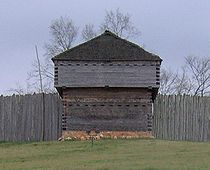 According to archaeological findings, Fort Southwest Point was 297 feet (90.5 m) x 175 feet (53.3 m), enclosing approximately 1.2 acres (4,856.2 m²). There were at least 15 structure located within the fort, the layout of which has been determined mostly from the remnants of their foundations.
Kingston, Tennessee
Kingston is a city in and the county seat of Roane County, Tennessee, United States, and is adjacent to Watts Bar Lake. Kingston, with a population of 5,264 at the 2000 United States census, is included in the Harriman, Tennessee Micropolitan Statistical Area....
, in the southeastern United States. Constructed in 1797 and garrisoned by federal soldiers until 1811, the fort served as a major point of interaction between the Cherokee
Cherokee
The Cherokee are a Native American people historically settled in the Southeastern United States . Linguistically, they are part of the Iroquoian language family...
and the United States government as well as a way station for early migrants travelling between Knoxville
Knoxville, Tennessee
Founded in 1786, Knoxville is the third-largest city in the U.S. state of Tennessee, U.S.A., behind Memphis and Nashville, and is the county seat of Knox County. It is the largest city in East Tennessee, and the second-largest city in the Appalachia region...
and Nashville
Nashville, Tennessee
Nashville is the capital of the U.S. state of Tennessee and the county seat of Davidson County. It is located on the Cumberland River in Davidson County, in the north-central part of the state. The city is a center for the health care, publishing, banking and transportation industries, and is home...
.
Although there are no records and few contemporary descriptions pertaining to the fort's design and structure, archaeological excavations conducted in the 1970s and 1980s have determined the fort's layout. Based on these findings, the City of Kingston and the Tennessee Division of Archaeology
Tennessee Division of Archaeology
The Tennessee Division of Archaeology is a division of the Tennessee Department of Environment and Conservation responsible for managing prehistoric archaeological sites on lands owned by the U.S...
have reconstructed part of the fort. The site is managed by the City of Kingston.
Geographical setting
Tennessee River
The Tennessee River is the largest tributary of the Ohio River. It is approximately 652 miles long and is located in the southeastern United States in the Tennessee Valley. The river was once popularly known as the Cherokee River, among other names...
and the Clinch River
Clinch River
The Clinch River rises in Southwest Virginia near Tazewell, Virginia and flows southwest through the Great Appalachian Valley, gathering various tributaries including the Powell River before joining the Tennessee River in East Tennessee.-Course:...
. This confluence is now part of the Watts Bar Lake
Watts Bar Lake
Watts Bar Lake is a reservoir on the Tennessee River created by Watts Bar Dam as part of the Tennessee Valley Authority system.-Geography:Located about midway between Chattanooga and Knoxville, the lake begins as the Tennessee River below Fort Loudon Dam in Lenoir City, Tennessee and stretches...
impoundment of the Tennessee River, created by the completion of Watts Bar Dam
Watts Bar Dam
Watts Bar Dam is a hydroelectric dam on the Tennessee River in Meigs County and Rhea County, Tennessee, USA. The dam is one of nine dams on the main Tennessee River channel operated by the Tennessee Valley Authority, which built the dam in early 1940s to provide flood control and electricity and...
in 1942. The Emory River
Emory River
The Emory River is a stream draining a portion of Tennessee's Cumberland Plateau.-Hydrography:The Emory River rises on the slopes of Frozen Head and Bird Mountain, prominent peaks in that part of the Cumberland Plateau in Morgan County, Tennessee. Frozen Head is the focus of a Tennessee state park...
empties into the Clinch approximately 5 miles (8 km) upstream from Southwest Point.
The Fort Southwest Point site is part of Southwest Point Park, which serves as both a historical and recreational area. The park is located along Tennessee State Route 58 approximately 2 miles (3.2 km) south of Interstate 40
Interstate 40
Interstate 40 is the third-longest major east–west Interstate Highway in the United States, after I-90 and I-80. Its western end is at Interstate 15 in Barstow, California; its eastern end is at a concurrency of U.S. Route 117 and North Carolina Highway 132 in Wilmington, North Carolina...
and 1 miles (1.6 km) south of U.S. Route 70
U.S. Route 70
U.S. Route 70 is an east–west United States highway that runs for 2,385 miles from eastern North Carolina to east-central Arizona. As can be derived from its number, it is a major east–west highway of the Southern and Southwestern United States...
.
The Southwest Point Blockhouse, 1792-1797
At the height of the American RevolutionAmerican Revolutionary War
The American Revolutionary War , the American War of Independence, or simply the Revolutionary War, began as a war between the Kingdom of Great Britain and thirteen British colonies in North America, and ended in a global war between several European great powers.The war was the result of the...
in 1779, Colonel Arthur Campbell suggested the confluence of the Clinch and Tennessee as a possible site for a fort to the governor of Virginia
Virginia
The Commonwealth of Virginia , is a U.S. state on the Atlantic Coast of the Southern United States. Virginia is nicknamed the "Old Dominion" and sometimes the "Mother of Presidents" after the eight U.S. presidents born there...
. Although Virginia never acted on Campbell's advice, the end of the war brought a flood of settlers into the Tennessee Valley, leading to increased conflict with the valley's Cherokee inhabitants. During this period, two events occurred that greatly enchanced Southwest Point's strategic importance: the construction of the Avery Trace in 1788 and the signing of the Treaty of Holston in 1791. The Avery Trace, which began at Southwest Point, became the key road connecting East Tennessee and Middle Tennessee until around 1800. The Treaty of Holston fixed the boundary between U.S. and Cherokee lands at the Clinch River, placing Southwest Point on the fringe of lands open to settlement in East Tennessee.
The waning years of the Chickamauga Wars
Chickamauga wars
The Chickamauga Wars were a series of raids, campaigns, ambushes, minor skirmishes, and several full-scale frontier battles which were a continuation of the Cherokee struggle against encroachment by American frontiersmen from the former British colonies...
brought an increase in Cherokee attacks against the encroaching Euro-American settlers. Territorial governor William Blount
William Blount
William Blount, was a United States statesman. He was a delegate to the Constitutional Convention for North Carolina, the first and only governor of the Southwest Territory, and Democratic-Republican Senator from Tennessee . He played a major role in establishing the state of Tennessee. He was the...
kept the militia on call for much of the early 1790s in order to protect settlers and enforce the terms of the Holston Treaty. John Sevier
John Sevier
John Sevier served four years as the only governor of the State of Franklin and twelve years as Governor of Tennessee. As a U.S. Representative from Tennessee from 1811 until his death...
, who commanded part of the militia, encamped at Southwest Point in 1792. By November of that year, Sevier's troops had completed a blockhouse at the site, which they used as a base until 1793 when federal troops arrived.
Fort Southwest Point, 1797-1811
Lieutenant-Colonel Butler moved his headquarters to Fort Southwest Point in 1799, when nine companies (7 infantry, 1 artillery, and 1 dragoon
Dragoon
The word dragoon originally meant mounted infantry, who were trained in horse riding as well as infantry fighting skills. However, usage altered over time and during the 18th century, dragoons evolved into conventional light cavalry units and personnel...
) totaling roughly 400-500 troops were garrisoned at the fort. Around the same time, lots had been sold for what eventually become the city of Kingston, named for Major Robert King, an officer stationed at the fort.
Among the first duties of the Southwest Point garrison was to remove individuals (known as "squatters") who had settled on Cherokee lands illegally. However, the first Treaty of Tellico— which Butler helped negotiate in 1798— resolved many of the issues regarding squatters, and reduced the need for federal troops in the area. By 1801, the Southwest Point garrison consisted of roughly 100 troops.
In 1801, Colonel Return J. Meigs
Return J. Meigs, Sr.
Return Jonathan Meigs [born December 17 or December 28 , 1740; died January 28, 1823] was a colonel who served in the Continental Army during the American Revolutionary War, was one of the founding settlers of the Northwest Territory in what is now the state of Ohio, and later served as a federal...
was appointed Cherokee Agent and Military Agent for the War Department in Tennessee. Although its garrison had been reduced, Fort Southwest Point served as an office for Meigs and as a distribution center for the Cherokee "annuity" (an annual payment of goods by the U.S. government in exchange for land cessions). Meigs immediately began negotiating with the Cherokee in hopes of obtaining permission to build a wagon road across their lands connecting Knoxville and Nashville. In 1805, the Third and Fourth Treaties of Tellico brought most of the Cumberland Plateau region under U.S. dominion, making the road possible. As the treaties pushed the U.S.-Cherokee border south to the Hiwassee River
Hiwassee River
The Hiwassee River has its headwaters on the north slope of Rocky Mountain in Towns County in northern Georgia and flows northward into North Carolina before turning westward into Tennessee, flowing into the Tennessee River a few miles west of State Route 58 in Meigs County, Tennessee...
, the garrison at Southwest Point was no longer needed. By 1807, Meigs and most of the federal garrison had relocated to the Hiwassee area. A skeleton contingent of less than 5 soldiers maintained Fort Southwest Point until 1811.
Archaeological findings
Tennessee Valley Authority
The Tennessee Valley Authority is a federally owned corporation in the United States created by congressional charter in May 1933 to provide navigation, flood control, electricity generation, fertilizer manufacturing, and economic development in the Tennessee Valley, a region particularly affected...
in the 1930s in anticipation of the construction of Watts Bar Dam (the site is well above reservoir flood levels, however). In 1973, the University of Tennessee
University of Tennessee
The University of Tennessee is a public land-grant university headquartered at Knoxville, Tennessee, United States...
conducted excavations at the site, locating six structures and evidence of prehistoric habitation. Between 1984 and 1986, the Tennessee Division of Archaeology
Tennessee Division of Archaeology
The Tennessee Division of Archaeology is a division of the Tennessee Department of Environment and Conservation responsible for managing prehistoric archaeological sites on lands owned by the U.S...
, seeking information to aide in the fort's reconstruction, conducted more extensive investigations at the site. These excavations uncovered nine additional structures and the palisade ditch, allowing researchers to determine the fort's original layout.
The prehistoric findings at the site include an infant burial, storage pits, and sherds. Hickory nut shells uncovered in a basin-style hearth returned a radiocarbon date
Radiocarbon dating
Radiocarbon dating is a radiometric dating method that uses the naturally occurring radioisotope carbon-14 to estimate the age of carbon-bearing materials up to about 58,000 to 62,000 years. Raw, i.e. uncalibrated, radiocarbon ages are usually reported in radiocarbon years "Before Present" ,...
of approximately 1360 AD.
Structures
- Structure 1 — 17 feet (5.2 m) x 22 feet (6.7 m), probably a corner blockhouse.
- Structure 2 — a vault, 14 feet (4.3 m) deep, probably a privy.
- Structure 3 — 70 feet (21.3 m) x 22 feet (6.7 m), probably officers' quarters and administrative offices.
- Structure 4 — 62 feet (18.9 m) x 22 feet (6.7 m), probably barracks. This structure included a drain that channeled water to a cistern.
- Structure 5 — 62 feet (18.9 m) x 22 feet (6.7 m), probably barracks.
- Structure 6 — 43.5 feet (13.3 m) x 22 feet (6.7 m), probably barracks.
- Structure 7 — appx. 83 feet (25.3 m) x 22 feet (6.7 m)
- Structure 8 — 43 feet (13.1 m) x 22 feet (6.7 m), possibly a distribution center.
- Structure 9 — a vault, 8 feet (2.4 m) x 10 feet (3 m) and 10.5 feet (3.2 m) deep, probably a privy.
- Structure 10 — 22 feet (6.7 m) x 18 feet (5.5 m), probably a corner blockhouse.
- Structure 11 — appx. 17 feet (5.2 m) x 18 feet (5.5 m), probably a blockhouse.
- Structure 12 — similar to Structures 2 and 9, probably a privy.
- Structure 13 — similar to Structures 10 and 11, probably a blockhouse.
- Structure 14 — 63 feet (19.2 m) x 17 feet (5.2 m), probably barracks.
- Structure 15 — 62 feet (18.9 m) x 23 feet (7 m), probably a supply building.