
Folkton
Encyclopedia
Folkton is a small village and civil parish at the foot of the Yorkshire Wolds
and on the edge of the Vale of Pickering
on an area known as Folkton Carr (carr meaning low lands) in the Scarborough
district of North Yorkshire
, England
.
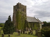
.jpg) There is a church dedicated to St John the Evangelist. Folkton House, the former rectory is located on Filey Road. Towards Flixton
There is a church dedicated to St John the Evangelist. Folkton House, the former rectory is located on Filey Road. Towards Flixton
is the former village school which is now closed, built in 1832.
According to the 2001 UK census
, Folkton parish had a population of 461.
 To the south are the Wolds and further north, across the Carrs and up the hills at the other side of the Vale is Scarborough, beyond which to the north-west are the Yorkshire Moors.
. Bowl-shaped, they have been called drums as the carvings would be upside down were they to be used as bowls. They were buried in a tumulus
that sits at the intersection of several natural pathways through the Dales. This tumulus has now been identified as one of a network that acted as a guide through the maze of hills and valleys that make up the Dales which would have been heavily forested at the time. They can now be seen on display at the British Museum
.
.
The village was also the site of a Roman
military base. Not much is known of this stage as subsequent building works have destroyed any archaeology; however, the regular finds of Roman artefacts such as coins and arrow heads indicate a substantial presence.
The village as it stands today was established with a small number of farm houses around 400 years ago. Later building added to and expanded these existing structures into larger houses and farms with attached barns. Many barns were then demolished during the 1800s to avoid the ‘Roof Tax’.
Yorkshire Wolds
The Yorkshire Wolds are low hills in the counties of East Riding of Yorkshire and North Yorkshire in northeastern England. The name also applies to the district in which the hills lie....
and on the edge of the Vale of Pickering
Vale of Pickering
The Vale of Pickering is a low-lying flat area of land in North Yorkshire, England. It is drained by the River Derwent. The landscape is rural with scattered villages and small market towns. It has been inhabited continuously from the Mesolithic period...
on an area known as Folkton Carr (carr meaning low lands) in the Scarborough
Scarborough (borough)
Scarborough is a non-metropolitan district and borough of North Yorkshire, England. In addition to the town of Scarborough, it covers a large stretch of the coast of Yorkshire, including Whitby and Filey....
district of North Yorkshire
North Yorkshire
North Yorkshire is a non-metropolitan or shire county located in the Yorkshire and the Humber region of England, and a ceremonial county primarily in that region but partly in North East England. Created in 1974 by the Local Government Act 1972 it covers an area of , making it the largest...
, England
England
England is a country that is part of the United Kingdom. It shares land borders with Scotland to the north and Wales to the west; the Irish Sea is to the north west, the Celtic Sea to the south west, with the North Sea to the east and the English Channel to the south separating it from continental...
.
Flixton, North Yorkshire
Flixton is a village in the Scarborough district of North Yorkshire, England. There is a public house, the Fox Hound Inn....
is the former village school which is now closed, built in 1832.
According to the 2001 UK census
United Kingdom Census 2001
A nationwide census, known as Census 2001, was conducted in the United Kingdom on Sunday, 29 April 2001. This was the 20th UK Census and recorded a resident population of 58,789,194....
, Folkton parish had a population of 461.
Geography
Prehistoric features
The area has been settled for many thousands of years. Above the village, at the top of Folkton Hill, was where the ‘Folkton Drums’ were discovered. They are a set of chalk (the predominant stone in the area) carvings from the Stone AgeStone Age
The Stone Age is a broad prehistoric period, lasting about 2.5 million years , during which humans and their predecessor species in the genus Homo, as well as the earlier partly contemporary genera Australopithecus and Paranthropus, widely used exclusively stone as their hard material in the...
. Bowl-shaped, they have been called drums as the carvings would be upside down were they to be used as bowls. They were buried in a tumulus
Tumulus
A tumulus is a mound of earth and stones raised over a grave or graves. Tumuli are also known as barrows, burial mounds, Hügelgrab or kurgans, and can be found throughout much of the world. A tumulus composed largely or entirely of stones is usually referred to as a cairn...
that sits at the intersection of several natural pathways through the Dales. This tumulus has now been identified as one of a network that acted as a guide through the maze of hills and valleys that make up the Dales which would have been heavily forested at the time. They can now be seen on display at the British Museum
British Museum
The British Museum is a museum of human history and culture in London. Its collections, which number more than seven million objects, are amongst the largest and most comprehensive in the world and originate from all continents, illustrating and documenting the story of human culture from its...
.
Modern history
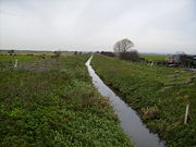
The Carr would have historically been lake or marsh depending on which climatic era is being discussed. Its natural state today would be as marsh land but it was drained in the 19th century to make room for agricultureAgriculture
Agriculture is the cultivation of animals, plants, fungi and other life forms for food, fiber, and other products used to sustain life. Agriculture was the key implement in the rise of sedentary human civilization, whereby farming of domesticated species created food surpluses that nurtured the...
.
The village was also the site of a Roman
Ancient Rome
Ancient Rome was a thriving civilization that grew on the Italian Peninsula as early as the 8th century BC. Located along the Mediterranean Sea and centered on the city of Rome, it expanded to one of the largest empires in the ancient world....
military base. Not much is known of this stage as subsequent building works have destroyed any archaeology; however, the regular finds of Roman artefacts such as coins and arrow heads indicate a substantial presence.
The village as it stands today was established with a small number of farm houses around 400 years ago. Later building added to and expanded these existing structures into larger houses and farms with attached barns. Many barns were then demolished during the 1800s to avoid the ‘Roof Tax’.